Introduction to Irrigation Design Sprinklers uniform application over


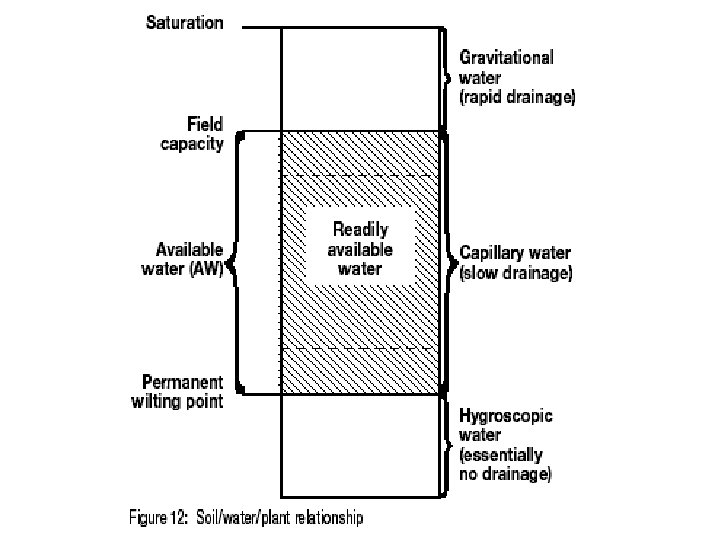


 = Field Capacity (FC) – Wilting")


- Slides: 40
Introduction to Irrigation Design Sprinklers – uniform application over entire area – lawns
Micro sprays – Water uniformly over small areas
Drip – Trickle – specific area – shrubs
Plants need water for • Cooling – evaporation and transpiration use energy – results ins cooling plants • Nutrient transport • Dispersion of plant expelled waste
Site Information needed • Soil texture, profile and infiltration rate • Water source – quantity and pressure, quality, cost • Layout of site – areas to be irrigated, elevations • Plants to be irrigated • Rainfall and ET rates • Budget
Water Conservation Potable to effluent Irrigation scheduling
Steps to develop plan 1. Obtaining site information 2. Determining the irrigation requirement 3. Determining water and power supply 4. Selecting sprinklers and other equipment 5. Lateral layout (or “circuiting” sprinklers), locating valves and main lines 6. Sizing pipe and valves and calculating total system pressure loss 7. Locating controllers and sizing wire 8. Preparing the final irrigation plan
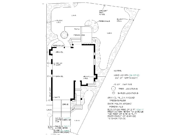
Site Plan • A site plan is a scaled drawing of the areas that are impacted by the irrigation system. • Before going through the effort of creating a site plan yourself, check to see if a plan already exists. • If the site being designed falls within city boundary, there may be a site plan or survey on record at the city or county planning/zoning department.
Site plan • Locate all buildings, walkways, driveways, parking areas, light or utility poles, retaining walls • Indicate where there are slopes and in which direction and how steeply the ground slopes. • Locate all trees and shrub areas and pinpoint the plant material on the drawing. • soil type • Location of any new planting areas and the types of vegetation that these areas will contain.
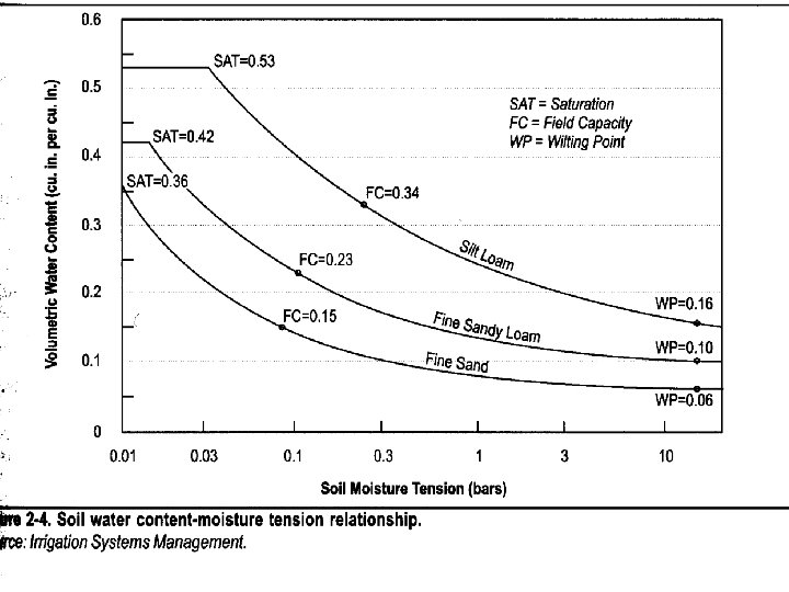
Available Soil Water • Soil absorbs and holds water in much the same way as a sponge. • A given texture and volume of soil will hold a given amount of moisture. • The intake rate of the soil will influence the rate at which water can be applied. • The ability of soil to hold moisture, and amount of moisture it can hold, will greatly affect the irrigation operational schedule
Soil moisture • Hygroscopic water is moisture that is held too tightly in the soil to be used by plants. • Capillary water is moisture that is held in the pore spaces of the soil and can be used by plants. • Gravitational water drains rapidly from the soil and is not readily available to be used by plants.
Source: USGS – Basic Ground-Water Hydrology - Heath
Source: USGS – Basic Ground-Water Hydrology - Heath
Source: USGS – Basic Ground-Water Hydrology - Heath
Source: USGS – Basic Ground-Water Hydrology - Heath
Source: USGS – Basic Ground-Water Hydrology - Heath
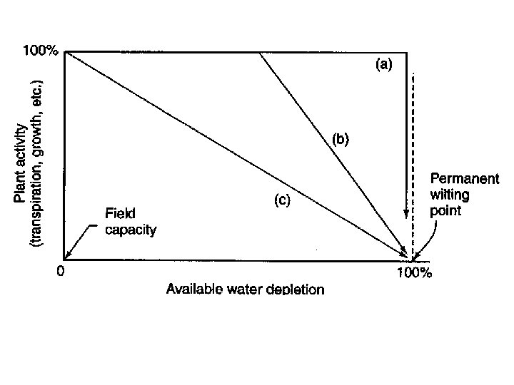
Soil moisture • The permanent wilting point represents the boundary between capillary water and hygroscopic water. • Because hygroscopic water is not usable by plants, continuous soil moisture levels below the permanent wilting point will result in the damage or death of the plants. • Field capacity represents the boundary between gravitational water and capillary water. It is the upper limit for soil moisture that is usable by plants.
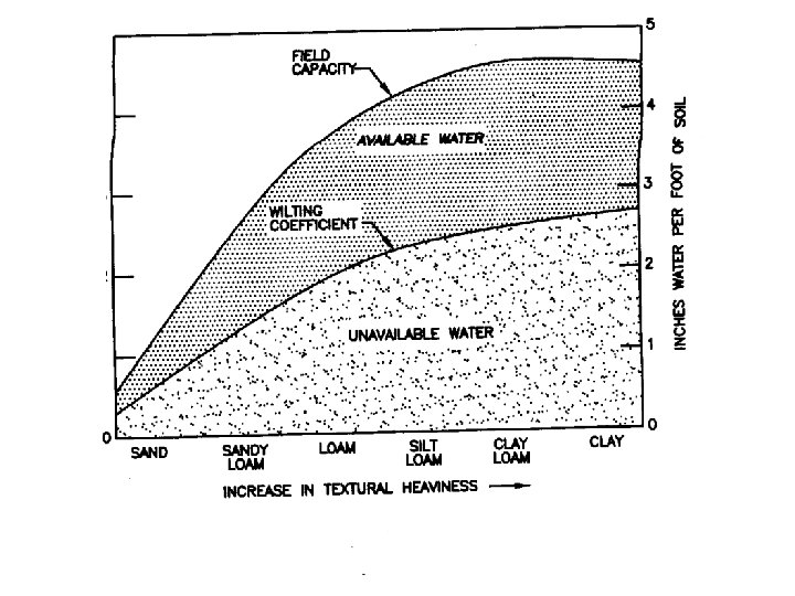
Available Water Soil Texture Very coarse-textured sands and fine sands Coarse-textured loamy sands and loamy fine sands Moderately coarse-textured sandy loams and fine sandy loams Medium textured very fine sandy loams, loam and silt loams Moderately fine-textured sandy clay loams, and silty clay loams Fine-textured sandy clays, silty clays, and clay Range Average in. /in. 0. 04 -0. 08 0. 06 -0. 10 0. 08 0. 10 -0. 15 0. 13 -0. 19 0. 16 0. 15 -0. 21 0. 18 0. 13 -0. 21 0. 17 Reference: USDA, NRCS, Engineering Field Manual Available for each soil group by soil horizon from NRCS Soil Surveys
Source: NRCS
Water needs • Soil AW (inches/foot or inches/inch) = Field Capacity (FC) – Wilting Point (WP) • For specific plant AW (in) = (soil AW) X Rooting Depth • Readily available water = plant AW X Allowable Depletion (use 50 % if not provided) • Irrigation interval = AW X AD/ usage per day • Efficiency = net water to root zone/gross water applied to system
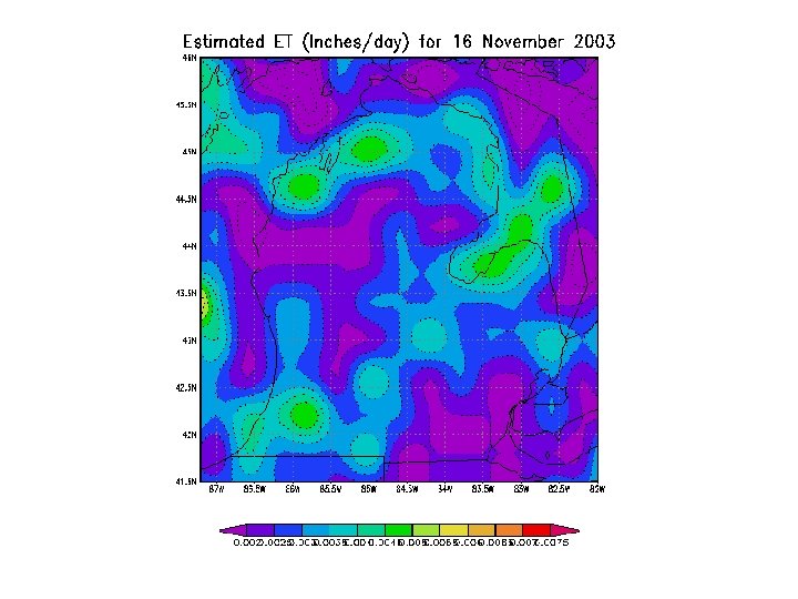
Reference Evapotranspiration • ETo or potential evapotanspiration represents a well watered, fully developed plant such as grass • Reference evapotranspiration is multiplied by a crop coefficient to obtain the ET rate for a specific crop • The crop coefficient varies throughout the growing season • For Example Corn at 20% = 0. 67 at 50%=1
Estimates of ET • • • Max and min temperatures Relative humidly Wind Net radiation Modified Penman to estimate ETo U of Wisconsin web site • http: //www. soils. wisc. edu/wimnext/et/miet. html
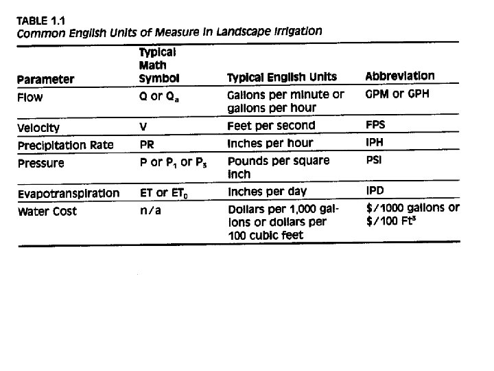
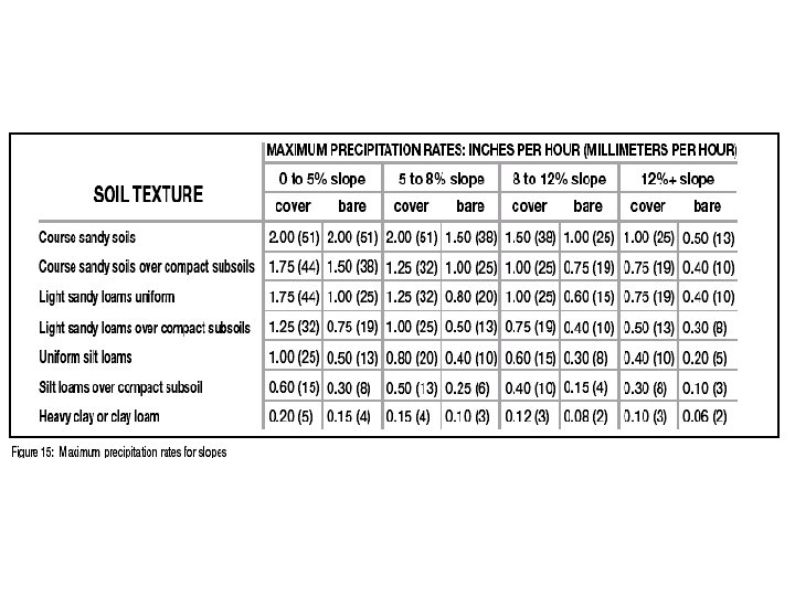
Precipitation Rates P = q/A Units MUST be consistent. For: P = precipitation rate (in/hr) q = flow onto area (gal/min) A = area (ft²) P = 96. 3 q/A
Precipitation Rate Importance • Do not want to apply water faster than the soil can absorb it • We need to know the time required to apply the correct amount of water
Sprinkler Irrigation Uniform application by overlapping nonuniform wetting paterns • Sprinkler spray heads – no moving parts - small area – pop up • Microsprays – overhead – small area • Rotary Sprinklers – Impact or gear driven
Rotary Sprinklers – uniform application over entire area – lawns
Micro sprays – Water uniformly over small areas
Drip – Trickle – specific area – shrubs
Technical Information • Nozzle - removable – controls velocity and flow • Operating Pressure – inc pressure – inc water flow and change wetting pattern • Radius of Throw – furthest point • Water Distribution Patterns • Trajectory – angle
Spray Heads Technical Information – operating pressure, flow, radius of throw, and nozzle options • Fixed head • Rotary Motor-driven • Rotary Impact • Bubbles