Introduction to Geographic Information Systems GIS part I
 part I Marcel Fortin GIS & Map Librarian,")


 0. 5000000 0. 0000000 -0. 5000000 627995. 1250249")


 • Arc. GIS (desktop) • •")

 Oracle")

 Feast or Famine ► Data Management")


- Slides: 50
Introduction to Geographic Information Systems (GIS) part I Marcel Fortin GIS & Map Librarian, University of Toronto gis. maps@utoronto. ca www. library. utoronto. ca/maplib This presentation: http: //www. library. utoronto. ca/maplib/temp/FIS_GIS_Workshop. ppt February 27 th, 2008
Objectives ► Understand the basic premises of GIS Cartography / Map Making Geographic Analysis ► By Learning the basics of GIS software and databases Different geographic datasets Basic map creation
Agenda ► What is not and what is GIS? ► What are Geospatial Data? ► Examples of GIS applications ► Software FYI ► Data FYI ► Where do Google Earth/Maps Fit in ► GIS Services/Education at the U of T
What is not GIS?
What is not a GIS – Scanned Maps
E-maps are not a GIS http: //www. ladocumentationfrancaise. fr/cartotheque/decoupage-administratif-france-2005. shtml
GPS IS NOT GIS http: //www. skyfly. cz/pristroj/image/mage 315. jpg
GIS not CAD
What is GIS? A GIS is a computer application with the capacity to assemble, store, manipulate, analyze, and display geographically referenced information (geospatial data)
What are Geospatial data? Data must “fit” with other data Geospatial data are georeferenced data (ie. they have a geographic field) • • • postal codes Province City longitude and latitude lot numbers concession numbers census tract wards Air photographs Etc.
Provinces
Postal Data
Longitude / Latitude
Parcel Information
Air Photos (or other raster imagery) 0. 5000000 0. 0000000 -0. 5000000 627995. 1250249 4836671. 8749751
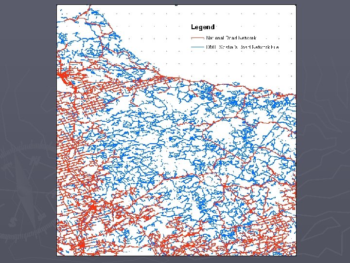
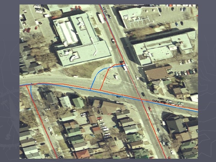
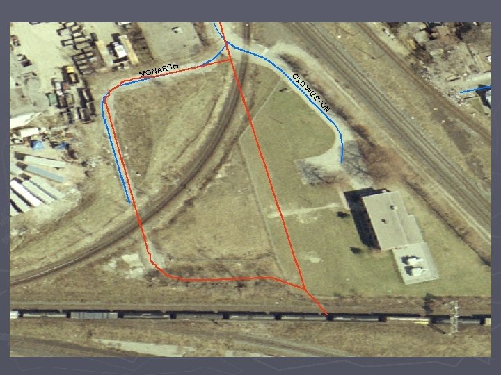
Road Network File
Combination of “Layers” 1999 Orthorectified Aerial photograph overlayed with the DMTI Spatial’s Street Network file for Ontario
Vector and Raster 01 Vector. Raster. mxd
Projection Issues projections. mxd
Thematic / Census Mapping census. mxd
Topographic Mapping 04. 0 Topographic. Mapping. mxd
3 D Mapping 3 dmapping. mxd LINE 175990487002002 FBS. dwg 030 m 11_0100_deme. dem (global mapper) 06_3 DToronto 1. sxd 06_3 DToronto 2. sxd 07_3 DVancouver. sxd
Software FYI
Software Campus “Standard” ESRI Site License (campus consortium) • Arc. GIS (desktop) • • • Arc. Info Arc. Editor Arc. View (free version now available from map library) • Arc. IMS (web) / Arc. SDE (spatial data engine) / Arc. GIS Server
Making Sense of “Arc. Wording” Arc. GIS Umbrella Arc. Info Arc. Editor Arc. View Flavour Arc. Map|Arc. Toolbox|Arc. Scene|Arc. Catalog 3 D Analyst, Spatial Analyst, etc. Extensions Functions
Other Software Options Commercial • • • Microsoft Map. Point (software licensing office) Oracle FME Auto. Cad Map Arc. GIS for Autocad (see http: //www. esri. com/software/arcgis-forautocad/index. html) • Mapinfo (site license via Geography Department) • Global Mapper Open Source • • • GRASS (desktop) Map. Server (web) Thuban QGIS See http: //www. freegis. org for more software titles
Data FYI
Data Issues ► Data Culture (Canada vs. USA) Feast or Famine ► Data Management ► Datasets of Interest ► Data Selection ► Data Creation
Data Culture : Feast or Famine Year Datasets Web Server / Intranet Media 1999 3 3 Gb (a few 100 3 CDs 2007 450 Over Tb (millions 1200 CDs/DVDs files) of files)
Data Culture – Mixed Bag ► Federal government ► Provincial Governments ► Municipal Geobase. ca NTDB DEMs now free! Geogratis. ca NTDB topo data and raster imagery now free! Ontario OGDE via libraries or vendors Manitoba free from download BC and Alberta pay for some free download for others Toronto pay Mississauga pay Brampton pay Burlington free Peterborough free London Free
Data Selection and Accuracy
Data Starting Point http: //www. library. utoronto. ca/maplib
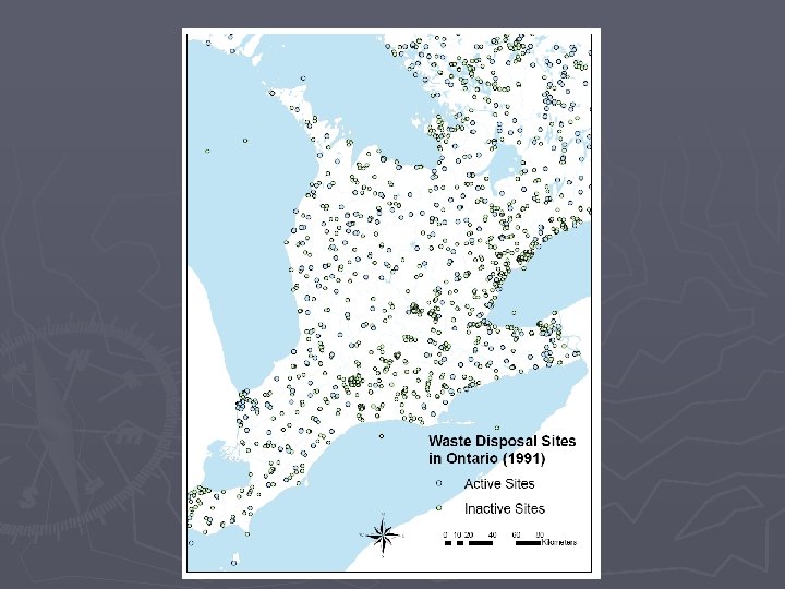
Data Creation
Data Creation – Waste Disposal Sites 08 Data. Creation. mxd
Future Historical GIS 1860’s Map of Toronto with roads overlayed. Note the Lakeshore highway’s location.
Open Street Map
Where do Google Earth/Maps fit in? Convergence or Confusion?
Google Earth The Good It’s Fun Geographic Literacy Geographic Interest Technology Boom Ease of Use Collaboration and sharing of hundreds of digitizing projects
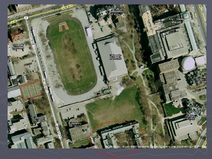
Google Earth The Good
Google Earth The Bad “Why do we still fund GIS Projects when there’s Google Earth” – Treasury Board Official at Depository Services Program Function
Google Earth The Ugly
Google Earth GIS Convergence Can now convert GIS Layers to KML format even in Arc. GIS http: //www. library. utoronto. ca/maplib/map. html Can do your own cartography Can do some analysis
Future GPS / GIS Convergence 11 GPS. mxd
Map, GIS, and Data Library Staff St. George Campus GIS Team • • • GIS & Map Librarian Data Librarian Map Cataloguer Map Processor GIS Analyst Graduate GIS Assistant(s) UTMississauga Campus • GIS and Data Librarian • GIS Technician
Communication & Teaching GEODATA-l Listserv New Datasets Software upgrades Workshops RCAT Lab One on one teaching One GGR grad course ESRI Virtual Campus