Introduction Section 1 The Sahel Section 2 East


 – Hausa of Niger – Fulani – Berber")
 • Density and distribution: – Population density is unevenly distributed.")


 • Empires and colonization: – The Mali Empire –")
 • Sudan today—a division: – North—Arab-speaking Muslims; Islamicoriented government")


 • Language—several African language groups: Afro -Asiatic, Nilo-Saharan, Congo-Kordofanian • Religion—Islam")


 • The people: – The Bantu—Uganda and Tanzania – Hutu—Rwanda")
 • Density and distribution: – Distribution is highly uneven due")


 – Arab traders – Persians • European colonization: –")
 • Colonialism created enormous problems for Africa’s people. •")


 • Health care—many problems exist. • The arts—visual arts of masks")


 • Density and distribution: – Distribution is very uneven, with")


 • The colonial era: – 1400 s—Portuguese set up")


 • Health care—uneven and limited • The arts—music and dance, weaving,")


 – Fulani – Bantu – Fang – Mbuti")
 • Density and distribution: – This region is the least")


 • Slavery: – Huge numbers of people from the")
 • European colonization: – It was not until the")
 • Instability after independence: – People in most Central")


 • Religion and family life are intertwined—numerous and diverse religions, but")


 – Zulu – San – Afrikaners Ethnic Composition of South")
 • Density and distribution: – Population densities vary widely across")


 • European colonization: – Arabs and Europeans settled in")
 • Challenges after independence: – Postcolonial rule has been")


 • Education—since independence, higher education has expanded. • Health care—AIDS has")


- Slides: 120
Introduction Section 1: The Sahel Section 2: East Africa Section 3: West Africa Section 4: Central Africa Section 5: Southern Africa Visual Summary
Current events in Africa south of the Sahara can best be understood by knowing about the region’s diverse peoples, its histories, and its cultures.
Section 1: The Sahel Places reflect the relationship between humans and the physical environment. The Sahel, at the edge of the Sahara, influences the ways of life in this subregion.
Section 2: East Africa Places reflect the relationship between humans and the physical environment. East Africa’s peoples, history, and cultures have been influenced by its location on the Atlantic coast.
Section 3: West Africa The characteristics and distribution of cultures influence human systems. West Africa’s religions and social structures play a major role in people’s daily lives.
Section 4: Central Africa Culture influences people’s perceptions of places and regions. While indigenous peoples built societies in response to the natural environment, European powers exploited the region.
Section 5: Southern Africa Geography is used to interpret the past, understand the present, and plan for the future. Knowledge of southern Africa’s natural resources and colonial past helps one fully know the region.
The Sahel, at the edge of the Sahara, influences the ways of life in this subregion.
The Sahel • indigenous • clan • domesticate • nuclear family • oral tradition • sanitation • patriarchal • survived • displaced • adequate
The Sahel A. Chad B. Senegal C. Mali D. Niger E. Sudan F. Kush G. Axum H. Mali Empire I. Songhai J. Timbuktu K. Darfur
The Sahel Are you familiar with the Sahel area? A. Very familiar B. Somewhat familiar C. Not familiar A. A B. B C. C
Population Patterns The changing physical environment and the many diverse ethnic groups have shaped population patterns in the Sahel. • The people: – Mandé people of Senegal and Mali – Wolof of Senegal
Population Patterns (cont. ) – Hausa of Niger – Fulani – Berber
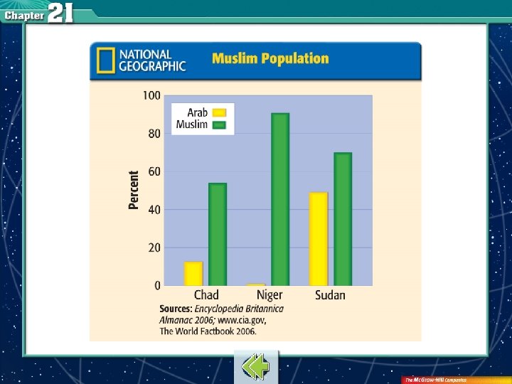
Population Patterns (cont. ) • Density and distribution: – Population density is unevenly distributed. – Average population density is about 103 people per square mile. – Sudan has the highest density. Muslim Population
The average level of urbanization in the Sahel countries is what percentage? A. 25% B. 32% C. 45% D. 57% A. B. C. D. A B C D
History and Government The physical environment and the relative location of the Sahel have drawn together diverse cultures that continue to influence the subregion. • First civilizations: – Egyptian civilization – The kingdom of Kush
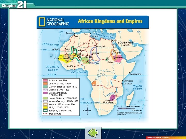
History and Government (cont. ) • Empires and colonization: – The Mali Empire – Songhai Empire – Complete European control by 1914 – Colonies gained independence by 1950 s African Kingdoms and Empires
History and Government (cont. ) • Sudan today—a division: – North—Arab-speaking Muslims; Islamicoriented government – South—live in rural areas; subsistence economy; secular government
How did Europe first become involved with Africa? A. Slave trade B. Trading goods C. Tourism D. Mission work A. B. C. D. A B C D
Culture Although diverse, the cultures of the Sahel region share many similarities. • The arts—African art—often expressing traditional religious beliefs—comes in many forms, from ritual masks to rhythmic drum music to folktales. • Family life—strong family ties valued.
Culture (cont. ) • Language—several African language groups: Afro -Asiatic, Nilo-Saharan, Congo-Kordofanian • Religion—Islam • Education—low school enrollment and literacy rates • Health care—poor health care
Are most families in this region patriarchal or matriarchal? A. Patriarchal B. Matriarchal A. A B. B
East Africa’s peoples, history, and cultures have been influenced by its location on the Atlantic coast.
East Africa • lingua franca • emerged • purchase
East Africa A. Uganda B. Tanzania C. Rwanda D. Burundi E. Kenya F. Ethiopia G. Somalia H. Djibouti I. Eritrea J. Dar es Salaam K. Dodoma
East Africa Which ocean has highly influenced the lives of people in East Africa? A. Atlantic B. Pacific C. Indian D. Mediterranean A. B. C. D. A B C D
Population Patterns The populations of East Africa have been shaped by their location along the long coast-line of the Indian Ocean. • In East African countries today, one ethnic group is the majority in a country.
Population Patterns (cont. ) • The people: – The Bantu—Uganda and Tanzania – Hutu—Rwanda and Burundi
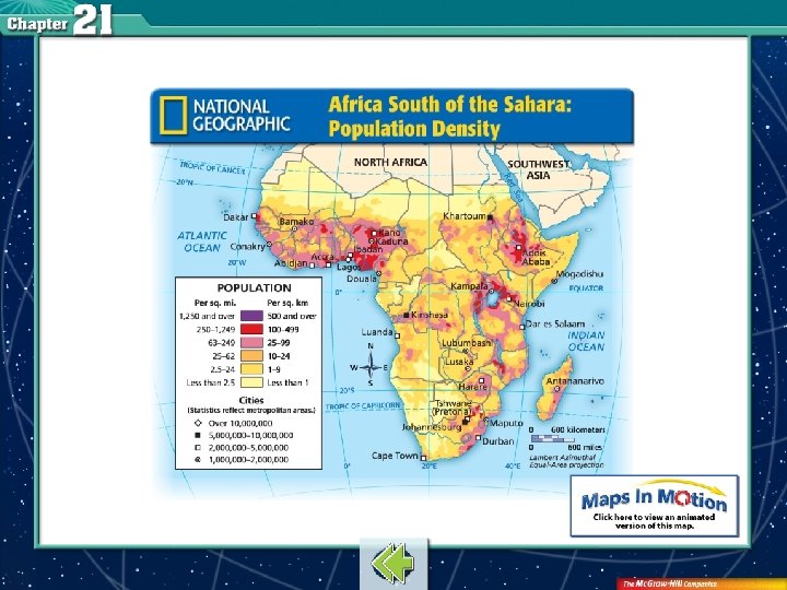
Population Patterns (cont. ) • Density and distribution: – Distribution is highly uneven due to land climate. – City dwellers, nomads, and farmers live in this region. Africa South of the Sahara: Population Density
Which of the following contribute to East Africa’s problem with feeding its population? A. Soaring population growth B. Economic challenges C. Actions of governments and farmers D. Droughts E. All of the above A. B. C. D. E. A B C D E
History and Government Throughout much of its history, East Africa’s location has attracted people from many continents. • Early peoples and kingdoms: – Possible place of origin for all humankind – Kingdom of Axum – Djibouti people
History and Government (cont. ) – Arab traders – Persians • European colonization: – Britain, France, Germany, Portugal – British doctor and missionary David Livingstone
History and Government (cont. ) • Colonialism created enormous problems for Africa’s people. • European powers granted colonies independence in the 1960 s. • However, the newly independent countries faced (and still face) internal and external strife.
The Europeans divided Africa into how many different countries? A. More than 20 B. More than 30 C. More than 40 D. More than 50 A. B. C. D. A B C D
Culture Common elements such as language and religion connect the cultures of East Africa. • Language—Congo-Kordofanian, Nilo-Saharan, Afro. Asiatic; English and French • Religion—Christian or Muslim • Education—levels of education vary throughout the region; few complete secondary education.
Culture (cont. ) • Health care—many problems exist. • The arts—visual arts of masks and textiles; forms of music, dance, and oral traditions • Ways of life in East Africa are as varied as the ethnic groups who live there.
What is the most common language in Sudan and Eritrea? A. French B. Yoruba C. Arabic D. Portuguese A. B. C. D. A B C D
West Africa’s religions and social structures play a major role in people’s daily lives.
West Africa • urbanization • service centers • route • seeking • legal
West Africa A. Guinea B. Côte d’lvoire C. Togo D. Benin E. Nigeria F. Niger G. Gambia H. Senegal I. Ghana J. Mali K. Mauritania
West Africa Challenges that West Africa faces include which of the following? A. Negative population growth B. Ethnic conflict C. Agriculture A. A B. B C. C
Population Patterns The location and densities of West Africa’s populations affect people’s way of life. • The people: – Hausa – Yoruba
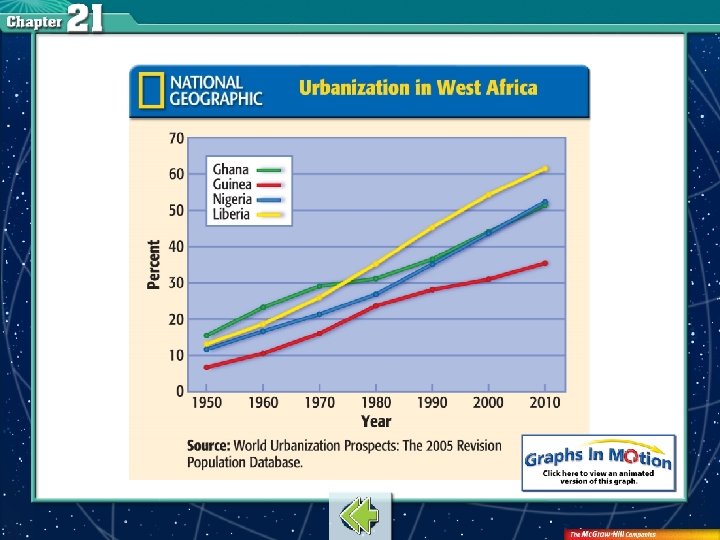
Population Patterns (cont. ) • Density and distribution: – Distribution is very uneven, with most people living along the coast and river plains. – Africa’s rate of urbanization is the world’s fastest (although only 44% live in cities). Urbanization in West Africa
More West Africans are moving to the city for what reason? A. Better jobs B. Public services C. Health care D. All of the above A. B. C. D. A B C D
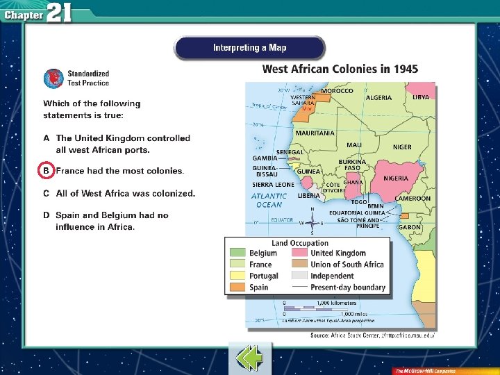
History and Government West Africa’s history has been shaped by indigenous and outside forces, each with their own cultures. • Early empires: – Ghana Empire – Mali Empire
History and Government (cont. ) • The colonial era: – 1400 s—Portuguese set up trading posts along the African coast. – 1600 s and 1700 s—Europeans were actively trading with Africans, including slaves. – French colonizers were trying to end slavery during this time as well.
Which colony did the British form from several smaller ethnic territories in 1914? A. Ghana B. Mali C. Nigeria D. Timbuktu A. B. C. D. A B C D
Culture West African culture has been shaped by hundreds of years of European and Arab influences. • Language—hundreds of languages are spoken; English, French, Arabic, Yoruba • Religion—Islam, Christianity, traditional African religions • Education—inconsistent throughout the region
Culture (cont. ) • Health care—uneven and limited • The arts—music and dance, weaving, masks, sculptures
What kind of range is found in literacy rates in this region? A. 5– 40% B. 18– 75% C. 25– 60% D. 50– 80% A. B. C. D. A B C D
Central Africa While indigenous peoples built societies in response to the natural environment, European powers exploited the region.
Central Africa • pidgin • migrated • transport
Central Africa A. Democratic Republic of the Congo B. Cameroon C. Central African Republic D. Gabon E. Equatorial Guinea F. Bioko H. Senegal G. São Tomé and Príncipe I. Ghana
Central Africa Which of the following covers more than half of Central Africa? A. Mountains B. Rainforest C. Rivers D. Lakes A. A B. B C. C D. D
Population Patterns Groups of people throughout Central Africa usually have a shared culture, depending on where they live. • The people: – This region is home to hundreds of ethnic groups. – Most people exist by subsistence agriculture or raising cattle.
Population Patterns (cont. ) – Fulani – Bantu – Fang – Mbuti
Population Patterns (cont. ) • Density and distribution: – This region is the least densely populated on the continent. – More densely populated areas are in the Republic of the Congo, Cameroon, and the Democratic Republic of the Congo.
Which country has the most densely populated area? A. Republic of the Congo B. Cameroon C. Democratic Republic of the Congo D. Central African Republic A. A B. B C. C D. D
History and Government Central Africa was the location of early migrations and, later, of European systems of slavery, colonization, and plantation economies. • Early settlement: – Bantu-speaking people established settlements in the region by A. D. 800.
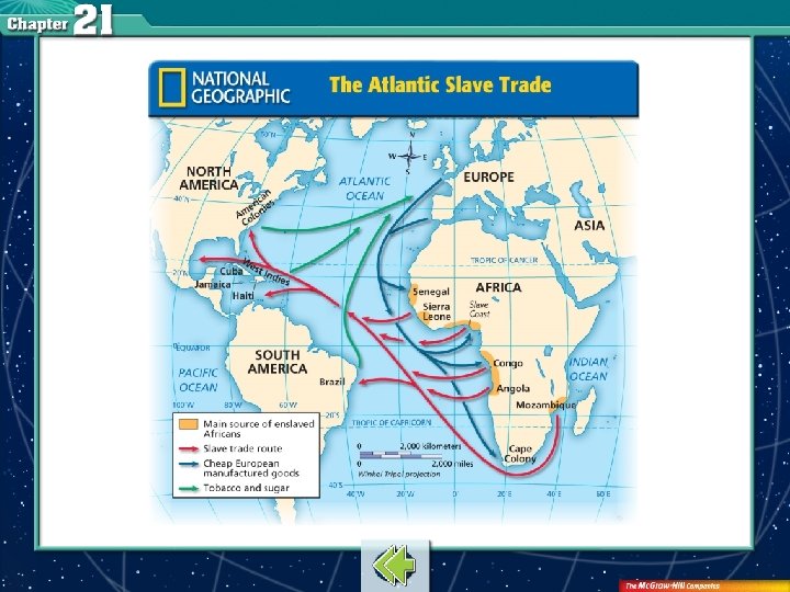
History and Government (cont. ) • Slavery: – Huge numbers of people from the African interior were sold into slavery. The Atlantic Slave Trade
History and Government (cont. ) • European colonization: – It was not until the 1800 s that large areas of Central Africa were colonized. – By 1960, all the French colonies had become independent countries.
History and Government (cont. ) • Instability after independence: – People in most Central African countries experienced periods of ethnic strife, harsh rule, and human rights abuses after independence.
How did France gain control of the Republic of the Congo in the late 1800 s? A. Promising protection from Belgium B. Enslaving the people C. Providing food and water D. Defeating the king A. A B. B C. C D. D
Culture The many diverse cultures of Central Africa share similar experiences as a result of geography, their history, and their current situation. • Language— 700 local languages in the Democratic Republic of the Congo alone; French; pidgin • The arts—Mangbetu pottery, sculpture
Culture (cont. ) • Religion and family life are intertwined—numerous and diverse religions, but they share many common elements. • Some Christianity found as well. • Education—many systems are strained. • Health care—this is also strained in most areas.
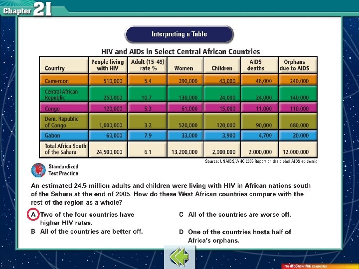
Which of the following are primary health care concerns for Central Africa? A. Lack of safe drinking water B. Shortage of vaccines for curable diseases C. Rising number of AIDS victims D. All of the above A. A B. B C. C D. D
Southern Africa Understanding southern Africa’s natural resources and colonial past helps one fully know the region.
Southern Africa • coup d′état • apartheid • civil • denied • universal suffrage
Southern Africa A. Zambia B. Zimbabwe C. Malawi D. Mozambique E. Swaziland F. South Africa G. Namibia H. Lesotho I. Johannesburg J. Madagascar K. Angola M. Botswana L. Comoros N. Mauritius
Southern Africa The San people of South Africa depend on what for their survival? A. Livestock B. Farming C. Hunting/gathering D. Business A. A B. B C. C D. D
Population Patterns Southern Africa is undergoing significant population changes as a result of its colonial history and present challenges. • The people: – Sena – Bantu – Swazi
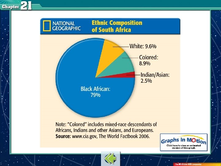
Population Patterns (cont. ) – Zulu – San – Afrikaners Ethnic Composition of South Africa
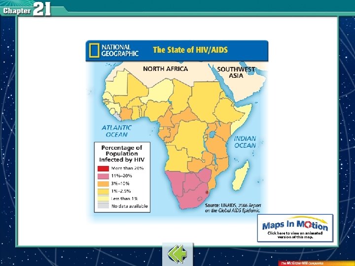
Population Patterns (cont. ) • Density and distribution: – Population densities vary widely across the region. – Many people are moving to urban areas to work in gold and diamond mines. – Despite population explosions in parts of Africa, AIDS is expected to reduce the populations of many of the region’s countries. The State of HIV/AIDS
How much of Africa’s population south of the Sahara will live in cities by 2030? A. A quarter B. More than one-third C. More than half D. Three-fourths A. A B. B C. C D. D
History and Government Situations created by colonial rule challenge southern Africa today and will continue to do so into the future. • Early cultures: – Zulu – Bantu
History and Government (cont. ) • European colonization: – Arabs and Europeans settled in southern Africa for economic reasons. – The Portuguese controlled Angola, Mozambique, Comoros, and Mauritius.
History and Government (cont. ) • Challenges after independence: – Postcolonial rule has been a difficult adjustment for most African countries. – Exceptions—Botswana, Mauritius – Apartheid was ended in the early 1990 s, but problems continue today.
Who was the first black president of South Africa? A. Nzinga Mbemba B. Mobutu Sese C. Nelson Mandela D. Paul Solopek A. A B. B C. C D. D
Culture While countries in southern Africa enjoy more freedoms under independence, they face serious economic and health-care problems. • Language—African languages; English, French, Afrikaans • Religion—Christianity as well as traditional religions
Culture (cont. ) • Education—since independence, higher education has expanded. • Health care—AIDS has reached epidemic proportions and most can’t afford drug treatments. • The arts—indigenous crafts, music, and dancing • Leisure—playing games and spending time with family
City dwellers often wear Western-style clothing, use cell phones, and watch television. A. True B. False A. A B. B
Population Patterns • Africa south of the Sahara has the world’s highest birthrates and death rates. • The high death rate is the result of poverty, disease, and conflict. • Despite high death rates, the population of Africa south of the Sahara is growing faster than any other region of the world.
Urban Growth • Although Africa south of the Sahara is one of the least urbanized regions of the world, it has the world’s fastest rate of urbanization. • Cities have better job opportunities, health care, and public services that attract people from rural areas. • Most cities in the region are built along the coast, along rivers, or in areas rich in natural resources. Almost all of the major cities began as centers of trade.
Historical Legacy • In its early history, Africa was home to major trading kingdoms, like Songhai, Ghana, Mali, Kush, and Axum. • As Europeans began exploring the globe, they traded with African rulers for gold and other goods. Later they also traded for enslaved people. • The European powers later divided Africa into colonies. They extracted resources and promoted European culture at the expense of traditional African ways.
The Shona were skilled builders and stonemasons, probably were very well organized, and had many workers and the ability to feed them.
indigenous native to a place
domesticate to adapt plants and animals from the wild to make them useful to people
oral tradition stories passed down from generation to generation by word of mouth
patriarchal relating to a social group headed by a male family member
clan tribal community or large group of people related to one another
nuclear family group made up of a husband, wife, and children
sanitation disposal of waste products
lingua franca a common language used among people with different native languages
urbanization the movement of people from rural areas into cities
service center convenient business location for rural dwellers
pidgin simplified speech used among people who speak different languages
coup d′état a violent overthrow of the government
apartheid policy of strict separation of the races adopted in South Africa in the 1940 s
universal suffrage equal voting rights for all adult citizens of a nation
To navigate within this Presentation Plus! product: Click the Forward button to go to the next slide. Click the Previous button to return to the previous slide. Click the Return button to return to the main presentation. Click the Home button to return to the Chapter Menu. Click the Help button to access this screen. Click the Exit button or press the Escape key [Esc] to end the chapter slide show. Links to Maps in Motion, static maps and charts, and transparencies appear near the bottom of slides as they are relevant. Links to the Reference Atlas and Geography Online are located on the navigation bar of most screens.
This slide is intentionally blank.