Introduction of KMA data assimilation system with FGAT





- Slides: 36

Introduction of KMA data assimilation system with FGAT Sei-Young Park L KMA/Numerical Weather Prediction Division, Korea Meteorological Administration Numerical Weather Prediction

Contents Introduction of KMA NWP system KMA data assimilation system Ø History and status (satellite data assimilation & unified 3 dvar) Ø First Guess at Appropriate Time (FGAT) On-going & plan Numerical Weather Prediction Division, Korea Meteorological Administration Numerical Weather Prediction

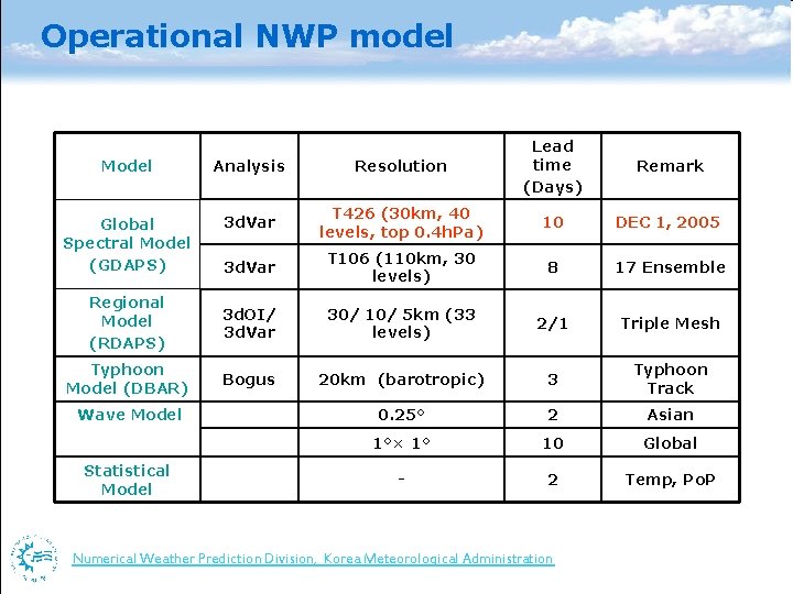
Operational NWP model Model Analysis Resolution Lead time (Days) Global Spectral Model (GDAPS) 3 d. Var T 426 (30 km, 40 levels, top 0. 4 h. Pa) 10 DEC 1, 2005 3 d. Var T 106 (110 km, 30 levels) 8 17 Ensemble Regional Model (RDAPS) 3 d. OI/ 3 d. Var 30/ 10/ 5 km (33 levels) 2/1 Triple Mesh Typhoon Model (DBAR) Bogus 20 km (barotropic) 3 Typhoon Track 0. 25° 2 Asian 1°× 1° 10 Global - 2 Temp, Po. P Wave Model Statistical Model Numerical Weather Prediction Division, Korea Meteorological Administration Remark Numerical Weather Prediction

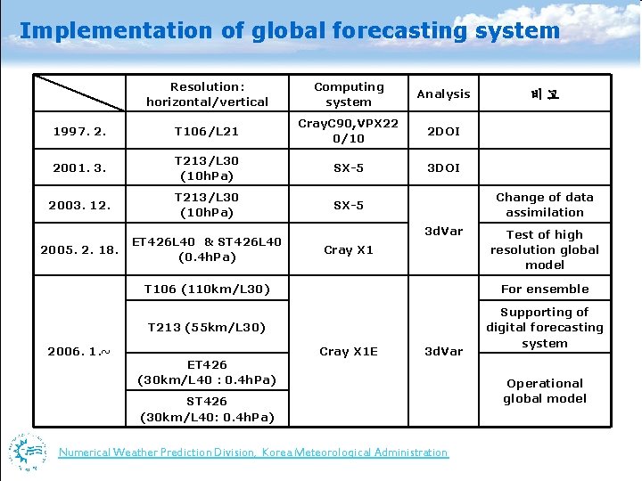
Implementation of global forecasting system Resolution: horizontal/vertical Computing system Analysis 1997. 2. T 106/L 21 Cray. C 90, VPX 22 0/10 2 DOI 2001. 3. T 213/L 30 (10 h. Pa) SX-5 3 DOI 2003. 12. T 213/L 30 (10 h. Pa) SX-5 2005. 2. 18. ET 426 L 40 & ST 426 L 40 (0. 4 h. Pa) 2006. 1. ~ 비고 Change of data assimilation 3 d. Var Cray X 1 Test of high resolution global model T 106 (110 km/L 30) For ensemble T 213 (55 km/L 30) Supporting of digital forecasting system ET 426 (30 km/L 40 : 0. 4 h. Pa) Cray X 1 E 3 d. Var Operational global model ST 426 (30 km/L 40: 0. 4 h. Pa) Numerical Weather Prediction Division, Korea Meteorological Administration Numerical Weather Prediction

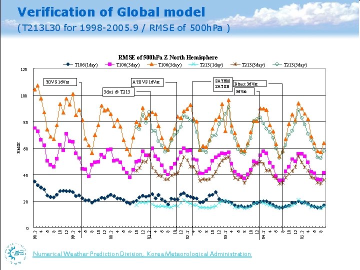
Verification of Global model (T 213 L 30 for 1998 -2005. 9 / RMSE of 500 h. Pa ) RMSE of 500 h. Pa Z North Hemisphere T 106(1 day) 120 T 106(3 day) TOVS 1 d. Var 100 T 106(5 day) ATOVS 1 d. Var 3 doi & T 213(1 day) T 213(3 day) SATEM SATOB T 213(5 day) Direct 3 d. Var 60 40 20 0 98. 2 4 6 8 10 12 99. 2 4 6 8 10 12 00. 2 4 6 8 10 12 01. 2 4 6 8 10 12 02. 2 4 6 8 10 12 03. 2 4 6 8 10 12 04. 2 4 6 8 10 12 05. 2 4 6 8 RMSE 80 Numerical Weather Prediction Division, Korea Meteorological Administration Numerical Weather Prediction

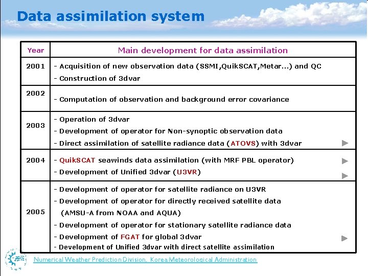
Data assimilation system Year 2001 Main development for data assimilation - Acquisition of new observation data (SSMI, Quik. SCAT, Metar…) and QC - Construction of 3 dvar 2002 2003 - Computation of observation and background error covariance - Operation of 3 dvar - Development of operator for Non-synoptic observation data - Direct assimilation of satellite radiance data (ATOVS) with 3 dvar 2004 - Quik. SCAT seawinds data assimilation (with MRF PBL operator) - Development of Unified 3 dvar (U 3 VR) - Development of operator for satellite radiance on U 3 VR - Development of operator for directly received satellite data 2005 (AMSU-A from NOAA and AQUA) - Development of operator for stationary satellite radiance data - Development of FGAT for global 3 dvar - Development of Unified 3 dvar with direct satellite assimilation Numerical Weather Prediction Division, Korea Meteorological Administration Numerical Weather Prediction

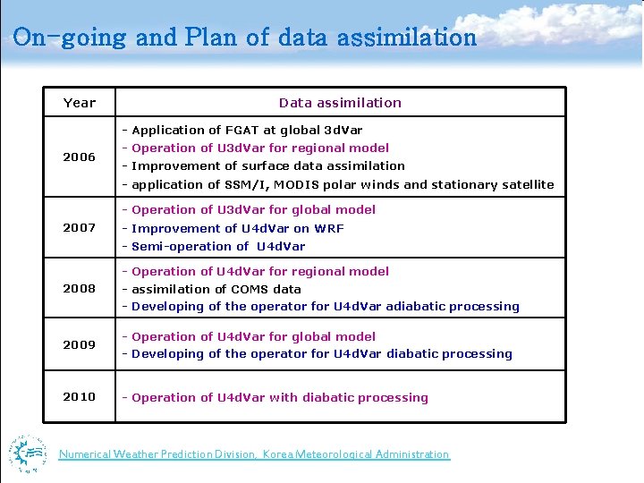
On-going and Plan of data assimilation Year Data assimilation - Application of FGAT at global 3 d. Var 2006 - Operation of U 3 d. Var for regional model - Improvement of surface data assimilation - application of SSM/I, MODIS polar winds and stationary satellite - Operation of U 3 d. Var for global model 2007 - Improvement of U 4 d. Var on WRF - Semi-operation of U 4 d. Var - Operation of U 4 d. Var for regional model 2008 - assimilation of COMS data - Developing of the operator for U 4 d. Var adiabatic processing 2009 - Operation of U 4 d. Var for global model - Developing of the operator for U 4 d. Var diabatic processing 2010 - Operation of U 4 d. Var with diabatic processing Numerical Weather Prediction Division, Korea Meteorological Administration Numerical Weather Prediction

Thank you! Numerical Weather Prediction Division, Korea Meteorological Administration Numerical Weather Prediction

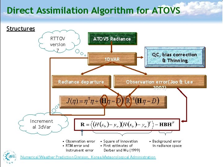
Direct Assimilation Algorithm for ATOVS Structures RTTOV version 7 ATOVS Radiance QC, bias correction & Thinning 1 DVAR Radiance departure Observation error(Joo & Lee 2002) Increment al 3 d. Var • Observation error • RTM error and instrument error • Square of innovation • First estimates of Derber and Wu (1999) • Background error in radiance space Numerical Weather Prediction Division, Korea Meteorological Administration Numerical Weather Prediction

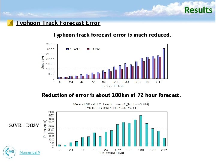
Results Typhoon Track Forecast Error Typhoon track forecast error is much reduced. Reduction of error is about 200 km at 72 hour forecast. G 3 VR – DG 3 V Numerical Weather Prediction Division, Korea Meteorological Administration Numerical Weather Prediction

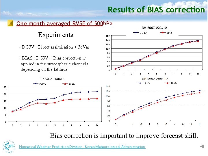
Results of BIAS correction One month averaged RMSE of 500 h. Pa Experiments NH 500 Z 200412 DG 3 V BIAS 160 140 120 • DG 3 V : Direct assimilation + 3 d. Var 100 80 • BIAS : DG 3 V + Bias correction is applied in the stratospheric channels depending on the latitude 60 40 20 0 0 1 2 3 4 5 6 7 8 9 10 TR 500 Z 200412 DG 3 V BIAS 25 20 15 10 5 0 0 1 2 3 4 5 6 7 8 9 10 Bias correction is important to improve forecast skill. Numerical Weather Prediction Division, Korea Meteorological Administration Numerical Weather Prediction

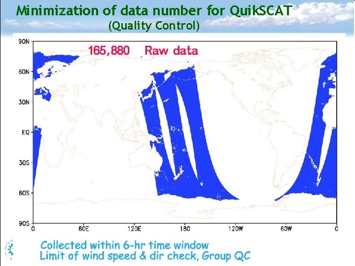
Minimization of data number for Quik. SCAT (Quality Control) Numerical Weather Prediction Division, Korea Meteorological Administration Numerical Weather Prediction

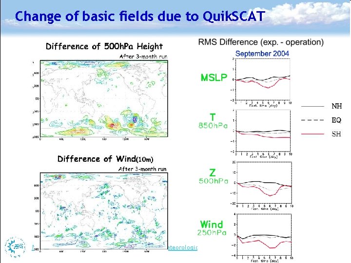
Change of basic fields due to Quik. SCAT Numerical Weather Prediction Division, Korea Meteorological Administration Numerical Weather Prediction

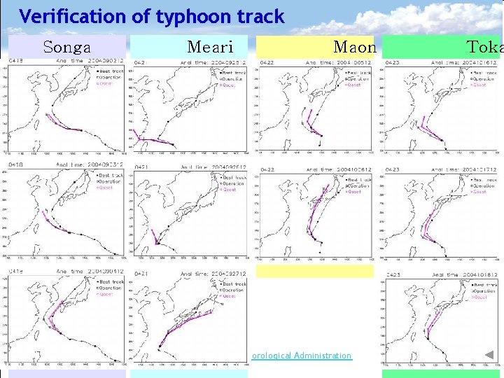
Verification of typhoon track Songa Meari Maon Numerical Weather Prediction Division, Korea Meteorological Administration Toka Numerical Weather Prediction

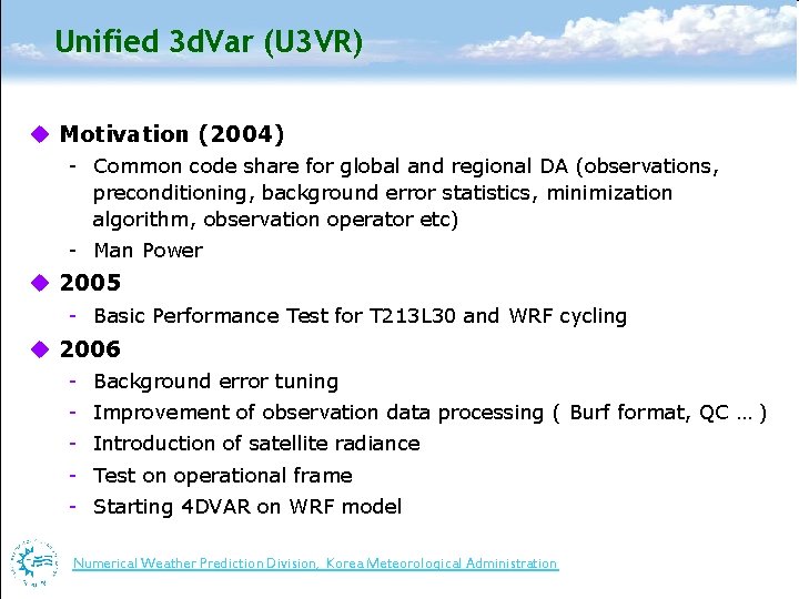
Unified 3 d. Var (U 3 VR) u Motivation (2004) - Common code share for global and regional DA (observations, preconditioning, background error statistics, minimization algorithm, observation operator etc) - Man Power u 2005 - Basic Performance Test for T 213 L 30 and WRF cycling u 2006 - Background error tuning - Improvement of observation data processing ( Burf format, QC … ) - Introduction of satellite radiance - Test on operational frame - Starting 4 DVAR on WRF model Numerical Weather Prediction Division, Korea Meteorological Administration Numerical Weather Prediction

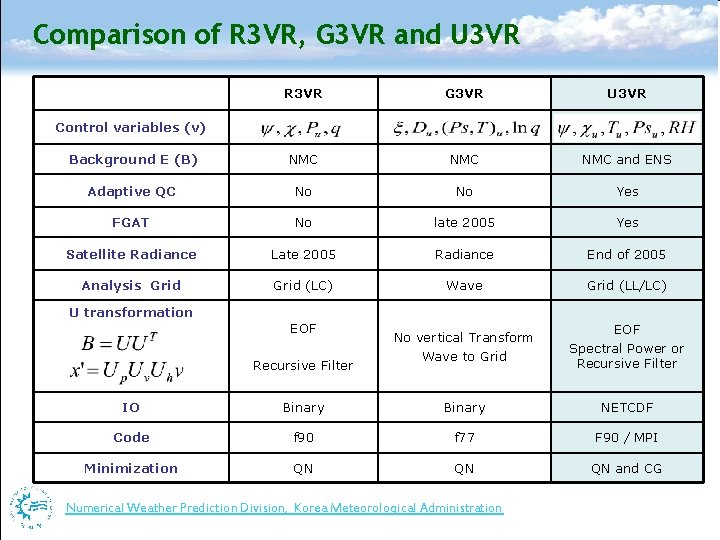
Comparison of R 3 VR, G 3 VR and U 3 VR R 3 VR G 3 VR U 3 VR Background E (B) NMC NMC and ENS Adaptive QC No No Yes FGAT No late 2005 Yes Satellite Radiance Late 2005 Radiance End of 2005 Analysis Grid (LC) Wave Grid (LL/LC) No vertical Transform Wave to Grid EOF Spectral Power or Recursive Filter Control variables (v) U transformation EOF Recursive Filter IO Binary NETCDF Code f 90 f 77 F 90 / MPI Minimization QN QN QN and CG Numerical Weather Prediction Division, Korea Meteorological Administration Numerical Weather Prediction

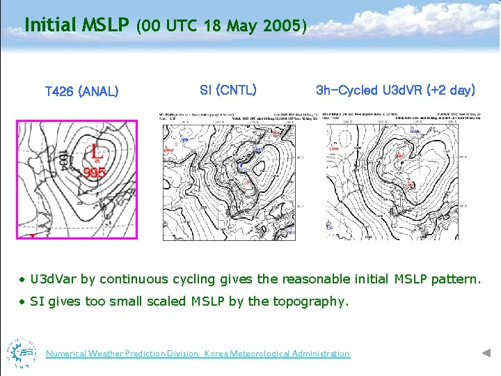
Initial MSLP (00 UTC 18 May 2005) T 426 (ANAL) SI (CNTL) 3 h-Cycled U 3 d. VR (+2 day) • U 3 d. Var by continuous cycling gives the reasonable initial MSLP pattern. • SI gives too small scaled MSLP by the topography. Numerical Weather Prediction Division, Korea Meteorological Administration Numerical Weather Prediction

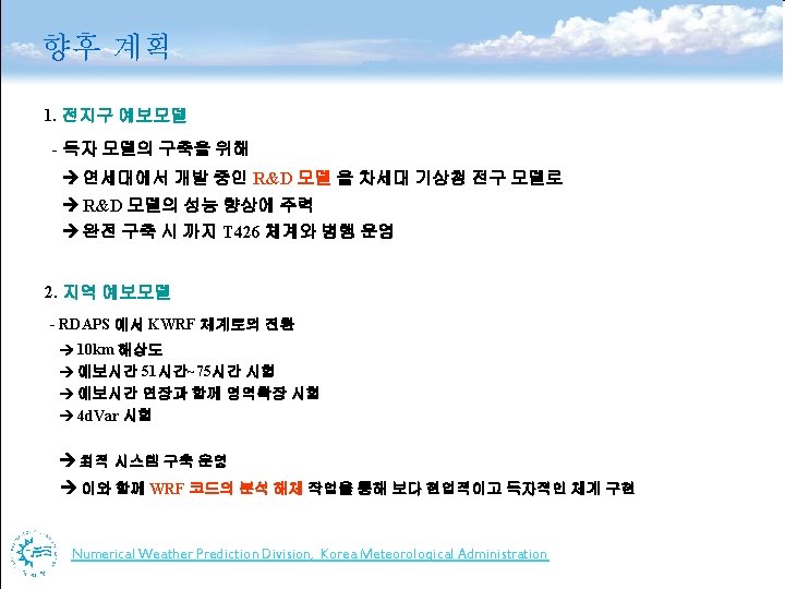
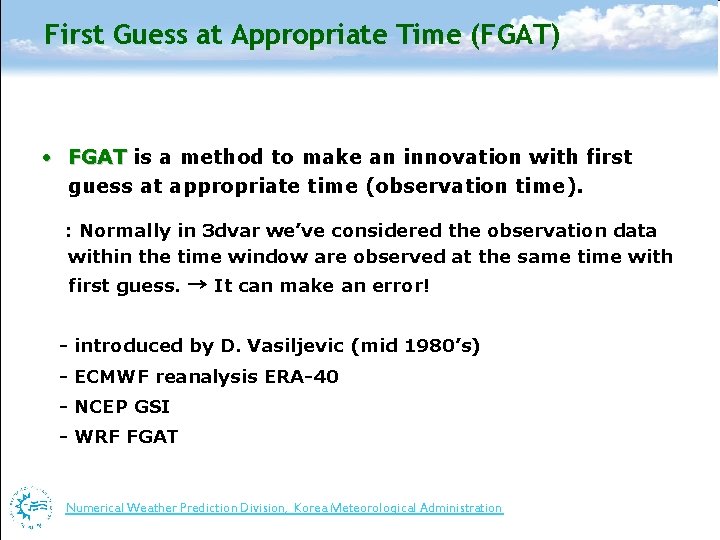
First Guess at Appropriate Time (FGAT) • FGAT is a method to make an innovation with first guess at appropriate time (observation time). : Normally in 3 dvar we’ve considered the observation data within the time window are observed at the same time with first guess. → It can make an error! - introduced by D. Vasiljevic (mid 1980’s) - ECMWF reanalysis ERA-40 - NCEP GSI - WRF FGAT Numerical Weather Prediction Division, Korea Meteorological Administration Numerical Weather Prediction

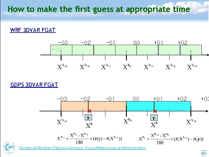
How to make the first guess at appropriate time WRF 3 DVAR FGAT -03 +03 – 02 – 01 00 +01 +02 GDPS 3 DVAR FGAT -03 × × y y Numerical Weather Prediction Division, Korea Meteorological Administration Numerical Weather Prediction +03

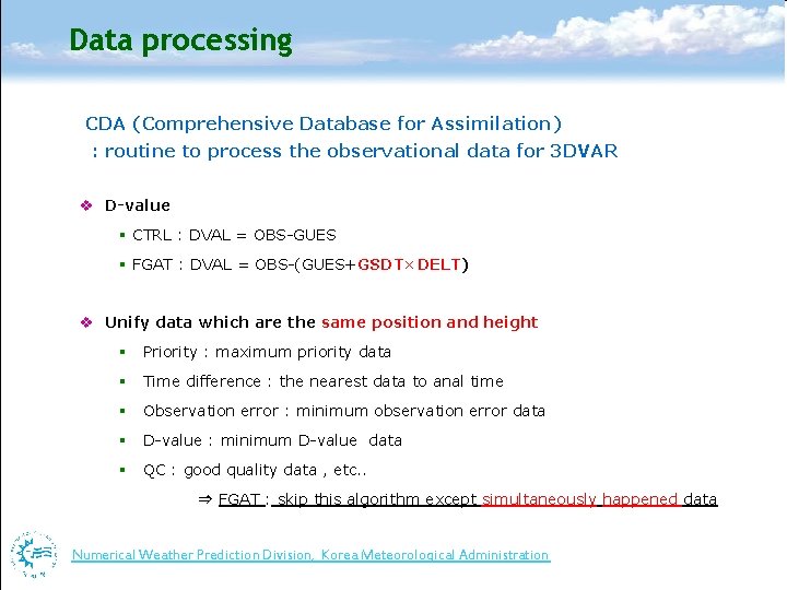
Data processing CDA (Comprehensive Database for Assimilation) : routine to process the observational data for 3 DVAR v D-value § CTRL : DVAL = OBS-GUES § FGAT : DVAL = OBS-(GUES+GSDT×DELT) v Unify data which are the same position and height § Priority : maximum priority data § Time difference : the nearest data to anal time § Observation error : minimum observation error data § D-value : minimum D-value data § QC : good quality data , etc. . ⇒ FGAT : skip this algorithm except simultaneously happened data Numerical Weather Prediction Division, Korea Meteorological Administration Numerical Weather Prediction

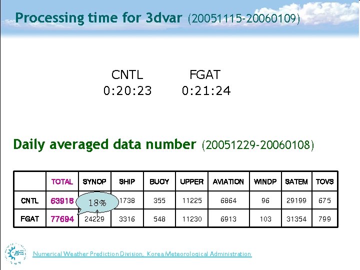
Processing time for 3 dvar (20051115 -20060109) CNTL 0: 23 FGAT 0: 21: 24 Daily averaged data number (20051229 -20060108) TOTAL SYNOP SHIP BUOY UPPER AVIATION WINDP SATEM TOVS CNTL 63918 14442 18% 1738 355 11225 6864 96 29199 675 FGAT 77694 24229 3316 548 11230 6913 103 31354 799 ↑ Numerical Weather Prediction Division, Korea Meteorological Administration Numerical Weather Prediction

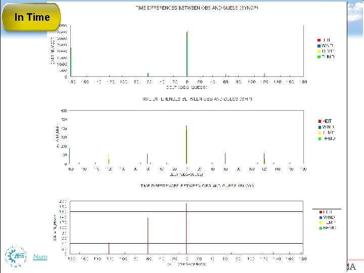
In Time Numerical Weather Prediction Division, Korea Meteorological Administration Numerical Weather. DIVISION/KMA Prediction NUMERICAL WEATHER PREDICTION

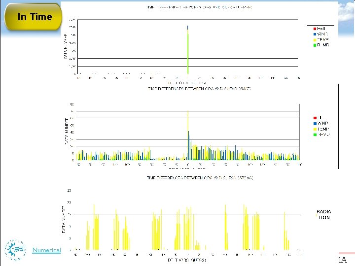
In Time RADIA TION Numerical Weather Prediction Division, Korea Meteorological Administration Numerical Weather. DIVISION/KMA Prediction NUMERICAL WEATHER PREDICTION

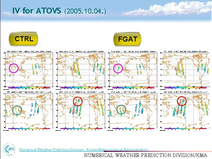
IV for ATOVS (2005. 10. 04. ) CTRL FGAT Numerical Weather Prediction Division, Korea Meteorological Administration Numerical Weather. DIVISION/KMA Prediction NUMERICAL WEATHER PREDICTION

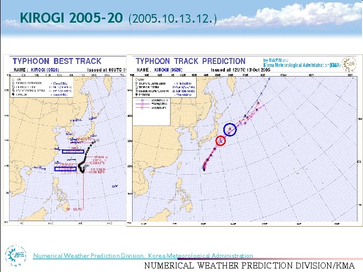
KIROGI 2005 -20 (2005. 10. 13. 12. ) Numerical Weather Prediction Division, Korea Meteorological Administration Numerical Weather. DIVISION/KMA Prediction NUMERICAL WEATHER PREDICTION

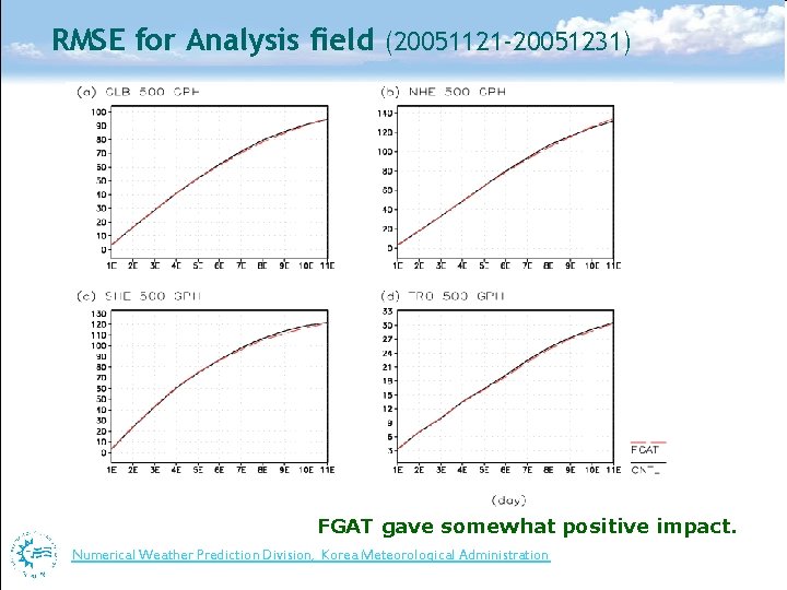
RMSE for Analysis field (20051121 -20051231) FGAT gave somewhat positive impact. Numerical Weather Prediction Division, Korea Meteorological Administration Numerical Weather Prediction

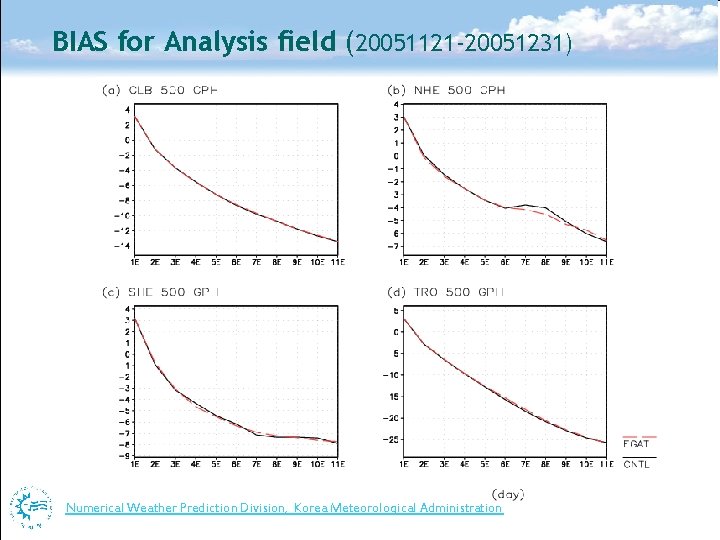
BIAS for Analysis field (20051121 -20051231) Numerical Weather Prediction Division, Korea Meteorological Administration Numerical Weather Prediction

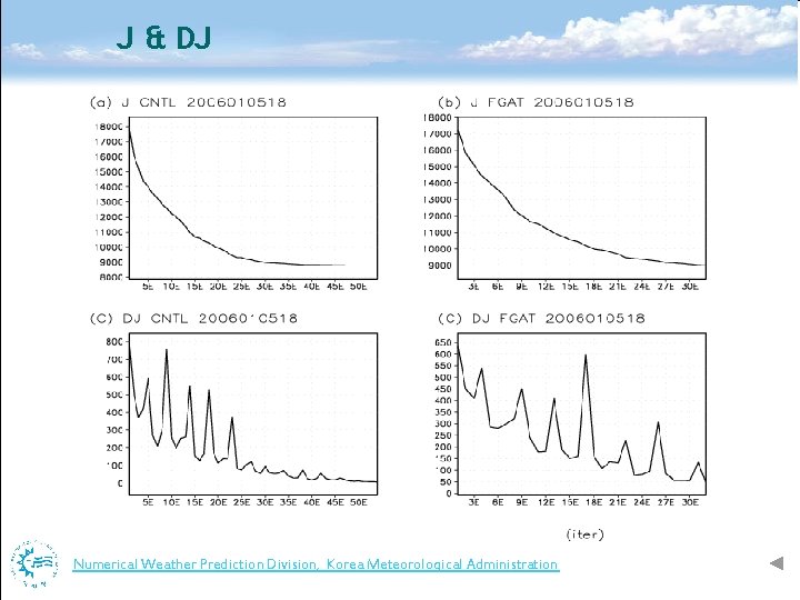
J & DJ Numerical Weather Prediction Division, Korea Meteorological Administration Numerical Weather Prediction

Numerical Weather Prediction Division, Korea Meteorological Administration Numerical Weather Prediction

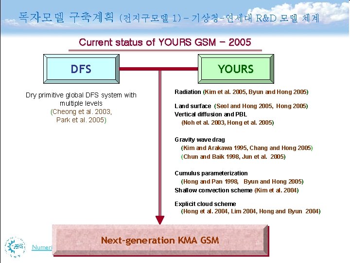
독자모델 구축계획 (전지구모델 1) – 기상청-연세대 R&D 모델 체계 Current status of YOURS GSM - 2005 DFS Dry primitive global DFS system with multiple levels (Cheong et al. 2003, Park et al. 2005) YOURS Radiation (Kim et al. 2005, Byun and Hong 2005) Land surface (Seol and Hong 2005, Hong 2005) Vertical diffusion and PBL (Noh et al. 2003, Hong et al. 2005) Gravity wave drag (Kim and Arakawa 1995, Chang and Hong 2005) (Chun and Baik 1998, Jun et al. 2005) Cumulus parameterization (Hong and Pan 1998, Byun and Hong 2005) Shallow convection scheme (Kim et al. 2004) Explicit cloud scheme (Hong et al. 2004, Lim 2004, Hong and Byun 2004) Next-generation KMA GSM Numerical Weather Prediction Division, Korea Meteorological Administration Numerical Weather Prediction

독자모델 구축계획 (전지구모델 2) – 기상청-연세대 R&D 모델 역학체계 Numerical Weather Prediction Division, Korea Meteorological Administration Numerical Weather Prediction


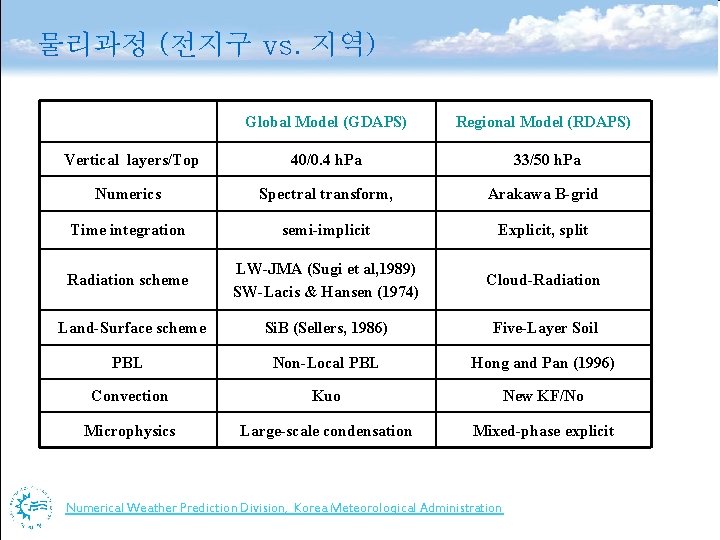
물리과정 (전지구 vs. 지역) Global Model (GDAPS) Regional Model (RDAPS) Vertical layers/Top 40/0. 4 h. Pa 33/50 h. Pa Numerics Spectral transform, Arakawa B-grid Time integration semi-implicit Explicit, split Radiation scheme LW-JMA (Sugi et al, 1989) SW-Lacis & Hansen (1974) Cloud-Radiation Land-Surface scheme Si. B (Sellers, 1986) Five-Layer Soil PBL Non-Local PBL Hong and Pan (1996) Convection Kuo New KF/No Microphysics Large-scale condensation Mixed-phase explicit Numerical Weather Prediction Division, Korea Meteorological Administration Numerical Weather Prediction
