Intro to the Middle East What to look


 Look at pg 549 at the map. 2. ) Look")


- Slides: 19
Intro to the Middle East
What to look for in the unit: • Geographic factors including scarcity of water have influenced cultures of Middle East. • Location has made the Middle East a meeting ground for people and ideas. • Ancient civilizations developed in the Tigris-Euphrates and Nile Valley. • The Middle East is the birthplace of Judaism, Christianity and Islam.
What is the Middle East? • Europeans invented the term to describe the area between Europe and Asia • It is actually in the Southwestern part of Asia but called the “Middle East” • The Middle East often includes North Africa as well – Uses the Arabic language and the Islamic religion as well • Grouped together this area is called the “Muslim World”
Crossroads of the World • Middle East is the connecting point for three different continents: – Africa – Asia – Europe • Connection of major trade routes both by both land sea • Caravans from India and China bring goods to markets in the Middle East
Trade Routes 1. ) Look at pg 549 at the map. 2. ) Look at pg 552 at the map.
Cultural Diffusion in the Area • Thousands of years have seen people, traders and conquerors cross through the Middle East – Brought ideas, inventions and achievements • Examples: – Iron making – The alphabet – Judaism, Christianity and Islam – Arabic numerals from India (traveled through the Middle East) – Lateen sail from Southeast Asia (traveled through the Middle East)
Strategic Location on the Earth’s Surface • Important in the world today for military and economic reasons (strategic value) • Command vital (important) sea routes • Controls large amounts of petroleum (oil) • Question to Ponder: – Why is it important to control sea routes, both in the past and today? I have no idea!
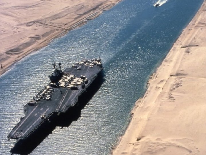
Egypt and the Suez Canal • Links the Mediterranean Sea and the Red Sea – Allows travel to the Indian Ocean • Major route for shipping and trade • Built by the French and controlled by Egypt • One of the most important canals in history
Turkey and the Bosporus and Dardanelles Straits • Two important straits controlled by the country of Turkey • Strait- a narrow passage of water connecting two large bodies of water. • Links the Black and Aegean Seas to one another • Called the “Turkish Straits” • Strait of Hormuz- at the mouth of the Persian Gulf – Major route for the shipping and trade of oil all over the world
Dardanelles Strait Bosporus Strait
Major Regions of the Middle East Northern Tier Goes across Turkey and Iran See map on page 552 Mountains and Plateaus Anatolian Plateau- West – Fertile soil and bigger population – Site of the Ottoman Empire • Iranian Plateau- East – Drier area with mountains and a small population – Site of the Persian Empire • • • Arabian Peninsula • Large Plateau about 1/3 the size of the US • The peninsula is mostly desert area • Some fertile areas on the southern coast • People live near Oasisfertile desert area that has enough water to support life • Large oil reserves • Birthplace of Islam and the holy city of Mecca
Major Regions of the Middle East • Fertile Crescent • Runs along the Tigris and Euphrates Rivers • Rich soil and lots of water allow for agriculture • Site of one of the earliest civilizations • Mesopotamia – “land between the rivers” • Few natural barriers and therefore many invaders • Nile Valley • Located in the Northern Part of Africa • More protected than Mesopotamia – Deserts protect the East and West of the Nile Valley – The Nile River floods on a predictable schedule – Tigris and Euphrates River flood irregularly
Major Regions of the Middle East • The Maghreb • Includes- Algeria, Tunisia and Morocco • Means- “Western Isle” in Arabic • Sahara Desert and Atlas Mountains are here • Major crossroads area for trade between West Africa, Europe and the Middle East
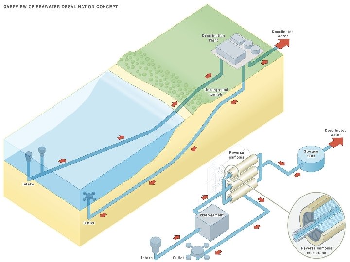
Climate and Resources • Climate controls where the people live in the Middle East • People live along the coasts and in the river valleys • Less than 10% of the land gets enough water to farm with • Need for irrigation systems: – Ancient Egyptians used a Shaduf- water hoist to move water from ditches and canals to fields • Utilizing desalination plants – Turn water from the oceans and seas into fresh water (Look at page 613 and answer the questions)
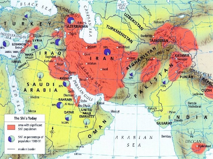
Peoples • Home to many different peoples with many languages, religions and traditions • Major Languages: – Arabic, Turkish, Hebrew, Kurdish, Persian, Greek & Armenian • Religions: – Islam, Christianity, Judaism • 19 Different Countries • 350 million people in the Middle East
Peoples • Ethnic Diversity – Arabs are the majority group in the area – Conquered peoples became Arabs – Arab- defined as anyone whose native language is Arabic • Other Groups: – Turks, Iranians and Kurds • All groups have their own languages and traditions • Religious Diversity – Islam is the major religion in the area – Muslim- one who practices Islam • Christians – Coptic, Greek Orthodox and Maronite • Judaism – Most ancient of the religions in the area – Israel- the majority of the people are Jewish