INTERPRETATION OF LARGE SCALE CIRRUS PATTERNS LARGE SCALE

- Slides: 27

INTERPRETATION OF LARGE SCALE CIRRUS PATTERNS

LARGE SCALE CIRRUS PATTERNS Large scale Ci cloud formations and dry zone boundaries are useful for locating: Axes of jet streams Thermal and upper ridges Upper anticyclones Upper level turbulence

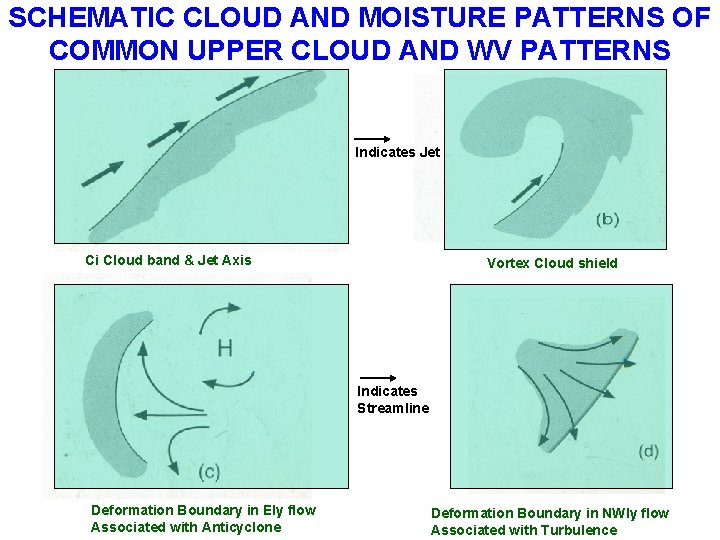
SCHEMATIC CLOUD AND MOISTURE PATTERNS OF COMMON UPPER CLOUD AND WV PATTERNS Indicates Jet Ci Cloud band & Jet Axis Vortex Cloud shield Indicates Streamline Deformation Boundary in Ely flow Associated with Anticyclone Deformation Boundary in NWly flow Associated with Turbulence

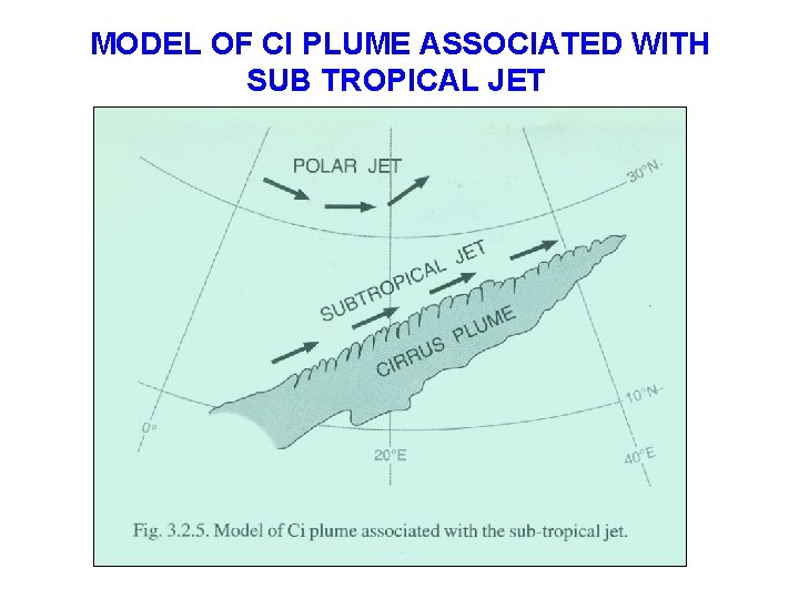
MODEL OF CI PLUME ASSOCIATED WITH SUB TROPICAL JET

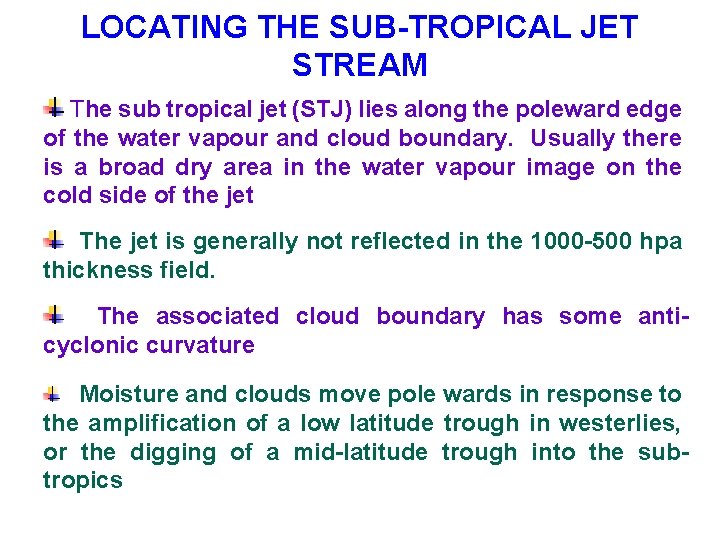
LOCATING THE SUB-TROPICAL JET STREAM The sub tropical jet (STJ) lies along the poleward edge of the water vapour and cloud boundary. Usually there is a broad dry area in the water vapour image on the cold side of the jet The jet is generally not reflected in the 1000 -500 hpa thickness field. The associated cloud boundary has some anticyclonic curvature Moisture and clouds move pole wards in response to the amplification of a low latitude trough in westerlies, or the digging of a mid-latitude trough into the subtropics

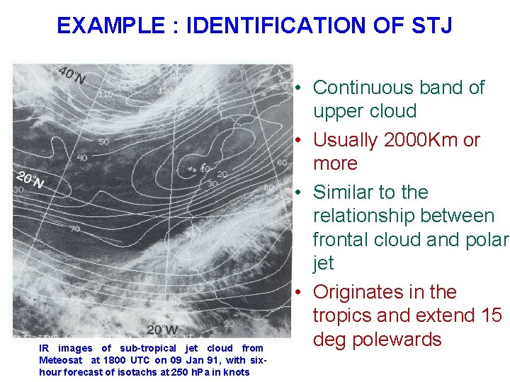
EXAMPLE : IDENTIFICATION OF STJ IR images of sub-tropical jet cloud from Meteosat at 1800 UTC on 09 Jan 91, with sixhour forecast of isotachs at 250 h. Pa in knots • Continuous band of upper cloud • Usually 2000 Km or more • Similar to the relationship between frontal cloud and polar jet • Originates in the tropics and extend 15 deg polewards

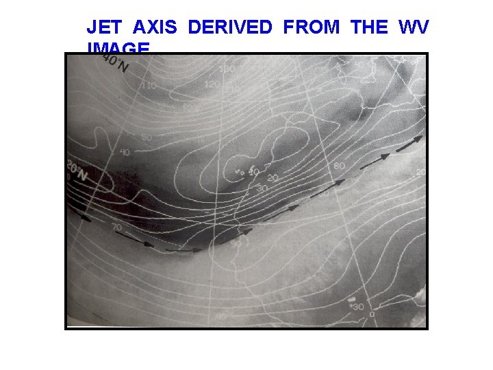
JET AXIS DERIVED FROM THE WV IMAGE

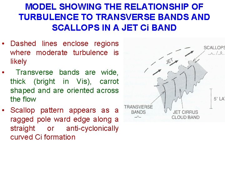
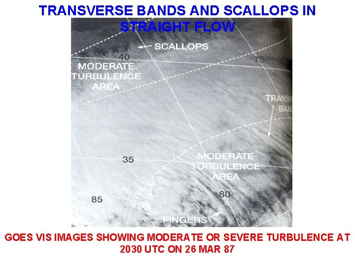
MODEL SHOWING THE RELATIONSHIP OF TURBULENCE TO TRANSVERSE BANDS AND SCALLOPS IN A JET Ci BAND • Dashed lines enclose regions where moderate turbulence is likely • Transverse bands are wide, thick (bright in Vis), carrot shaped and are oriented across the flow • Scallop pattern appears as a ragged pole ward edge along a straight or anti-cyclonically curved Ci formation

LOCATING TURBULENCE ASSOCIATED WITH JET STREAMS • Empirical studies show that certain Ci boundaries and cloud patterns are often associated with moderate or severe upper level turbulence • Turbulence is identified with Jet streams accompanied by strong temperature gradients, shears, deformation in the upper flow, atmospheric waves and instability • Turbulence is usually confined to within 3° latitude of the cloud or moisture edge • Transverse bands, oriented across the direction of the upper wind flow, occur within both straight and anticyclonically curved jet Ci shields. • Transverse Ci bands, Ci scallops and billows are patterns, which may indicate moderate or possibly severe turbulence at the cruising altitude of jet aircraft

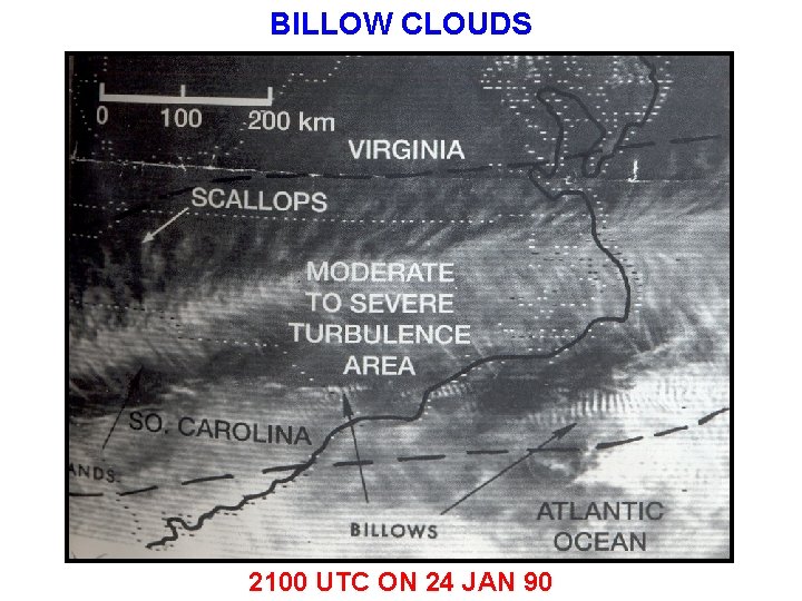
LOCATING TURBULENCE ASSOCIATED WITH JET STREAMS • Billow cloud patterns occur in strong wind shear and have a wavelength of a few kilometers • They are too small to depict in the model • The patterns are not terrain-related, but translate and are transitory • Large scale billows with a wavelength of 5 km or more nearly always indicates the presence of severe turbulence. Examples of these features are shown in imageries

TRANSVERSE BANDS AND SCALLOPS IN STRAIGHT FLOW GOES VIS IMAGES SHOWING MODERATE OR SEVERE TURBULENCE AT 2030 UTC ON 26 MAR 87

BILLOW CLOUDS 2100 UTC ON 24 JAN 90

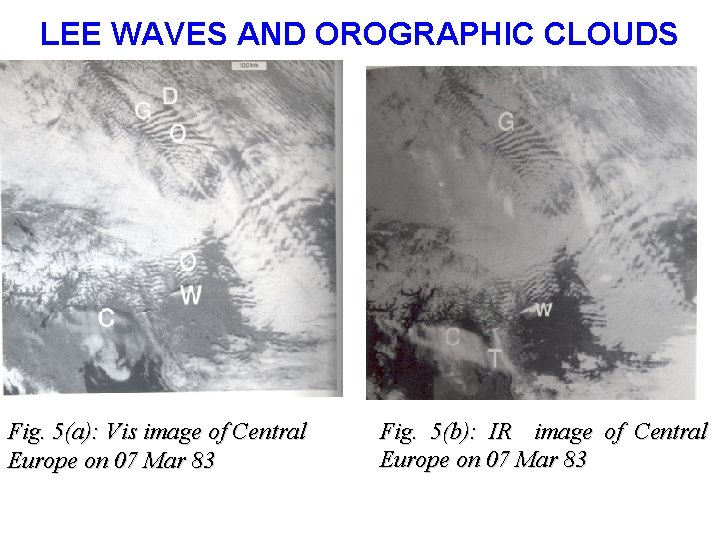
LEE WAVES AND OROGRAPHIC CLOUDS Fig. 5(a): Vis image of Central Europe on 07 Mar 83 Fig. 5(b): IR image of Central Europe on 07 Mar 83

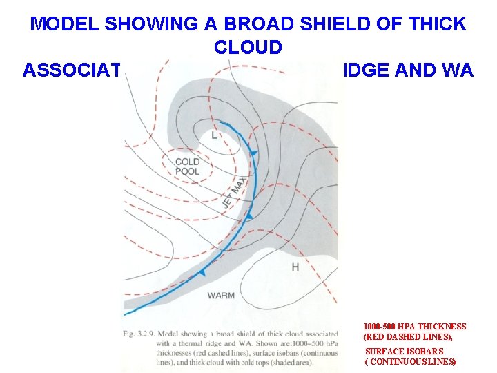
MODEL SHOWING A BROAD SHIELD OF THICK CLOUD ASSOCIATED WITH A THERMAL RIDGE AND WA 1000 -500 HPA THICKNESS (RED DASHED LINES), SURFACE ISOBARS ( CONTINUOUS LINES)

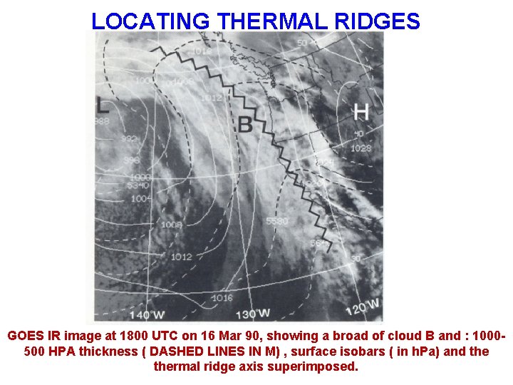
LOCATING THERMAL RIDGES • Solid, bright shields usually reflect a well- defined ridge • Ragged or fragmented shields usually reflect a weak, low amplitude thickness ridge • The model shows a broad cloud shield (over 500 km wide) around a high amplitude thermal ridge • The imagery next shown is an example of a broad shield of cloud B and the associated thickness pattern.

LOCATING THERMAL RIDGES GOES IR image at 1800 UTC on 16 Mar 90, showing a broad of cloud B and : 1000500 HPA thickness ( DASHED LINES IN M) , surface isobars ( in h. Pa) and thermal ridge axis superimposed.

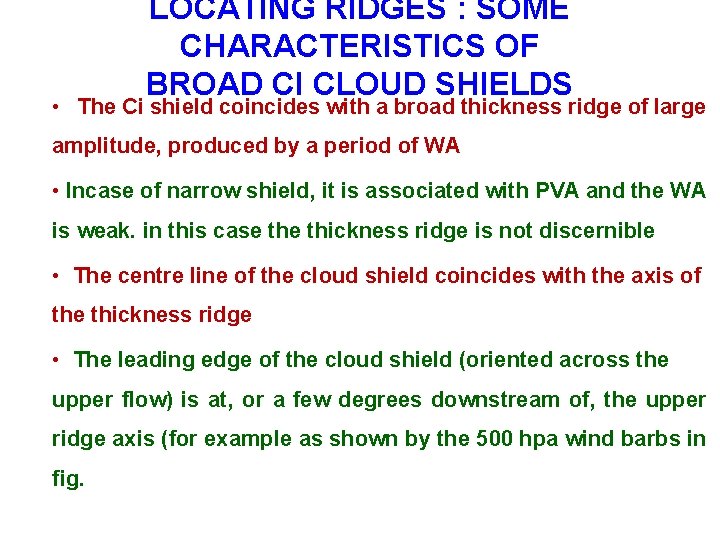
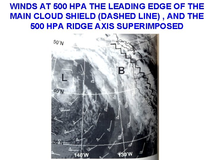
LOCATING RIDGES : SOME CHARACTERISTICS OF BROAD CI CLOUD SHIELDS • The Ci shield coincides with a broad thickness ridge of large amplitude, produced by a period of WA • Incase of narrow shield, it is associated with PVA and the WA is weak. in this case thickness ridge is not discernible • The centre line of the cloud shield coincides with the axis of the thickness ridge • The leading edge of the cloud shield (oriented across the upper flow) is at, or a few degrees downstream of, the upper ridge axis (for example as shown by the 500 hpa wind barbs in fig.

WINDS AT 500 HPA THE LEADING EDGE OF THE MAIN CLOUD SHIELD (DASHED LINE) , AND THE 500 HPA RIDGE AXIS SUPERIMPOSED

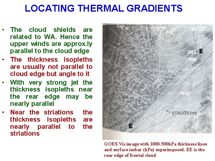
LOCATING THERMAL GRADIENTS • The cloud shields are related to WA. Hence the upper winds are approx. ly parallel to the cloud edge • The thickness isopleths are usually not parallel to cloud edge but angle to it • With very strong jet the thickness isopleths near the rear edge may be nearly parallel • Near the striations the thickness isopleths are nearly parallel to the striations 992 E 996 1012 E GOES Vis image with 1000 -500 h. Pa thickness lines and surface isobar (h. Pa) superimposed. EE is the rear edge of frontal cloud

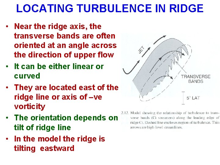
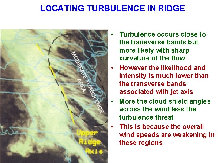
LOCATING TURBULENCE IN RIDGE • Near the ridge axis, the transverse bands are often oriented at an angle across the direction of upper flow • It can be either linear or curved • They are located east of the ridge line or axis of –ve vorticity • The orientation depends on tilt of ridge line • In the model the ridge is tilting eastward

LOCATING TURBULENCE IN RIDGE • Turbulence occurs close to the transverse bands but more likely with sharp curvature of the flow • However the likelihood and intensity is much lower than the transverse bands associated with jet axis • More the cloud shield angles across the wind less the turbulence threat • This is because the overall wind speeds are weakening in these regions

LOCATING UPPER LEVEL ANTICYCLONE

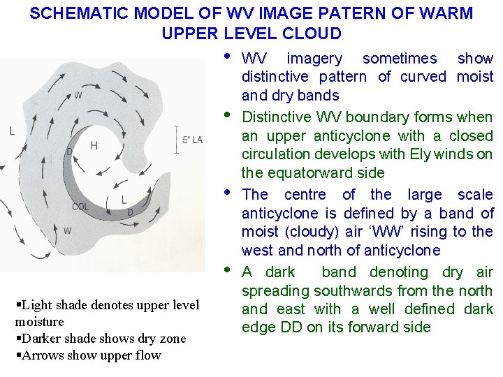
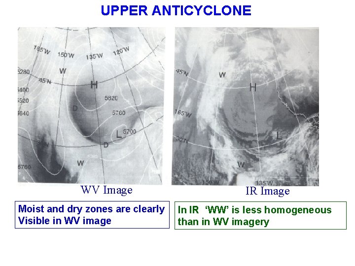
SCHEMATIC MODEL OF WV IMAGE PATERN OF WARM UPPER LEVEL CLOUD • • §Light shade denotes upper level moisture §Darker shade shows dry zone §Arrows show upper flow WV imagery sometimes show distinctive pattern of curved moist and dry bands Distinctive WV boundary forms when an upper anticyclone with a closed circulation develops with Ely winds on the equatorward side The centre of the large scale anticyclone is defined by a band of moist (cloudy) air ‘WW’ rising to the west and north of anticyclone A dark band denoting dry air spreading southwards from the north and east with a well defined dark edge DD on its forward side

UPPER ANTICYCLONE WV Image Moist and dry zones are clearly Visible in WV image IR Image In IR ‘WW’ is less homogeneous than in WV imagery

LOCATING TURBULENCE IN DEFORMATION ZONES

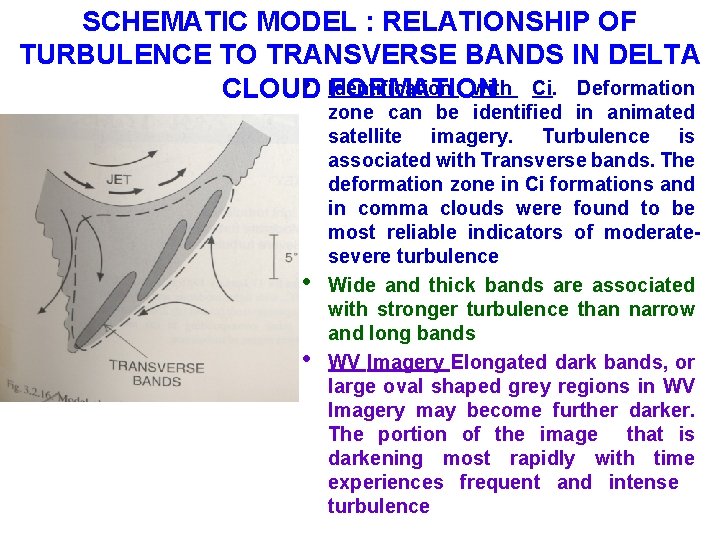
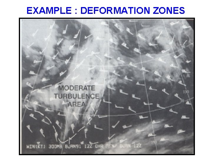
SCHEMATIC MODEL : RELATIONSHIP OF TURBULENCE TO TRANSVERSE BANDS IN DELTA • Identification with Ci. Deformation CLOUD FORMATION • • zone can be identified in animated satellite imagery. Turbulence is associated with Transverse bands. The deformation zone in Ci formations and in comma clouds were found to be most reliable indicators of moderatesevere turbulence Wide and thick bands are associated with stronger turbulence than narrow and long bands WV Imagery Elongated dark bands, or large oval shaped grey regions in WV Imagery may become further darker. The portion of the image that is darkening most rapidly with time experiences frequent and intense turbulence

EXAMPLE : DEFORMATION ZONES