INTERNATIONAL SATELLITE COMMUNICATIONS SYSTEM ISCS SUCESSOR TCPIP SYSTEM
 SUCESSOR TCP/IP SYSTEM Background - Status – Backup RA")
 GENERAL DESCRIPTION & PURPOSE The ISCS is composed")
 ØThe United States will continue to support ICAO/WMO")


 ØThe AOR portion of the successor ISCS will be centered")
 ØThe AOR portion of the successor ISCS will be centered")
 ØThe POR portion of ISCS will be centered around the")


- Slides: 19
INTERNATIONAL SATELLITE COMMUNICATIONS SYSTEM (ISCS) SUCESSOR TCP/IP SYSTEM Background - Status – Backup RA IV/WG-PIW-04/Doc. 5. 2(1) ISCS Status (13. X. 2004) Submitted by F. Branski, (USA)
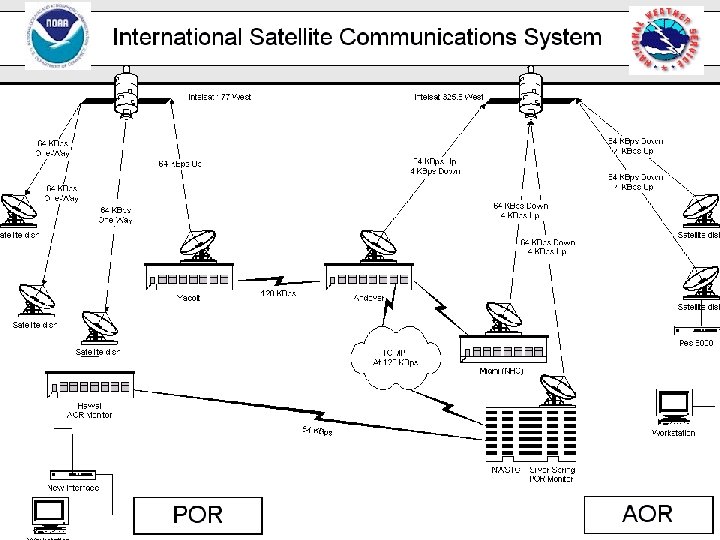
The International Satellite Communications System (ISCS) GENERAL DESCRIPTION & PURPOSE The ISCS is composed of two systems for data delivery via satellite communications. The first system is the World Area Forecast System (WAFS) in support of the International Civil Aviation Organization (ICAO) program for aviation data distribution. The WAFS broadcast makes globally available to aviation users the centrally produced aviation model forecast products of a World Area Forecast Center (WAFC) in global gridded binary form (WMO GRIB code), Alpha-numeric text, facsimile graphics ( T 4 -FAX format), and satellite imagery (GIF format) data types. T 4 FAX will be replaced by binary graphics (BUFR) data format beginning in 2004. The second part of the ISCS is the Region IV Meteorological Telecommunications Network (RMTN) satellite system which replaced the two WMO Region IV GTS regional communication networks of the Antilles Meteorological (ANMET) and Central America Meteorological (CEMET). The RMTN supports WMO GRIB, alpha-numeric text, and T 4 -FAX data types. T 4 FAX will be replaced by binary graphics (BUFR) data format beginning in 2004.
The International Satellite Communications System (ISCS) ØThe United States will continue to support ICAO/WMO requirements (as a servicing World Area Forecast Center (WAFC) and a Regional Telecommunication Hub (RTH) with the ISCS. ØThe global coverage will continue to span approximately from 105 degrees east longitude to 65 degrees east longitude (covering the Pacific Ocean, Atlantic Ocean, North America, Central America, South America, and the Caribbean). ØThe remainder of the world coverage will continue to be supported by the WAFC located in the United Kingdom through their satellite broadcast system called SADIS (which primarily covers the European, Asian, and African continents as well as the Indian Ocean).
ISCS - STATUS • • Terrestrial 128 Kbps data links between NWSTG and ISCS Andover hub Nine (9) IP sockets replaced previous six (6) X. 25 permanent virtual circuits (PVCs) Network supported both X. 25 and IP protocols until approximately 30 November 2004 or until the IP system is considered fully operational Network interface equipment installed at all sites • • • PD Receive network interface software distributed to all sites by MCI Six new 2 -way sites in POR 25 receive only sites (WAFS) haven’t acquired a TCP/IP capable workstation Planned Backup of ISCS at NWS backup Telecommunication Gateway currently under development U. K. Met Office Backup of ISCS Backup of U. K. Met Office
ISCS IP Socket Assignments Ø The socket assignment at the NWSTG is assigned as below, and reordered in the Andover, MA routers for transmission to the AOR and POR. Ø Socket – 1: AOR WAFS, WMO GRIB, Temp, Wind, & Humidity (Bulletins and charts) Ø Socket-2 AOR WAFS, Alphanumeric data messages Ø Socket 3 AOR WAFS, Graphical T 4 coded data. Ø Socket 4: RMTN-IV Gridded Binary (GRIB) code data, Ø Socket 5: GTS Alphanumeric data (primarily synoptic and text), Ø Socket 6: RMTN-IV Graphical data (analysis and significant weather). Ø Socket 7: POR WAFS, WMO GRIB, Temp, Wind, & Humidity (Bulletins and charts) Ø Socket 8: POR WAFS, Alphanumeric data messages Socket 9: POR WAFS, Graphical T 4 coded data.
ISCS Network Hub Configurations
ATLANTIC OCEAN REGION (AOR) ØThe AOR portion of the successor ISCS will be centered around the MCI shared Master Satellite Hub, in Andover, Maine. ØThe Master Satellite Hub will be linked via a 64 Kbps (128 Kbps bursting) terrestrial (redundant) circuit to the National Weather Service Telecommunications Gateway (NWSTG) in Silver Spring, Maryland. ØThe NWSTG will continue to serve as the central point of data entry into the ISCS. ØAll ISCS data originating at the NWSTG will be transmitted, using TCP/IP network protocol, over to the MCI Andover facility for broadcast to all ISCS AOR sites.
ATLANTIC OCEAN REGION (AOR) ØThe AOR portion of the successor ISCS will be centered around the World. Com shared Master Satellite Hub, in Andover, Maine. ØThe Master Satellite Hub will be linked via a 64 Kbps (128 Kbps bursting) terrestrial (redundant) circuit to the National Weather Service Telecommunications Gateway (NWSTG) in Silver Spring, Maryland. ØThe NWSTG will continue to serve as the central point of data entry into the ISCS. ØAll ISCS data originating at the NWSTG will be transmitted, using TCP/IP network protocol, over to the World. Com Andover facility for broadcast to all ISCS AOR sites.
PACIFIC OCEAN REGION (POR) ØThe POR portion of ISCS will be centered around the MCI shared Master Satellite Hub in Yacolt, Washington. ØThe Yacolt Master Satellite Hub will be linked via a 64 Kbps (128 Kbps bursting) terrestrial (redundant) circuit to the MCI shared Master Satellite Hub in Andover, Maine. ØAll ISCS WAFS data originating at the NWSTG will transmitted, using TCP/IP network protocol, to the Yacolt facility (via the Andover facility) for broadcast to all POR sites.
ISCS WAFS – Pacific Ocean Region
ISCS NETWORK – PACIFIC ISLANDS Remote Locations • Chuuk • Pohnpei • Kosrae • Majuro • Koror • Yap • Honolulu (upgrade to two-way) Notes: 1. Satellite based network with Hub located at MCI Earth Station, Yacolt, WA 2. Satellite network utilizes Intelsat 176 C-Band 3. Hub Antenna size 18 m 4. Remotes consist of 2. 4 m antennas
ISCS Two-Way Site Configuration IP Note: 1. Remote Terminal consists of a 2. 4 m C-Band Antenna and PES 8000 Indoor Unit 2. PES 8000 is configured with one (1) Turbo Port Card 3. Interface Card for NWS includes an Ethernet PLC and provides 10 Mb RJ 45 Connection
ISCS Receive-Only Site Configuration
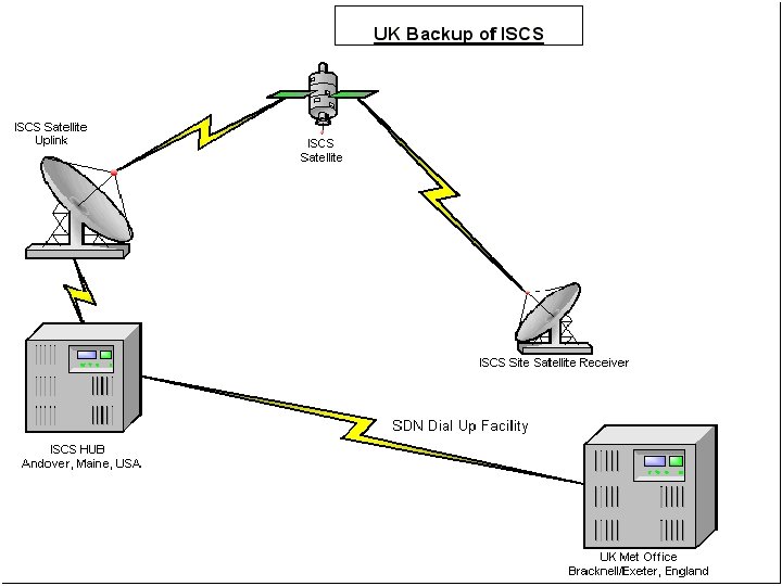
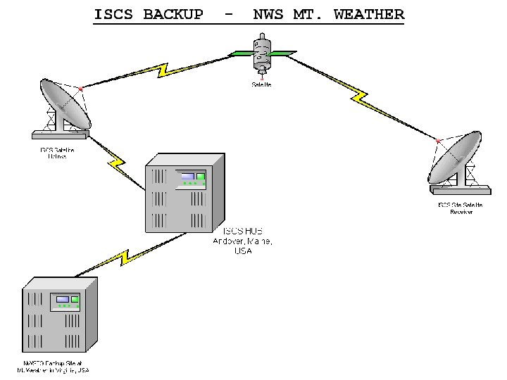
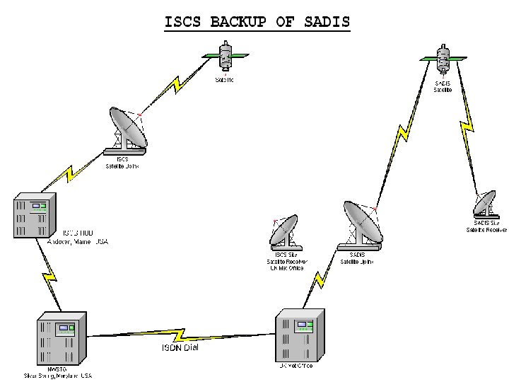
ISCS Backup Ø U. K. WAFC is the backup for the US WAFC product delivery via ISDN dialup connection to Andover Hub. Ø The ISCS Successor has increased the number of Backup options with multiple ISDN dialup connections between the Andover Hub, UK WAFC, the Aviation Weather Center (AWC) Kansas City, and planned for the NWS backup Telecommunication Gateway currently under development.
Customer Support • 24 -hour Helpdesk: Tel. +301 -713 -0902 • E-mail: toc. nwstg@noaa. gov • Hardware Problems: – VSAT: Contact MCI (donley. j. stocking@mci. com) – Workstation: Contact your workstation supplier. • Broadcast problems (e. g. missing products): contact the Helpdesk. • General problems: Contact Patrick Gillis at WAFC Silver Spring (+301 -713 -1743 ext. 104, E-mail patrick. gillis@noaa. gov).