International Hydrographic Organization IHO Capt Alberto Costa Neves
 Capt Alberto Costa Neves Assistant Director, IHO")
International Hydrographic Organization (IHO) Capt Alberto Costa Neves Assistant Director, IHO

OUTLINE Introduction n. Hydrography n. The IHO and Current Activities n. Conclusion n

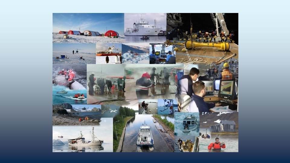
what is hydrography ? how is it done ? what do we do in Monaco ?

Hydrography is better known by a window called: NAUTICAL CHART but

Hydrography is …. NOT NAUTICAL CHARTING

Hydrography is …. - measuring and describing the physical features of oceans, seas, coastal areas, lakes and rivers for : - safety of navigation - protecting the marine environment - other marine activities including - economic development - security and defence - scientific research

Hydrography Involves The collection of hydrographic data n The production of nautical charts and publications n The dissemination of Maritime Safety Information (MSI) n

• Hydrographic surveying

• Li. DAR – Light Detection And Ranging

Calibration …. sound velocity • temperature • salinity • depth

Tides ….

Processing the data ….
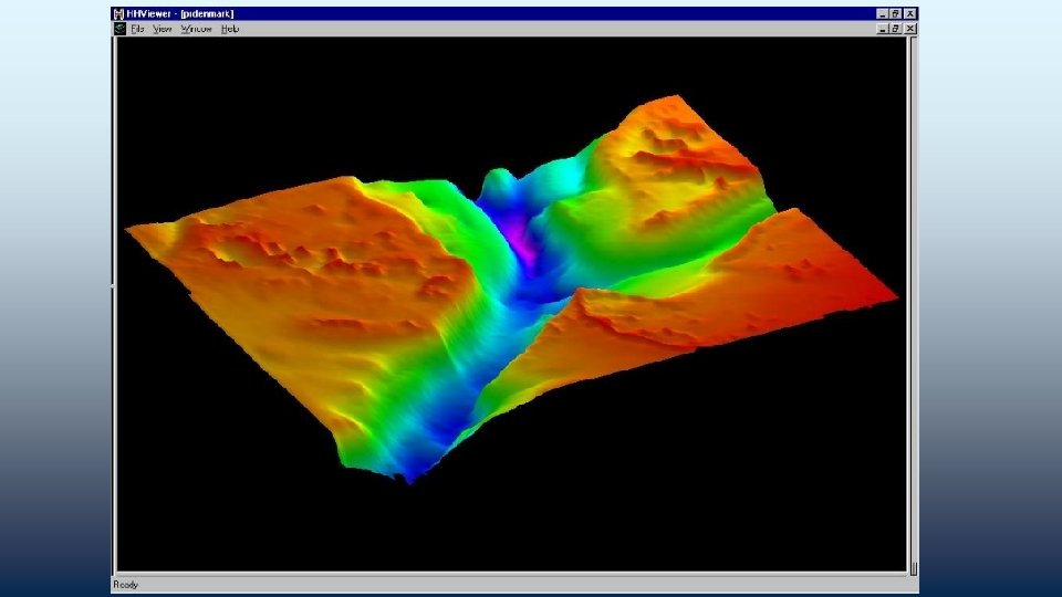

Making chart …. a

paper charts • electronic charts •

• • • tide tables sailing directions lists of lights and radio signals

Role of the IHO
 • • • intergovernmental consultative and technical organization")
INTERNATIONAL HYDROGRAPHIC ORGANIZATION ( IHO ) • • • intergovernmental consultative and technical organization established in 1921 to support safety of navigation and the protection of the marine environment

History of the IHO 1889 International Marine Congress, Washington 1908 International Congress of Navigation, St Petersburg 1912 International Maritime Conference, St Petersburg 1919 International Hydrographic Conference, London 1921 IHB established by 24 nations in Monaco 1970 International Convention: established 2005 Protocol of Amendments to the IHO Convention 2016 Revised IHO Convention entered into force on 8 November 2019 -2021 Celebrations of the 100 th anniversary

IHO Programmes n n raising awareness on importance of hydrography setting international standards and guidelines coordination of regional and global nautical charting services hydrographic capacity building

The IHO Secretariat Monaco

IHO STAFF IHO Secretariat 20 Personnel • 3 Directors-The Directing Committee • 5 Professional Assistants • 2 + 1 Translators • 9 Supporting Staff + 3 Secondement Staff

IHO MANAGEMENT TEAM

Activities of the IHO Secretariat n n n n Secretariat role 15 technical standards 10 associated guidelines 18 other publications Direct support to 40 bodies (Committees, WGs and RHCs) Conference organisation External representation bi-lingual website

IHO • • • 89 Member States Recognized competent authority at UN General Assembly and IMO Active liaison with: UN-IMO, UN-GGIM, UN-DOALOS, UNESCO-IOC, UN-WMO, EC, GEO, IALA, ISO, FIG, ICA, CIRM, ICS, …. .

IHO Member States – 2017 ~ 150 coastal States IMO: 170 UNESCO IOC: 145 IHO: 87

IHO Member States – 2017 MEMBERSHIP IMO: 174 IOC: 145 IHO: 89

Regional Hydrographic Commissions n n 15 RHCs + Hydrographic Commission on Antarctica Regional coordination of • charting schemes • capacity building and assistance • bilateral cooperation • technical cooperation • training

n n n 3 -yearly IHO Assembly Annual Council meetings Annual Committee meetings Annual or bi-annual WG meetings + work by correspondence Voting at Assembly and by correspondence
 IHO COUNCIL Finance Committee (FC) Hydrographic Services and Standards")
IHO ASSEMBLY IHO SECRETARIAT (SECRETARY-GENERAL) IHO COUNCIL Finance Committee (FC) Hydrographic Services and Standards Committee (HSSC) Inter-Regional Coordination Committee (IRCC) Regional Hydrographic Commissions (RHCs) Nautical Cartography WG (NCWG) ENC Standards Maintenance WG (ENCWG) Nautical Information Provision WG (NIPWG) Hydrographic Commission on Antarctica (HCA) IHO Data Centre for Digital Bathymetry (DCDB) Data Protection Scheme WG (DPSWG) Tides, Water level and Current WG (TWCWG) Hydrographic Dictionary WG (HDWG) IHO-IOC General Bathymetric Chart of the Oceans (GEBCO) Guiding Committee (GEBCO GC) Technical Sub-Committee on Ocean Mapping (TSCOM) IHO-IAG Advisory Board on the Law of the Sea (ABLOS) Sub-Committee on the Worldwide Navigational Warning Service (WWNWS-SC) Worldwide ENC Database WG (WENDWG) S-100 WG Data Quality WG (DQWG) Capacity Building Sub-Committee (CBSC) Sub-Committee on Regional Undersea Mapping (SCRUM) Sub-Committee on Undersea Feature Names (SCUFN) Marine Spatial Data Infrastructure WG (MSDIWG) IHO-EU Network WG (IENWG) Crowd-Sourced Bathymetry WG (CSBWG) FIG-IHO-ICA International Board on Standards of Competence for Hydrographic Surveyors and Nautical Cartographers (IBSC)
 + 3 seconded officers from")
Participation in IHO Activities n Permanent Secretariat (20 full-time) + 3 seconded officers from MS n n IHO Member States (via national Hydrographer) Sister IGO’s Accredited Non-Governmental Organizations (recognised international observer organizations) Expert Contributors (industry and academia)
 *Hydrography-underpinning Blue Economy – 2013 *Hydrography- Much More Than")
WORLD HYDROGRAPHY DAY- (21 June) *Hydrography-underpinning Blue Economy – 2013 *Hydrography- Much More Than Just Nautical Charts - 2014 *Our seas and waterways – yet to be fully charted and explored - 2015 *Hydrography – the key to well-managed seas and waterways - 2016 *Mapping our seas and oceans - more important than ever - 2017 *Bathymetry – the foundation for sustainable seas, oceans and waterways-2018

The UN “Delivering as one” A concept created by the UN to indicate how the UN bodies work together for the benefit of recipients.

The UN “Delivering as one” SOLAS Chapter V is a typical example on the need for a holistic approach both inside the country and for the international community working with this country. More on SOLAS Chapter V later during the seminar

The IHO Website www. iho. int

Thank you
- Slides: 37