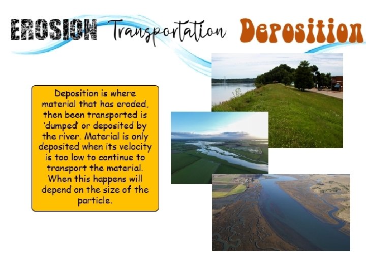
Interlocking Spurs How and why does deposition create


- Slides: 13
Interlocking Spurs
How and why does deposition create landforms along a river? All: Will be able to name 3 landforms found on the lower course of a river. Most: Will be able to explain how these landforms are formed through deposition. Some: Will be able to explain how these landforms are formed through deposition. Will begin to explore how these landforms have shaped the human environment. Geographical Vocabulary • • • Levee Flood Plain Estuary • • • Transportation Deposition Saltation • • • Traction Solution Suspension
Transportation is the process of eroded materials being moved down the river. Your Task 1: Watch the following video on the four types of transportation and answer the questions in your workbook. https: //timeforge ography. co. uk/vid eos_list/rivers/rive r-transportprocesses/ 1. What is eroded material named after it has been ‘broken off’? 2. How does transported material benefit our world? 3. How does the size of the material change how it is transported down the river? 4. Why is the river water murky? 5. How is dissolved material transported? 6. How is material like silt transported? What will the river look like if a lot of material is transported this way? 7. How is gravel transported? What happens to the gravel as it is transported? 8. What is needed for larger stones and boulders to be transported? 9. How is larger material transported? 10. What type of weather is needed for the largest sediment to be transported? Why?
Your Task: Name the transportation process. Link up the transportation process to the definition and diagram. Check your answers on page 48 of the revision guide once you have finished. A) Suspension 1) B) Traction 2) C) Saltation 3) D) Solution 4) Green) Small particles like silt and clay are carried along by the water. Blue) Large particles like boulders are pushed along the riverbed by the force of the water. Yellow) Materials are dissolved in the water and carried along. Orange) Pebble sized particles are bounced along the river bed by the force of the water.
Why does velocity and sediment size effect whether transportation or deposition is more dominant? Think Pair Share
Your Task 2: Watch the video then answer the following questions in your workbook. WORK SMART: Work in pairs to answer half of the questions then share your answers. https: //timeforge ography. co. uk/vi deos_list/rivers/f loodplains/ 1. What does a river look like in its middle/lower course? 2. Why does the river have a higher velocity and sediment load? 3. Why could a river burst its banks? 4. What does a flood plain look like? 5. How often do flood plains flood? 6. What is a characteristic of the material found on the banks and bed of the river? Why is it like this? 7. When will the transported material be deposited on the flood plain? 8. Why will vegetation on a flood plain cause deposition? 9. What type of sediment will be deposited closer to the river? Why? What depositional landform will this form? 10. Why are farms built on the flood plains but houses built on hills?
Your Task 3: Using page 51 of your revision guide answer the following questions in the PED paragraph structure. HINT: Plan your answer by writing bullet points on your whiteboard of the main bits of information you want to include and in what order. How does a levee form and change over time? (6 marks) How does an estuary form and change over time? (6 marks)
You can tell where the River Clyde turns tidal as the outline of the river outline turns black. What is the four figure grid reference for where the river outline turns black? 81 80 79 78 77 76 Jot down your ideas! 93 94 95 96 97 98
You can spot an embankment or Levee by a raised section of land shown by a double dotted line. Which six figure grid references show two Levees? A) 965784, 946792 80 79 78 77 B) 953775, 968772 76 Jot down your ideas! 93 94 95 96 97
Plenary: Write as many key terms from the topic so far on your whiteboard. River course Source Flood plain Valley Mouth Flood U-shaped valley Hard rock Downstream V-shaped valley Soft rock Embankment Channel Dissolves Levee Bed Transportation Estuary Bank Traction Tidal Vertical erosion Suspension Mudflat Lateral erosion Saltation Silt Upper course Solution Sand Middle course Velocity Clay Lower course Deposition Boulder Long profile Waterfall Cross profile Overhang Erosion Step Hydraulic action Plunge pool Attrition Gorge Abrasion Retreat Material Undercutting Sediment Interlocking spurs Load Challenge Yourself: With your partner test whether you can define each key term you have written down.
Question 1. • • BUGA the question. Box the command word. Under line the key words. Glance at the marks Annotate the question.