
Instituto Superior Politcnico Jos Antonio Echeverra TRAINING COURSE
- Slides: 32
Instituto Superior Politécnico José Antonio Echeverría TRAINING COURSE MCRR (Management Centers for Risk Reduction) EXPERIENCE OF THE CUBAN MODEL “Putting science in everyday language, here is something only few do” José Martí EXERCISE WORK OF MCRR IN PLANNING MEASURES FOR PREVENTION. Prof. Aux. Msc. Ing. Jorge Arcos Méndez Teléfono en GREDES 267 1123 Prof. Aux. Msc. Ing. Emilia Fors Garzón. E Mail: efors@arquitectura. cujae. edu. cu 1
OBJETIVES OF THE EXERCISE Modeling a situation of disaster by hurricane or heavy rain. Proposing preventive measures for disaster reduction in the MCRR in the territory, that promote climatic change adaptation and population sustainability. STARTING DATA • • Territory planning Information of the typology of buildings and its constructive conditions. Scale of estimated dangers to building by hurricane category. Data table of population and affected areas. Hurricane category table Flooding map Classification of natural hazards BIBLIOGRAPHY : Classification of flooding assumed by GREDES for different disaster studies. ARCOS COCA table for hazard classfication due to winds, different sources of Internet downloaded by Jorge Arcos about damages by flooding and winds in Puerto Rico. Typology of Cuban buildings. Description of Cuban urban typologies. 2
CONTENT OF THE EXERCISE Modeling the effects of winds of a II category Hurricane in Entre Ríos Community. Modeling the effects of flooding by heavy rains of up to 158 mm in 24 hours in a Residential Neighborhood OUTPUT DATA • Preventive measures for rehabilitation of the built fund. o Number of buildings proposed for imroving its constructive conditions. o Number of buildings proposed for changing its constructive typology. • Preventive measures in constructing protector works for reducing river flooding area • Preventive measures for urban planning. 3
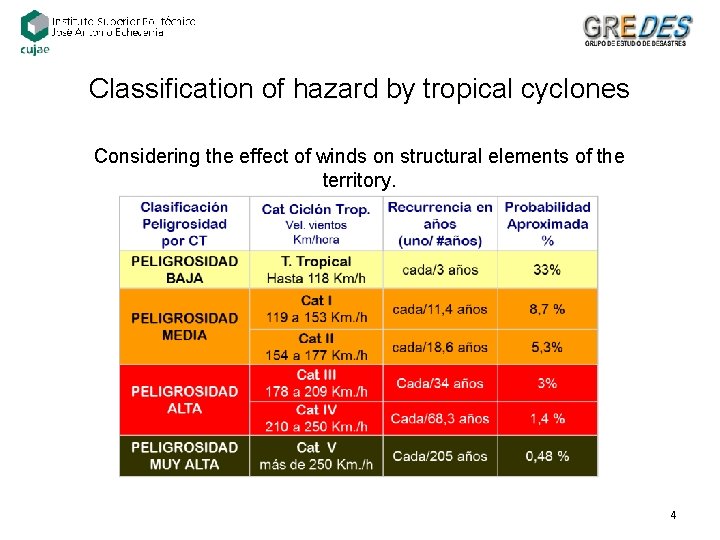
Classification of hazard by tropical cyclones Considering the effect of winds on structural elements of the territory. 4
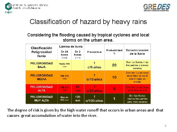
Classification of hazard by heavy rains Considering the flooding caused by tropical cyclones and local storms on the urban area. The degree of risk is given by the high water runoff that occurs in urban areas and that causes great accumulation of water into the river. 5
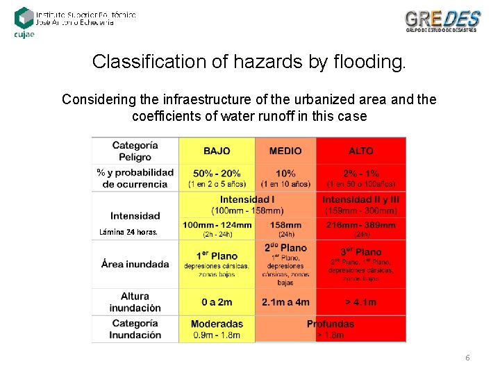
Classification of hazards by flooding. Considering the infraestructure of the urbanized area and the coefficients of water runoff in this case Lámina 24 horas. 6
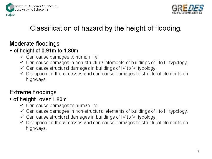
Classification of hazard by the height of flooding. Moderate floodings • of height of 0. 91 m to 1. 80 m ü ü Can cause damages to human life. Can cause damages in non-structural elements of buildings of I to III typology. Can cause structural damages in buildings of IV to VI typology. Disruption on the accesses and can cause damages to structural elements on highways. Extreme floodings • of height over 1. 80 m ü ü Can cause damages to human life. Can cause damages in non-structural elements of buildings of I to III typology. Can cause structural damages in buildings of IV to VI typology. Disruption on the accesses and can cause damages to structural elements on highways. 7
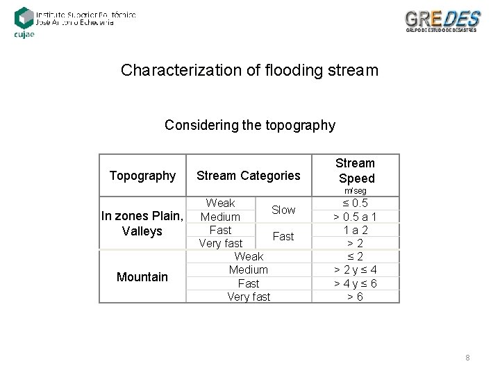
Characterization of flooding stream Considering the topography Topography Stream Categories Stream Speed m/seg In zones Plain, Valleys Mountain Weak Slow Medium Fast Very fast Weak Medium Fast Very fast ≤ 0. 5 > 0. 5 a 1 1 a 2 > 2 ≤ 2 > 2 y ≤ 4 > 4 y ≤ 6 > 6 8
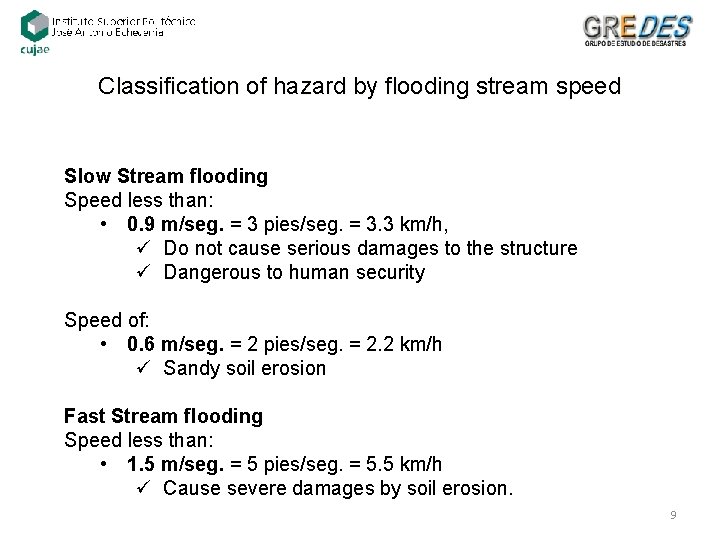
Classification of hazard by flooding stream speed Slow Stream flooding Speed less than: • 0. 9 m/seg. = 3 pies/seg. = 3. 3 km/h, ü Do not cause serious damages to the structure ü Dangerous to human security Speed of: • 0. 6 m/seg. = 2 pies/seg. = 2. 2 km/h ü Sandy soil erosion Fast Stream flooding Speed less than: • 1. 5 m/seg. = 5 pies/seg. = 5. 5 km/h ü Cause severe damages by soil erosion. 9
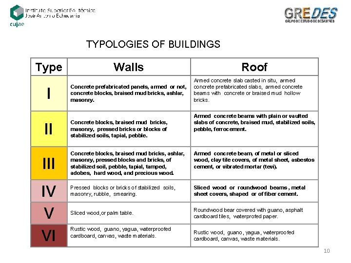
TYPOLOGIES OF BUILDINGS Type Walls I Concrete prefabricated panels, armed or not, concrete blocks, braised mud bricks, ashlar, masonry. II Concrete blocks, braised mud bricks, masonry, pressed bricks or blocks of stabilized soils, tapial, pebble. Roof Armed concrete slab casted in situ, armed concrete prefabricated slabs, armed concrete beams with concrete or braised mud hollow bricks. Armed concrete beams with plain or vaulted slabs of concrete, braised mud, stabilized soils, pebble, ferrocement. III IV V VI Concrete blocks, braised mud bricks, ashlar, masonry, pressed blocks and bricks, of stabilized soil, pebble, tapial, tamped, adobes, hard wood, and precious wood. Armed concrete beam, of metal or sliced wood, clay tile covers, of metal sheet, asbestos cement, or vibrated mortar (tevi). Pressed blocks or bricks of stabilized soils, masonry, rubble, smearing. Sliced wood or roundwood beams , metal sheet covers, shaped or of fiber cement. Sliced wood, or palm table. Roundwood bear covered with guano, asphalt cardboard tiles, waterprofed paper. Rustic wood, guano, yagua, waterproofed cardboard, canvas, waste materials. 10
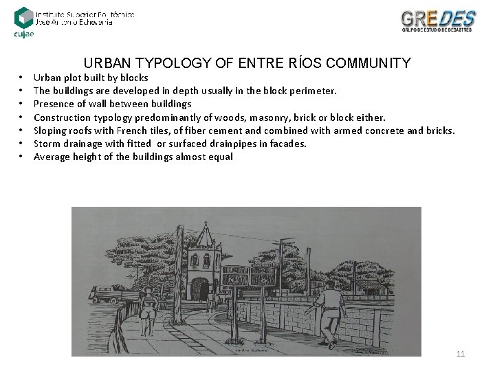
URBAN TYPOLOGY OF ENTRE RÍOS COMMUNITY • • Urban plot built by blocks The buildings are developed in depth usually in the block perimeter. Presence of wall between buildings Construction typology predominantly of woods, masonry, brick or block either. Sloping roofs with French tiles, of fiber cement and combined with armed concrete and bricks. Storm drainage with fitted or surfaced drainpipes in facades. Average height of the buildings almost equal 11
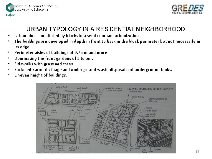
URBAN TYPOLOGY IN A RESIDENTIAL NEIGHBORHOOD • • Urban plot constituted by blocks in a semi compact urbanization The buildings are developed in depth in front to back in the block perimeter but not necessarly in its edge Perimeter aisles of buildings of 0. 75 m and more Dominating the front gardens of 3 to 5 m. Sidewalks with grass and trees Surfaced Storm drainage and underground waste disposal and underground tanks. Uneven height of buildings. 12
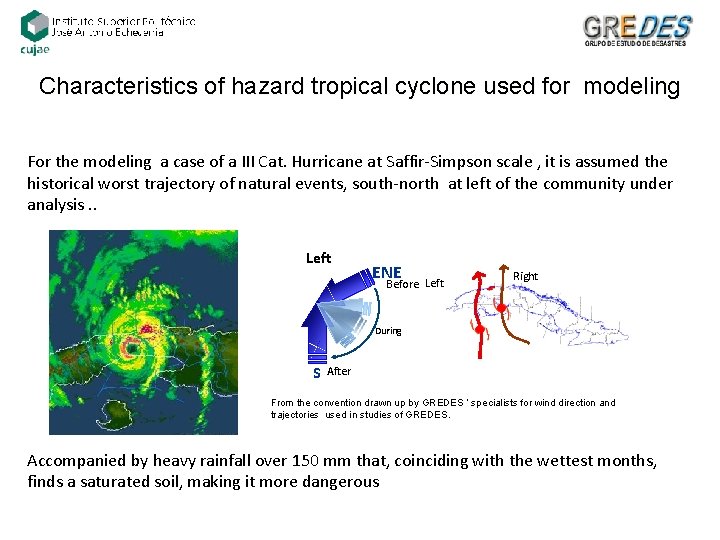
Characteristics of hazard tropical cyclone used for modeling For the modeling a case of a III Cat. Hurricane at Saffir-Simpson scale , it is assumed the historical worst trajectory of natural events, south-north at left of the community under analysis. . Left ENE Before Left Right During S After From the convention drawn up by GREDES ‘ specialists for wind direction and trajectories used in studies of GREDES. Accompanied by heavy rainfall over 150 mm that, coinciding with the wettest months, finds a saturated soil, making it more dangerous
Preventive measures to reduce vulnerability to the effects of heavy winds IMPORTANT NOTE: The effects caused by hurricane winds are regional, with dimensions over the territory choosen for the study. 14
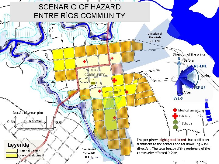
SCENARIO OF HAZARD ENTRE RÍOS COMMUNITY Direction of the winds NE - ENE Direction of the winds N Before NE-ENE ENTRE RÍOS COMMUNITY During After ESE-SE SSE-S Medical consulting Details of urban plot Policlinic P Schools SB Leyenda Historial Center New development Direction of the Winds SSE - S The periphery highlighted in red has a different treatment to the center zone for modeling wind direction, The total length of the periphery of the community affected is 2 km. 15
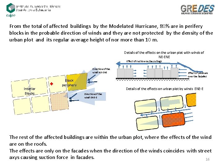
From the total of affected buildings by the Modelated Hurricane, 80% are in perifery blocks in the probable direction of winds and they are not protected by the density of the urban plot and its regular average height of nor more than 10 m. Details of the effects on the urban plot with winds of NE-ENE Effect of suction on the cellings Direction of the wind NE-ENE Interior Blocks Block periphery Effect of pressure over the facades Details of the effects on urban plot by winds ENE-E Direction of the wind ENE-E The rest of the affected buildings are within the urban plot, where the effects of the wind are on the roofs. The effects are only on the facades when the direction of the winds coincides with street axys causing suction force in facades. 16
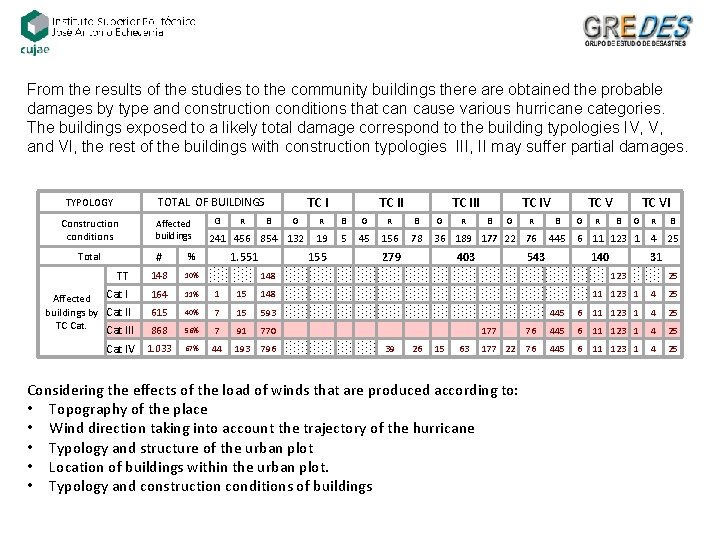
From the results of the studies to the community buildings there are obtained the probable damages by type and construction conditions that can cause various hurricane categories. The buildings exposed to a likely total damage correspond to the building typologies IV, V, and VI, the rest of the buildings with construction typologies III, II may suffer partial damages. TC I TOTAL OF BUILDINGS TYPOLOGY Construction conditions Total TT Affected Cat I buildings by Cat II TC Cat III Affected buildings G B G 241 456 854 132 # % 148 10% 164 11% 1 615 40% 868 Cat IV 1. 033 R 1. 551 TC III R B G 19 5 45 156 78 36 189 177 22 76 155 279 R TC IV B G 403 R TC V B G R TC VI B G R B 445 6 11 123 1 4 25 543 140 148 15 148 11 123 1 4 25 7 15 593 445 6 11 123 1 4 25 56% 7 91 770 177 76 445 6 11 123 1 4 25 67% 44 193 796 39 26 15 63 76 445 6 11 123 1 4 25 177 22 Considering the effects of the load of winds that are produced according to: • Topography of the place • Wind direction taking into account the trajectory of the hurricane • Typology and structure of the urban plot • Location of buildings within the urban plot. • Typology and construction conditions of buildings 31 123 25
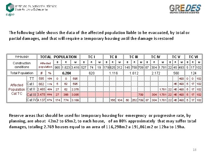
The following table shows the data of the affected population liable to be evacuated, by total or partial damages, and that will require a temporary housing until the damage is restored TYPOLOGY TOTAL POPULATION Construction conditions TC I B R M B Affected population 965 1. 823 3. 416 527 74 M B R TC III M B R TC IV M B R TC V M B % 595 10% 0 0 595 Affected Cat I 662 Population Cat II 2. 465 Cat TC Cat III 3. 478 11% 5 62 595 40% 27 62 2. 376 56% 27 366 3. 085 709 Cat IV 4. 137 67% 174 774 3. 189 TT R TC VI M B R M 19 179 625 312 145 758 709 87 304 1. 781 22 45 493 5 17 102 # Total Population 6. 204 R TC II 620 1. 116 1. 612 156 104 60 2. 172 252 709 87 560 124 493 0 0 102 45 493 5 17 102 1. 781 22 45 493 5 17 102 304 1. 781 22 45 493 5 17 102 Reserve areas that should be used for temporary housing for emergency or progressive rate, by planning, are about 42 m 2 to 69 m 2, to each house, of an 80% approximately that may suffer total damages, totaling 2. 769 houses equal to an area of 116, 298 m 2 a 191, 061 m 2 or 12 ha to 19 ha. 18
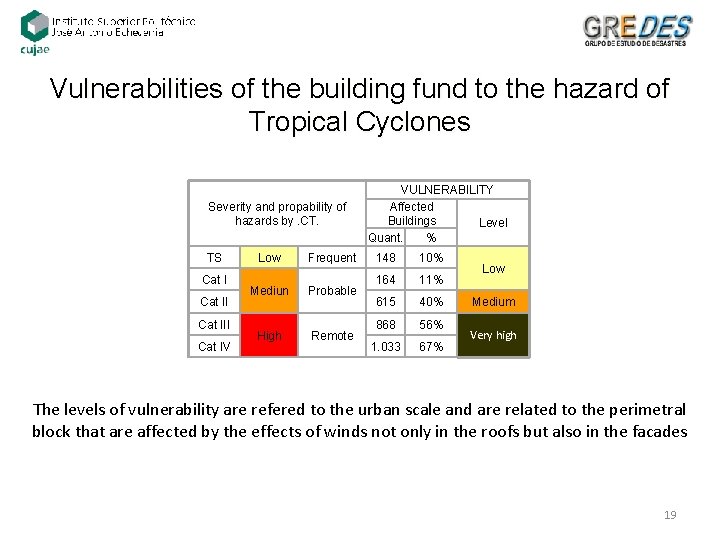
Vulnerabilities of the building fund to the hazard of Tropical Cyclones Severity and propability of hazards by. CT. TS Cat III Cat IV Low Frequent Mediun Probable High Remote VULNERABILITY Affected Buildings Level Quant. % 148 10% 164 11% 615 40% 868 56% 1. 033 67% Low Medium Very high The levels of vulnerability are refered to the urban scale and are related to the perimetral block that are affected by the effects of winds not only in the roofs but also in the facades 19
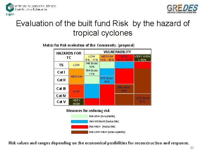
Evaluation of the built fund Risk by the hazard of tropical cyclones Matrix for Risk evaluation of the Community. (proposal) VULNERABILITY HAZARDS FOR TC TS Cat III LOW MEDIUM HIGH VERY HIGH 5% - 11% 12% - 40% 41% - 50% 148 Build. LOW 10% 164 Build. 11% MEDIUM 615 Build. 40% HIGH Cat IV Cat V 868 Build. 56% VERY HIGH 1, 033 Build. 67% Measures for reducing risk Risk LOW (Acceptable) Risk MEDIUM (Reducible) Risk HIGH (Reducible) Risk VERY HIGH (Unacceptable) Risk values and ranges depending on the economical posibilities for reconstruction and response. 20
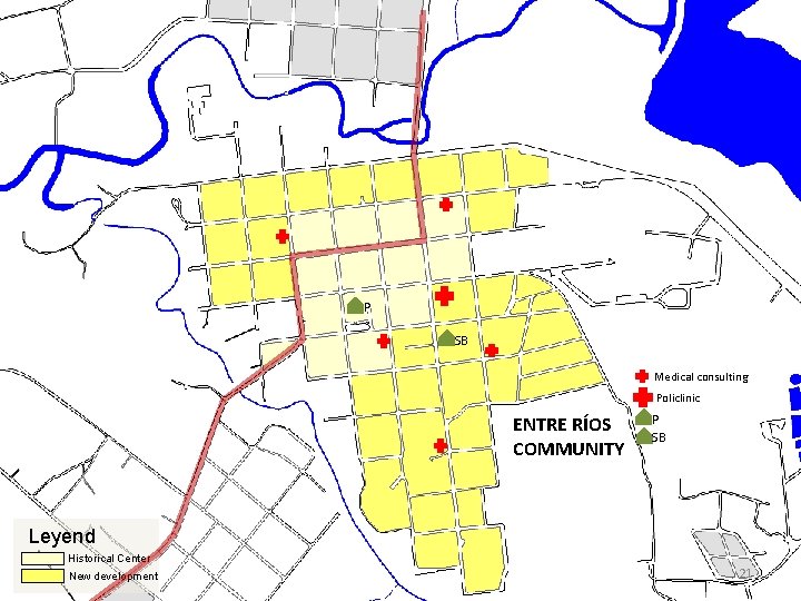
P SB Medical consulting Policlinic ENTRE RÍOS COMMUNITY P SB Leyend Historical Center New development 21
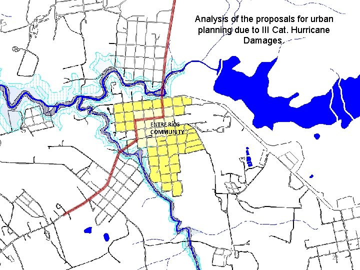
Analysis of the proposals for urban planning due to III Cat. Hurricane Damages. ENTRE RÍOS COMMUNITY 22
Preventive measures for reducing vulnerabilities to flooding by heavy rains IMPORTANT NOTE: RAINS, UNLIKE HURRICANES, HAVE SPECIFIC EFFECTS , therefore the analysis of vulnerability of flooding by heavy rains, (unlike the vulnerability by strong winds that can be done by general statistics of the conditions of the buildings in the territory) IS ONLY CIRCUNSCRIED TO THE BLOCKS WITHIN THE FLOODING MAPS AND TO THOSE THAT ARE LOCATED IN LOW AREAS, and not for the entire territory that covers a particular political division. 23
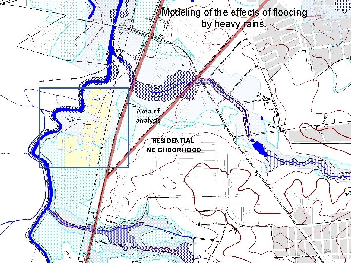
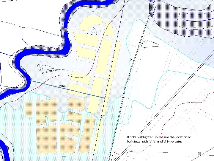
Modeling of the effects of flooding by heavy rains. Área of analysis RESIDENTIAL NEIGHBORHOOD 24
360 m Blocks highlighted in red are the location of buildings with IV, V, and VI typologies 25
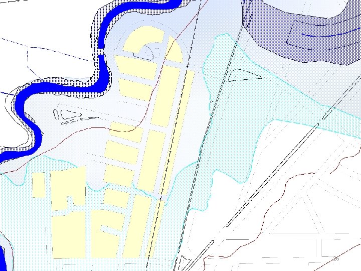
26
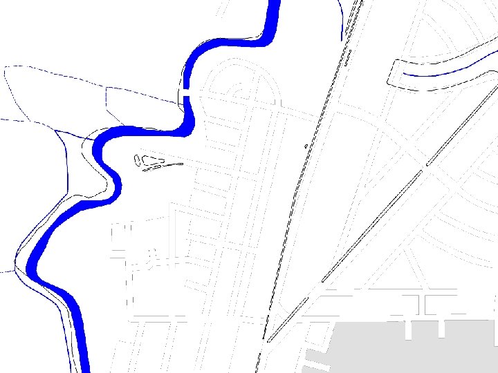
27
From the results of the studies to buildings by typology and construction conditions can be assumed the probable damages of buildings located in flooding levels 2 and 3. In the first level of flooding, there are only affected small areas of short-cycle crops. The buildings exposed to a likely total damage correspond to those of IV, V, and VI typologies, due to the construction materials used in roofs and walls not suitable to cases of flooding levels exceeding the strut. The rest of the buildings with I, II and III typologies may be considered to suffer damages in their non-structural elements and its functional vulnerability 28
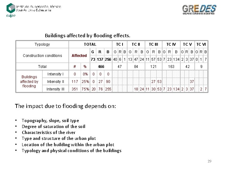
Buildings affected by flooding effects. Typology Construction conditions Total Buildings affected by flooding TOTAL Affected G TC I R B TC III TC IV G R B G R TC VI B GR B 73 137 256 40 6 1 13 47 24 11 57 53 7 23 134 2 3 37 0 1 7 # % 466 Intensity I 0 0% Intensity II 117 25% 0 Intensity III 351 0 0 47 84 121 163 42 9 0 27 90 27 53 37 75% 20 76 255 18 24 11 30 53 7 23 134 2 3 37 2 7 The impact due to flooding depends on: • • • Topography, slope, soil type Degree of saturation of the soil Characteristics of the river Type and structure of the urban plot Location of the building within the urban plot Typology and physical conditions of the buildings 29
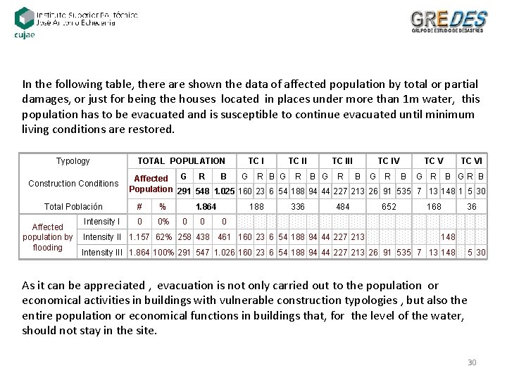
In the following table, there are shown the data of affected population by total or partial damages, or just for being the houses located in places under more than 1 m water, this population has to be evacuated and is susceptible to continue evacuated until minimum living conditions are restored. Typology Construction Conditions Total Población TOTAL POPULATION TC III TC IV TC VI B G R B G R B GR B Affected G R Population 291 548 1. 025 160 23 6 54 188 94 44 227 213 26 91 535 7 13 148 1 5 30 # % 1. 864 188 336 484 652 168 36 Intensity I 0 0% 0 0 0 Affected 148 population by Intensity II 1. 157 62% 258 438 461 160 23 6 54 188 94 44 227 213 flooding Intensity III 1. 864 100% 291 547 1. 026 160 23 6 54 188 94 44 227 213 26 91 535 7 13 148 5 30 As it can be appreciated , evacuation is not only carried out to the population or economical activities in buildings with vulnerable construction typologies , but also the entire population or economical functions in buildings that, for the level of the water, should not stay in the site. 30
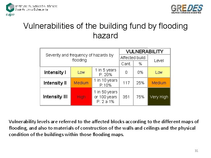
Vulnerabilities of the building fund by flooding hazard Severity and frequency of hazards by flooding Intensity I Low Intensity II Medium Intensity III High 1 in 5 years P: 20% 1 in 10 years P: 10% VULNERABILITY Affected build. Cant. % Level 0 0% Low 117 25% Medium 1 in 50 years or 100 years 351 P: 2 a 1% 75% Very High Vulnerability levels are referred to the affected blocks according to the different maps of flooding, and also to materials of construction of the walls and ceilings and the physical condition of the buildings within those flooding maps. 31
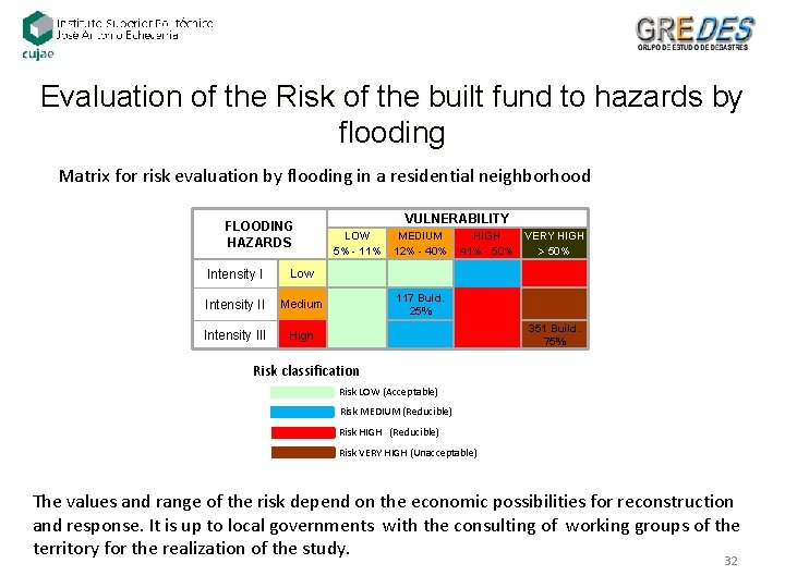
Evaluation of the Risk of the built fund to hazards by flooding Matrix for risk evaluation by flooding in a residential neighborhood FLOODING HAZARDS Intensity I Low Intensity II Medium Intensity III High VULNERABILITY LOW 5% - 11% MEDIUM 12% - 40% HIGH 41% - 50% 117 Buld. 25% VERY HIGH 50% 351 Build. 75% Risk classification Risk LOW (Acceptable) Risk MEDIUM (Reducible) Risk HIGH (Reducible) Risk VERY HIGH (Unacceptable) The values and range of the risk depend on the economic possibilities for reconstruction and response. It is up to local governments with the consulting of working groups of the territory for the realization of the study. 32