Information Technology and Coastal Zone Management An Introduction



- Slides: 84

Information Technology and Coastal Zone Management: An Introduction Coastal Services Center

CSC Activities and Feedback The approximately 500 coastal professionals trained in CSC sponsored information management classes identified these barriers to effective implementation at their workplace: • Cost • Not an agency priority • Technology failures in the past • Technology oversold in the past • Management does not understand the terminology or benefits • Management does not have a short or long term goal for information management • Management is constrained in systems procurement by other procurement policy • Management and technical staff do not communicate effectively

Coastal Information Management Curriculum • Information technology and coastal zone management • Introduction to GIS • Introduction to Metadata • Metadata Training • Training the Trainers - metadata • Introduction to Arc. View • Introduction to Avenue • Intermediate Arc. View • Introduction to Remote Sensing

Objectives • Demonstrate the benefits of information management technology • Increase the understanding of information management technology components • Discuss and demonstrate how GIS and related technologies improve the capability to analyze and synthesize information • Provide information on the current framework and future direction of spatial technologies • Encourage, facilitate, and support coastal information management capacity building within individual agencies • Facilitate the development of a Coastal National Spatial Data Infrastructure (CNSDI)

Topics for Today • Information management fundamentals • The 5 variables: – People – Data – Software – Hardware – Applications • Fundamental of spatial technologies • Example coastal applications • Federal, state, local, and university activities • Opportunities to leverage resources • Legislative initiatives • New technologies

Information Management is an Essential Activity: It’s what We Do

A Change in Technology Must Improve Effectiveness and/or Efficiency in Management or Operations

Information Technology from a Manager’s Perspective • Long-Term Goals • Short-Term Goals • Self-Preservation • Benefits Versus Costs

What Are Information Management Needs? • Word Processing • Spread Sheets • Database Management Systems • Graphics • Communications • Spatial Data Processing

Information Technology Trends Hardware Costs Software Costs Connectivity Ease of Use Data Availability 1980 1995 2110

Information Management System DATA HARDWARE PEOPLE SOFTWARE

People DATA HARDWARE PEOPLE SOFTWARE

Data DATA PEOPLE HARDWARE SOFTWARE

Software DATA SOFTWARE HARDWARE PEOPLE

Hardware HARDWARE DATA PEOPLE SOFTWARE

Synthesis DATA HARDWARE PEOPLE SOFTWARE

The Manager’s Role in Developing a GIS • System Development Process • Define Organizational Goals for Technology • Project Planning and Oversight • Personnel Selection • Performance Evaluation

Information Technology Must Be Relevant

Coastal Management Issues • Habitat Management • Non-Point Source Pollution • Hazard Mitigation: Long-Term, Short-Term • Beachfront Management • Resource Conservation • Inter-Governmental Cooperation

What are Spatial Data? • Spatial data include one or more elements that describe location. • Absolute location such as x, y coordinates like latitude and longitude • Or relative location such as “next, near, opposite, adjoining. ”

Visualization

Coordinates Link Everything

GIS Tracks Relationships by Location Spatial Database Layers e. g. Aids to Navigation “Spatial Join” e. g. Fish Habitats

A Consistent Index for All Relevant Data Graphics

Environmentally Sensitive Impact Areas Coastal GIS Shoreline Benthic Habitat Salinity Leases/Parcels Geodetic Control Sea Surface Temperatures Marinas Buoys Corals Bathymetry Geology Territorial Waters Legal Boundaries

Territorial GIS Land Use Geology Wetlands Land Cover Rivers and Lakes Political Boundaries Protected Areas Streets Soils Forest Cover Habitat Digital Elevation Models Geodetic Control

Land Sea Based GIS

GIS Related Technologies Remote Sensing GPS Mobile Communications Radar Softcopy Photogrammetry SONAR Internet Sonar Multibeam Aerial Photography

Global Positioning System GPS uses a series of 24 satellites and ground receivers to triangulate horizontal and vertical position.

Aerial Photography

Digital Orthohptoto Imagery

Satellite Remote Sensing

Airborne Remote Sensing

Using GIS and GPS to Implement South Carolina's Post-Hurricane Recovery Plan Doug Marcy

Interconnection through the Web GIS Database Internet Map Server NOS Map. Finder

Data Sources • Federal Government • State Government • Local Government • Private Industry • Your Own Operations Federal DATA Local

Federal Data Sources • United States Geological Survey (USGS) – Digital Orthophoto Quadrangles (DOQs) 1: 12, 000 and 1: 5, 000 – Digital Raster Graphics (DRGs) 1: 24, 000, 1: 100, 000, 1: 250, 000 – Digital Elevation Models (DEMs) 1: 24, 000 , 1: 100, 000, 1: 250, 000 – Digital Line Graphs (DLGs) 1: 24, 000 – NAPP 1: 40, 000 • Environmental Protection Agency (EPA) – Non-Point Source Data (BASINS) – EPA Regions Databases – Comprehensive Environmental Response, Compensation, and Liability Act (CERCLA) database – STORET

Federal Data Sources • National Oceanic and Atmospheric Administration (NOAA) – Bathymetry – Digital Shoreline – Nautical Charts – Benthic Habitat • Minerals Management Service – Outer Continental Shelf (OCS) Blocks – Active Lease Sites – Platform Locations • National Park Service (NPS) – National Park Boundaries – Vegetation, Streams, Roads, Trails for Selected Parks • United States Fish and Wildlife Service – National Wetlands Inventory (NWI) – Provide Extensive Training in GIS and GPS

State Government • Resource Management • Transportation • Emergency Management • Economic Development • NSGIC

State Data Sources • Statewide GIS Data Centers – Oregon State Service Center for Geographic Information Systems – Massachusetts Geographic Information System (Mass. GIS) • State Agency GIS Databases – South Carolina Department of Natural Resources – New Jersey Department of Environmental Protection • Libraries

Local Government • Land Ownership (cadastre) • Land Use • Infrastructure Management (water, sewer) • Transportation • Environmental Management

Your Organization Be sure to check with everyone in your own organization before you buy, contract for, or collect new data.

Private Industry • Utilities • Transportation • Facilities Management • Direct Marketing

Opportunities for Leveraging Resources to Overcome Obstacles to the Implementation of GIS

Federal Geographic Data Committee The Federal Geographic Data Committee (FGDC) is an interagency committee, organized in 1990 under OMB Circular A-16, that promotes the coordinated use, sharing and dissemination of geospatial data on a national basis.

FGDC Membership • The FGDC is composed of representatives from sixteen Cabinet level and independent federal agencies. • Steering Committee: – Bruce Babbitt, Secretary of the Interior, Chair of Steering Committee – Scott B. Gudes, Deputy Under Secretary for NOAA, Department of Commerce – National Association of Counties – National League of Cities – National States Geographic Information Council – Open. GIS Consortium – University Consortium for Geographic Information Science – International City/County Management Association


The Federal Geographic Data Committee coordinates the development of the National Spatial Data Infrastructure (NSDI). The NSDI encompasses policies, standards, and procedures for organizations to cooperatively produce and share geographic data.

The Vision of Coastal NSDI Current and accurate geospatial coastal and ocean data will be readily available to contribute locally, nationally, and globally to economic growth, environmental quality and stability, and social progress.

NSDI Strategy • Goal 1 – Increase the awareness and understanding of the vision, concepts, and benefits of the NSDI through outreach and education. • Goal 2 – Develop common solutions for discovery, access, and use of geospatial data in response to the needs of diverse communities. • Goal 3 – Use community based approaches to develop and maintain common collections of geospatial data for sound decision making. • Goal 4 – Build relationships among organizations to support the continuing development of the NSDI.

The NSDI is a Foundation of Common Interests and Needs • Clearinghouse - need to find access data • Metadata - need to know characteristics of data • Framework - need for common sets of data • Standards/Technology - need to transfer and integrate data • Partnerships - need to leverage resources

Standards • IHO - International Hydrographic Organization • FGDC - Federal Geographic Data Committee • ANSI - American National Standards Institute (ANSI)

Characteristics of a Successful NSDI • Shared responsibility • Focus on coordination and cooperation • Role of participants constantly changing • Primary emphasis on “place” • Dependent on partnerships • Building on common interests and needs

GIS In Federal Agencies USGS National Mapping Division • National Aerial Photography Program (NAPP) • Digital Orthophotograph Quarter Quadrangles (DOQQ) • 1: 24, 000 and 1: 100, 000 Digital Line Graph - all layers (DLG) • 1: 24, 000 Digital Raster Graphics (DRG) • State Coordinators Program • Advanced Systems Support Center (ASC) • Cost Share Programs

National States Geographic Information Council The purpose of NSGIC is to encourage effective and efficient government through the coordinated development of geographic information and technologies to ensure that information may be integrated at all levels of government. This is accomplished through education, research, and the development of policies, standards and guidelines. NSGIC fosters increased understanding and interest in the development, operation and maintenance of geographic information and geographic information systems.

NSGIC Strategy Plan February 1999 • Goals: – Assure that GIS programs and geospatial infrastructure of individual states are strong and diverse – Provide opportunities and mechanisms for states to partner with federal agencies – Foster opportunities and mechanisms for states to build the NSDI – Advance research in geographic information sciences and spatial data infrastructure

Local and Regional Government Activities • The National Association of Counties (NACo) • The National League of Cities • Western Governors Association • National Association of State Legislators • International City/County Management Association (ICMA) • Natural Resource Leadership Group (NRLG) • National Association of Regional Councils (NARC)

Other Organizations • University Consortium for Geographic Information Science • Open. GIS • Urban Regional Information Systems Association • American Association of Geographers • American Geophysical Union • Geospatial Information and Technology Association • American Congress on Surveying and Mapping • American Society of Photogrammetry and Remote Sensing

Funding Sources • FGDC – Cooperative Agreement Programs – Framework Demonstration Projects – NSDI Benefits Program • NOAA – High Performance Computing and Communications Program (HPCC) – Environmental Systems Data and Information (ESDIM) – Coastal Services Center • Broad Area Announcements – NOAA Environmental Data Rescue Program – CZ State Grants • EPA, NASA, NSF - other funding source

Legislation and Budget Initiatives • Coastal Zone Management Act Section 310 Reauthorization – Desirable to add language to this section that would enhance state efforts for the development of the Coastal and Ocean NSDI – Community Federal Information Partnership

Community Federal Information Partnership Objectives • Stimulate local and regional entities to engage in community based data collection, sharing, and use • Increase the capability of the geospatial community to implement the goals and objectives of the NSDI • Provide every local government jurisdiction technical infrastructure and training to meet their basic needs to use geospatial data to make informed place based decisions • Ensure federal agencies capabilities to meet their full responsibilities for full NSDI implementation by 2004

Community Federal Information Partnership Components • Advance the capacity of the Nation’s communities to create and use geospatial data for sound decision making – Decision support tools – Data collection activities – Collection of high priority data sets – Collection of NSDI-compliant metadata – Support of research and development

The Manager’s Role in Developing a GIS • System Development Process • Define Organizational Goals for Technology • Personnel Selection • Project Planning and Oversight • Performance Evaluation • Communicating Results • Analyzing Future Trends and Preparing the Organization

Know the Quality of Your Data • Accuracy • Scale • Timeliness 1: 20, 000 Shoreline • History GISGO Garbage in • Spatial Garbage Out 1: 70, 000 Shoreline

Identification_Information: Citation_Information: Originator: NOAA Coastal Services Center Publication_Date: 19980930 Title: Spatial Extent of the Clean Water Act in the Southeast U. S. - 1998 Geospatial_Data_Presentation_Form: Map Publication_Information: Publication_Place: Charleston, SC Publisher: NOAA Coastal Services Center Online_Linkage: http: //www. csc. noaa. gov/ Larger_Work_Citation: Citation_Information: Originator: NOAA Coastal Services Center Publication_Date: 19980930 Title: Ocean Planning and Governance Geographic Information System (Ocean GIS) Publication_Information: Publication_Place: Charleston, SC Publisher: NOAA Coastal Services Center Other_Citation_Details: none Description: Abstract: The Ocean Planning and Governance Geographic Information System (Ocean GIS) is a prototype online regional marine GIS covering the vast ocean area bounded by the Carolinas, Georgia, Florida, the exclusive economic zone, and various maritime boundaries. The Ocean GIS was developed to provide for state and local level policy frameworks. Purpose: The Ocean GIS provides marine resource managers with timely and equitable access to downloadable data, cutting-edge online mapping functionality, and guidance on how to use GIS in a meaningful way with respect to ocean management. THE DATA INCLUDED IN THIS APPLICATION ARE BASED ON INTERPRETATION OF AVAILABLE INFORMATION AND SHOULD NOT BE CONSTRUED AS LEGALLY BINDING. Time_Period_of_Content: Time_Period_Information: Range_of_Dates/Times: Beginning_Date: 1995 Ending_Date: 1998 Currentness_Reference: Publication date Status: Progress: Complete Maintenance_and_Update_Frequency: unknown Spatial_Domain: Bounding_Coordinates: West_Bounding_Coordinate: -87. 6349 East_Bounding_Coordinate: -71. 3727 North_Bounding_Coordinate: 36. 5556 Metadata • “Data about data” or “information about data” • Description of the content, quality, condition, and other characteristics of data • Standardized representation of information, or a common set of terms for data • National Spatial Data Infrastructure

Applications APPLICATIONS DATA HARDWARE GIS SOFTWARE PEOPLE

Coastal Management and Technology

Quality Information Management is about Preparing for the Future by Working Smarter Today • Increasing need to: – share data – analyze and synthesize data – visualize information

Information Technology from a Manager’s Perspective • Long-Term Goals • Short-Term Goals • Self-Preservation • Benefits Versus Costs

Conceptual Design • Scope • Scale • Functionality Scope Scale

Detailed Design • Develops blueprints for the system based on the architectural drawings of the conceptual design.

Implementation • Project management skills are the key to successful implementation. – Planning – Scheduling – Budgeting – Problem Solving – Evaluation and Adjustment

Project Management • Every project needs a manager • Plans need to be researched and documented • Monitoring of progress should be consistent and frequent • Problems are inevitable; the crux is how well the organization deals with them • Information Management - sharing and synthesis is very political at times

Resource Allocation • Dollars • People • Manager’s Time

Project Evaluation • Evaluation should be part of the plan • Clear measures for success must be established • Performance data must be collected as part of the process • Evaluation should result in positive actions to improve

Summary: GIS in Context • Federal Government • State Government • Local Government • Private Industry

GIS and Information Management • Location links all information – Data sharing – Data quality – Data processing • Graphics let you visualize information – More efficient data collection and analysis – More effective analysis and presentation

Appendix

Ocean Planning and Governance GIS Project Creating an integrated geographic information system (GIS) that georeferences the statutory and legal framework for regional ocean resource governance and management. North Carolina South Carolina Georgia Florida

Priority Issues in the Southeast – Critical Habitat Protection – Conflict Areas/Economic Valuation – Beach Renourishment – Sustainable Fisheries – Mitigation and Hazards * Underlying Issue - Education

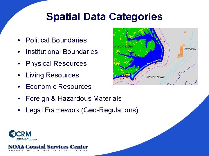
Spatial Data Categories • Political Boundaries • Institutional Boundaries • Physical Resources • Living Resources • Economic Resources • Foreign & Hazardous Materials • Legal Framework (Geo-Regulations)

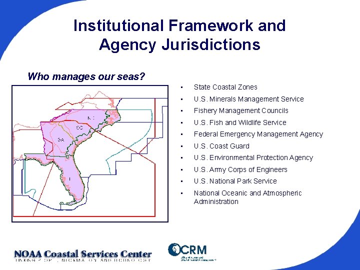
Institutional Framework and Agency Jurisdictions Who manages our seas? • State Coastal Zones • U. S. Minerals Management Service • Fishery Management Councils • U. S. Fish and Wildlife Service • Federal Emergency Management Agency • U. S. Coast Guard • U. S. Environmental Protection Agency • U. S. Army Corps of Engineers • U. S. National Park Service • National Oceanic and Atmospheric Administration

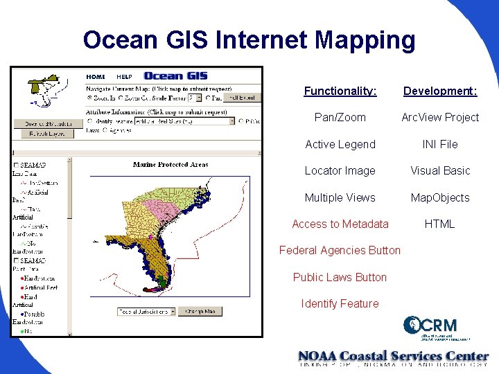
Ocean GIS Internet Mapping Functionality: Development: Pan/Zoom Arc. View Project Active Legend INI File Locator Image Visual Basic Multiple Views Map. Objects Access to Metadata HTML Federal Agencies Button Public Laws Button Identify Feature

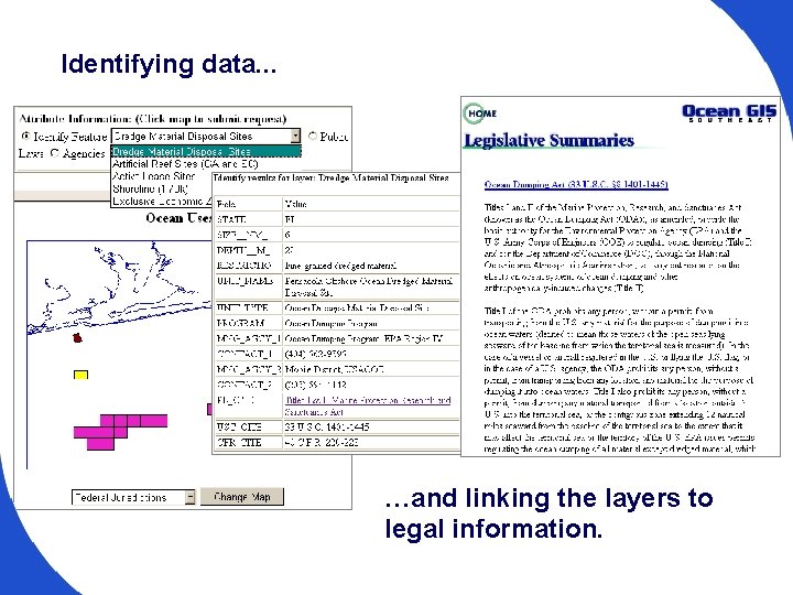
Identifying data. . . …and linking the layers to legal information.