Indus River Valley Civilization Indian Subcontinent Humans moved

Indus River Valley Civilization

Indian Subcontinent • Humans moved to India before 2, 000 B. C. • Set up villages in the Indus River Valley • India’s situation is a little different because it’s a Subcontinent—landmass including India, Pakistan, and Bangladesh – that almost separates from the rest of Asia • The Himalayas and Hindu Kush Mountains separate India from much of the rest of Asia

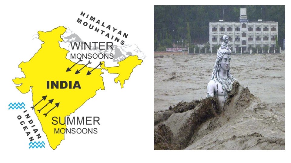
Geography of the Indian Subcontinent • Mountains to north, desert to east (Isolates Indus people from much of the world) • Mo unt Indo-Gangetic Plain – Fertile plain ains created from Indus & Ganges Rivers • Southern India, a dry plateau flanked by mountains with few rivers • Narrow strip of tropical land along coast • Farming is only possible along the Indus River, like with the other Mesopotamia and Egypt Desert
 • Early Indians rely on two things to grow their crops")
Geography (Cont. ) • Early Indians rely on two things to grow their crops – The Indus River and Monsoons • Monsoons – Seasonal winds that bring rain to India • Occur between July and September • They are necessary to much of India’s crops – without the rain the crops could die and cause famine • Rainfall is unpredictable – droughts or floods Could cause • Depending on which way the Monsoon winds blow, they could end up pushing the rain away from most of India out back into the ocean

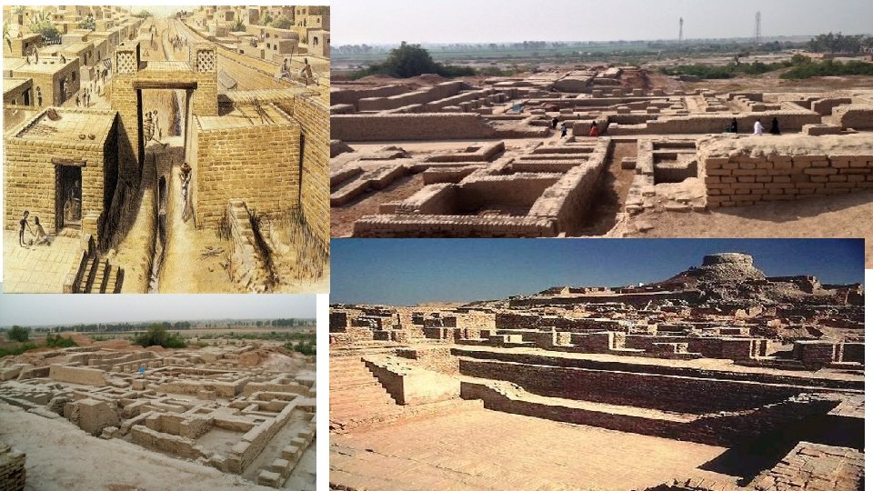
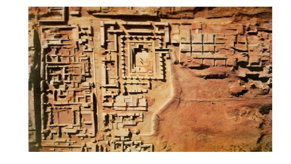
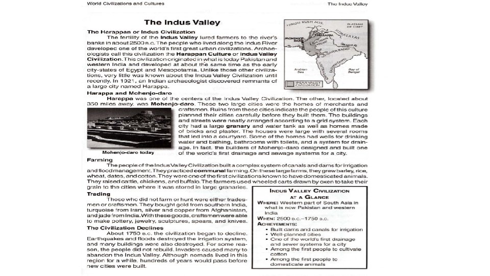
Arrivals and Cities • 2500 B. C. – While the Egyptians were building their pyramids, the Indus villages grow into cities • Built in a square grid system – Think graphing paper!! (Also, streets were 30 feet apart) • Suggests that there were strong central governments that spent a lot of time planning their cities • A lot more well thought out than the Mesopotamian cities were • Indus Engineers make sewage systems • As good as any sewage system until the 1800 s • Sewage system allows Indus people to get rid of waste so it doesn’t pile up • Not removing waste means that germs and diseases spread • The largest cities were Kalibangan, Mohenjo Daro and Harappa • Called Harappan Civilization after on major Indus city called Harappa

Culture • Writing system has 400 symbols – can’t be understood • Cities are uniform in culture • All are built on square grids, have plumbing, etc. • All have a central location - citadel • Few social divisions – men and women could have high status (priests – probably led the city or helped lead it) • Few weapons of war have been located – suggest limited conflict • Found clay children’s toys • Possibly polytheistic – pictures of gods or spirits on pottery and tablets • No actual temples have been found as of yet • May have been a major fertility goddess that was worshipped

Trade • Traded pots, beads, shells, gold with other societies • Gold and silver came from Afghanistan • Precious stones came from ancient Persia (Mesopotamia) and the Deccan Plateau (inner India) • Other metals like copper were also traded along the Caspian Sea and Persian Gulf • Indus seals were found in Sumer (Mesopotamia) – probably identifying Indus goods • Eventually the Indus cities were abandoned due to several factors • Famine • Decrease in quality of city building • Invasions from foreign groups (Aryans)

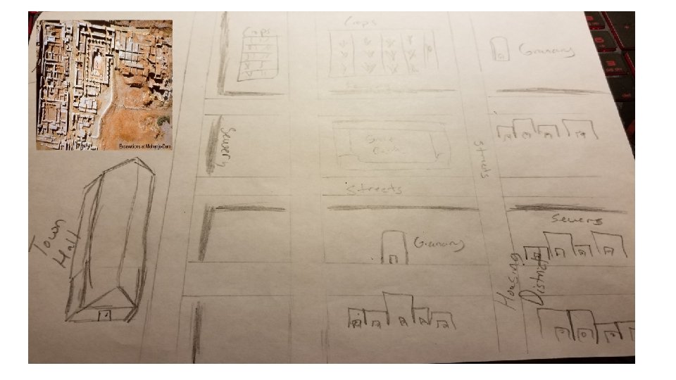
Harappa City Planning Activity • Students will draw a quick sketch of a city found in Harappa • Drawn in a grid/square slot style • Students will draw and sketch the city – city must include the following items: • Granaries • Great Bath • Town Hall • Housing District • Streets • Drainage System – drawing sewer pipes or lines • Crops • Lastly, give the city a name and turn it in

Granary Houses Great Bath Streets Town Hall Drainage System/Sewer

ASSIGNMENT Name: Date Period: Ancient India, 2500 – 1500 B. C. pg. 45 Note: 1. ) Draw in the rivers using pg. 45; then label them 2. ) Use compass rose and pgs. 44 – 45 to answer questions on the back! 1. 2. 3. 4. 5. 6. 7. 8. 9. 10. 11. 12. 13. 14. 15. 16. 17. 18. 19. 20. 21. 22. Term List India Himalayas Hindu Kush Mountains Himalaya Mountains Karakorum Mountains Khyber Pass Bolan Pass Indo-Gangetic Plain Thar Desert Deccan Plateau Western Ghats Eastern Ghats Arabian Sea Bay of Bengal Indus River Ganges River Brahmaputra River Godavari River Krishna River Harappa Kalibangan Mohenjo-Daro *Draw peaks for Mountains, use two colors for the map*

Compass Rose Questions!! 1. What direction is the Brahmaputra River from Harappa? 2. What direction is Mohenjo Daro from the Thar Desert? 3. What direction are the Himalayas from the Declan Plateau? 4. What direction is the Bay of Bengal from the Arabian Sea? 5. What direction is the Eastern Ghats from the Himalayas? 6. 7. What direction is the Indo-Gangetic Plain from the Arabian Sea? What direction is the Bolan Pass from Kalibangan? Questions from pgs. 44 - 45 1. What countries are part of the Indian Subcontinent? 2. What are the two rivers that flow through the Indus Valley? 3. What lies below the Indo-Gangetic Plain? 4. How do the Ghats mountains affect the Deccan Plateau? 5. What are monsoons? What do they do? 6. What are some environmental challenges that the Indus Civilization faced?
- Slides: 16