Improving WSDOT Response to Rapidly Changing Weather Conditions


 in Washington State.")


- Slides: 26
Improving WSDOT Response to Rapidly Changing Weather Conditions Cliff Mass and Rick Steed Department of Atmospheric Sciences University of Washington
There is a class of weather problems that cause major delays and large numbers of accidents on Washington State roadways: Sudden weather changes bringing heavy snow, heavy rain, and rapid losses of visibility
An Example: April 1 Convergence Zone Snow Hits Snoqualmie Pass
Dozens of Accidents, A Pregnant Woman is Killed, and the Pass is Closed for Hours to Clear the Cars
We could see it coming…. • High-resolution forecasts showed the future threat • Weather radar clearly showed the threat developing
We have built much of the technology for short-term snow prediction using realtime observations and modeling
This is a failure mode that occurs frequently in the passes • Sudden heavy snow from a front or convergence zone or some other feature. • Unprepared motorists, often going too fast and without proper equipment (chains, decent tires, 4 -wheel drive) start having multiple accidents. • The accidents close the road and make it difficult to remove the snow and deal with slippery conditions • Have to close the pass for hours to clean the mess.
Imagine a different approach • WSDOT provided real-time, short-term forecasts of such rapidly deteriorating conditions. • Using reader boards and flow control, greatly slow down the traffic on these roads, provide warnings of severe conditions, and reduce access to the highways until the threat is past. Twitter messages. State Patrol.
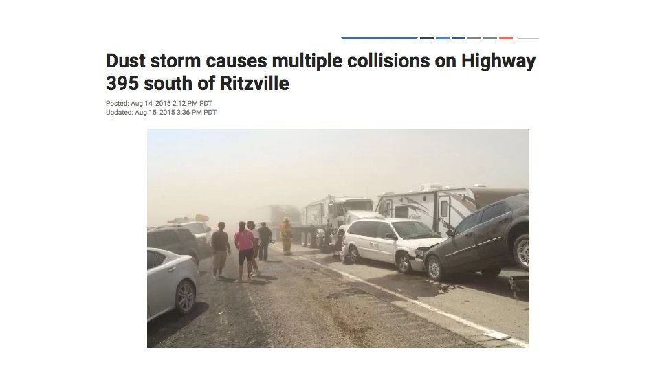
Another Example: Dust Storms in Eastern Washington • Winds, picking up rapidly from a thunderstorm outflow or cold front, causes rapid decline of visibility that can caused multiple accidents, sometimes involving 10 -30 cars. • Can close down major roads, such as I-90.
August 12, 2014 • The accidents include a three car, two semi truck crash on I-90 about 21 miles west of Ritzville, a two semi truck crash on State Route 26 in the town of Dusty and a two car crash on Highway 395 about 26 miles south of Ritzville. • Eastbound I-90 is down to one lane west of Ritzville for the multiple car and semi-truck accident.
Forecasting Dust Events • Can predict the strong winds using high-resolution models • Can observe the winds from surface locations • Can view the dust from space.
Reducing the carnage • With real-time forecasts of the winds and the ability to observe the dust, could WSDOT intervene? • Message boards? Highway radio broadcasts? State Patrol intervention? Warning capability of WSDOT app? Twitter warnings.
Heavy wildfire smoke can do the same….
Heavy Rain Over Roadways • Heavy rain over roads can cause chain reaction accidents involving many vehicles. • First, car slows as loses visibility entering rain, or being blinded leaving rain by the sun • Following cars are too close and hit the first car, followed by more cars behind.
Within two weeks there were TWO multi-car accident incidents: one with 56 cars and another with 55 cars.
Radar one hour before The first occurred on February 6, 2004 at 2: 56 PM (2256 UTC)
Often associated with heavy convective rain that can be seen and tracked using weather radar • Can give skillful forecasts up to an hour ahead of time. • Could use reader boards to slow down traffic that will cross the path of the heavy rain.
The Proposal • Make use of the considerable software and weather data infrastructure already in place. • Build real-time applications that will provide guidance to WSDOT personnel and others to control traffic and warn motorists. • Give WSDOT the tools to PREVENT problems from sudden severe weather, rather than cleaning up the mess afterwards.
Second Proposed Project: Mapping Road Surface Temperatures from WSDOT Trucks
Roadway Ice is the Number One Weather Killer (and Injurer) in Washington State.
There are only a limited number of RWIS and other sites providing real-time roadway temperatures
More information is crucial for proper snow/ice maintenance of the roadways and warning • WSDOT needs much more comprehensive information on roadway temperatures around the State. • Large value to maintenance (where to pretreat, where need trucks) • Such information could also be used to warn motorists in real-time. • Could provide a much more comprehensive view using roadway temperature sensors on trucks, combined with other observations assets (e. g. , RWIS, Seattle road sensors) and high-resolution weather model predictions. • Truck sensors use the infrared radiation emitted by the roads to determine temperature.
About 500 WSDOT trucks now have pavement temperature sensors and communication capabilities
Approach • Collect and QC all truck temperatures in real time • Combine with RWIS (and other sensors) to create real-time maps of road temperatures based on observations only. • Use this information to correct model-based surface temperatures to provide an even more comprehensive description of road surface temperatures around Washington State.
The End