Improving Precipitation and Streamflow Forecasts for Amite River

- Slides: 1

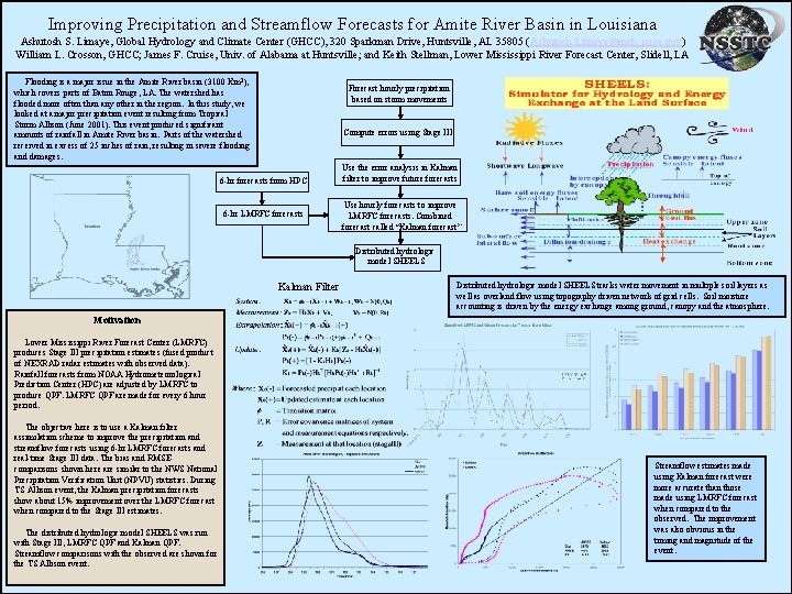
Improving Precipitation and Streamflow Forecasts for Amite River Basin in Louisiana Ashutosh S. Limaye, Global Hydrology and Climate Center (GHCC), 320 Sparkman Drive, Huntsville, AL 35805 (Ashutosh. Limaye@msfc. nasa. gov) William L. Crosson, GHCC; James F. Cruise, Univ. of Alabama at Huntsville; and Keith Stellman, Lower Mississippi River Forecast Center, Slidell, LA Flooding is a major issue in the Amite River basin (3100 Km 2), which covers parts of Baton Rouge, LA. The watershed has flooded more often than any other in the region. In this study, we looked at a major precipitation event resulting from Tropical Storm Allison (June 2001). This event produced significant amounts of rainfall in Amite River basin. Parts of the watershed received in excess of 25 inches of rain, resulting in severe flooding and damages. Forecast hourly precipitation based on storm movements Compute errors using Stage III 6 -hr forecasts from HPC 6 -hr LMRFC forecasts Use the error analysis in Kalman filter to improve future forecasts Use hourly forecasts to improve LMRFC forecasts. Combined forecast called “Kalman forecast” Distributed hydrologic model SHEELS Kalman Filter Distributed hydrologic model SHEELS tracks water movement in multiple soil layers as well as overland flow using topography driven network of grid cells. Soil moisture accounting is driven by the energy exchange among ground, canopy and the atmosphere. Motivation Lower Mississippi River Forecast Center (LMRFC) produces Stage III precipitation estimates (fused product of NEXRAD radar estimates with observed data). Rainfall forecasts from NOAA Hydrometeorological Prediction Center (HPC) are adjusted by LMRFC to produce QPF. LMRFC QPF are made for every 6 hour period. The objective here is to use a Kalman filter assimilation scheme to improve the precipitation and streamflow forecasts using 6 -hr LMRFC forecasts and real-time Stage III data. The bias and RMSE comparisons shown here are similar to the NWS National Precipitation Verification Unit (NPVU) statistics. During TS Allison event, the Kalman precipitation forecasts show about 15% improvement over the LMRFC forecast when compared to the Stage III estimates. The distributed hydrologic model SHEELS was run with Stage III, LMRFC QPF and Kalman QPF. Streamflow comparisons with the observed are shown for the TS Allison event. Streamflow estimates made using Kalman forecast were more accurate than those made using LMRFC forecast when compared to the observed. The improvement was also obvious in the timing and magnitude of the event.