Impact of horizontal resolution 112 to 150 on
 on Gulf Stream separation and penetration Eric")


 and")
 CNES-CLS 2013 1/12° 1/50° 1/25°")
 CNES-CLS 2009 1/12° 1/50° 1/25°")
 AVISO 1/12° 1/50° 1/25°")
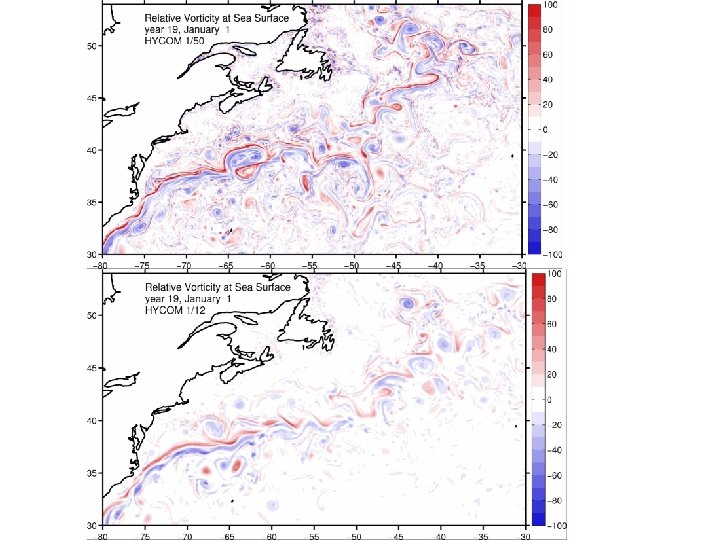
 Years 16 -20")
 Years 16 -20")
 AVISO 1/12° 1/50° 1/25°")
?")
 TOTAL GEOSTROPHIC")


- Slides: 22
Impact of horizontal resolution (1/12° to 1/50°) on Gulf Stream separation and penetration Eric Chassignet and Xiaobiao Xu Florida State University
Questions • When do we have convergence? • How well do the simulations compare to observations? • When is the solution “good enough”? • Are the mesoscale and sub-mesoscale eddy activity representative of quasigeostrophic (QG) or surface quasigeostrophic (SQG) turbulence?
Approach • Identical North Atlantic configurations with the horizontal resolution varying from 1/12° to 1/50° Analysis • • Comparison to observations Ratio of ageostrophy to geostrophy Ability of altimetry to represent eddy activity Power spectra
• Identical 32 layers HYCOM configuration including topography. • Climatological forcing with daily variability • Viscosity as a function of grid spacing (1/12° and 1/25°) • Same viscosity for 1/25° and 1/50° 500 k CPU-hours per model year for the 1/50°
MKE Atlantic simulation spinup Domain averaged kinetic energy of monthly mean flow (thin) and 12 -month averages (thick)
Mean SSH (Years 16 -20) CNES-CLS 2013 1/12° 1/50° 1/25°
Mean SSH (Years 16 -20) CNES-CLS 2009 1/12° 1/50° 1/25°
SSH variability (Years 16 -20) AVISO 1/12° 1/50° 1/25°
Mean zonal velocity at 55°W (Richardson, 1985) Years 16 -20
Mean Eddy Kinetic Energy at 55°W (Richardson, 1985) Years 16 -20
Surface EKE (Years 16 -20) AVISO 1/12° 1/50° 1/25°
Why is the modeled EKE in the Gulf Stream is higher than altimetry (AVISO)? • Ageostrophic contribution? • Spatial and temporal averaging in the observations? • Smaller viscosity in model than in reality?
EKE geostrophic difference (1/50°) TOTAL GEOSTROPHIC
For a typical month
Zoom Warm ring Cold ring Ekman drift
SSH spectra in the North Atlantic 1000 250 70 km km km 10 km 1/12° 1/25° 1/50° Winter Summer k-5 -5. 124 (-5. 223, -5. 025) -4. 905 (-4. 983, -4. 828) -4. 962 (-5. 038, -4. 886) Linear fit coefficients (with 95% confidence bounds) for horizontal scale of 70 -250 km
SSH wavenumber Spectrum The results, which are independent of resolution, suggest that the SSH spectra slope is k-5, in agreement with QG turbulence theory. This is in agreement with shipboard ADCP observations (Wang et al. , 2010) and the latest spectra calculated from along-track satellite altimetry data with high-frequency noise corrections (Zhou et al. , 2015). Seasonal dependence is most significant below 70 km. SSH spectral slope is k-4 in quiescent regions.
Altimetry resolves eddy scales greater than 150 km k-5
Impact of averaging on EKE AVISO 1/50° 150 km band pass + 10 -day 1° average 150 km band pass
Summary • Significant improvement in Gulf Stream model representation at 1/50°. • Time and spatial averaging are responsible for the observed difference between altimetry and model EKE. • The ageostrophic component in eddies is always cyclonic and increases/decreases the EKE on the north/south side of the Gulf Stream. • Power spectra agree with QG turbulence.
Questions?