IEM Dog and Pony Show Daryl Herzmann akrherz


, not altruistic hyperbole.")


")


 Percentage of")


 WEATHER BUREAU ACADEMIA Average Size (sq")


- Slides: 64
IEM Dog and Pony Show Daryl Herzmann @akrherz Iowa State University
Who am I and why am I here? • 2001 Meteor BS degree • Work for Iowa State University • Contractor with NWS • Co-Creator of NWSChat • I like free food (note: remove this before talk if no free food is present) Photo: AP Images
See something you don’t like? Yell at me! Photo: AP Images
Diplomatic Immunity June 2012 NOAA Team Member of the Month 2007 NOAA Environmental Hero
What’s a Dog and Pony Show? Wikipedia - "Dog and pony show" is a colloquial term which has come to mean a highly promoted, often over-staged performance, presentation, or event designed to sway or convince opinion for political, or less often, commercial ends. Photo: Blogspot. com
What shall we discuss? • Converting Watches into Warnings • My standard ranting about storm based warnings • IEM archives and web tools that may help you out – IEM Cow – IEM Raccoon
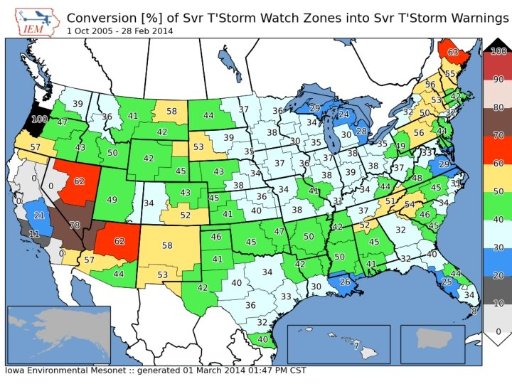
Purpose of my maps is not to show good/bad offices, but show local gradients
Chapter 1 WATCHES & WARNINGS
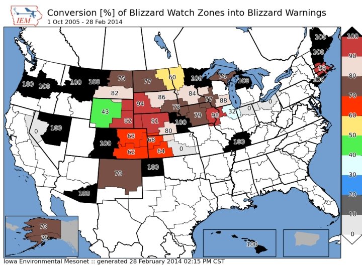
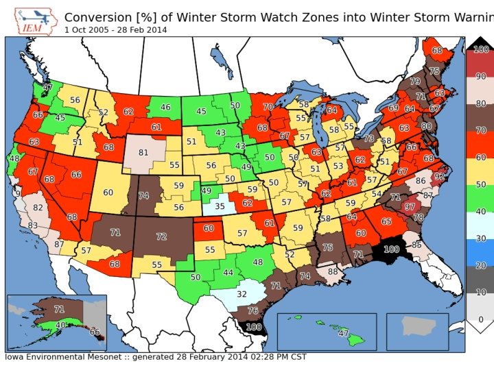
1 Oct 2005 – 28 Feb 2014 NWS Conversion of Watches into Warnings (double accounting means totals can be over 100%) 3, 669 UGC No WWA Blizzard Watches 5. 8% Blizzard Warning Wind Chill Warning 75. 6% 11. 6% Winter Storm Warning 11. 1% 73, 428 UGC Winter Storm Watches Winter Storm Warning 60. 6% Winter Weather Advsiory 34. 4% Blizzard Warning 6. 1% (4, 459!!) Wind Chill Advisory 7. 5% No WWA 4. 6% Snow Advisory 5. 3%
1 Oct 2005 – 28 Feb 2014 NWS Watches before a Warning (double accounting means totals can be over 100%) Winter Storm Watch 51. 2% 8, 702 UGC No Watch Blizzard Warnings 26. 0% Blizzard Watch High Wind Watch Wind Chill Watch 31. 3% 2. 7% 0. 7% 64, 980 UGC Winter Storm Warnings Winter Storm Watch 70. 6% Areal Flood Watch 1. 2% High Wind Watch 0. 8% No Watch 28. 1% Blizzard Watch 0. 7%
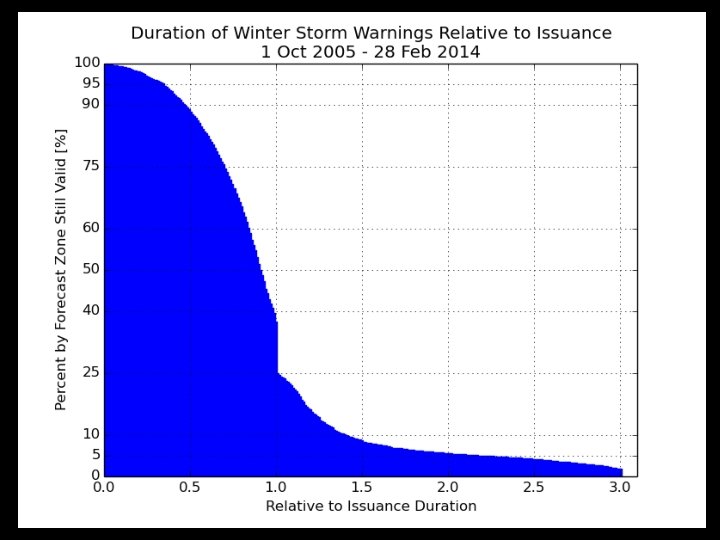
10% of Blizzard Warnings are dumped by half way through warning Less than half make it to expiration 5% last double initial issuance
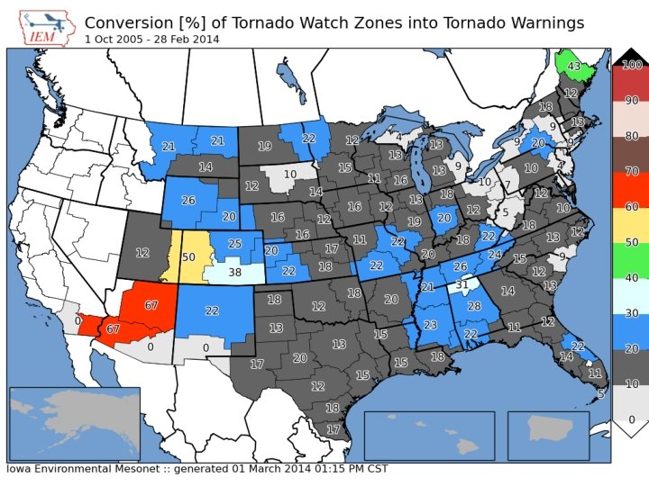
1 Oct 2005 – 28 Feb 2014 NWS Watches before a Warning (double accounting means totals can be over 100%) 54, 020 UGC Tornado Warnings Tornado Watch 69. 9% No Watch 15. 7% SVR Watch 14. 9% 409, 555 UGC No Watch SVR Warnings 41. 4% SVR Watch Tornado Watch 36. 4% 22. 5%
Chapter 2 MY STANDARD “STORM BASED” WARNINGS RANTING
Warning Process Evaluation Garden Variety Tornado We had better warn.
Warning Process Evaluation Yippee, we can use our fine training and draw a polygon!
Warning Process Evaluation I draw my fancy pants polygon out for 30 minutes. I’m done, right?
daryl’s here Warning Process Evaluation Gasp, I’m warning for 5 counties! Sirens will go off In all 5!
daryl’s stays asleep Warning Process Evaluation Warn. Gen clipping to the rescue!
Warning Process Evaluation Whoa, what happened?
Darn it daryl, I came here for stats (or free food), not altruistic hyperbole.
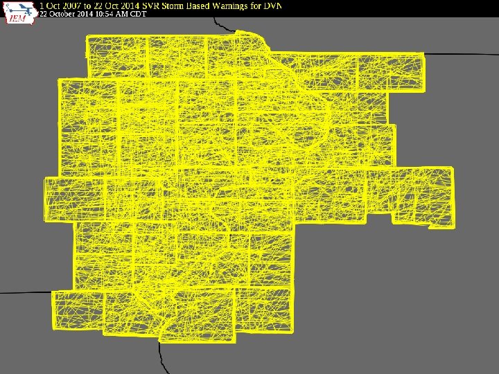
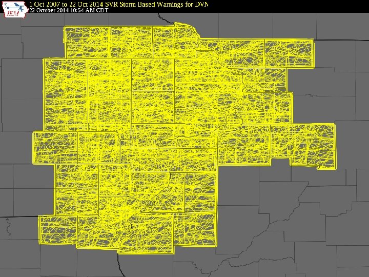
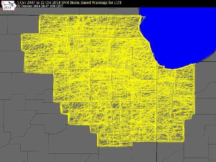
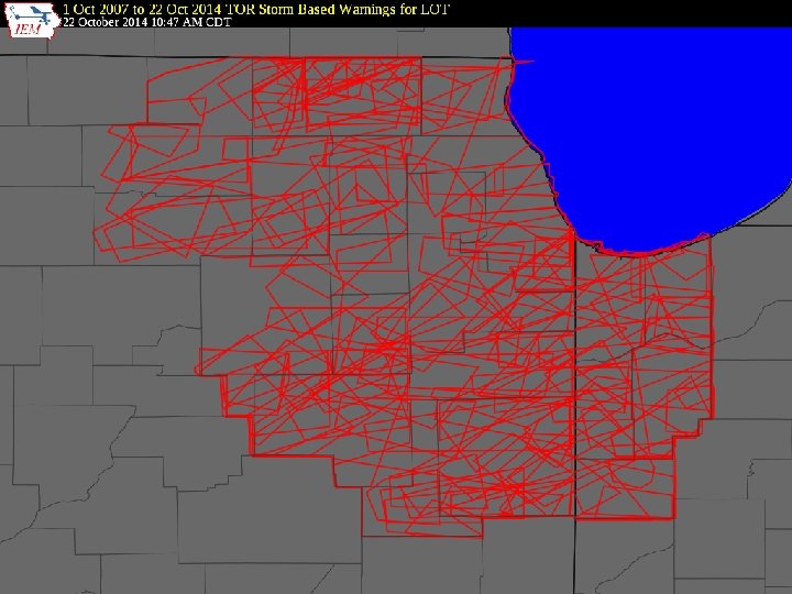
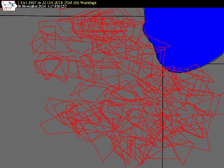
NWS County SVR/TOR Warnings Storm Based Warnings NEXRAD
NWS SBW SVR/TOR Warnings
1 Oct 2007, warnings changed http: //www. weather. gov/sbwarnings “Storm-Based / Warnings show the specific meteorological or hydrological threat area and are not restricted to geopolitical boundaries. ”
But what actually changed? NWS: Ignore the red, use the yellow 291 WUUS 53 KDMX 182302 SVRDMX IAC 007 -117 -125 -135 -181 -182345/O. NEW. KDMX. SV. W. 0171. 100618 T 2302 Z-100618 T 2345 Z/ BULLETIN - IMMEDIATE BROADCAST REQUESTED SEVERE THUNDERSTORM WARNING NATIONAL WEATHER SERVICE DES MOINES IA 602 PM CDT FRI JUN 18 2010 PRECAUTIONARY/PREPAREDNESS ACTIONS. . . MOVE TO AN INTERIOR ROOM AND STAY AWAY FROM WINDOWS. IF YOU ARE IN A MOBILE HOME. . . GET OUT NOW. . . AND SEEK SHELTER IN A REINFORCED BUILDING. A TORNADO WATCH REMAINS IN EFFECT FOR THE WARNED AREA. SEVERE THUNDERSTORMS CAN PRODUCE TORNADOES WITH LITTLE OR NO THE NATIONAL WEATHER SERVICE IN DES MOINES HAS ISSUED A WARNING. IF A TORNADO IS SPOTTED. . . IMMEDIATELY MOVE TO THE BASEMENT OR SMALL * SEVERE THUNDERSTORM WARNING FOR. . . NORTHWESTERN APPANOOSE COUNTY IN SOUTH CENTRAL IOWA. . . INTERIOR ROOM OF A REINFORCED BUILDING. NORTHEASTERN LUCAS COUNTY IN SOUTH CENTRAL IOWA. . . SOUTHWESTERN MARION COUNTY IN SOUTH CENTRAL IOWA. . . TORRENTIAL RAINFALL IS ALSO OCCURRING WITH THIS MONROE COUNTY IN SOUTH CENTRAL IOWA. . . STORM. . . AND MAY LEAD SOUTHEASTERN WARREN COUNTY IN SOUTH CENTRAL IOWA. . . TO FLASH FLOODING. DO NOT DRIVE YOUR VEHICLE THROUGH FLOODED * UNTIL 645 PM CDT ROADWAYS. TURN AROND DON'T DROWN. * AT 600 PM CDT. . . NATIONAL WEATHER SERVICE DOPPLER RADAR && INDICATED A SEVERE THUNDERSTORM CAPABLE OF PRODUCING GOLF BALL LAT. . . LON 4089 9310 4090 9313 4112 9357 SIZE HAIL. . . AND 4116 9357 4116 9358 4135 9335 4105 9272 DAMAGING WINDS IN EXCESS OF 60 MPH. THIS STORM WAS 4084 9301 LOCATED 10 TIME. . . MOT. . . LOC 2302 Z 300 DEG 28 KT 4114 9321 MILES NORTHEAST OF CHARITON. . . OR 36 MILES SOUTHEAST OF WIND. . . HAIL 60 MPH 1. 75 IN DES MOINES. . . AND MOVING SOUTHEAST AT 30 MPH. $$ * LOCATIONS IMPACTED INCLUDE. . . ALBIA. . . RUSSELL. . . MELROSE AND LOVILIA. SMALL
These aren’t the polygons you’re looking for (Maryland == 26, 000 sq km)
Oh daryl, you and your 1% type academic friends always focused on the outliers…. So another altruism: If less than 50% of warnings are “storm based”, can the program still keep its name?
Quiz Question #1 How do you cancel a portion of the warning? Answer: Cancel one of the counties in the warning! IAC 181 -182341/O. CAN. KDMX. SV. W. 0171. 000000 T 0000 Z-100618 T 2345 Z/. . . THE SEVERE THUNDERSTORM WARNING FOR SOUTHEASTERN WARREN COUNTY IS CANCELLED. . . IAC 007 -117 -125 -135 -182345/O. CON. KDMX. SV. W. 0171. 000000 T 0000 Z-100618 T 2345 Z/. . . A SEVERE THUNDERSTORM WARNING REMAINS IN EFFECT FOR SOUTHWESTERN MARION. . . MONROE. . . EASTERN LUCAS AND NORTHWESTERN APPANOOSE COUNTIES UNTIL 645 PM CDT. . .
Quiz Question #2 What’s wrong with this picture?
Bah, that is Davenport, we are fricken Romeoville
1 Oct 2007 – 28 Feb 2014: Number of Polygon Vertices (SVR+TOR) Percentage of Warnings 30 25 20 15 10 5 0 3 4 5 6 56. 5% 7 8 9 10 11 12 13 14 15 16 17 18 19 20 Number of Vertices 8. 7%
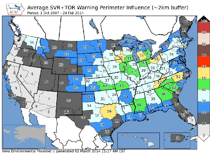
Lets get quantitative • Perimeter Influence – How much of the polygon perimeter coincides with a political boundary – Izzi’s suggested non-CWA political border change unimplemented • Size Reduction – How much smaller was the warning than the counties it was issued against.
~ 2 % of all warnings
Nationwide Average: 65%
Storm Based Warning size reduction by number of counties in warning Average Size Reduction [%] 90 80 70 60 50 40 30 20 10 0 1 2 3 4 5 6 7 8 9 10 11 12 13 14 15 16 17 18 19 20 21 22 23 25 29 30 33 Number of Counties included in SVR/TOR warning
Storm Based Warning # of Counties 35 Percent of Total 30 25 20 15 0. 7% of total 10 5 0 1 2 3 4 5 6 7 8 9 10 11 12 13 14 15 16 17 18 19 20 21 22 23 25 29 30 Number of Counties included in warning
Oh daryl, what about this? County Warning • Perimeter ratio is small • So lets compute another metric for the number of polygon vertices within 2 km of a political border
Overall Average: 75% Overall: 75%
Academic Thought Experiment Take TIME. . MOT. LOC and draw my own warning: 1. 30 min duration 2. ~10 km left 3. ~10 and increase to 30 km to the right Which will #win ?
Purple box is the warning from the automated algorithm
LOT’s TORs 2008 -2014 (based on LSR data) WEATHER BUREAU ACADEMIA Average Size (sq km) 880 909 Areal Verification 18. 1% 15. 2% Vertex County Intersection 64. 2% 20. 2% Size Reduction 76. 4% Didn’t Compute / n/a Perimeter Ratio 29% 28% Probability of Detection 0. 63 0. 55 False Alarm Rate 0. 70 Critical Success Index 0. 25 0. 24 Did the weather bureau #win?
Chapter 2 Summary • ~ 25% of TOR/SVR Warnings are 4 sided • Only ~ 2 % of all SVR/TOR warnings are pure county retracements • ~ 75% of polygon vertices are guided by county borders • SBWs have cut the size of warnings by over 60%, but the number of county based warnings has increased. • The Cubs will not win the World Series this year
Chapter 3 APPS & ARCHIVES
COOP Reports by WFO • Realtime processing of SHEF data • Sortable columns • SWE reports are included • Snow/Precip ratio is computed for QC help • Click on NWSLI to get all reports for the year • (Discuss DCP vs COOP)
IEM Cow • SBW Verification based on Local Storm Reports, not Storm Data • Provides geometry stats on polygon • Handy way to review event data • It is ‘live’ and accurate at the time of page load
IEM Raccoon • OAX’s Dan Nietfeld gave me the idea • Create simple and quick Powerpoints of SVR, TOR warning events • Intended use: – Internal Office review of events – Quick materials for presentations
NEXRAD Archives • 1 km composite every 5 minutes back to 1995 • Single site imagery since 1 Jan 2012 • Iowa NEXRADs are backfilled. • LOT recently backfilled as well! • GIS Ready!
VTEC Browser
NEXRAD Storm Attribute Archive
Fun Comparison, Here’s Miami KAMX
Other Archives of Interest • App to quickly view text products by center by date or range of dates (back to 2001 now) • Processed SHEF archive back to 2010 • Shapefile download of VTEC warnings and Local Storm Reports • Nearly complete archive of ASOS/AWOS processed data and raw METARs • Downloadable (atomic data) MOS archive since 2007 • Search VTEC Archive by Zone or by Point • Archived NWS WWA Map since 9 Apr 2013 • View METAR reports within NPW-type products • Map/Table summarizing data within Daily Climate Summary (CLI) Hopefully NCDC puts me out of (my misery / business) someday!
Time for Questions? Daryl Herzmann 515. 294. 5978 akrherz@iastate. edu