
ICESatGLAS Status at NSIDC Melinda Marquis NSIDC Product
- Slides: 32
ICESat/GLAS Status at NSIDC Melinda Marquis NSIDC Product Team Lead, AMSR-E and GLAS Science Team Meeting Oct. 13 -14, 2005 1 GLAS Science Team Meeting Melinda Marquis, NSIDC DAAC Oct. 13 -14, 2005
Outline • Progress (since last meeting, June 2 -3, 2005) • Ingested and started distributing Release-22 data • Distribution stats • Published Chris Shuman’s maps • Began subsetting • Began “BORG” table (Product-quality information about various ops periods) • Submitted Fall AGU abstract • Plans • Release 23 • Release 24 #21 • DEM • FAQ about multiple releases for users’ benefit 2 GLAS Science Team Meeting Melinda Marquis, NSIDC DAAC Oct. 13 -14, 2005
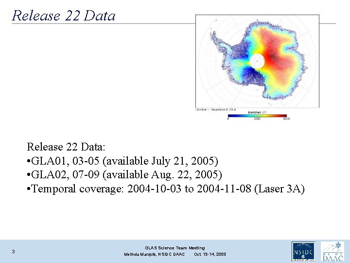
Release 22 Data: • GLA 01, 03 -05 (available July 21, 2005) • GLA 02, 07 -09 (available Aug. 22, 2005) • Temporal coverage: 2004 -10 -03 to 2004 -11 -08 (Laser 3 A) 3 GLAS Science Team Meeting Melinda Marquis, NSIDC DAAC Oct. 13 -14, 2005
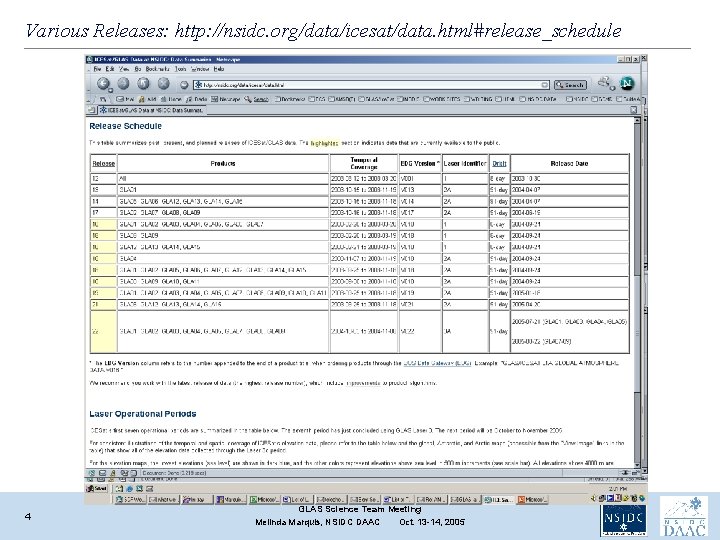
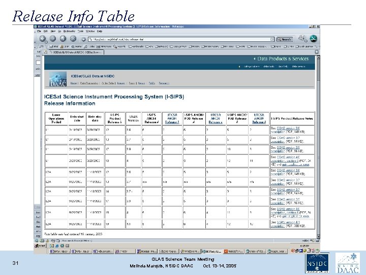
Various Releases: http: //nsidc. org/data/icesat/data. html#release_schedule 4 GLAS Science Team Meeting Melinda Marquis, NSIDC DAAC Oct. 13 -14, 2005
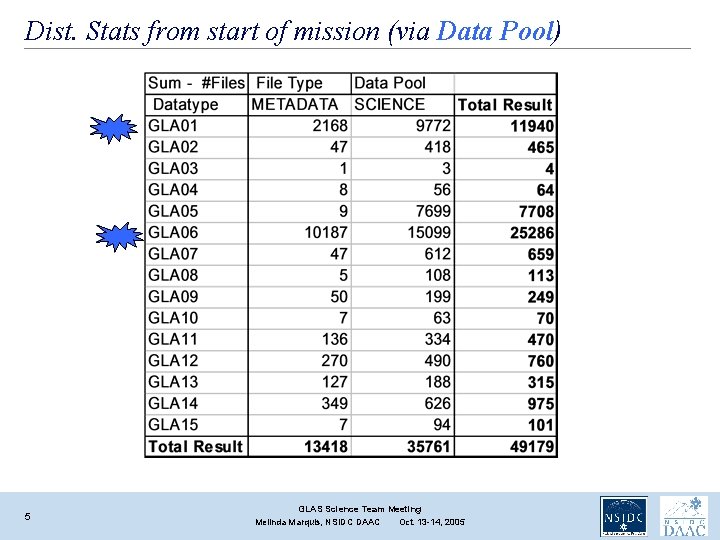
Dist. Stats from start of mission (via Data Pool) 5 GLAS Science Team Meeting Melinda Marquis, NSIDC DAAC Oct. 13 -14, 2005
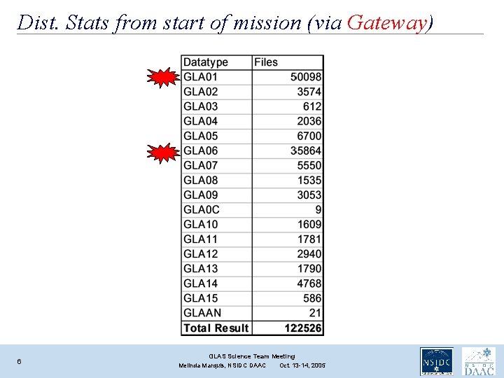
Dist. Stats from start of mission (via Gateway) 6 GLAS Science Team Meeting Melinda Marquis, NSIDC DAAC Oct. 13 -14, 2005
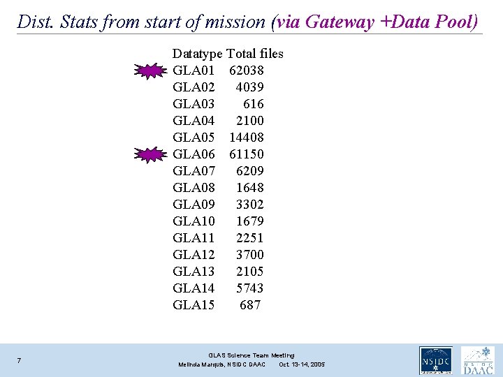
Dist. Stats from start of mission (via Gateway +Data Pool) Datatype Total files GLA 01 62038 GLA 02 4039 GLA 03 616 GLA 04 2100 GLA 05 14408 GLA 06 61150 GLA 07 6209 GLA 08 1648 GLA 09 3302 GLA 10 1679 GLA 11 2251 GLA 12 3700 GLA 13 2105 GLA 14 5743 GLA 15 687 7 GLAS Science Team Meeting Melinda Marquis, NSIDC DAAC Oct. 13 -14, 2005
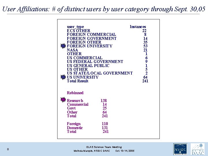
User Affiliations: # of distinct users by user category through Sept. 30, 05 user_type Instances ECS OTHER 22 FOREIGN COMMERCIAL 8 FOREIGN GOVERNMENT 14 FOREIGN OTHER 35 FOREIGN UNIVERSITY 53 NASA 21 OTHER 1 US COMMERCIAL 6 US FEDERAL GOVERNMENT 9 US GENERAL PUBLIC 1 US OTHER 5 US STATE/LOCAL GOVERNMENT 2 US UNIVERSITY 64 Total Result 241 Rebinned 8 Research Commercial Govt Other Total 138 14 25 64 241 Foreign Domestic Total 110 131 241 GLAS Science Team Meeting Melinda Marquis, NSIDC DAAC Oct. 13 -14, 2005
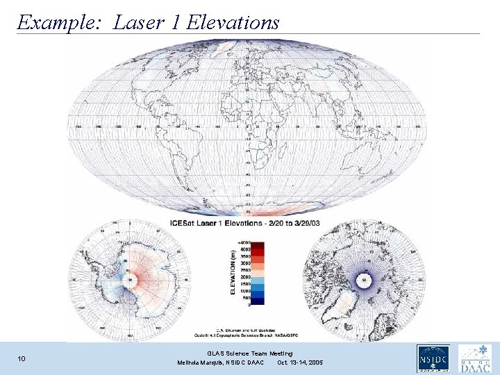
Published Chris Shuman’s maps Data summaries page: http: //nsidc. org/data/icesat/data. html#lasers • One elevation map/ops period • We also made smaller, optimized images of Chris’ maps to serve from our web site (with links to the full-resolution versions from an ftp server). 9 GLAS Science Team Meeting Melinda Marquis, NSIDC DAAC Oct. 13 -14, 2005
Example: Laser 1 Elevations 10 GLAS Science Team Meeting Melinda Marquis, NSIDC DAAC Oct. 13 -14, 2005
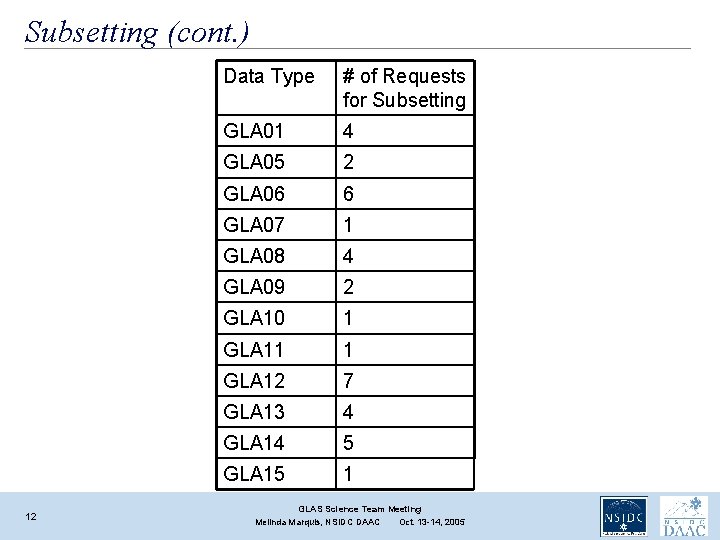
Subsetter published July 25 http: //nsidc. org/forms/glas_subset_form. html We provide subsetting for GLA 01, 05 -15. We’ve had 24 separate requests, from 18 distinct users. (4 users have made 2 requests; 1 users has made 3. ) Within a given “request, ” subsetting multiple data types (e. g. , GLA 06 and GLA 12) or subsetting a given data sets into multiple regions is common. 11 GLAS Science Team Meeting Melinda Marquis, NSIDC DAAC Oct. 13 -14, 2005
Subsetting (cont. ) 12 Data Type # of Requests for Subsetting GLA 01 4 GLA 05 2 GLA 06 6 GLA 07 1 GLA 08 4 GLA 09 2 GLA 10 1 GLA 11 1 GLA 12 7 GLA 13 4 GLA 14 5 GLA 15 1 GLAS Science Team Meeting Melinda Marquis, NSIDC DAAC Oct. 13 -14, 2005
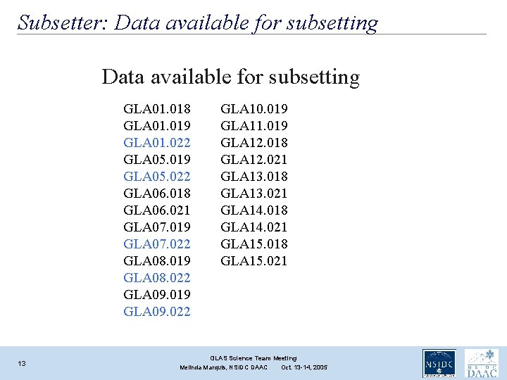
Subsetter: Data available for subsetting GLA 01. 018 GLA 01. 019 GLA 01. 022 GLA 05. 019 GLA 05. 022 GLA 06. 018 GLA 06. 021 GLA 07. 019 GLA 07. 022 GLA 08. 019 GLA 08. 022 GLA 09. 019 GLA 09. 022 13 GLA 10. 019 GLA 11. 019 GLA 12. 018 GLA 12. 021 GLA 13. 018 GLA 13. 021 GLA 14. 018 GLA 14. 021 GLA 15. 018 GLA 15. 021 GLAS Science Team Meeting Melinda Marquis, NSIDC DAAC Oct. 13 -14, 2005
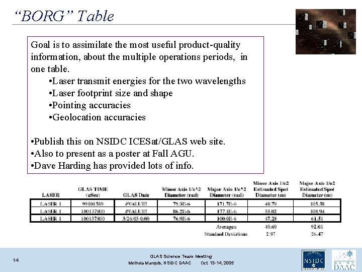
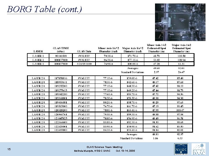
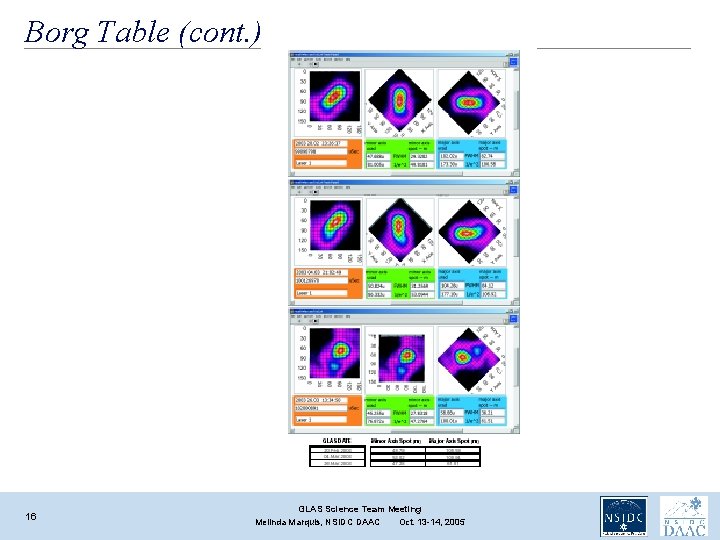
“BORG” Table Goal is to assimilate the most useful product-quality information, about the multiple operations periods, in one table. • Laser transmit energies for the two wavelengths • Laser footprint size and shape • Pointing accuracies • Geolocation accuracies • Publish this on NSIDC ICESat/GLAS web site. • Also to present as a poster at Fall AGU. • Dave Harding has provided lots of info. 14 GLAS Science Team Meeting Melinda Marquis, NSIDC DAAC Oct. 13 -14, 2005
BORG Table (cont. ) 15 GLAS Science Team Meeting Melinda Marquis, NSIDC DAAC Oct. 13 -14, 2005
Borg Table (cont. ) 16 GLAS Science Team Meeting Melinda Marquis, NSIDC DAAC Oct. 13 -14, 2005
AGU Abstract submitted Authors: Melinda, Dave H. , Bob S. , Jim Abshire, and the GLAS Instrument and Science Teams Title: Ice, Cloud, and land Elevation Satellite (ICESat) Data Quality Information The Geoscience Laser Altimeter System (GLAS) instrument aboard the Ice, Cloud, and land Elevation (ICESat) satellite launched on 12 January 2003. The primary objective of the ICESat mission is to provide global measurements of polar ice sheet elevation to discern changes in ice volume (mass balance) over time. Secondary objectives of the mission are to measure sea ice roughness and thickness, cloud and atmospheric properties, land topography, vegetation canopy heights, ocean surface topography, and surface reflectivity. The GLAS instrument has three lasers, each of which has a 1064 nm laser channel for surface altimetry and dense cloud heights, and a 532 nm lidar channel for the vertical distribution of clouds and aerosols. The three lasers have been operated one at a time, sequentially throughout the mission. To extend mission life, the current operational mode has included 33 -day to 56 -day campaigns, several times per year. As of abstract submission, a total of seven operational campaigns have been completed. Multiple releases of the ICESat/GLAS data are now available at the National Snow and Ice Data Center (http: //nsidc. org/data/icesat/). Here, we present data quality information for the several operational campaigns. The metadata table includes: Laser transmit energies for the two wavelengths; laser footprint size and shape; and pointing and geolocation accuracies. We also provide up-to-date information about the product release versions for each of the 15 data products. 17 GLAS Science Team Meeting Melinda Marquis, NSIDC DAAC Oct. 13 -14, 2005
Plans • Next data release: Rel#23 (elev. ) products: GLA 06, and 12 -15, for Laser 3 A period. • Will have improved pointing data compared to rel#22 elev products. • Bob S. working to understand why pointing correction for rel#23 (Laser 3 A) differs from that of Laser 2 A period • Rel. 24 will contain format and file size changes • Subsetter changes (From Kris’s talk, slide #13) v. Record lengths have changed for GLA 05 -15 • V 5. 0 libraries will not work with v 4. x data and visa versa – bear this in mind when exporting libraries to run F 90 routines 18 GLAS Science Team Meeting Melinda Marquis, NSIDC DAAC Oct. 13 -14, 2005
Plans • DEM • We’ll review what John Di. Marzio has and provide further input (in addition to input from Ted Scambos, Oct. 8) • FAQ re: multiple releases • Action item from June STM • I sent draft to Bob S. June 13 • Awaiting Bob’s reply • Will this be OBE by Rel#24? 19 GLAS Science Team Meeting Melinda Marquis, NSIDC DAAC Oct. 13 -14, 2005
New (interim) POC at NSIDC Doug Fowler dfowler@nsidc. org 303 -735 -1357 20 GLAS Science Team Meeting Melinda Marquis, NSIDC DAAC Oct. 13 -14, 2005
Summary • • • 21 We’re distributing rel#22 data We’re providing subsetting We’re looking for DEM We’re looking for rel#23 (GLA 06, 12 -15) We’re looking for rel#24 (one release with all public data) We’re working on Borg Table GLAS Science Team Meeting Melinda Marquis, NSIDC DAAC Oct. 13 -14, 2005
Backup Slides 22 GLAS Science Team Meeting Melinda Marquis, NSIDC DAAC Oct. 13 -14, 2005
Ted’s Input re: DEM, Oct. , 8 I think the best format is an image-like format, with elevations reported as integers (or reals) at each grid node. This is the most-used format for the RAMP DEM of Antarctica. However, it will also be valid and useful for some to report the data in a compressed ascii "lat long elev geoid" table, one line for each grid cell. This second format may be very large (10 s of gigabytes) but is easily subsetted upon request. The image-format is more compact, but it does require good geo-spatial handling tools to manipulate. So I think both formats. Other information can be incorporated in ascii 'read me' files and the websites. Antarctica: Polar Stereographic, -71 plane of projection, 0 longitude = y axis, WGS 84 ellipsoid. That is, identical to RAMP, MOA, and a host of other maps. Greenland: Polar Sterographic, -70 plane of projection, 45 longitude = yaxis, WGS 84 ellipsoid (NOT TOPEX, NOT Hughes-SSM/I ellipsoids. ) This is the emerging US standard for Greenland image maps (e. g. , Joughin, Kwok radar maps). The MOG mosaic is also in this projection. I think Terry can provide further corner-point and grid dimension details. 23 GLAS Science Team Meeting Melinda Marquis, NSIDC DAAC Oct. 13 -14, 2005
FAQ about multiple releases Hi, Bob, At the last GLAS STM, I took an action item to sketch a draft explanation for users explaining why it's so difficult to have just one release of all data. I think if we explain the reason for all the multiple releases, it'll diminish users' frustration caused by the confusion. My draft below is meant only as a starting point from which you can write a more comprehensive explanation. We might post this explanation on any of the following URLs. Let me know if you have a suggestion on where you'd like to see it. http: //nsidc. org/data/icesat/data. html http: //nsidc. org/data/icesat/detailed_disclaimer. html http: //nsidc. org/data/icesat/data. html#release_schedule "Multiple releases of the ICESat/GLAS data are currently available as the science team works to provide the highest possible quality data to the public. Some time periods have been corrected for certain issues, while other time periods haven't had such corrections applied to them (for lack of time as of now, but will be corrected eventually). Various complexities of this mission have occupied the time of the science team and data producers, preventing them for creating one release of data in which all data values have been treated equally. Different laser operating temperatures and different satellite modes (airplane vs. sailboat) are examples of the factors that have varied across the time of the mission. In addition to the various types of corrections applied to the data, the EDG client (the search and order interface at NSIDC via which many users order data) has limitations that mean an additional, older release of data may still be available to the public even though an improved release for certain dates is available also. For instance, Rel#18 data for Fall 2003 (laser 2 A) are still available to the public, even though Rel#19 data for those same dates are available: This is because Rel #18 covers two time periods (both Fall 2003 and Spring 2003, during which laser 1 operated). Rel #19 doesn't cover the laser 1 time period (nor does any higher-level public release of data). Thus NSIDC continues to provide public access to Rel #18 data for Spring 2003. The EDG client doesn't allow for only certain periods of a given release to be available. In order for NSIDC to provide Rel#18 data for Spring 2003, we must also provide Rel #18 data for Fall 2003. Users are urged to use the highest-level release for any given date of data. The table at XXX URL (the Excel table I emailed you this morning) provides information about the laser operations during the various campaigns of the ICESat mission. " Thanks, Melinda 24 GLAS Science Team Meeting Melinda Marquis, NSIDC DAAC Oct. 13 -14, 2005
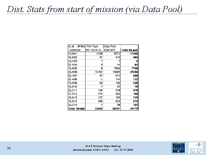
Dist. Stats from start of mission (via Data Pool) 25 GLAS Science Team Meeting Melinda Marquis, NSIDC DAAC Oct. 13 -14, 2005
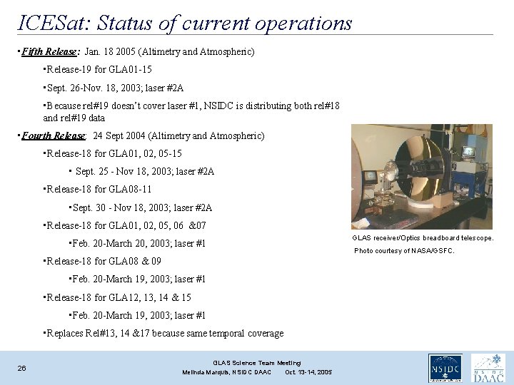
ICESat: Status of current operations • Fifth Release: Jan. 18 2005 (Altimetry and Atmospheric) • Release-19 for GLA 01 -15 • Sept. 26 -Nov. 18, 2003; laser #2 A • Because rel#19 doesn’t cover laser #1, NSIDC is distributing both rel#18 and rel#19 data • Fourth Release: 24 Sept 2004 (Altimetry and Atmospheric) • Release-18 for GLA 01, 02, 05 -15 • Sept. 25 - Nov 18, 2003; laser #2 A • Release-18 for GLA 08 -11 • Sept. 30 - Nov 18, 2003; laser #2 A • Release-18 for GLA 01, 02, 05, 06 &07 • Feb. 20 -March 20, 2003; laser #1 • Release-18 for GLA 08 & 09 • Feb. 20 -March 19, 2003; laser #1 • Release-18 for GLA 12, 13, 14 & 15 • Feb. 20 -March 19, 2003; laser #1 • Replaces Rel#13, 14 &17 because same temporal coverage 26 GLAS Science Team Meeting Melinda Marquis, NSIDC DAAC Oct. 13 -14, 2005 GLAS receiver/Optics breadboard telescope. Photo courtesy of NASA/GSFC.
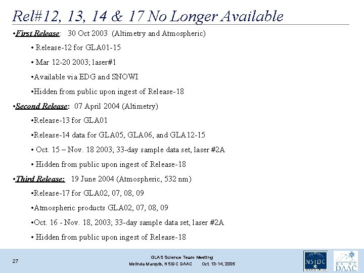
Rel#12, 13, 14 & 17 No Longer Available • First Release: 30 Oct 2003 (Altimetry and Atmospheric) • Release-12 for GLA 01 -15 • Mar 12 -20 2003; laser#1 • Available via EDG and SNOWI • Hidden from public upon ingest of Release-18 • Second Release: 07 April 2004 (Altimetry) • Release-13 for GLA 01 • Release-14 data for GLA 05, GLA 06, and GLA 12 -15 • Oct. 15 – Nov. 18 2003; 33 -day sample data set, laser #2 A • Hidden from public upon ingest of Release-18 • Third Release: 19 June 2004 (Atmospheric, 532 nm) • Release-17 for GLA 02, 07, 08, 09 • Atmospheric products GLA 02, 07, 08, 09 • Oct. 16 - Nov. 18, 2003; 33 -day sample data set, laser #2 A • Hidden from public upon ingest of Release-18 27 GLAS Science Team Meeting Melinda Marquis, NSIDC DAAC Oct. 13 -14, 2005
Ordering ICESat/GLAS Data from NSIDC Data Pool Search ‘N Order Web Interface (SNOWI) EOS Data Gateway (EDG) Subscription http: //nsidc. org/data/icesat/order. html 28 GLAS Science Team Meeting Melinda Marquis, NSIDC DAAC Oct. 13 -14, 2005
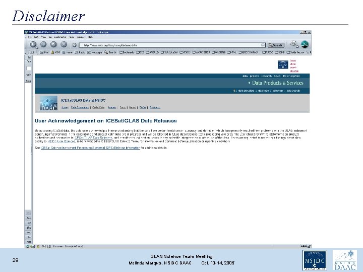
Disclaimer 29 GLAS Science Team Meeting Melinda Marquis, NSIDC DAAC Oct. 13 -14, 2005
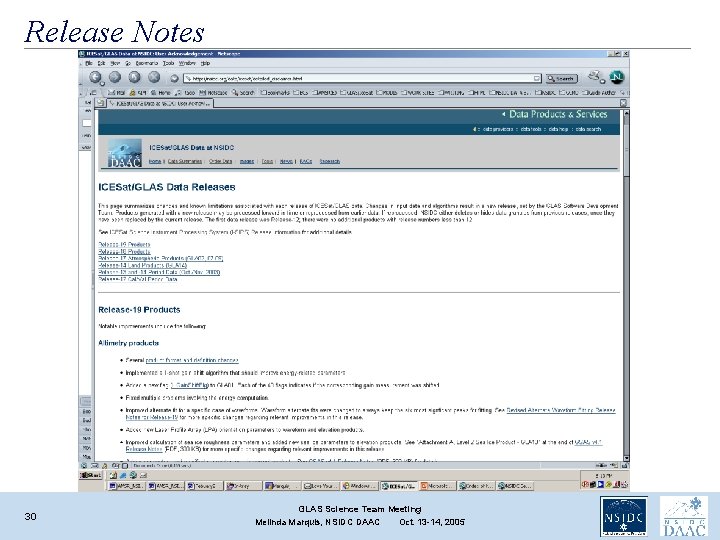
Release Notes 30 GLAS Science Team Meeting Melinda Marquis, NSIDC DAAC Oct. 13 -14, 2005
Release Info Table 31 GLAS Science Team Meeting Melinda Marquis, NSIDC DAAC Oct. 13 -14, 2005
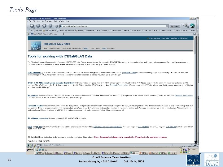
Tools Page 32 GLAS Science Team Meeting Melinda Marquis, NSIDC DAAC Oct. 13 -14, 2005