IBM T J Watson Research Center Developing Better
IBM T. J. Watson Research Center Developing Better Forecasts: An analysis of two storms during summer 2009 using the high resolution WRF model and observations on July 7 and August 18 Elena Novakovskaia, IBM Brandon Hertell, Consolidated Edison © 2009 IBM Corporation

IBM T. J. Watson Research Center Introduction • Focus is on detailed analysis of high-impact weather events for decision making, emergency response and preparedness, and planning for storm recovery actions – utility companies; – private transportation; – emergency management by municipal and state government agencies; – and many more. • High resolution localized numerical weather predictions provide information on the multi-faceted aspects of severe weather events and have advantages for allocation of resources with sufficient lead time • Operational mesoscale prediction system, called “Deep Thunder”, has been developed at the IBM Thomas J. Watson Research Center. It is implemented and applied to business problems in a number of metropolitan areas in the US, including New York City. • To assess the uncertainties in high-resolution mesoscale forecasts, we utilize ensemble-based probabilistic predictions suitable for risk analysis, and examine the most extreme and damaging scenarios. • We analyze each event - whether the model forecast was correct or not - to find information that would enable the model to provide a better forecast in the future. © 2009 IBM Corporation

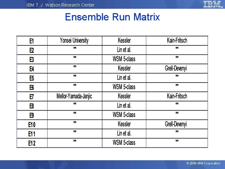
IBM T. J. Watson Research Center Methodology • Multiple forecast realizations in the ensemble are created using a variety of physical process schemes within the WRF-ARW model and the same initial and boundary conditions IC/BC Decision Making based on Probabilistic Forecasting © 2009 IBM Corporation
IBM T. J. Watson Research Center Ensemble Run Matrix © 2009 IBM Corporation

IBM T. J. Watson Research Center Simulation Model Domain 3 • WRF/ARW V 3. 1. 1 model • Domain: – Nested grid: 18/6/2 km (76 x 42) – Centered at 41°N, 73. 5°W – 42 vertical levels • Radiation: – Longwave – RRTM – Shortwave – Goddard 3 • Noah Land Surface Model • Initial and Boundary conditions: – NAM (12 km) – SST RTG (0. 5 deg) 2 1 © 2009 IBM Corporation
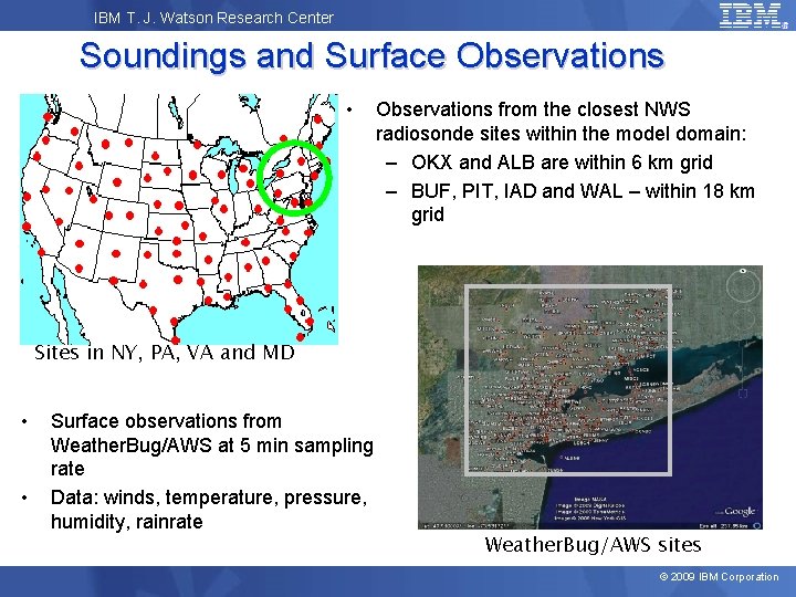
IBM T. J. Watson Research Center Soundings and Surface Observations • Observations from the closest NWS radiosonde sites within the model domain: – OKX and ALB are within 6 km grid – BUF, PIT, IAD and WAL – within 18 km grid Sites in NY, PA, VA and MD • • Surface observations from Weather. Bug/AWS at 5 min sampling rate Data: winds, temperature, pressure, humidity, rainrate Weather. Bug/AWS sites © 2009 IBM Corporation

IBM T. J. Watson Research Center Case Study: Storm of July 7, 2009 © 2009 IBM Corporation

IBM T. J. Watson Research Center July 7, 2009 • • • It had been a stormy day in the NYC area At 7: 45 pm NWS Upton took down the Severe T-Storm Watch as all thunderstorm activity was dying out and moving away. At 9: 30 pm a broken line of thunderstorms entered and moved across Orange & Rockland County – strengthening rapidly as they moved east through approx 10: 30 pm. • • • Radar Image July 7, 2009 at 11: 36 pm EDT At 11: 09 pm NWS issued a Severe Thunderstorm Warning for Rockland Westchester County Between 11: 27 pm – 11: 53 pm this storm moved through Westchester County. 11: 34 pm a tornado warning was issued for Westchester County based on the radar signature. © 2009 IBM Corporation

IBM T. J. Watson Research Center Microburst Event • That powerful and highly localized storm cell hit the city of Yonkers in Westchester County, NY. • Fallen trees caused power outages and road closings, local rescue teams rushed to help the recovery. • In the morning on July 8, 2009 Yonkers Third Deputy Fire Chief Ed Cucolo said: “We, the fire and police department are spread very thin. It’s a mess. ” • Extra manpower was called in by the Fire Department, including 16 bucket trucks from Consolidated Edison on the way in the city to help in the cleanup, Cucolo said. • Due to road closings and outages, summer schools were cancelled, emergency services, including distribution of ice, were provided to residents Photo by Adrienne Leptich, WFO NY, New York © 2009 IBM Corporation
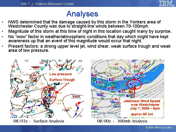
IBM T. J. Watson Research Center Analyses • • NWS determined that the damage caused by this storm in the Yonkers area of Westchester County was due to straight-line winds between 70 -100 mph. Magnitude of this storm at this time of night in this location caught many by surprise. No “wow” factor in weather/atmospheric conditions that day which might have kept awareness up that an event of this magnitude would occur that night. Present factors: a strong upper level jet, wind shear, weak surface trough and weak area of low pressure. Low pressure Surface Trough Jetstream Wind Speed over Westchester July 7, 2009 – 8 pm approx 85 knt 08/03 z - Surface Analysis 08/00 z - 300 mb Analysis © 2009 IBM Corporation

IBM T. J. Watson Research Center Soundings Not impressive • • CAPE has decreased, LI = 0. Both soundings indicate strong upper level jet Between 12 z and 00 z – increased wind shear, helicity and humidity at lower levels © 2009 IBM Corporation

IBM T. J. Watson Research Center Simulated Profiles for NWS site in Upton, NY INIT E 1 E 2 E 3 E 4 E 5 E 6 E 7 E 8 E 9 E 10 E 11 E 12 OBS 08/00 z • • Winds (in knots) up to 100 mb level at initial time (07/08/12 z), each ensemble member at 07/08/00 z, and observations at 07/08/00 z Uncertainties in wind speed and direction at levels below 750 mb; most near-surface wind veering for MYI-K-GD (E 10) and near 900 -800 mb for MYJ-W-KF (E 9) © 2009 IBM Corporation
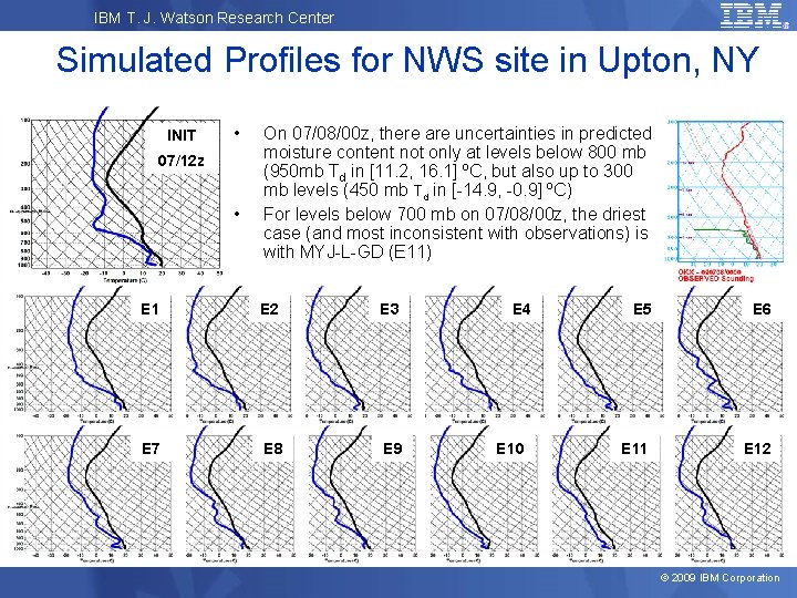
IBM T. J. Watson Research Center Simulated Profiles for NWS site in Upton, NY INIT • 07/12 z • On 07/08/00 z, there are uncertainties in predicted moisture content not only at levels below 800 mb (950 mb Td in [11. 2, 16. 1] ºC, but also up to 300 mb levels (450 mb Td in [-14. 9, -0. 9] ºC) For levels below 700 mb on 07/08/00 z, the driest case (and most inconsistent with observations) is with MYJ-L-GD (E 11) E 1 E 2 E 3 E 7 E 8 E 9 E 4 E 10 E 5 E 6 E 11 E 12 © 2009 IBM Corporation

IBM T. J. Watson Research Center Yonkers, NY on July 7, 2009 • • For YSU-W-KF (E 3) sharp wind speed change and more than average drop in temperature YSU scheme in combination with GD has dry bias and higher surface pressure © 2009 IBM Corporation
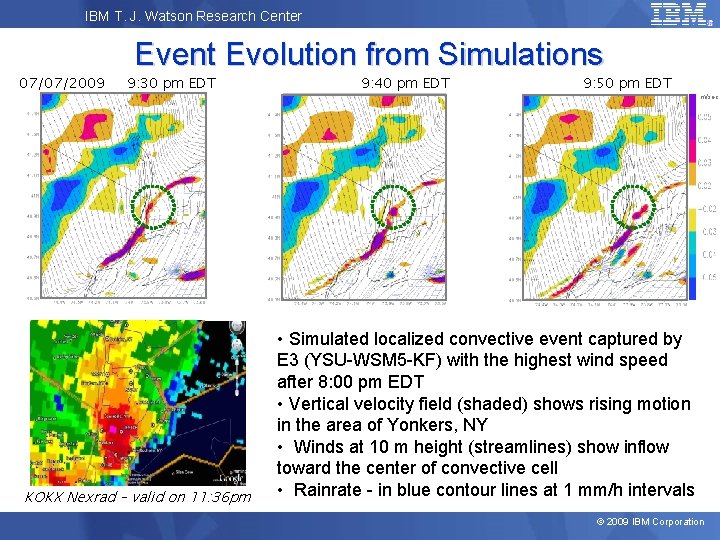
IBM T. J. Watson Research Center 07/07/2009 Event Evolution from Simulations 9: 30 pm EDT KOKX Nexrad – valid on 11: 36 pm 9: 40 pm EDT 9: 50 pm EDT m/sec • Simulated localized convective event captured by E 3 (YSU-WSM 5 -KF) with the highest wind speed after 8: 00 pm EDT • Vertical velocity field (shaded) shows rising motion in the area of Yonkers, NY • Winds at 10 m height (streamlines) show inflow toward the center of convective cell • Rainrate - in blue contour lines at 1 mm/h intervals © 2009 IBM Corporation
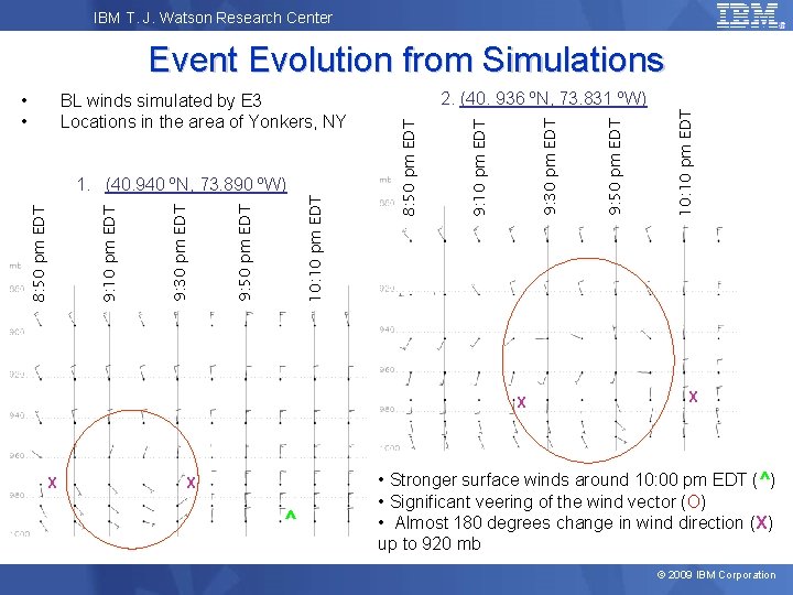
IBM T. J. Watson Research Center Event Evolution from Simulations X X X ^ 10: 10 pm EDT 9: 50 pm EDT 9: 30 pm EDT 9: 10 pm EDT 8: 50 pm EDT 1. (40. 940 ºN, 73. 890 ºW) 2. (40. 936 ºN, 73. 831 ºW) 9: 10 pm EDT BL winds simulated by E 3 Locations in the area of Yonkers, NY 8: 50 pm EDT • • X • Stronger surface winds around 10: 00 pm EDT (^) • Significant veering of the wind vector (O) • Almost 180 degrees change in wind direction (X) up to 920 mb © 2009 IBM Corporation
IBM T. J. Watson Research Center Case Study: Storm of August 18, 2009 © 2009 IBM Corporation
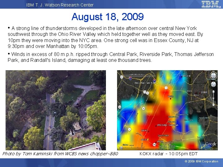
IBM T. J. Watson Research Center August 18, 2009 • A strong line of thunderstorms developed in the late afternoon over central New York southwest through the Ohio River Valley which held together well as they moved east. By 10 pm they were moving into the NYC area. One strong cell was in Essex County, NJ at 9: 30 pm and over Manhattan by 10: 05 pm. • Winds in excess of 80 m. p. h. ripped through Central Park, Riverside Park, Thomas Jefferson Park, and Randall's Island, damaging at least one thousand trees. Photo by Tom Kaminski from WCBS news chopper-880 KOKX radar – 10: 05 pm EDT © 2009 IBM Corporation
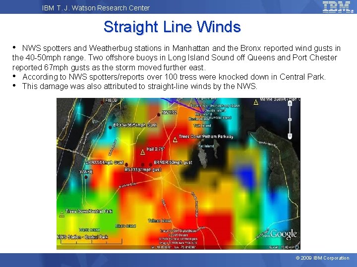
IBM T. J. Watson Research Center Straight Line Winds • NWS spotters and Weatherbug stations in Manhattan and the Bronx reported wind gusts in the 40 -50 mph range. Two offshore buoys in Long Island Sound off Queens and Port Chester reported 67 mph gusts as the storm moved further east. • According to NWS spotters/reports over 100 tress were knocked down in Central Park. • This damage was also attributed to straight-line winds by the NWS. © 2009 IBM Corporation
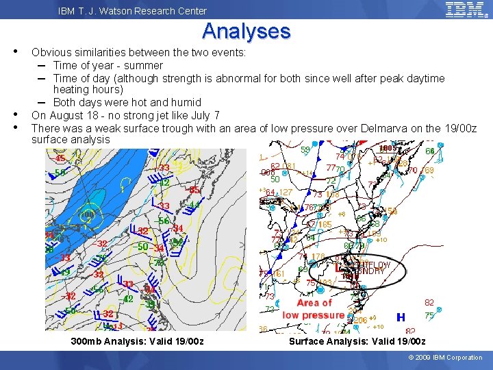
IBM T. J. Watson Research Center • • • Analyses Obvious similarities between the two events: – Time of year - summer – Time of day (although strength is abnormal for both since well after peak daytime heating hours) – Both days were hot and humid On August 18 - no strong jet like July 7 There was a weak surface trough with an area of low pressure over Delmarva on the 19/00 z surface analysis 300 mb Analysis: Valid 19/00 z Surface Analysis: Valid 19/00 z © 2009 IBM Corporation
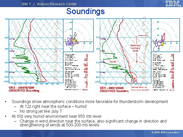
IBM T. J. Watson Research Center Soundings • • Soundings show atmospheric conditions more favorable for thunderstorm development – At 12 z right near the surface – humid – No strong jet like July 7 At 00 z very humid environment near 850 mb level – Change in wind direction near the surface, also significant change in direction and strengthening of winds at 500 -200 mb levels © 2009 IBM Corporation
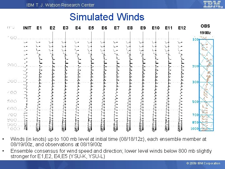
IBM T. J. Watson Research Center Simulated Winds INIT E 1 E 2 E 3 E 4 E 5 E 6 E 7 E 8 E 9 E 10 E 11 E 12 OBS 19/00 z • • Winds (in knots) up to 100 mb level at initial time (08/18/12 z), each ensemble member at 08/19/00 z, and observations at 08/19/00 z Ensemble consensus for wind speed and direction; lower level winds below 800 mb slightly stronger for E 1, E 2, E 4, E 5 (YSU-K, YSU-L) © 2009 IBM Corporation
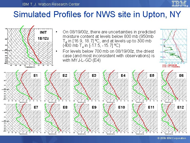
IBM T. J. Watson Research Center Simulated Profiles for NWS site in Upton, NY INIT • 18/12 z • On 08/19/00 z, there are uncertainties in predicted moisture content at levels below 800 mb (950 mb Td in [16. 9, 18. 7] ºC, and at levels up to 300 mb (400 mb Td in [-17. 5, -15. 7] ºC) For levels below 700 mb on 08/19/00 z, the driest case (and most inconsistent with observations) is with MYJ-L-GD (E 4) E 1 E 2 E 3 E 4 E 5 E 6 E 7 E 8 E 9 E 10 E 11 E 12 © 2009 IBM Corporation
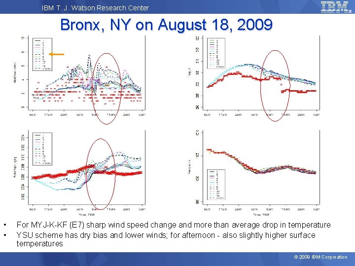
IBM T. J. Watson Research Center Bronx, NY on August 18, 2009 • • For MYJ-K-KF (E 7) sharp wind speed change and more than average drop in temperature YSU scheme has dry bias and lower winds; for afternoon - also slightly higher surface temperatures © 2009 IBM Corporation
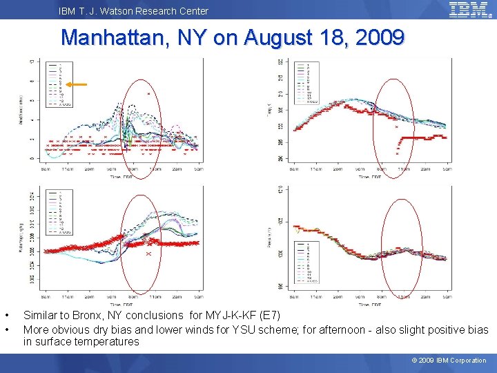
IBM T. J. Watson Research Center Manhattan, NY on August 18, 2009 • • Similar to Bronx, NY conclusions for MYJ-K-KF (E 7) More obvious dry bias and lower winds for YSU scheme; for afternoon - also slight positive bias in surface temperatures © 2009 IBM Corporation
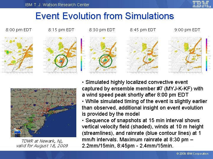
IBM T. J. Watson Research Center Event Evolution from Simulations 8: 00 pm EDT 8: 15 pm EDT TDWR at Newark, NJ, valid for August 18, 2009 8: 30 pm EDT 8: 45 pm EDT 9: 00 pm EDT • Simulated highly localized convective event captured by ensemble member #7 (MYJ-K-KF) with a wind speed peak shortly after 8: 00 pm EDT • While simulated timing of the event is slightly earlier than observed, additional insight on event evolution is provided by the model • Sequence of snapshots at 15 min interval shows vertical velocity field (shaded), winds at 10 m height (streamlines), and rainrate (blue contour lines) at 1 mm/h intervals. Maximum rainrate at 8: 30 pm – 2. 2 mm/15 min, 8: 45 pm - 2. 4 mm/15 min. © 2009 IBM Corporation
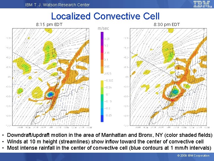
IBM T. J. Watson Research Center Localized Convective Cell 8: 15 pm EDT m/sec 8: 30 pm EDT • Downdraft/updraft motion in the area of Manhattan and Bronx, NY (color shaded fields) • Winds at 10 m height (streamlines) show inflow toward the center of convective cell • Most intense rainfall in the center of convective cell (blue contours at 1 mm/h intervals) © 2009 IBM Corporation
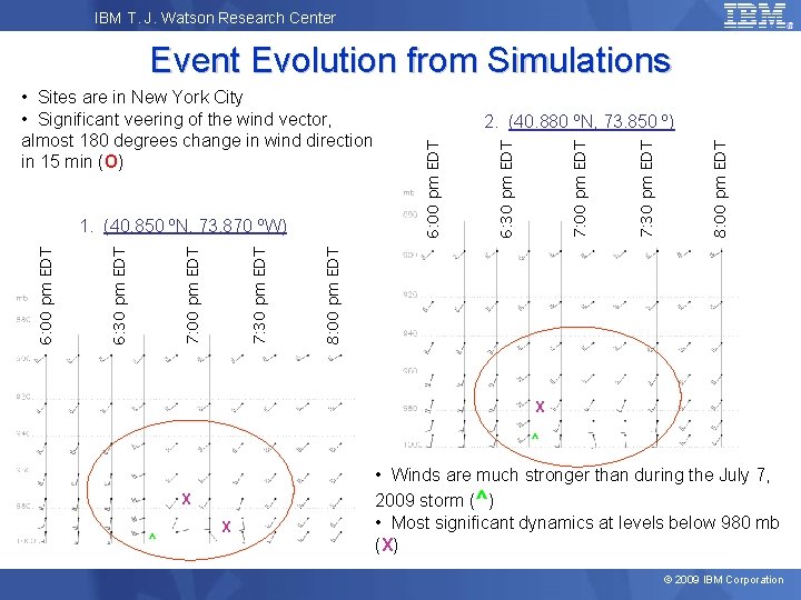
IBM T. J. Watson Research Center Event Evolution from Simulations 8: 00 pm EDT 7: 30 pm EDT 7: 00 pm EDT 6: 30 pm EDT 6: 00 pm EDT 1. (40. 850 ºN, 73. 870 ºW) 2. (40. 880 ºN, 73. 850 º) 6: 00 pm EDT • Sites are in New York City • Significant veering of the wind vector, almost 180 degrees change in wind direction in 15 min (O) X ^ X • Winds are much stronger than during the July 7, 2009 storm (^) • Most significant dynamics at levels below 980 mb (X) © 2009 IBM Corporation
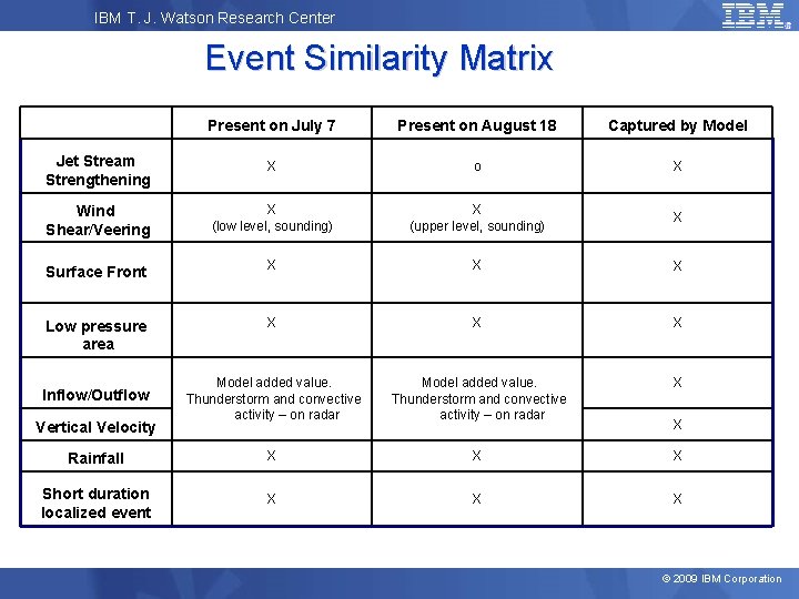
IBM T. J. Watson Research Center Event Similarity Matrix Present on July 7 Present on August 18 Captured by Model Jet Stream Strengthening X o X Wind Shear/Veering X (low level, sounding) X (upper level, sounding) X Surface Front X X X Low pressure area X X X Model added value. Thunderstorm and convective activity – on radar X Rainfall X X X Short duration localized event X X X Inflow/Outflow Vertical Velocity X © 2009 IBM Corporation
IBM T. J. Watson Research Center Conclusion • Meteorological assessment of the event based on soundings and surface observations shows a few similarities in atmospheric conditions between the two storms • Ensemble forecasts were performed and validated against observations; the closest matching scenarios provided an additional insight on the events • There are storm features at smaller scales that were revealed through simulations. While both events were very localized, simulations at 2 km resolution were able to capture additional details of these storms • Events were different enough, so that analysis of the first event would not be sufficient to provide a better forecast for the second event. For the considered storms, the physical processes schemes of the most matching run were different (YSU-WSM 5 -KF and MYJ-K-KF). Using an ensemble with different schemes to simulate multiple scenarios for a high-impact weather event has an advantage of capturing the worst case scenario and estimating its probability. • Our analysis indicates that a high-resolution mesoscale ensemble, which is based on a variety of physical schemes, is a valuable tool for developing better forecasts. © 2009 IBM Corporation
- Slides: 30