IAARAS Radio Science Experiments in ChangE Lunar Mission


 •")


 With Very Long")

 Main focus:")


 Global Crust Thickness Thinnest middle scale crust basins")


 EOP,")


: Martian Radio Ranging, scince 2016 with INSIGHT mission of NASA ~2")

- Slides: 51
@ IAA/RAS Radio Science Experiments in Chang’E Lunar Mission & Chang’E-3/4 Lunar Radio Ranging Jinsong PING, Planetary Radio Science Team National Astronomical Observatory of CAS, Datun Rd. 20 A, Beijing, China; Contact: jsping@bao. ac. cn
Content Outline Radio science experiments have been involved in all of the CE-n lunar missions. Where in Chang’E-3 landing mission, 2 & 3 -way lunar radio-phase ranging (LRR) was developed and tested at X-band of 8470 MHz by radio science. This LRR method can become a new space geodetic technique to study the geodynamics, lunar dynamics, and to test theory of relativity, as LLR did. We successfully realized this new kind of space technique, in CE-3 mission and the preliminary result is presented here.
Three Phase of Chinese Lunar Exploration 1. 概况 Orbiting CE-1/2 2004 -2011 Landing CE-2/3/4 2010 -2018 Sampling Return CE-4/5 2017 -2020
Radio Science in Lunar & Deep Space Mission May Affect Navigation (Basic Works) • lunar/planetary gravity, topography • Lunar/Planets rotation and nutation • Celestial reference frame (tie ? ) • Planetary atmosphere, Ring… • Solar winds • Test experiments of relativity: Cassini Huygens Advantages: share TT&C system, without new payload Disadvantages: need state-of-art time-frequency techniques Joint the Explorations of Planetary Radio Sciences with Planetary Geodesy/Geophysics/Geodynamics Explorations
Mercury Large liquid core, global contraction Topography, gravity field, the Ph. L Venus Gravity field rotation changes, atm. ultra-fast rotating Mars Whether the plate is divided? Topographic dichotomy, tides Polar cap(shape & gravity change) gravity field, polar motion, nutation Mars shock? Reveal the planetary origin & evolution, Topography, gravity field & change, Rotation changes, direct detection of quake Follow RISE/SELENE team, 2001 Earth Home of Geodesy Chandler Wobble, earth liquid, forced nutation, free-core nutation, plateform, crustal variation, Earthquake Moon Metal core, LPh. L, dichotomy, origin, mascon, tide, gravity & topography, Moonquakes Asteroid Shape, gravity, rotation characteristics Galileo Satellite Moment of inertia and differentiation, tidal dissipation, liquid water Lunar/Planetary Geodesy/Geophysics/ Geodynamics Scenario
� 行器 双程上行� 路 � 送和双程接收站 双程下行� 路 地球 � /三程下行� 路 � /三程接收站 Open loop Doppler and range tracking with: (1) H-Clock at each ground station, table and precise; (2) X-band PLL transponder & transmitter on board; (3) Many antennas, VLBI & DSN of China TT&C (4) Open loop multi channel RSR with frequency resolution of 10^-16 Left: Radio Science Receiver for VLBI, R&RR, Pulsar observation
Radio Science Experiments in Lunar/Planetary Missions USO VLBI @ CAS
Radio Science: The 4 radio telescopes in China to serve CE missions, for VLBI and open loop Doppler and Ranging Coverage: EW 34° SN 18° Baseline length: 1115 km to 3249 km
Nanshan 25 m, Xinjiang, Updated this summer Work at UHF/L/S/C/X/K(22 GHz) With Very Long Baseline Interferometry Mode, Spectra analyzing (Line) Mode, Pulsar Mode, Dual Polarization Radio Science Receiver system & Backend VLBI recording system MK 5
Pulsar Timing System at Nanshan 25 m
Steerable 110 -meter Aperture Radio Telescope,Sm. ART Or: Qi. Tai Radio Telescope(QTT) Main focus: 100 cm, 30 cm, 15 cm Sub-focus: 3 mm, 6 mm, 10 mm 5 cm, 13. 6/3. 6 cm
Miyun 50 m at Beijing , NAOC/CAS Kunming 40 m at Kunming/Yunnan , YNAO/CAS S/X bands, Dual polarizations VLBI Mode, Pulsar observation, Ground segments for Lunar &
Sheshan 25 m @ SHANGHAI L/S/C/X/Q bands VLBI, Pulsar, Spectra line… Tianma 65 m @ SHANGHAI L/S/C/X/Ku/K/Ka/Q bands VLBI, Pulsar, Spectra line…
China VLBI Network: Applications in Chang’E -1/2 Missions u. CE-1/2 TT&C system consists of: 1. The traditional Unified S-Band command subsystem for range & Doppler; 2. Chinese VLBI Network (CVN) for delay & rate and angular position. u. VLBI plays role in: 1. 2. 3. 4. Earth-Moon transferring; Lunar orbiting; C 1 Positioning the Lunar surface impact C 2 Moon-Halo orbit transferring. u. VLBI Obs. Modes: 1. E-VLBI & normal VLBI 2. Narrow & Wide Band 3. Astronomical & DOR/DOD
Real-time monitoring CE-1/2 Lunar Orbit Insertion CE-1: Ping J. et al. , 2007, Wang M. et al. , 2012 CE-2: Ping J. , Li J. , Han T. , Wang M. , 2010 Begin of Maneuver Doppler / m/s End of Maneuver ____ : different maneuvers ____ : best predicted maneuver ____ : observed data Time / sec
CVN has contributed to the orbit monitoring of the CE-1 satellite for all the stages including phases of transfer, capture, mission and landing. South latitude/deg East longitude/deg Hight/m 52. 255 -1. 657 -2562
Improving Lunar Gravity and Topography by CE Missions CE-1 Tracking Data Coverage On CLTM-s 01 topography model Lunar DEM is improved by ~20 meter with VLBI + RR&R POD data Lunar mean moment of inertia 0. 393466± 0. 000065 Love number k 2 0. 0242± 0. 0004 LP 100 k SGM 100 h Gravity Error Spectral CEGM is 2 times better at low orders/degrees CEGM 50 c
Nature Geoscience, Harada, Matsumoto, Sander, Yan, Ping … 2014 Lunar Deep Interior Structure by CE-1: Moon is still active
Lunar topography and gravity before and after CE-1 and SELENE missions Topography: NLT 180 A (Ping et al, 2002) Gravity: LP 165 p
Shield Volcanoes in Oceanus Procellarum CLTM-s 01 ULCN 2005 Aristarchus 25. 4 N, 50 W, 2. 0 km ~3. 8 GA Marius Hills/ YUTU 14 N, 52 W, 2. 1 km 1. 1~3. 5 GA Ping et al. , 2009 Spudis et al. , 2013 Kiefer 2013 Gravity
Marius Hills and Yutu Shield Volcano CE-1 DEM Ref. HUANG Q. this meeting Marius: intense volcanic activity, over 300 cones and domes, numerous sinuous rills, collapse pits
Fitzgerald-Jackson basin is a mascon basin 25 o. N 191 o. E 470 Left/up: Image Left/low&Right/up: LAM Topography Right/low: Gravity Impact crater
Near Side Mascons (Black Circles-New discovered) Global Crust Thickness Thinnest middle scale crust basins area are identical with BGA area. Far Side Mascons (Black and White Circles-New discovered)
Some newly identified Farside and Limb Hidden Mascon Basins Basin Name or Suggested Code Szilard Location Diameter Height(KM) RIM Bottom (Eo, No) (KM) 105. 7, 122 -1. 1 -4. 1 34. 0 Fitzgerald -Jackson 191, 25 470 3. 2 -0. 6 CEFC 01(unnamed) 178, 50 230 2. 2, 0. 4 -0. 3 CEFC 02(unnamed) 269, 26 310 -0. 5 -1. 5 CEFC 03(unnamed) 105, 61 290 -3. 0 -4. 4 CEFC 04(unnamed) 176, -44. 190 -4. 5 -7 8 Amundsen 130, -81 348 -1. 0 -3. 0 Ganswindt Cruger-Sirsalis 293, -15. 5 310 0. 3 -2. 5 BGA(m. Gal) RIM Bottom 50 256 Type II -226 -130 24 140 560 84 220 266 291 722 III III III 110 370 II -90 260 II Mascon types were defined by Namiki et al. , 2009 Bouguer gravity can also give clear clue for hidden mascons:
Chang’E 3—Lander in-situ exploration and rover exploration Launch: early Dec. 2013, life time >12 months, Rover track: >10 km Chang’E 4 will be a backup landing mission (2018~2019) Lander Rover
Scientific Instruments on CE-3/4 Lunar Lander TT&C Panoramic antenna Mast camera Liberating mechanism for lunar rover X-band Medium gain antenna HGA for data transmission Moon-based optical astronomical telescope E-UV telescope Solar array cushioning mechanism for landing Attitude control engine TT&C antenna Main thruster
Rover and its main payloads X ray spectrometer, Infrared spectrometer panoramic camera Fixed-direction data transmission Antenna Solar battery matrix Mast Navigation camera Wheel Mechanical arm Rotating arm Ground penetrating radar system 28
Antenna for 2 -way tracking @ Jiamusi, northeast China S/X bands 66 m in diameter TT&C antenna With 2 H-clocks VLBI available Pulsar obs. available Antennas for 2 -way tracking @ Kashi & in Agentina, 35 m in diameter, S/X/Ka bands, same options as 66 m.
MEX OD ability tested by new developed Radio Science Receiver RSR: 4 ch, VLBI recording, RS, Doppler, Phase retrieving Ø In CE-1/2, MEX & VLBI experiments, we obtained open-loop Doppler data and Ø Ø carried out POD; MEX 3 -way Doppler: <0. 2 mm/s of 1 points per second; VEX RS-RO experiments were carried our with ESA VEX RS team; Now, H-Clocks (10^-14 ~ 10^-15) used in all stations. Comparing with LLR, ionospheric effects at up/down link station is extra error sources, can be removed by GNSS-TEC or dual frequency obs.
Why LRR with LLR there ? Scientific objectives: 1. To realize radio ranging (<0. 5 mm resolution, 2~3 mm error; where 2~3 cm ranging error in LLR) 2. To monitor lunar orbit and rotation 3. To measure the LPh. L 4. To prepare for Mars ranging 5. To study the general relativity
Disadvantages for LLR: weather effect, and strict pointing limitation, a few telescope can do (geometric limitation) Moon Full Moon New Moon Sun No data Earth - large data gaps near Full and New Moon Radio Phase Ranging can fill the gap of Full Moon; may also fill the gap of New Moon with enough power onboard lander.
Advantages at Radio Band • weather free • less pointing limitation • Track many landers at same time for small antenna, with large beam size • Easy assembling with state-of-art software radio technique, time&frequency technique
Photo: Z. Wang, J. Ping, A. Gusev, W. Li Chang’E-3 3 Way Ranging/Doppler Tracking 1 st Miyun/Beijing Observation
3 -way Doppler and Phase Ranging of CE-3 lander: Recent result: rms 1 sigma< 10 m. Hz @ X band 1 pps. It is good enough for combining with LLR Integration 1 s • Real Time Close Loop 0. 12 Open Loop 0. 24 • Post Close Loop 0. 06 Open Loop 0. 12 Unit 10 s RMS 0. 04 0. 07 0. 02 0. 04 mm/s A new kind of space geodetic method/technique is born/started.
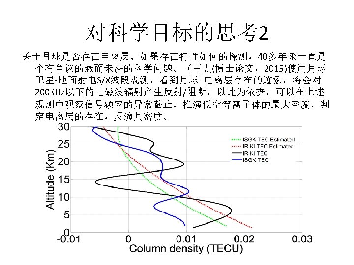
Data Processing for LRR • Followed the idea of LLR technique • Rejecting the low elevation angle (<20°) measurement, • Calculating and removing the atmospheric delay series by using a Saastamoinen-NMF model based on the metereological data. • An IONEX GIM global ionospheric TEC product released by IGS-GNSS of IERS was used to calculated the ionospheric delay between the ground station and lander. • The position of lander was estimated with some fixed parameters, EOP from IERS products, lunar liberation from LE 430/DE 430, solid earth tide model of the ground station from IERS standard. • The estimated coordinates for lander position are read as 19. 50456°W and 44. 1210°N with a fixed radii of 1734. 7680 km at landing area. • The radii value was calculated from LOLA/LRO DEM model.
2 -way LRR result L_up: 1 sps CE-3 LRR in one pass R_up: O-C range and elevation angle R_low: 1 sps range residual -9 mm~27 mm atmospheric disturbulance can be reduced by using micro-wave radiometer or by filting the high frequency signal out
Future works 1: CE-3 lander LRR observations to improve data analysis for (1) EOP, LPh. L, ground site position; (2) combining 2 - & 3 - way data; (3) combining LRR and LLR data
Future works: 2 Frequency remote transfer between Earth and Moon, or between to geo-sites of hundreds and/or thousands KM. 3 Radio Navigation in Earth-Moon or Lunar space
L 2平动点中继卫星 嫦娥-4探测任务测控 月球及月背面着陆器 Chang’E-4 Lunar Farside Lander with a Relay Satellite at L 2 point of Halo Robit ~50 um R&RR量 2程 + 4程 测量 2 -way LRR + 4 -way LRR Atm/Iono E 1 Site 1 up 2 down links E 2 Site 2 downlinks
Future work 4 : 4 -way ranging in CE-4 mission with relay S/C and a farside lander Beyond the lunar and geo dynamic studies, it can be used as pathfinder mission for the techniques in future space gravitational wave exploration. With sensitivity about 1 order better than in CASSINI mission, due to a method of atmospheric disturbulance free method by combining a 2 -way LRR with a 4 -way LRR at same time.
CE-4 lunar Far-side Radio Astronomy: 100 KHz~40 MHz low frequency • • Solar Radio Burst type: II, III Low frequency radio emission from our galaxy Planetary radio burst: Jupiter & … Lunar ionosphere Relay S/C Lander
CE-4 lunar Far-side Radio Astronomy: 100 KHz~40 MHz low frequency Nature Radio@ 1 AU & Moon
RAE-2 occultation of Earth 44
diffractive screening. Radio propagation around the Moon, with subsurface penetration and a lunar density model Takahashi and Woan 45
lunar exosphere • Dual-frequency Luna spacecraft measurements give reasonably good evidence that an ionised layer, several kilometres thick, builds up on the illuminated side of the Moon (Vyshlov 1976) • Max illuminated plasma frequency of ~0. 5 MHz • No layer seen during the lunar night RS-RO for Lunar Ionosphere Luna 22
Solar Burst
Jupiter Radio Emission
Future work (3): Martian Radio Ranging, scince 2016 with INSIGHT mission of NASA ~2 cm ranging accuracy or better
Thank You For Attentions !