HYDROSPHERE Surface Water Surface Water Runoff is excess


 decreases, velocity decreases. • In dry")


- Slides: 25
HYDROSPHERE Surface Water
Surface Water • Runoff is excess water that does not permeate into the land flows over the surface instead. • Runoff may reach a stream, river, or lake, may evaporate or accumulate and eventually seep into the ground.
Factors Affecting Runoff Vegetation – reduces runoff by allowing more water to enter the ground Precipitation – light, gentle rainfall causes less runoff than a torrential downpours. Soil Composition – high runoff if soil consist of silt, clay or shale, low runoff if soil consist of gravel or sand Slope of the land – steep slope = high runoff, shallow slope = low runoff
Surface Water Stream Systems • A stream is a channel with permanent water flow. • Tributaries are streams that flow into other streams, increasing the size of the stream it is joining. • A large stream is called a river, and all its tributaries make up a stream, or river system. • Smaller tributaries are known as creeks and brooks.
Surface Water Rivers Flow of a river or stream is due to GRAVITY. Discharge is the speed at which a river flows (volume rate of water flow; or how much water is passing by). • The following formula is used to calculate the discharge of a stream: discharge = width X depth X velocity (m 3/s) (m) (m/s)
Surface Water Moving Water Carves a Path • Stream banks are the ground bordering the stream on each side • A stream channel forms as the moving water erodes a narrow pathway into rock, creating sediment.
Surface Water Formation of Stream Valleys �As a young stream actively erodes its path through the sediment or rock, a V-shaped channel develops. �As the stream matures, its slope becomes more gentle, forming a U-shaped valley and flood plains in which it begins to slow down and meander. � An old stream has a gentle slope that causes extreme meandering and a wide flood plain with natural leeves �A stream erodes until its base level, the elevation at which it enters another stream or body of water.
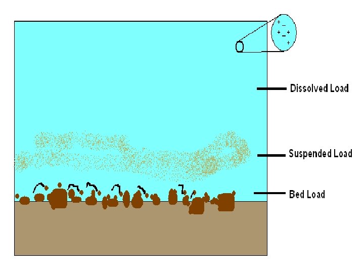
Surface Water Stream Load • A stream carries its load in 3 ways: – Solution – Soluble material which is transported in solution (ions like Ca, K, Cl, SO 4, CO 3) and may end up in the ocean. – Suspension – sediment light enough to stay suspended in turbulent water (silt and clay). – Bed load – sediment particles that travel on the streambed (sand gravel).
Surface Water Meandering Streams • A stream’s slope, or gradient, decreases as it nears its base level. • Sometimes, the water begins to erode the sides of the channel in such a way that the overall path of the stream starts to bend or wind. • A meander is a bend or curve in a stream channel caused by moving water.
Surface Water Meandering Streams – Outside of curve-heavy erosion occurs, water moves fastest. – Inside of curvedeposition occurs, water moves slowest
Surface Water Meandering Streams cont. • It is common for a stream to cut off a meander and once again flow along a straighter path. • The cut off meander becomes an oxbow lake, which eventually dries up. • At the mouth of the stream, the gradient begins to flatten and the channel becomes wide.
Surface Water Deposition of Sediments • Gradient (slope) decreases, velocity decreases. • In dry regions, a stream’s gradient may suddenly decrease causing the stream to drop its sediment at the base of a slope as a fan-shaped deposit called an alluvial fan.
Surface Water Deposition of Sediments cont. • Streams lose velocity when they join larger bodies of quiet water. • A delta is the triangular deposit, usually consisting of silt and clay particles, that forms where a stream enters a large body of water.
Surface Water and Ground Water Groundwater and surface water have a reciprocal relationship, regularly feeding each other. Most streams and rivers get about half their volume from groundwater.
North Carolina’s Estuaries and Wetlands -An estuary is the area in which one or more rivers enter into the ocean, creating brackish water. -A wetland is any area, for at least part of the year, in which the soil is completely saturated or covered with a shallow layer of water. -Area surrounding estuaries is typically going to be wetland.
Reasons to Preserve Estuaries Economic resourcetourism, fisheries Biologically diversedensely populated Center for many species’ reproduction
Reasons to Preserve Wetlands naturally filter pollutants Can withstand excessive amounts of runoff, preventing flooding Plants assist in stabilizing shorelines Provide fish & wildlife habitats
Bog vs Fens have less peat and more Bogs are characterized by their poor soil and high peat plant life than a bog. content.
Swamp vs Marsh Swamps are defined by their ability to support woody plants and trees, Marshes are nutrient-rich wetlands that support a variety of reeds and grasses
Watershed/Drainage Basin A watershed or drainage basin is the land area that contributes water to a stream. A divide is an imaginary line that separates the drainage basins of one stream from another.
NC Drainage Basin Raleigh
Watershed/Drainage Basin
Threats to Our Water Supply *Point Source Pollution: comes from a single, localized source EX: factory
Threats to Our Water Supply *Nonpoint source pollution - pollution from a general area Ex: runoff from farming area