HYDROGEOLOGY Course Objectives Introduction to groundwater including Groundwater

HYDROGEOLOGY

Course Objectives • Introduction to groundwater, including: – Groundwater in the hydrologic cycle – Characteristics of porous media – Darcy's law of flow in porous media – Well hydraulics and aquifer testing – Applications of groundwater hydraulics – Characteristics of unsaturated flow 2
: Hydro = water; Geo")
What is the hydrogeology? Origin of the term (from Greek): Hydro = water; Geo = Earth - ology = science It is the science that deals with the occurrence, movement, and quality of water beneath the Earth's surface. The study of Water properties, distribution, and effects on the Earth’s surface, soil, and atmosphere

Water Management – Sustainable use of water resources – Manipulating the hydrologic cycle Hydraulic structures, water supply, water treatment, wastewater treatment & disposal, irrigation, hydropower generation, flood control, etc.

Some History • Qanats – Subterranean tunnels used to tap and transport groundwater – Originally in Persia – Kilometers in length – Up to 3000 years old – Many still operating Ancient Persian Qanat • Chinese Salt Wells – – – 1000 years ago: Drilled wells Over 300 meters deep Bamboo to retrieve cuttings By year 1858: 1000 meters deep Called “cable tool” drilling today Ancient Chinese Salt Well 5
 � “from whom all rivers are and the entire")
Old Theories �Homer (~1000 BC) � “from whom all rivers are and the entire sea and all springs and all deep wells have their waters” • Vitruvius (~80 -20 BC) – 8 th Book on Water and Aqueducts. Rain and snow on land reappears as springs and rivers �Seneca (3 BC -65 AD) � “You may be quite sure that it not mere rainwater that is carried down into our greatest rivers. ” �Da Vinci (1452 -1519) � accurate representation of the hydrologic cycle • Palissy (1509 -1590). – French scientist and potter - accurate representation of the hydrologic cycle 6
 �Descartes (1596 -1650) � Vapors are drawn up from the")
Old Theories (Cont. ) �Descartes (1596 -1650) � Vapors are drawn up from the earth and condensed… �Kircher (1615 -1680) � Water from the ocean is vaporized by the hot earth, rises, and condenses inside mountains. • Perrault (1670): – Water balance on the Seine. River flow explained by rainfall. • Mariotte (1620 -1684). – French physicist. First recharge estimates. Leaky roof analogy. 7
 – Relationship for the flow through sand filters.")
Modern Theories • Henri Darcy (1856) – Relationship for the flow through sand filters. Resistance of flow through aquifers. Solution for unsteady flow. • King (1899) – Water table maps, groundwater flow, cross-section Henri Darcy • Hazen, Slichter, O. E. Meinzer (1900 s) – Practical applications, basing on theoretical principles of French hydrogeology • C. V. Theis (1930 s) – Well Hydraulics C. V. Theis 8

Definitions Hydrogeology: Emphasizes the hydrologic aspects of geology, e. g. lithologic or facies influences on groundwater movement. Geohydrology: Emphasizing geologic aspects of hydrology, particularly the effects of the porous medium through which groundwater flows. In principle Hydrogeology and Geohydrology have different meanings, in common usage they are identical Hydrosphere: That region of the Earth occupied by water, including lakes, rivers, oceans, subsurface water, glaciers, +/- atmospheric water (clouds, vapor, precipitation)
,")
Surface Water Hydrology: The study of sub aerial waters (in contact with the atmosphere), excluding oceans. Civil engineers usually mean "lakes and bays", geologists usually mean "rivers and streams" when using this term. Ground Water Hydrology: The study of the origin, distribution, movement and physical/chemical properties of ground water. A subset of hydrology, the study of all terrestrial waters.
 2. 5% OF TOTAL GLOBAL (Freshwater) 68. 9%")
Global Water Resources TOTAL GLOBAL (Water) 2. 5% OF TOTAL GLOBAL (Freshwater) 68. 9% Glaciers & Permanent Snow Cover 97. 5% Salt Water 29. 9% Fresh Ground water 0. 3% Freshwater Lakes & River Storage. Only this portion is renewable Groundwater Management in IWRM: Training Manual, GW-MATE, 2010 0. 9% Other including soil moisture, swamp water and permafrost

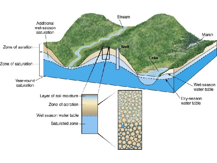
Water cycle • Evaporation from vegetation, land surface and from the ocean forming clouds. • Return the water to the land surface or oceans in the form of precipitation. • The rain wets vegetation and other surfaces then infiltrate into the ground. • Infiltration rates vary widely, depending on land use, the character and moisture content of the soil, and the intensity and duration of precipitation. • When and if the rate of precipitation exceeds the rate of infiltration, overland flow occurs. • The first infiltration replaces soil moisture, and, thereafter, the excess percolates slowly across the intermediate zone to the zone of saturation. • Water in the zone of saturation moves downward and laterally to sites of ground-water discharge such as springs on hillsides or seeps in the bottoms of streams and lakes or beneath the ocean.

Water cycle

• Hydrologic cycle: circulation of water in the environment • Hydrogeology examines the relationships of geologic materials and flowing water

Quantified Hydrologic Cycle

Water Balance much of hydrology is based on determining the water balance for all or some part of the hydrosphere (e. g. a groundwater basin) water balance is just a mass balance: rate of _ mass in rate of mass out = change in content

Basin Hydrologic Cycle – GW/SW Interaction

Soil Texture
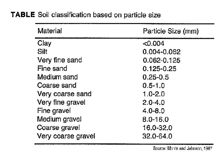

Particle Size Distribution

Porosity and Density

Porosity

Typical Values of Porosity 23

Primary and secondary porosity

Types of Porous Media

REV – Representative Elementary Volume

REV – Scale Effect

Specific yield and specific retention • Specific yield: the part of water that will drain under the influence of gravity. Or How much water is available for man's use? • specific retention the part that is retained as a film on rock surfaces and in very small openings. Or How much water remains in the rock after it is drained by gravity?

Specific yield and specific retention

Underground water • The underground water occurs in two different zones: • Unsaturated zone occurs immediately below the land surface in most areas, contains both water and air. • Saturated zone all interconnected openings are full of water.

Soil Horizons • The soil zone extends from the land surface to depth that supports plant growth. • The intermediate zone extends from the soil zone to the capillary fringe. • The capillary fringe is the lowest part of the unsaturated zone that results from the attraction between water and rocks as the water clings as a film on the surface of rock particles and rises in small-diameter pores against the pull of gravity. • Water in the capillary fringe and in the overlying part of the unsaturated zone is under a negative hydraulic pressure-that is, it is under a pressure less than the atmospheric (barometric) pressure. • The water table is the level in the saturated zone at which the hydraulic pressure is equal to atmospheric pressure and is represented by the water level in unused wells. • Below the water table, the hydraulic pressure increases with increasing depth.
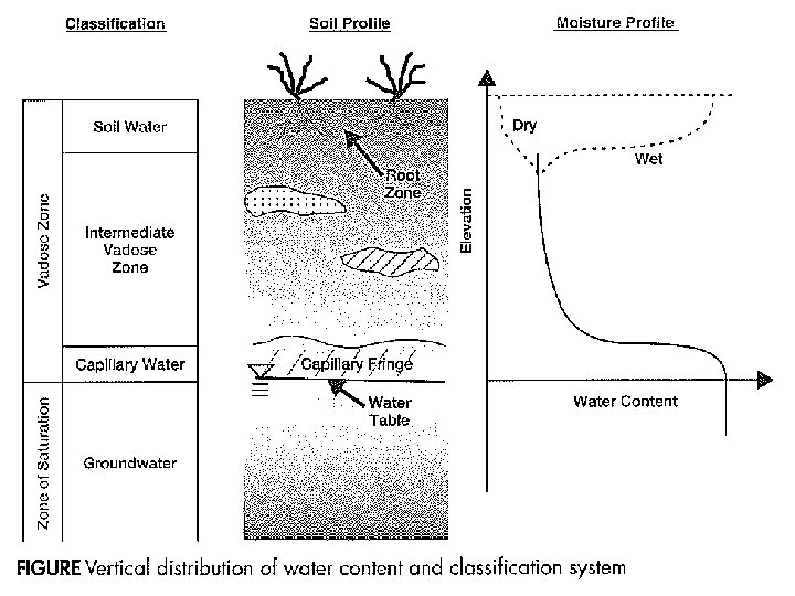

Definitions Water Table • the undulating plane below the ground surface at which pore water pressure is equal to atmospheric • also the dividing line between the unsaturated and saturated zones Phreatic surface: • the level to which water will rise in a well open only within the aquifer, different than the water table only for conned aquifers • when phreatic surface lies at or above the ground surface, an artesian well or spring is possible

Types of water bearing formations • Aquifer - Porous water bearing formations are capable of yielding exploitable quantities of water. • Aquitard - a confining bed that retards but doesn’t prevent the flow of water to or form adjacent aquifer. - Leaky confining bed such as sandy clay - It doesn’t yield water but may serve as a storage unit for groundwater

• Aquiclude - Porous and capable of storing water - Doesn’t transmit sufficient rates of water to wells • - Aquifuge Has no interconnected openings Cannot store or transmit water Unsuitable for groundwater occurrence. Massive granites and quartizite
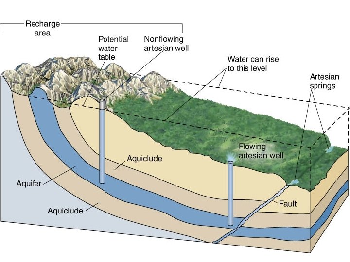

Aquifers Definition: A geological unit which can store and supply significant quantities of water. Principal aquifers by rock type: Unconsolidated Sandstone and Carbonate Semiconsolidated Carbonate-rock Volcanic Other rocks

Example Layered Aquifer System

Types of Aquifers • Free aquifer Ø The water table, is free to rise and decline. Ø The aquifer is referred to as unconfined aquifer or the water-table aquifer. Ø Wells open to unconfined aquifers are referred to as water table wells. • Confined aquifer - Water completely fills the aquifer - It is overlain by a confining bed (impervious bed) - Such aquifers are referred to as confined aquifers or as artesian aquifers. - Wells drilled into confined aquifers are referred to as artesian wells. - The water level in artesian wells stands at some height above the top of the aquifer. - The water level is called the potentiometric level of the aquifer.

Aquifer Features Figure: Important features of groundwater systems, including aquifer/aquitard, water table, etc. After Heath (1978)
: low-permeability bed or unit confined aquifer: an aquifer overlain by a")
confining layer (aquiclude): low-permeability bed or unit confined aquifer: an aquifer overlain by a conning layer unconfined aquifer (phreatic or water table): water table lies below the top of the aquifer semi-confined: an aquifer exhibiting confined and unconfined behavior at different locations (e. g. a sand layer in an alluvial fan) Artesian: can simply mean conned, in common usage it means an aquifer from which water will flow upward to the surface given an appropriate conduit (e. g. a borehole) Perched: a saturated zone lying above unsaturated rock
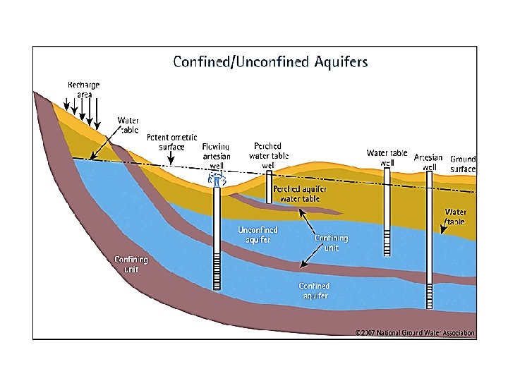

Leaky and Perched Aquifers • Leaky confined aquifer: represents a stratum that allows water to flow from above through a leaky confining zone into the underlying aquifer • Perched aquifer: occurs when an unconfined water zone sits on top of a clay lens, separated from the main aquifer below
- Slides: 44