
Hurricane Executive Oversight Board HFIP Status Review Fred
Hurricane Executive Oversight Board HFIP Status Review Fred Toepfer HFIP Project Manager December 9, 2010 Version 12/07/10
Project Managers Perspective Key Takeaways • HFIP is making significant progress toward meetings it’s 5 year performance goals. – Both track and intensity • Radar data with En. KF appears to be essential for intensity forecasts using high-resolution (<3 km) regional models – Initialization for first 24 hours still a problem • En. KF data assimilation is giving excellent results in the tropics for hurricane track – NCEP is on track to implement operationally – Hybrid Data Assimilation System • The HFIP experimental computer (t-jet) has been central to the efforts toward achieving the HFIP track and intensity goals. – 2003 Solomon’s Island Agreement was instrumental in making this possible • Partnership between operational and research community is growing – will see benefit in an accelerating improvement in HWRF 2
Outline • • • Purpose of Briefing FY 2010 Status FY 2011 Plans Transition to Operations High Performance Computing 3
Briefing Purpose • Review HFIP Status – FY 10 Activities and Accomplishments – FY 11 Plans • Get HEOB agreement on Operational Hurricane Model Development Process • Get HEOB agreement on Scientific Review Committee 4
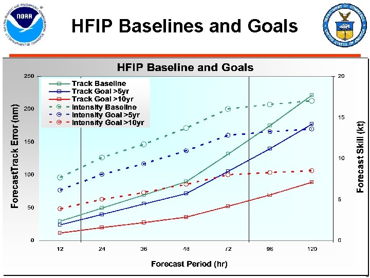
HFIP Baselines and Goals 5
FY 2010 Activities 6
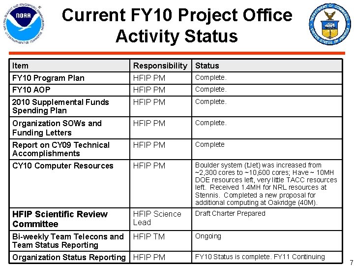
Current FY 10 Project Office Activity Status Item Responsibility Status FY 10 Program Plan HFIP PM Complete. FY 10 AOP HFIP PM Complete. 2010 Supplemental Funds Spending Plan HFIP PM Complete. Organization SOWs and Funding Letters HFIP PM Complete. Report on CY 09 Technical Accomplishments HFIP PM Complete CY 10 Computer Resources HFIP PM Boulder system (t. Jet) was increased from ~2, 300 cores to ~10, 600 cores; Have ~ 10 MH DOE resources left, very little TACC resources left. Received 1. 4 MH for NRL resources at Stennis. Completed a new proposal for additional computing at Oakridge (40 M). HFIP Scientific Review Committee HFIP Science Lead Draft Charter Prepared Bi-weekly Team Telecons and HFIP TM Team Status Reporting Ongoing Organization Status Reporting HFIP PM FY 10 Status is complete. FY 11 Continuing 7
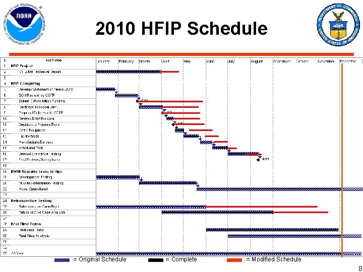
2010 HFIP Schedule = Original Schedule = Complete = Modified Schedule 8
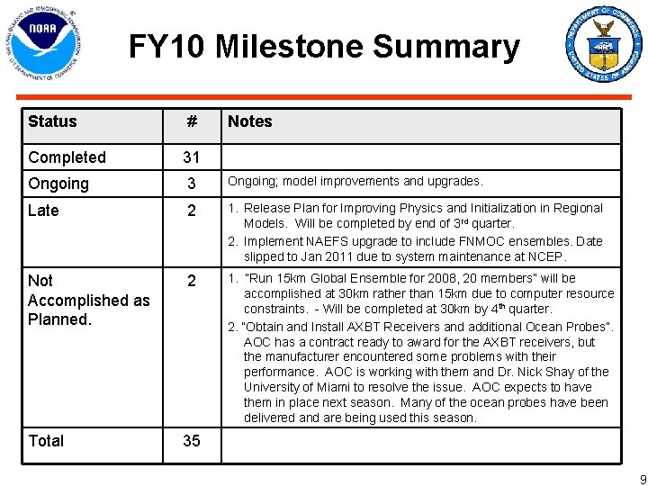
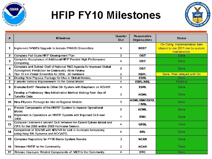
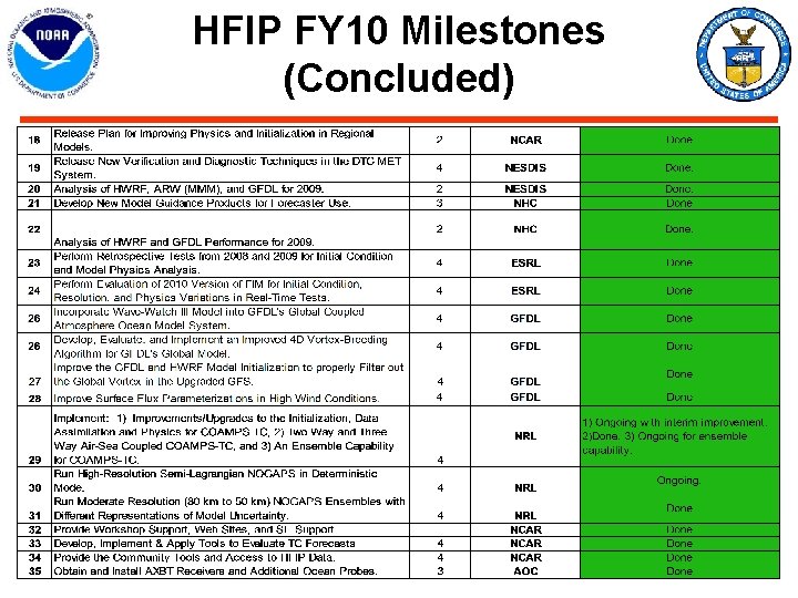
FY 10 Milestone Summary Status # Notes Completed 31 Ongoing 3 Ongoing; model improvements and upgrades. Late 2 1. Release Plan for Improving Physics and Initialization in Regional Models. Will be completed by end of 3 rd quarter. 2. Implement NAEFS upgrade to include FNMOC ensembles. Date slipped to Jan 2011 due to system maintenance at NCEP. Not Accomplished as Planned. 2 1. “Run 15 km Global Ensemble for 2008, 20 members” will be accomplished at 30 km rather than 15 km due to computer resource constraints. - Will be completed at 30 km by 4 th quarter. 2. “Obtain and Install AXBT Receivers and additional Ocean Probes”. AOC has a contract ready to award for the AXBT receivers, but the manufacturer encountered some problems with their performance. AOC is working with them and Dr. Nick Shay of the University of Miami to resolve the issue. AOC expects to have them in place next season. Many of the ocean probes have been delivered and are being used this season. Total 35 9
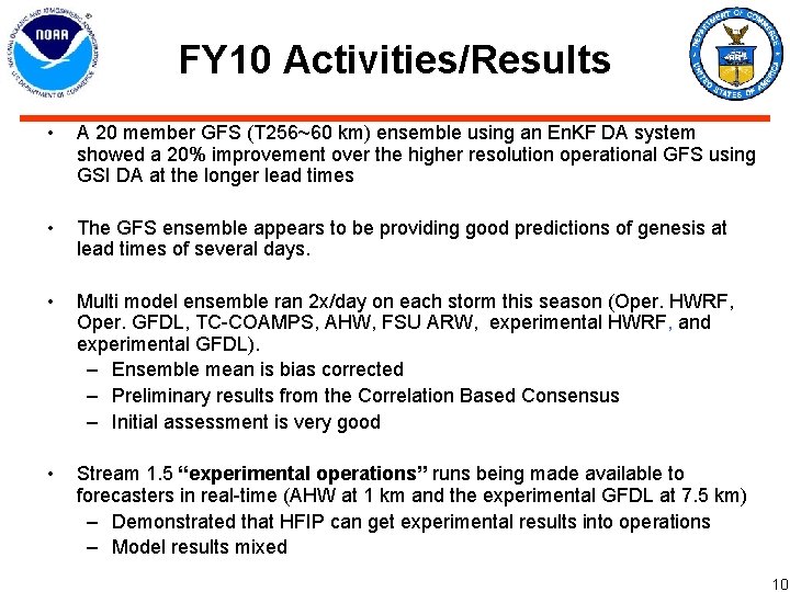
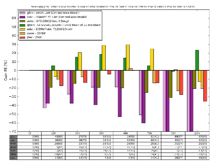
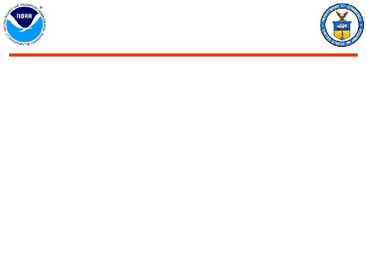
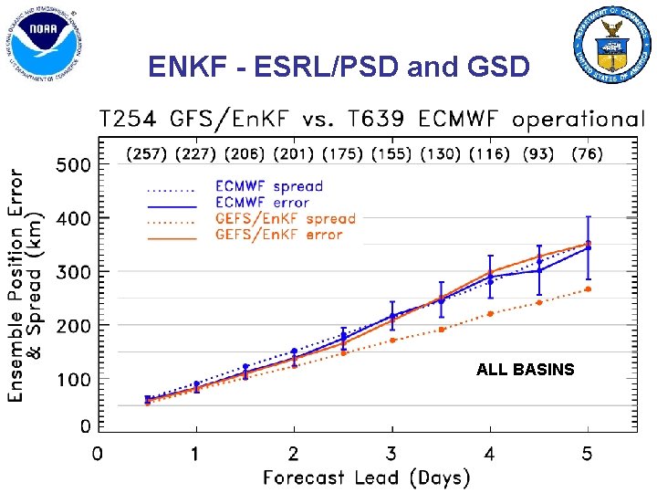
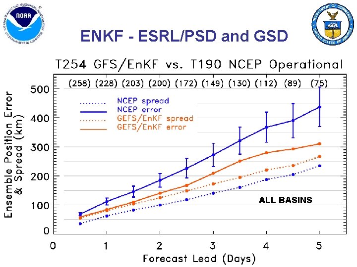
FY 10 Activities/Results • A 20 member GFS (T 256~60 km) ensemble using an En. KF DA system showed a 20% improvement over the higher resolution operational GFS using GSI DA at the longer lead times • The GFS ensemble appears to be providing good predictions of genesis at lead times of several days. • Multi model ensemble ran 2 x/day on each storm this season (Oper. HWRF, Oper. GFDL, TC-COAMPS, AHW, FSU ARW, experimental HWRF, and experimental GFDL). – Ensemble mean is bias corrected – Preliminary results from the Correlation Based Consensus – Initial assessment is very good • Stream 1. 5 “experimental operations” runs being made available to forecasters in real-time (AHW at 1 km and the experimental GFDL at 7. 5 km) – Demonstrated that HFIP can get experimental results into operations – Model results mixed 10
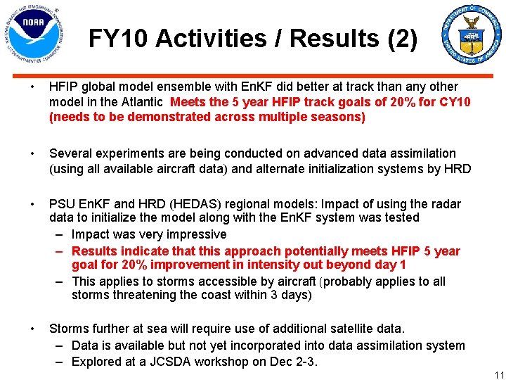
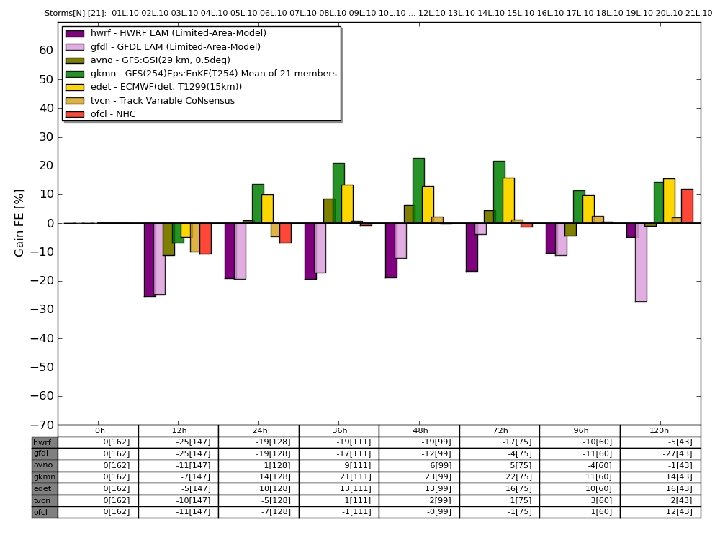
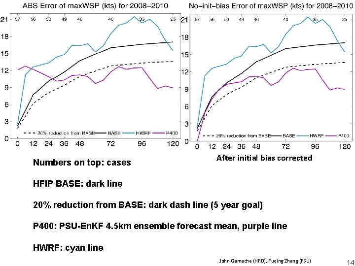
FY 10 Activities / Results (2) • HFIP global model ensemble with En. KF did better at track than any other model in the Atlantic Meets the 5 year HFIP track goals of 20% for CY 10 (needs to be demonstrated across multiple seasons) • Several experiments are being conducted on advanced data assimilation (using all available aircraft data) and alternate initialization systems by HRD • PSU En. KF and HRD (HEDAS) regional models: Impact of using the radar data to initialize the model along with the En. KF system was tested – Impact was very impressive – Results indicate that this approach potentially meets HFIP 5 year goal for 20% improvement in intensity out beyond day 1 – This applies to storms accessible by aircraft (probably applies to all storms threatening the coast within 3 days) • Storms further at sea will require use of additional satellite data. – Data is available but not yet incorporated into data assimilation system – Explored at a JCSDA workshop on Dec 2 -3. 11
12
13
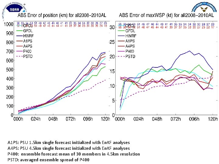
Numbers on top: cases After initial bias corrected HFIP BASE: dark line 20% reduction from BASE: dark dash line (5 year goal) P 400: PSU-En. KF 4. 5 km ensemble forecast mean, purple line HWRF: cyan line John Gamache (HRD), Fuqing Zhang (PSU) 14
Note that error ellipse for the global ensemble is considerably smaller than the current error range 15
Error ellipse similar for all three models 16
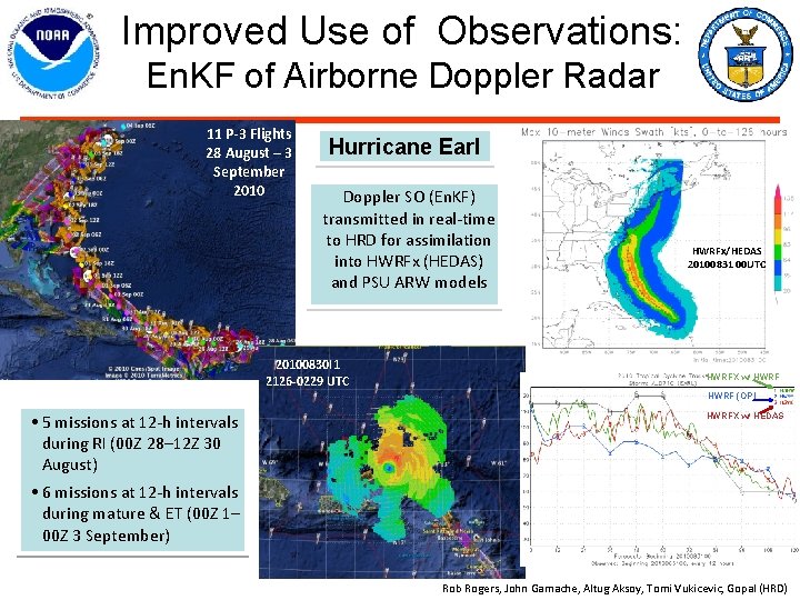
Improved Use of Observations: En. KF of Airborne Doppler Radar 11 P-3 Flights 28 August – 3 September 2010 Hurricane Earl Doppler SO (En. KF) transmitted in real-time to HRD for assimilation into HWRFx (HEDAS) and PSU ARW models HWRFx/HEDAS 20100831 00 UTC 20100830 I 1 2126 -0229 UTC HWRFX w/ HWRF (OP) • 5 missions at 12 -h intervals during RI (00 Z 28– 12 Z 30 August) • 6 missions at 12 -h intervals during mature & ET (00 Z 1– 00 Z 3 September) HWRFX w/ HEDAS HWRFx/HEDAS 20100831 00 UTC Rob Rogers, John Gamache, Altug Aksoy, Tomi Vukicevic, Gopal (HRD)
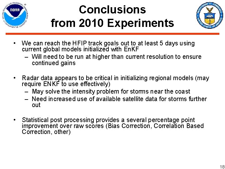
Conclusions from 2010 Experiments • We can reach the HFIP track goals out to at least 5 days using current global models initialized with En. KF – Will need to be run at higher than current resolution to ensure continued gains • Radar data appears to be critical in initializing regional models (may require ENKF to use effectively) – May solve the intensity problem for storms near the coast – Need increased use of available satellite data for storms further out • Statistical post processing provides a several percentage point improvement over raw scores (Bias Correction, Correlation Based Correction, other) 18
FY 10 Funding 19
FY 2011 Plans 20
Strategy to Meet Performance Goals for Global Models • Global models have consistently out-performed regional models on track at all lead times. – Global model ensembles initialized with advanced data assimilation systems (e. g. En. KF) can achieve the track goals – May already have demonstrated the 5 year goals • For intensity global models will only be able to predict environmental controls on intensity. – Resolution prevents accounting for the impact of internal (near the eyewall) processes – Statistical processing (eg: bias correction may allow a three category intensity forecast with the global models: • Tropical storm • Hurricane • Major hurricane 21
Strategy to Meet Performance Goals for Regional Models • Regional models are the best hope to achieve accurate forecasts of intensity changes forced by processes internal to the hurricane – Eyewall replacement cycles – Fine scale interaction with the ocean – Convective processes • These require high resolution ~ 1 -3 km • Major issues with the regional models are initialization and physics. – Use of aircraft data may solve the initialization problem for some storms (particularly storms threatening the coast within 3 days) – HFIP may have demonstrated its 5 year intensity goals for storms nearing landfall 22
FY 11 HFIP Events • HFIP Annual Review Meeting in Miami: November 9 -10, 2010 • JCSDA/HFIP Workshop on use of satellite data for hurricane model initialization: December 2 -3, 2010 • HFIP Status Meetings (TBD): Monterey, Miami, and Boulder • Fund 3 rd year of NOPP agreement • AMS Annual Conference in Seattle: Jan 23 -27, 2011 • HFIP Request for Proposal in January 2011 – HFIP support ~ $500 K-$1 M; 7 -10 projects @ 50 K-150 K/project – Critical to harness talent within external community • 2 nd Joint Hurricane Workshop & Tutorial: April 2011 – AHW and HWRF code in WRF repository – Support community regional hurricane modeling R&D and R 2 O 23
HFIP Science Priorities • Advancement in DA techniques for hurricane NWP • Physics Advancements – Microphysical processes – Air-sea processes and BL processes • R&D for determining optimal resolution and complexity of coupling • Advanced model diagnostic techniques – Analyses and forecast of large-scale and hurricane environment evolution – Identification and analyses of sources of model errors • Development of high resolution ensembles – Identify resolution and optimality of the number of ensemble members – Improve intensity guidance • Techniques to maximize the usefulness of observations 24
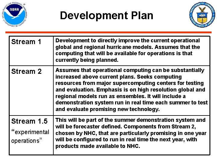
Development Plan Stream 1 Development to directly improve the current operational global and regional hurricane models. Assumes that the computing that will be available for operations is that currently being planned. Stream 2 Assumes that operational computing can be substantially increased above current plans. Seeks computing resources from major supercomputing centers for testing and evaluation. Emphasis is on high resolution global and regional models run as ensembles. It will include a demonstration system run in real time each summer to test and evaluate promising new technology. Stream 1. 5 This will be part of the summer demonstration system and will be forecaster defined. Components from Stream 2, “experimental chosen by NHC, that are particularly promising in one year will be configured to run in real time the next year, with operations” products made available to NHC.
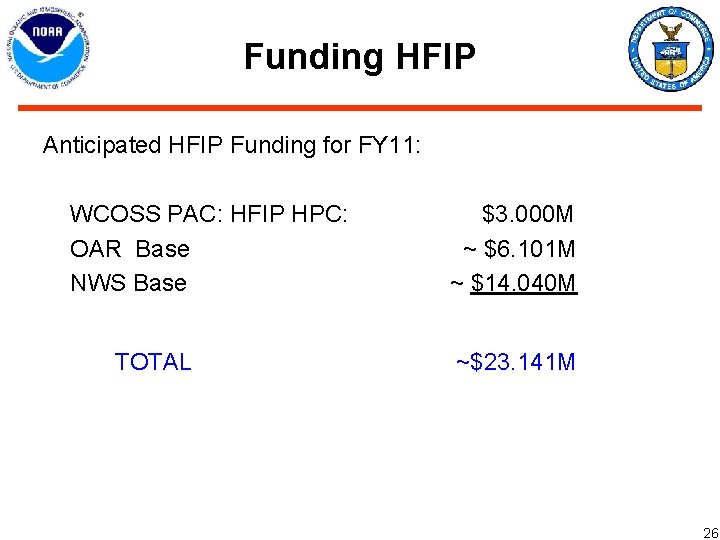
Funding HFIP Anticipated HFIP Funding for FY 11: WCOSS PAC: HFIP HPC: OAR Base NWS Base TOTAL $3. 000 M ~ $6. 101 M ~ $14. 040 M ~$23. 141 M 26
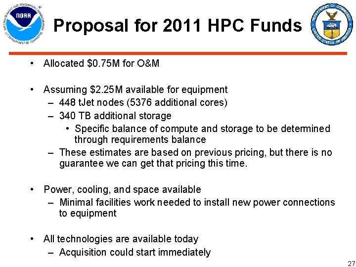
Proposal for 2011 HPC Funds • Allocated $0. 75 M for O&M • Assuming $2. 25 M available for equipment – 448 t. Jet nodes (5376 additional cores) – 340 TB additional storage • Specific balance of compute and storage to be determined through requirements balance – These estimates are based on previous pricing, but there is no guarantee we can get that pricing this time. • Power, cooling, and space available – Minimal facilities work needed to install new power connections to equipment • All technologies are available today – Acquisition could start immediately 27
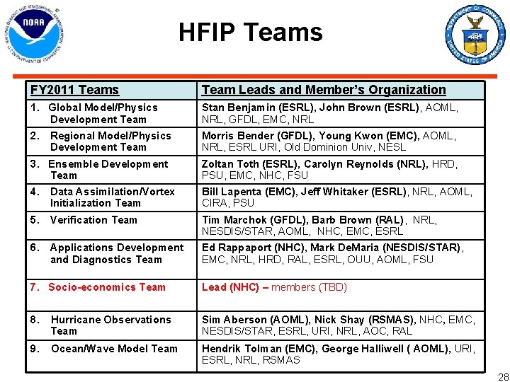
HFIP Teams FY 2011 Teams Team Leads and Member’s Organization 1. Global Model/Physics Development Team Stan Benjamin (ESRL), John Brown (ESRL), AOML, NRL, GFDL, EMC, NRL 2. Morris Bender (GFDL), Young Kwon (EMC), AOML, NRL, ESRL URI, Old Dominion Univ, NESL Regional Model/Physics Development Team 3. Ensemble Development Team Zoltan Toth (ESRL), Carolyn Reynolds (NRL), HRD, PSU, EMC, NHC, FSU 4. Bill Lapenta (EMC), Jeff Whitaker (ESRL), NRL, AOML, CIRA, PSU Data Assimilation/Vortex Initialization Team 5. Verification Team Tim Marchok (GFDL), Barb Brown (RAL), NRL, NESDIS/STAR, AOML, NHC, EMC, ESRL 6. Ed Rappaport (NHC), Mark De. Maria (NESDIS/STAR), EMC, NRL, HRD, RAL, ESRL, OUU, AOML, FSU Applications Development and Diagnostics Team 7. Socio-economics Team Lead (NHC) – members (TBD) 8. Hurricane Observations Team Sim Aberson (AOML), Nick Shay (RSMAS), NHC, EMC, NESDIS/STAR, ESRL, URI, NRL, AOC, RAL 9. Ocean/Wave Model Team Hendrik Tolman (EMC), George Halliwell ( AOML), URI, ESRL, NRL, RSMAS 28
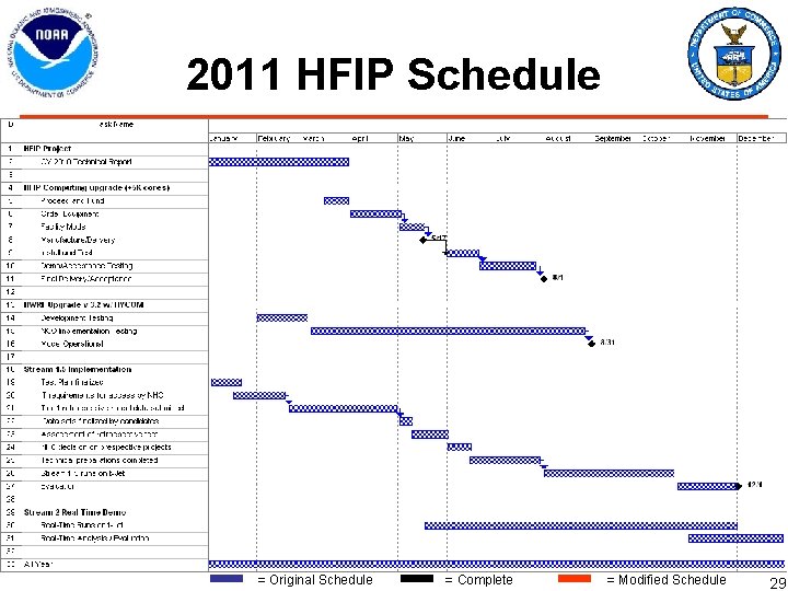
2011 HFIP Schedule = Original Schedule = Complete = Modified Schedule 29
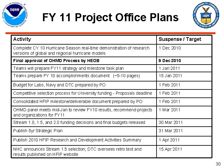
FY 11 Project Office Plans Activity Suspense / Target Complete CY 10 Hurricane Season real-time demonstration of research versions of global and regional hurricane models 1 Dec 2010 Final approval of OHMD Process by HEOB 9 Dec 2010 Teams will prepare FY 11 strategy and milestone task plan 1 Jan 2011 Teams prepare FY 10 accomplishments document (~5 -10 pages) 15 Jan 2011 Budget for Labs, Navy and DTC prepared by PO 1 Feb 2011 Competitive selection process for University funding - Proposals deadline 1 Feb 2011 Consolidated HFIP milestone/deliverable document prepared by PO 1 Feb 2011 OHMD panel meets mid-Jan to review FY 10 results, recommend projects and organizations for FY 11 1 Mar 2011 Stream 1. 0, 1. 5, and 2. 0 funding decisions and final budgets released 30 Mar 2011 Publish 5 yr Strategic Plan 31 Mar 2011 Publish 2010 HFIP Research and Development Activities Summary 1 Apr 2011 NHC announces Stream 1. 5 selection; DTC oversees retro test and results published on HFIP website 15 Apr 2011 30
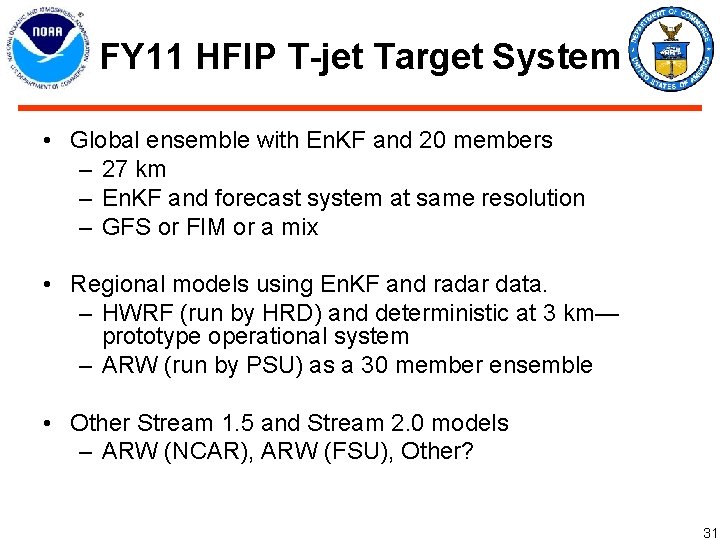
FY 11 HFIP T-jet Target System • Global ensemble with En. KF and 20 members – 27 km – En. KF and forecast system at same resolution – GFS or FIM or a mix • Regional models using En. KF and radar data. – HWRF (run by HRD) and deterministic at 3 km— prototype operational system – ARW (run by PSU) as a 30 member ensemble • Other Stream 1. 5 and Stream 2. 0 models – ARW (NCAR), ARW (FSU), Other? 31
T-Jet Allocation for Real Time Runs 32
FY 11 AOP Preliminary 33
FY 11 AOP Preliminary (2) 34
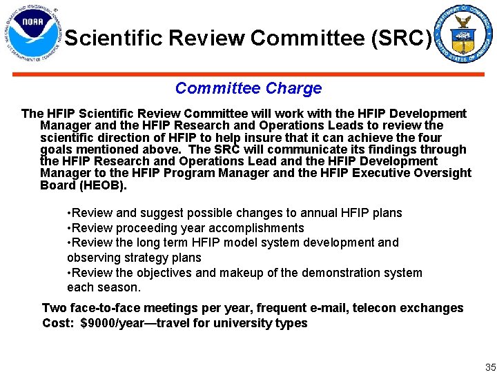
Scientific Review Committee (SRC) Committee Charge The HFIP Scientific Review Committee will work with the HFIP Development Manager and the HFIP Research and Operations Leads to review the scientific direction of HFIP to help insure that it can achieve the four goals mentioned above. The SRC will communicate its findings through the HFIP Research and Operations Lead and the HFIP Development Manager to the HFIP Program Manager and the HFIP Executive Oversight Board (HEOB). • Review and suggest possible changes to annual HFIP plans • Review proceeding year accomplishments • Review the long term HFIP model system development and observing strategy plans • Review the objectives and makeup of the demonstration system each season. Two face-to-face meetings per year, frequent e-mail, telecon exchanges Cost: $9000/year—travel for university types 35
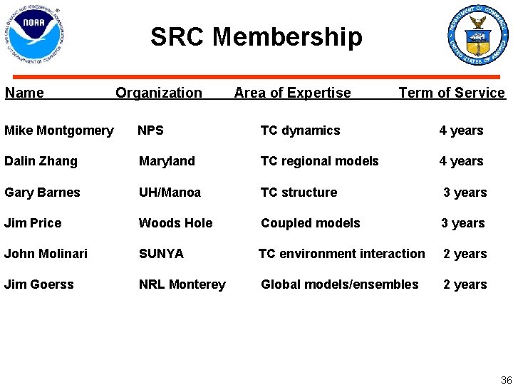
SRC Membership Name Organization Area of Expertise Term of Service Mike Montgomery NPS TC dynamics 4 years Dalin Zhang Maryland TC regional models 4 years Gary Barnes UH/Manoa TC structure 3 years Jim Price Woods Hole Coupled models 3 years John Molinari SUNYA Jim Goerss NRL Monterey TC environment interaction 2 years Global models/ensembles 2 years 36
Transition to Operations 37
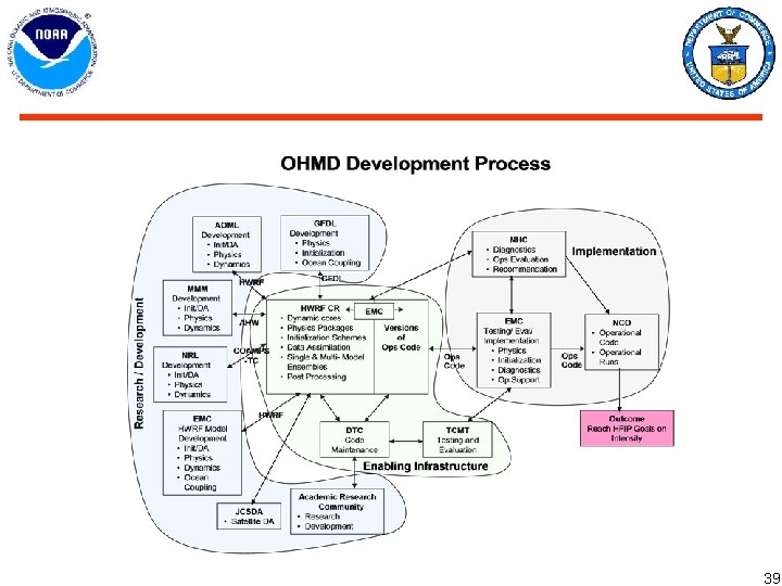
Stream 1. 0 Management (HWRF) • Reasons to change HWRF Management – We want more emphasis on improving the operational model. – We want the operational model development to be managed by a committee made up of members of the organizations contributing directly to the development • • • Management Structure will be referred to as – Operational Hurricane Regional Model Development/Implementation (OHMD) Changes will apply only to Stream 1. Stream 2. 0 will be managed by the teams and Stream 1. 5 by NHC/DTC/TCMT Committee will consist of members from: – EMC, AOML, GFDL, DTC, NRL, NHC, NCAR/MMM, JCSDA, plus 2 university representatives – EMC and AOML have established a strong partnership in HWRF development – Committee is responsible for setting priorities and monitoring the development process and progress • • A Central Repository similar to WRF will be maintained by the DTC – Both research and operational codes will be drawn from the repository Final configuration of the operational system will remain unchanged but will use extensive input from the OHMD process Focus development on T 2 O through HWRF Repository at DTC 38
39
Hybrid Data Assimilation and Ensemble Forecast System (HEVDAS) Current Status • • • GSI code upgraded for hybrid – all coding complete Executes at operational resolution (27 km) En. KF upgrade planned Q 4 FY 11 Preliminary runs in progress Next Steps • Improved NCEP global system (data assimilation and ensemble systems) – Ensemble forecast (1 -15 days) generation • Use HEVDAS perturbations as starting point for ensemble forecast • Optimize perturbations for ensemble (1 -15 day) forecast – Improve turnaround on NOAA T-jet • Dedicated resources for continuous runs • Hybrid • High res (T 574) forecast • Ensemble (T 254) forecast – Resource assessment for operational implementation • Generate hybrid data assimilation ensemble from “GDAS” cycle Implementation possible no earlier than spring 2012 May need to wait until procurement of new system (2014) 40
Target Operational Prediction System for 2014 • 20 -40 member ensembles: 15 km global and 3 km regional resolution – two global model cores/physics (FIM? , NMM? ) – three regional model cores/physics (HWRF, AHW, COAMPS-TC? ) • • Statistical post processing of both track and intensity from a 20 year reforecast from the various models. Rerun each year At least one member of each model in the ensembles will be computed using a full 3 D ocean. Others may used parameterized ocean coupling Both global and regional models will use a 4 DVAR/Ensemble hybrid system Regional models will use all available satellite and aircraft derived data for inner core initialization – Ensemble and model products that maximize value to forecasters will be emphasized 41
HFIP Computing 42
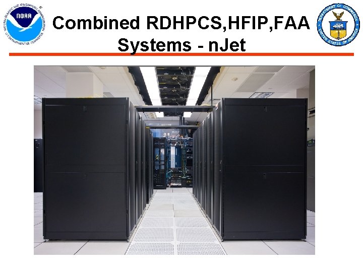
HFIP System - t. Jet 43
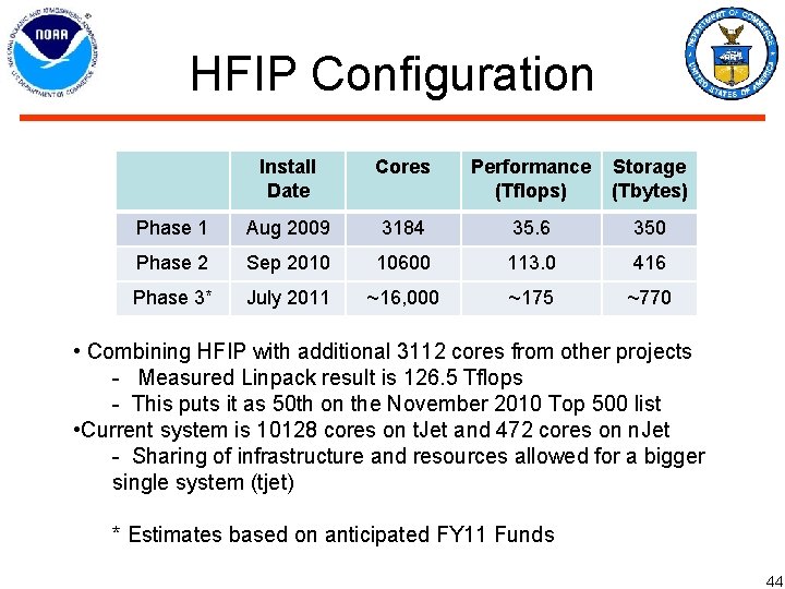
HFIP Configuration Install Date Cores Performance (Tflops) Storage (Tbytes) Phase 1 Aug 2009 3184 35. 6 350 Phase 2 Sep 2010 10600 113. 0 416 Phase 3* July 2011 ~16, 000 ~175 ~770 • Combining HFIP with additional 3112 cores from other projects - Measured Linpack result is 126. 5 Tflops - This puts it as 50 th on the November 2010 Top 500 list • Current system is 10128 cores on t. Jet and 472 cores on n. Jet - Sharing of infrastructure and resources allowed for a bigger single system (tjet) * Estimates based on anticipated FY 11 Funds 44
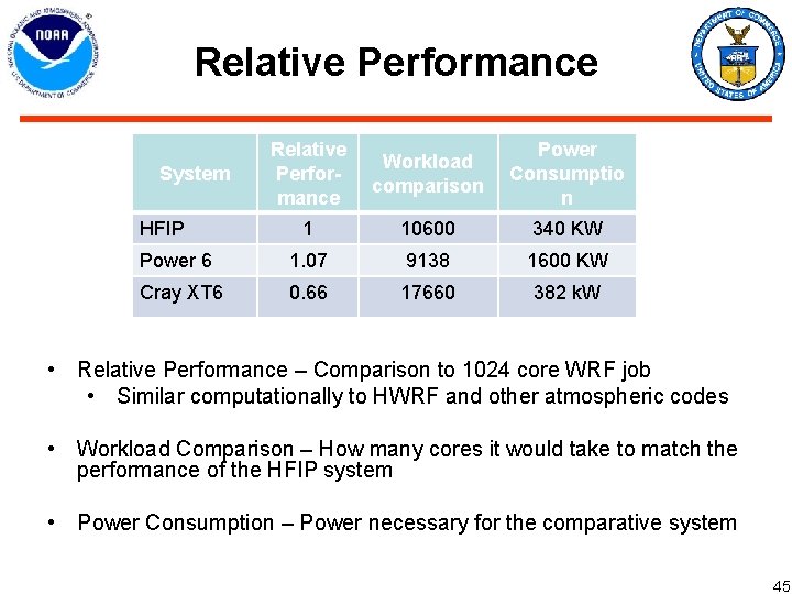
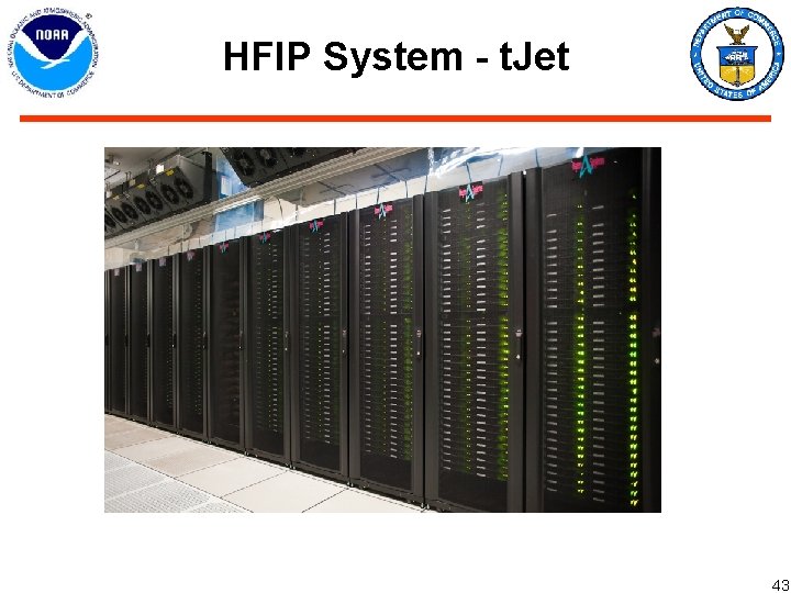
Relative Performance Workload comparison Power Consumptio n 1 10600 340 KW Power 6 1. 07 9138 1600 KW Cray XT 6 0. 66 17660 382 k. W System HFIP • Relative Performance – Comparison to 1024 core WRF job • Similar computationally to HWRF and other atmospheric codes • Workload Comparison – How many cores it would take to match the performance of the HFIP system • Power Consumption – Power necessary for the comparative system 45
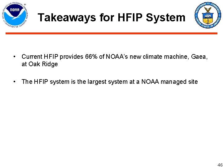
Takeaways for HFIP System • Current HFIP provides 66% of NOAA’s new climate machine, Gaea, at Oak Ridge • The HFIP system is the largest system at a NOAA managed site 46
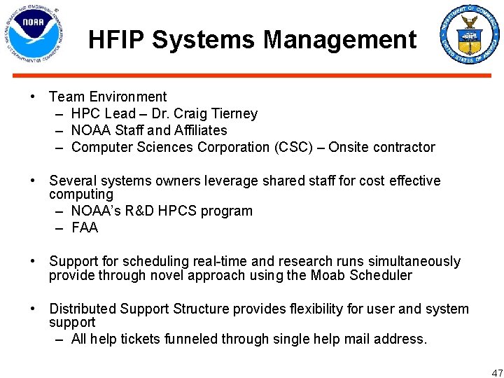
HFIP Systems Management • Team Environment – HPC Lead – Dr. Craig Tierney – NOAA Staff and Affiliates – Computer Sciences Corporation (CSC) – Onsite contractor • Several systems owners leverage shared staff for cost effective computing – NOAA’s R&D HPCS program – FAA • Support for scheduling real-time and research runs simultaneously provide through novel approach using the Moab Scheduler • Distributed Support Structure provides flexibility for user and system support – All help tickets funneled through single help mail address. 47
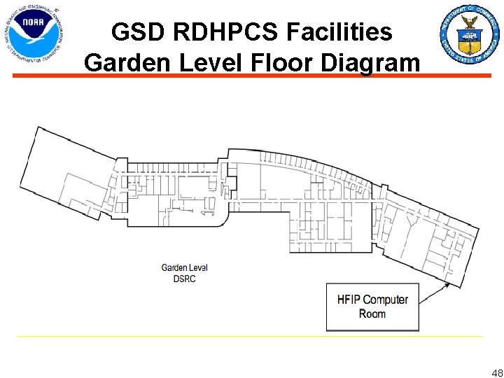
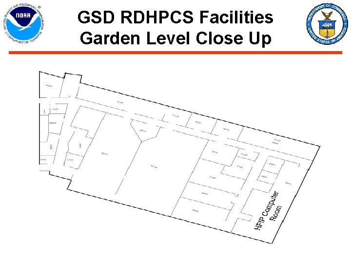
GSD RDHPCS Facilities Garden Level Floor Diagram 48
Backup Slides 49
HFIP FY 10 Milestones
HFIP FY 10 Milestones (Concluded)
FY 10 Funding Distribution
5 yr Targets for Global Models
5 yr Targets for Regional Models

n. Jet and t. Jet Systems
Combined RDHPCS, HFIP, FAA Systems - n. Jet
GSD RDHPCS Facilities Garden Level Close Up
En. KF Based Global Ensemble • HFIP global model ensemble with En. KF did better at track than any other model in the Atlantic – Meets the 5 year HFIP track goals of 20% • Similar performance in the WPAC but ECMWF generally did better. – ECMWF has better statistical scores aver-all for the mid-latitudes than the HFIP global ensemble and visa versa in the tropics. – Mid latitude influences in the WPAC may account for the better performance of the ECMWF there • Probably due to much higher resolution of ECMWF We need to increase resolution of HFIP global ensemble to maintain the 2010 performance in the Atlantic
ENKF - ESRL/PSD and GSD ALL BASINS
ENKF - ESRL/PSD and GSD ALL BASINS
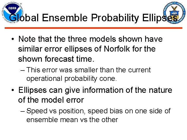
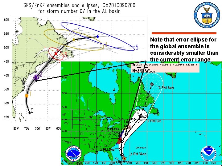
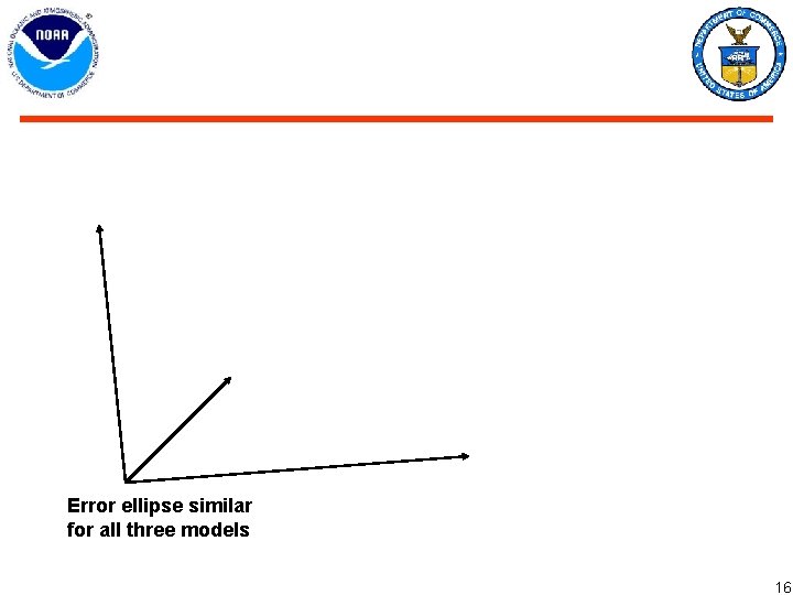
Global Ensemble Probability Ellipses • Note that the three models shown have similar error ellipses of Norfolk for the shown forecast time. – This error was smaller than the current operational probability cone. • Ellipses can give information of the nature of the model error – Speed vs position, speed bias on one side of ensemble mean vs the other
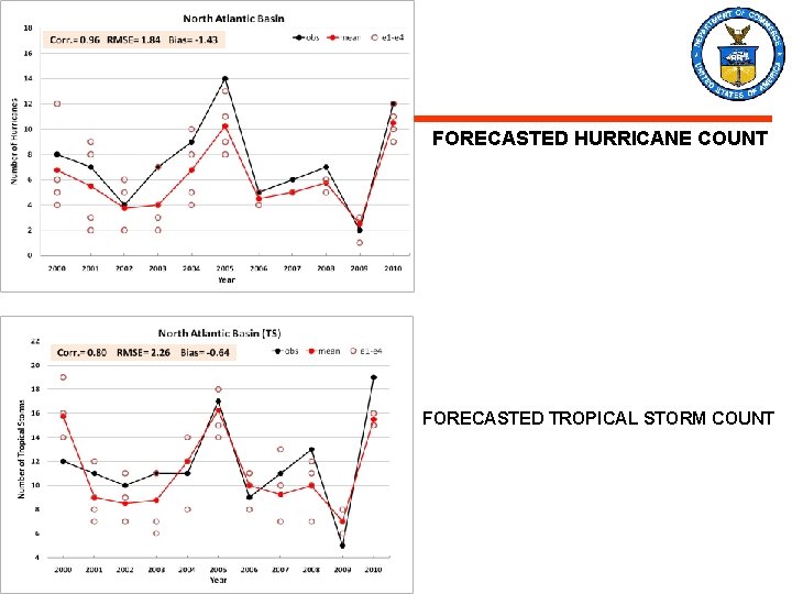
FORECASTED HURRICANE COUNT FORECASTED TROPICAL STORM COUNT
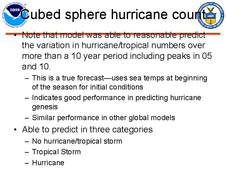
Cubed sphere hurricane count • Note that model was able to reasonable predict the variation in hurricane/tropical numbers over more than a 10 year period including peaks in 05 and 10. – This is a true forecast—uses sea temps at beginning of the season for initial conditions – Indicates good performance in predicting hurricane genesis – Similar performance in other global models • Able to predict in three categories – No hurricane/tropical storm – Tropical Storm – Hurricane
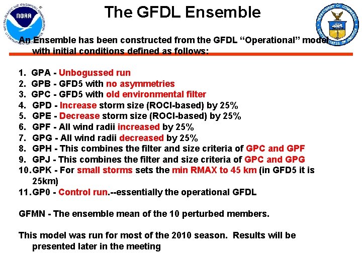
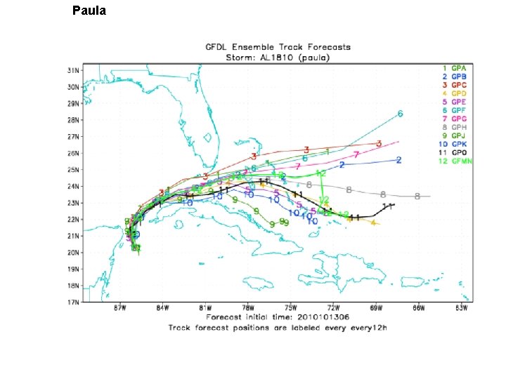
The GFDL Ensemble An Ensemble has been constructed from the GFDL “Operational” model with initial conditions defined as follows: 1. GPA - Unbogussed run 2. GPB - GFD 5 with no asymmetries 3. GPC - GFD 5 with old environmental filter 4. GPD - Increase storm size (ROCI-based) by 25% 5. GPE - Decrease storm size (ROCI-based) by 25% 6. GPF - All wind radii increased by 25% 7. GPG - All wind radii decreased by 25% 8. GPH - This combines the filter and size criteria of GPC and GPF 9. GPJ - This combines the filter and size criteria of GPC and GPG 10. GPK - For small storms sets the min RMAX to 45 km (in GFD 5 it is 25 km) 11. GP 0 - Control run. --essentially the operational GFDL GFMN - The ensemble mean of the 10 perturbed members. This model was run for most of the 2010 season. Results will be presented later in the meeting
Paula
GFDL Ensemble • The operational GFDL model was run as an ensemble for second half of the season – Demonstrate the track spread associated with a given model as it is perturbed – Allow NHC to see the impact of some modest changes in the model—ensemble was selected with forecaster input.
PSU ARW-En. KF Assimilating Airborne Radar OBS Mean Absolute Error and Ensemble Spread for all 56 cases from 2008 A 1 PS: PSU 1. 5 km single forecast initialized with En. KF analyses A 4 PS: PSU 4. 5 km single forecast initialized with En. KF analyses P 400: ensemble forecast mean of 30 members in 4. 5 km resolution PSTD: averaged ensemble spread of P 400
PSU En. KF regional model: Initialized with aircraft radar data • Impact of using the radar data to initialize the model along with the En. KF system was tested – Impact was very impressive – Results indicate that this approach meets HFIP 5 year goal for 20% improvement in intensity out to 3 -4 days • This applies to storms accessible by aircraf – Probably applies to all storms threatening the coast within 3 days. • Storms further at sea will require use of additional satellite data. – This data is available but needs to be incorporated into data assimilation system – Explored at a JCSDA workshop on Dec 2 -3.
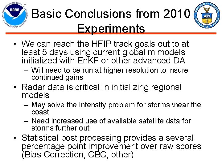
Basic Conclusions from 2010 Experiments • We can reach the HFIP track goals out to at least 5 days using current global m models initialized with En. KF or other advanced DA – Will need to be run at higher resolution to insure continued gains • Radar data is critical in initializing regional models – May solve the intensity problem for storms near the coast – Need increased use of available satellite data for storms further out • Statistical post processing provides a several percentage point improvement over raw scores (Bias Correction, CBC, other)
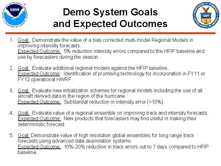
Demo System Goals and Expected Outcomes 1. Goal: Demonstrate the value of a bias corrected multi-model Regional Models in improving intensity forecasts. Expected Outcome: 5% reduction intensity errors compared to the HFIP baseline and use by forecasters during the season. . 2. Goal: Evaluate additional regional models against the HFIP baseline. Expected Outcome: Identification of promising technology for incorporation in FY 11 or FY 12 operational HWRF. 3. Goal: Evaluate new initialization schemes for regional models including the use of all aircraft derived data in the region of the hurricane. Expected Outcome: Substantial reduction in intensity error (>10%). 4. Goal: Evaluate value of a regional ensemble on improving track and intensity forecasts. Expected Outcome: New products that forecasters may find useful in making their deterministic forecast. 5. Goal: Demonstrate value of high resolution global ensembles for long range track forecasts using advanced data assimilation systems. Expected Outcome: 10%-20% reduction in track errors out to 7 days compared to HFIP baseline.
Computing Resources Available for HFIP
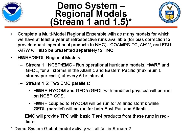
Demo System – Regional Models (Stream 1 and 1. 5)* • Complete a Multi-Model Regional Ensemble with as many models for which we have at least a year of retrospective runs available (for bias correction to provide quasi- operational products to NHC). COAMPS-TC, AHW, and FSU -ARW will also be presented separately to HNC. • HWRF/GFDL Regional Models: – Stream 1: NCEP/EMC - Run operational hurricane models, HWRF and GFDL, for all storms in the Atlantic and Eastern Pacific (maximum 5 storms per cycle) at every 6 -hr interval. – Stream 1. 5: Two EMC parallels: • HWRF-HYCOM and GFD 5 (GFDL with modified physics) will be run on NCEP CCS. • HWRF coupled to HYCOM will be run for Atlantic storms while GFDL (parallel) will be run for both East Pac and Atlantic. EMC will provide TPC with basic Tier-I products from these runs in realtime. * Demo System Global model activity will all fall in Stream 2
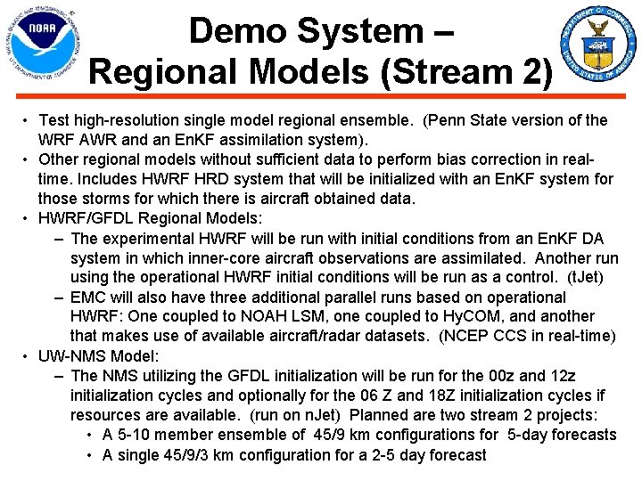
Demo System – Regional Models (Stream 2) • Test high-resolution single model regional ensemble. (Penn State version of the WRF AWR and an En. KF assimilation system). • Other regional models without sufficient data to perform bias correction in realtime. Includes HWRF HRD system that will be initialized with an En. KF system for those storms for which there is aircraft obtained data. • HWRF/GFDL Regional Models: – The experimental HWRF will be run with initial conditions from an En. KF DA system in which inner-core aircraft observations are assimilated. Another run using the operational HWRF initial conditions will be run as a control. (t. Jet) – EMC will also have three additional parallel runs based on operational HWRF: One coupled to NOAH LSM, one coupled to Hy. COM, and another that makes use of available aircraft/radar datasets. (NCEP CCS in real-time) • UW-NMS Model: – The NMS utilizing the GFDL initialization will be run for the 00 z and 12 z initialization cycles and optionally for the 06 Z and 18 Z initialization cycles if resources are available. (run on n. Jet) Planned are two stream 2 projects: • A 5 -10 member ensemble of 45/9 km configurations for 5 -day forecasts • A single 45/9/3 km configuration for a 2 -5 day forecast
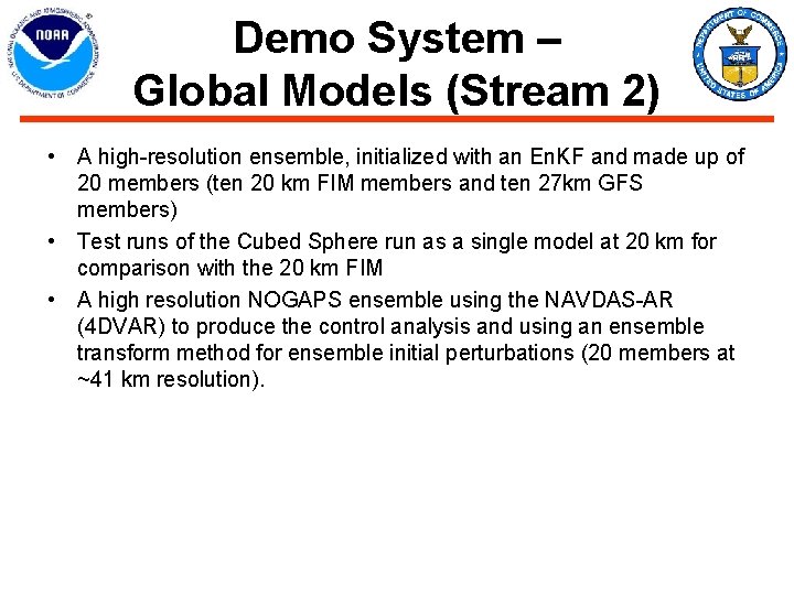
Demo System – Global Models (Stream 2) • A high-resolution ensemble, initialized with an En. KF and made up of 20 members (ten 20 km FIM members and ten 27 km GFS members) • Test runs of the Cubed Sphere run as a single model at 20 km for comparison with the 20 km FIM • A high resolution NOGAPS ensemble using the NAVDAS-AR (4 DVAR) to produce the control analysis and using an ensemble transform method for ensemble initial perturbations (20 members at ~41 km resolution).
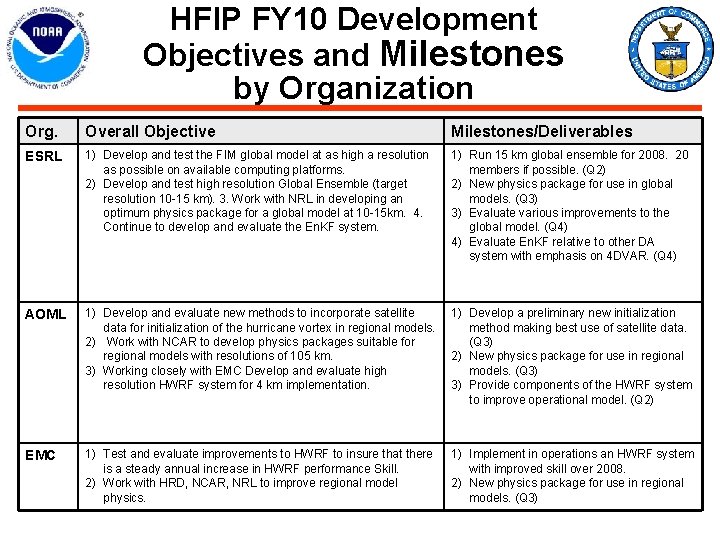
HFIP FY 10 Development Objectives and Milestones by Organization Org. Overall Objective Milestones/Deliverables ESRL 1) Develop and test the FIM global model at as high a resolution as possible on available computing platforms. 2) Develop and test high resolution Global Ensemble (target resolution 10 -15 km). 3. Work with NRL in developing an optimum physics package for a global model at 10 -15 km. 4. Continue to develop and evaluate the En. KF system. 1) Run 15 km global ensemble for 2008. 20 members if possible. (Q 2) 2) New physics package for use in global models. (Q 3) 3) Evaluate various improvements to the global model. (Q 4) 4) Evaluate En. KF relative to other DA system with emphasis on 4 DVAR. (Q 4) AOML 1) Develop and evaluate new methods to incorporate satellite 1) Develop a preliminary new initialization data for initialization of the hurricane vortex in regional models. method making best use of satellite data. 2) Work with NCAR to develop physics packages suitable for (Q 3) regional models with resolutions of 105 km. 2) New physics package for use in regional 3) Working closely with EMC Develop and evaluate high models. (Q 3) resolution HWRF system for 4 km implementation. 3) Provide components of the HWRF system to improve operational model. (Q 2) EMC 1) Test and evaluate improvements to HWRF to insure that there is a steady annual increase in HWRF performance Skill. 2) Work with HRD, NCAR, NRL to improve regional model physics. 1) Implement in operations an HWRF system with improved skill over 2008. 2) New physics package for use in regional models. (Q 3)
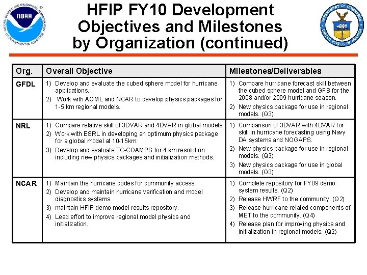
HFIP FY 10 Development Objectives and Milestones by Organization (continued) Org. Overall Objective Milestones/Deliverables GFDL 1) Develop and evaluate the cubed sphere model for hurricane 1) Compare hurricane forecast skill between applications. the cubed sphere model and GFS for the 2008 and/or 2009 hurricane season. 2) Work with AOML and NCAR to develop physics packages for 1 -5 km regional models. 2) New physics package for use in regional models. (Q 3) NRL 1) Compare relative skill of 3 DVAR and 4 DVAR in global models. 1) 2) Work with ESRL in developing an optimum physics package for a global model at 10 -15 km. 2) 3) Develop and evaluate TC-COAMPS for 4 km resolution including new physics packages and initialization methods. 3) NCAR 1) Maintain the hurricane codes for community access. 2) Develop and maintain hurricane verification and model diagnostics systems. 3) maintain HFIP demo model results repository. 4) Lead effort to improve regional model physics and initialization. Comparison of 3 DVAR with 4 DVAR for skill in hurricane forecasting using Navy DA systems and NOGAPS. New physics package for use in regional models. (Q 3) New physics package for use in global models. (Q 3) 1) Complete repository for FY 09 demo system results. (Q 2) 2) Release HWRF to the community. (Q 2) 3) Release hurricane related components of MET to the community. (Q 4) 4) Release plan for improving physics and initialization in regional models. (Q 2)
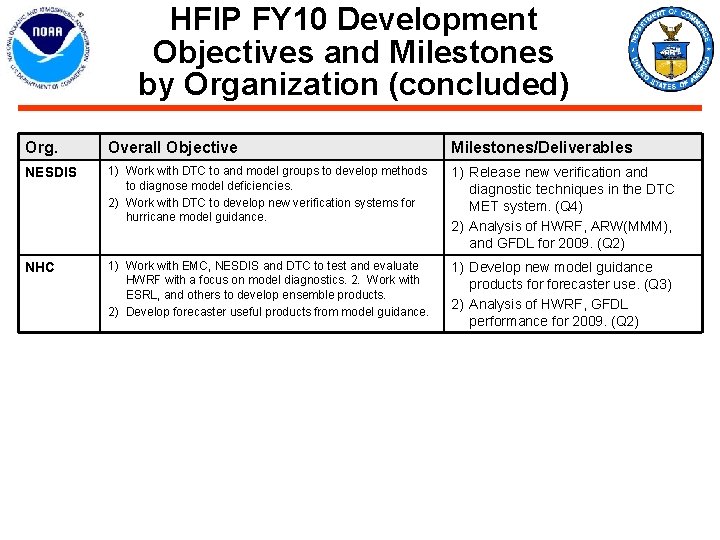
HFIP FY 10 Development Objectives and Milestones by Organization (concluded) Org. Overall Objective Milestones/Deliverables NESDIS 1) Work with DTC to and model groups to develop methods to diagnose model deficiencies. 2) Work with DTC to develop new verification systems for hurricane model guidance. 1) Release new verification and diagnostic techniques in the DTC MET system. (Q 4) 2) Analysis of HWRF, ARW(MMM), and GFDL for 2009. (Q 2) NHC 1) Work with EMC, NESDIS and DTC to test and evaluate HWRF with a focus on model diagnostics. 2. Work with ESRL, and others to develop ensemble products. 2) Develop forecaster useful products from model guidance. 1) Develop new model guidance products forecaster use. (Q 3) 2) Analysis of HWRF, GFDL performance for 2009. (Q 2)
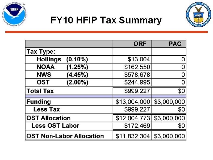
FY 10 HFIP Tax Summary
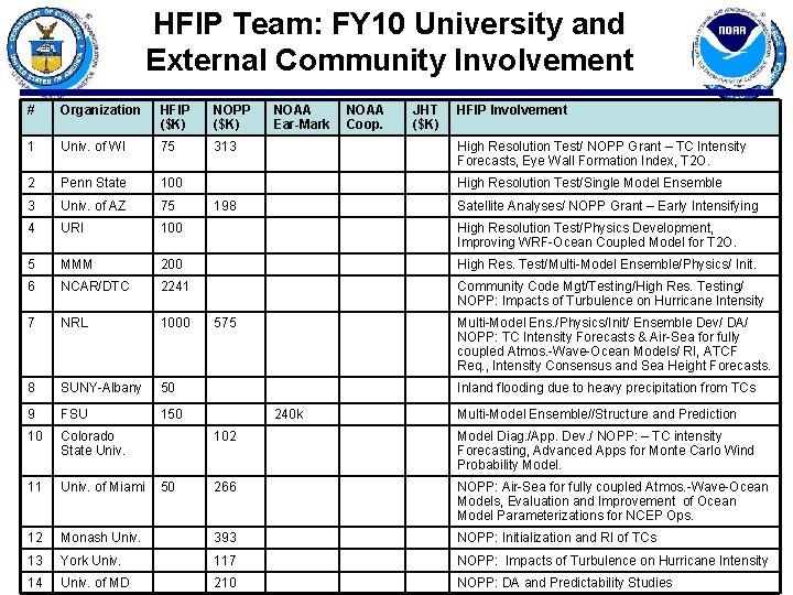
HFIP Team: FY 10 University and External Community Involvement # Organization HFIP ($K) NOPP ($K) NOAA Ear-Mark NOAA Coop. JHT ($K) HFIP Involvement 1 Univ. of WI 75 313 2 Penn State 100 3 Univ. of AZ 75 4 URI 100 High Resolution Test/Physics Development, Improving WRF-Ocean Coupled Model for T 2 O. 5 MMM 200 High Res. Test/Multi-Model Ensemble/Physics/ Init. 6 NCAR/DTC 2241 Community Code Mgt/Testing/High Res. Testing/ NOPP: Impacts of Turbulence on Hurricane Intensity 7 NRL 1000 8 SUNY-Albany 50 9 FSU 150 10 Colorado State Univ. 11 Univ. of Miami 12 High Resolution Test/ NOPP Grant – TC Intensity Forecasts, Eye Wall Formation Index, T 2 O. High Resolution Test/Single Model Ensemble 198 Satellite Analyses/ NOPP Grant – Early Intensifying 575 Multi-Model Ens. /Physics/Init/ Ensemble Dev/ DA/ NOPP: TC Intensity Forecasts & Air-Sea for fully coupled Atmos. -Wave-Ocean Models/ RI, ATCF Req. , Intensity Consensus and Sea Height Forecasts. Inland flooding due to heavy precipitation from TCs 240 k Multi-Model Ensemble//Structure and Prediction 102 Model Diag. /App. Dev. / NOPP: – TC intensity Forecasting, Advanced Apps for Monte Carlo Wind Probability Model. 266 NOPP: Air-Sea for fully coupled Atmos. -Wave-Ocean Models, Evaluation and Improvement of Ocean Model Parameterizations for NCEP Ops. Monash Univ. 393 NOPP: Initialization and RI of TCs 13 York Univ. 117 NOPP: Impacts of Turbulence on Hurricane Intensity 14 Univ. of MD 210 NOPP: DA and Predictability Studies 50
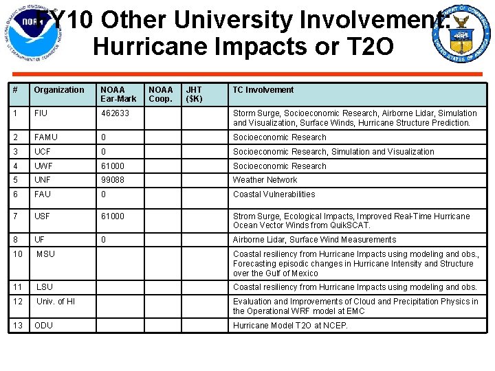
FY 10 Other University Involvement: Hurricane Impacts or T 2 O # Organization NOAA Ear-Mark NOAA Coop. JHT ($K) TC Involvement 1 FIU 462633 Storm Surge, Socioeconomic Research, Airborne Lidar, Simulation and Visualization, Surface Winds, Hurricane Structure Prediction. 2 FAMU 0 Socioeconomic Research 3 UCF 0 Socioeconomic Research, Simulation and Visualization 4 UWF 61000 Socioeconomic Research 5 UNF 99088 Weather Network 6 FAU 0 Coastal Vulnerabilities 7 USF 61000 Strom Surge, Ecological Impacts, Improved Real-Time Hurricane Ocean Vector Winds from Quik. SCAT. 8 UF 0 Airborne Lidar, Surface Wind Measurements 10 MSU Coastal resiliency from Hurricane Impacts using modeling and obs. , Forecasting episodic changes in Hurricane Intensity and Structure over the Gulf of Mexico 11 LSU Coastal resiliency from Hurricane Impacts using modeling and obs. 12 Univ. of HI Evaluation and Improvements of Cloud and Precipitation Physics in the Operational WRF model at EMC 13 ODU Hurricane Model T 2 O at NCEP.
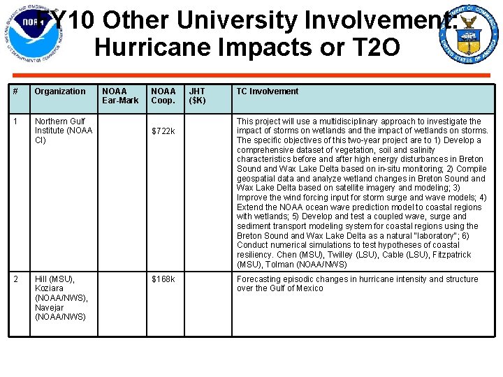
FY 10 Other University Involvement: Hurricane Impacts or T 2 O # Organization 1 Northern Gulf Institute (NOAA CI) 2 Hill (MSU), Koziara (NOAA/NWS), Navejar (NOAA/NWS) NOAA Ear-Mark NOAA Coop. $722 k $168 k JHT ($K) TC Involvement This project will use a multidisciplinary approach to investigate the impact of storms on wetlands and the impact of wetlands on storms. The specific objectives of this two-year project are to 1) Develop a comprehensive dataset of vegetation, soil and salinity characteristics before and after high energy disturbances in Breton Sound and Wax Lake Delta based on in-situ monitoring; 2) Compile geospatial data and analyze wetland changes in Breton Sound and Wax Lake Delta based on satellite imagery and modeling; 3) Improve the wind forcing input for storm surge and wave models; 4) Extend the NOAA ocean wave prediction model to coastal regions with wetlands; 5) Develop and test a coupled wave, surge and sediment transport modeling system for coastal regions using the Breton Sound and Wax Lake Delta as a natural "laboratory"; 6) Conduct numerical simulations to test hypotheses of coastal resiliency. Chen (MSU), Twilley (LSU), Cable (LSU), Fitzpatrick (MSU), Tolman (NOAA/NWS) Forecasting episodic changes in hurricane intensity and structure over the Gulf of Mexico
HFIP Baseline • HFIP Performance Goals Baselines were developed in a white paper authored by James Franklin, dated 5 May 2009. • For both the track and intensity goals, a consensus (equally-weighted average) of operational guidance models was utilized, evaluated for the Atlantic Basin over the period 2006 -2008. • This 3 -year period is adequate because: a. There has been a significant reduction in track error in recent years, and b. Increased tropical cyclone activity in the Atlantic Basin in the last few years allows for more stable statistics over this shorter time period. • For track error, the consensus is very close to the mean skill of the official NHC forecast. Consequently, a 20% improvement in any HFIP guidance over this baseline could reasonably be expected to translate to a 20% improvement in the official forecast.
HFIP Baseline (Track) For comparison, persistence skill and climatology and baseline errors are also shown (PRCL), as are the official forecast errors (OFCL). Forecast errors are in nautical miles.
HFIP Baseline (Intensity) • For intensity, the same set of models used in the operational intensity consensus ICON was used (except that ICON is not computed unless all the member models are present). Evaluation of this consensus was over 2006 -8. • The intensity consensus is actually slightly better than the official forecast, at least beyond 24 hours or so. This, in part, is because: a. This intensity consensus has only been operationally utilized for one year; and b. The NHC’s operational practice of only making incremental changes to the official forecast.
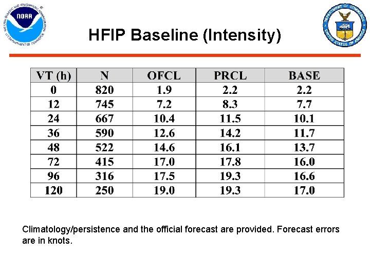
HFIP Baseline (Intensity) Climatology/persistence and the official forecast are provided. Forecast errors are in knots.
HFIP Regional Models Specifications Possible Stream 1. 5 are highlighted in yellow.
HFIP Regional Models Specifications (concluded) Possible stream 1. 5 are highlighted in yellow.
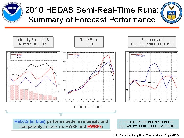
2010 HEDAS Semi-Real-Time Runs: Summary of Forecast Performance Intensity Error (kt) & Number of Cases Track Error (km) Frequency of Superior Performance (%) Forecast Time (hour) HEDAS (in blue) performs better in intensity and comparably in track (to HWRF and HWRFx) All HEDAS results can be found at: https: //storm. aoml. noaa. gov/realtime John Gamache, Altug Aksoy, Tomi Vukicevic, Gopal (HRD)
- Slides: 89