HUNGARIAN PEACEKEEPERS IN AFRICA MINURSO TABLE OF CONTENTS

HUNGARIAN PEACEKEEPERS IN AFRICA MINURSO

TABLE OF CONTENTS • • Geography, Climate Economy, Infrastructure Society, people History MINURSO Structure, Organisation Current situation – possible future

GEOGRAPHY - CLIMATE • Area- 266 000 km • Desert, dry climate • Scant vegetation, plain, low mountains • Borders • 400 km Morocco • 42 km Algeria • 1560 km Mauritania • 110 km shore of Atlantic Ocean

GEOGRAPHY TARFAYA MAROKKÓ ALGERIA TINDOUF FORCE HQ LAAYOUNE ATLANTIC OCEAN Seguia El Hamra SMARA BOUJDOUR del Rio DAKHLA Or o BIR MOGHREIN ZOUERAT NOUADHIBOU MAURITANIA

ECONOMY • One of the poorest region in Africa • Economical Centers • LAAYOUNE, DAKHLA, SMARA • PRODUCTION • Limited agriculture • No industry • Phosphate mining • Fishery

INFRASTRUCTURE • • 4 Center 3 Airport 2 Port 6000 km highway – only 1400 km paved! • ( No railway) LAAYOUNE BOUJDOUR DAKHLA

CRUDE OIL PHOSPHATE FISHERY

SOCIETY

POPULATION TINDOUF LAAYOUNE SMARA ATLANTIC DAKHLA BOUJDOUR • • • POPULATION Laayoune 180, 000 Smara 50, 000 Dakhla 36, 000 Boujdour 14, 000 Nomads 10, 000 Refugees 155, 000 (Tindouf )
 • 1965 DEC 14 : First UN")
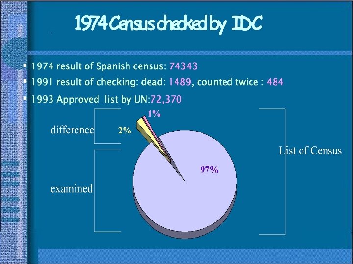
HISTORY I. • Spanish Colony (1884 -1976) • 1965 DEC 14 : First UN resolution (Colony Declaration) • 1973 MAY 10 : Formation of Frente Polisario • 1974 AUG 21: Spanish referendum plan - Census • 1974 DEC 16: Decision of the International Court of Justice (Hague) • 1975 NOV 6 -9 : „Green March”

HISTORY II. Total: 74 343

HISTORY III. • 1975 NOV 14 : Madrid Accord • 1976 FEBR 27 : Declaration the establishment of the SADR • 1976 ÁPR : Morocco and Mauritania invade the territory • 1979 AUG 05 : Peace agreement in Algiers (Polisario and Mauritania) • 1980: „Strategy of walls” (BERM) • 1991 ÁPR 29 : Establish of MINURSO (SC resolution 690) • 1991 SZEPT 05 : Ceasefire

HISTORY IV. • 1997 SZEPT : HOUSTON Agreement • 2000 ÁPR : I. BAKER PLAN (FRAMEWORK AGREEMENT) • 2002: SETTLEMENT PLAN ( II. BAKER PLAN) • 2005: Reduction of MINURSO • 2006: „No war, No peace” situation

„BERM”

CURRENT SITUATION Berm AREA WITH LIMITED RESTRICTIONS MINEFIELD 5 km RESTRICTED ZONE 30 km RESTRICTED ZONE 25 km Berm

IMPORTANCE WS • NATO and EU interest in Afrika (Mediteran Dialogue, Pf. P, economic possibility) • Terrorizm, radical islam, migration, smuggling • Former colonial powers connections and interest (France and Spain) • Morocco, Mauritania, Algeria interest in the conflict - ARAB MAGHREB UNION (AMU) • Hungarian interest in the area

MINURSO STRUCTURE SRSG OFFICE UNHCR CIVILIAN ADMINISTRATION MILITARY OBSERVERS POLICE UNIT DEPARTMENT OF IDENTIFICATION

MILITARY OBSERVERS • Monitor the ceasefire • Monitor the confinement of Moroccan and Polisario troops to designated locations (land air patrols) • activities to reduce the risk of landmines and UXOs in Western Sahara (search, marking safe tracks, destroy, Mine awareness training) • Oversee the exchange of prisoners of war • Take steps with the parties to ensure the release of all Western Saharan political prisoners or detainees! • Implement the repatriation programme

ACTIVITY OF MILITARY OBSERVERS LAAYOUNE HQ Area of responsibility: 266, 000 Sq Km NS : 97 700 Sq Km SS : 159 5000 Sq Km SMARA NS SS SMARA TINDOUF LO BIR LAHLOU MEHAIRES TIFARITI MAURITANIA OUM DREYGA DAKHLA MAHBAS ALGERIA MIJEK HEADQUARTER AWSARD AGWANIT SECTOR HQ+ LO Tindouf CAMPS MAURITANIA

CAMP MEHAIRES - NORTH SECTOR

CURRENT SITUATION POSSIBLE FUTURE • STATUS QUO – extend MINURSO mandate time to time • Referendum based on BAKER II. PLAN, Western-Sahara become part of Morocco, reduced Autonomy • INDEPENDENCE? Divide WS (new idea)? • High tension (POLISARIO) - open a war - defeat

QUESTIONS?
- Slides: 24