HumanEnvironment Interaction If you rode in a car


 • The region of North Africa, Southwest Asia, and")
 • The Strait of Gibraltar separates Africa and Europe")
 • The Suez Canal is a human-made waterway that")
 • The Khyber Pass is a narrow gap between")
 • Ancient Mesopotamia was located on an alluvial plain,")


 • Oil is common in the Persian Gulf because the")
 • Over millions of years, heat and pressure below the")
 • Television and the Internet have exposed the cultures of")
 • Coal, iron ore, and fish are also important resources")
 • Poaching—or illegal fishing or hunting—of sturgeon, the fish whose")
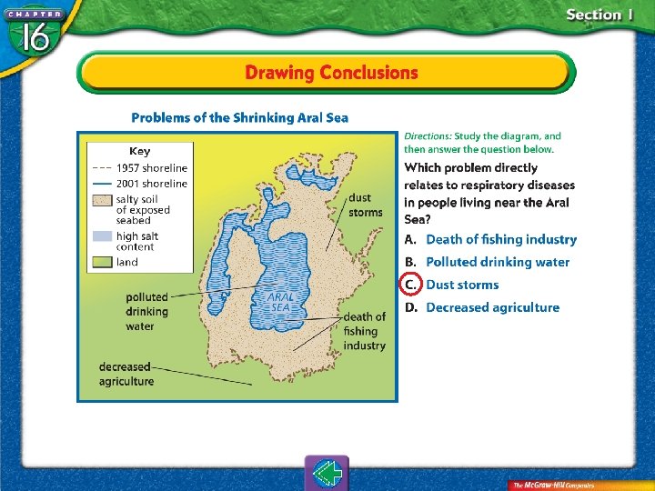
 • The Aral Sea was damaged during the 1960 s")
 • Farmland is both helped and harmed by irrigation. •")
 • The Aswan High Dam on Egypt’s upper Nile River")
 • The Aswan High Dam also causes less freshwater to")
 • Air pollution is a growing problem in the region.")


 • Dry continental air masses warmed by the sun")
 • The Sahara, the world’s largest desert, covers much")
 • Most of the Sahara is dry land covered")
 • In the south of the Arabian Peninsula lies")
 • In Central Asia, rain shadow areas created by")
 • Bordering the region’s deserts are dry, treeless, but")
 • Some people on the steppe live as nomads,")


 • Rainfall is sparse over much of the")
 • Some countries, such as Libya, now draw")
 • Another approach to managing water is desalinization,")


- Slides: 80
Human-Environment Interaction If you rode in a car or a bus to school today, that vehicle’s fuel probably came from the region of North Africa, Southwest Asia, and Central Asia. This region is the world’s leading producer of petroleum and natural gas—two of the main energy sources that power modern society. How have natural resources made this region a key player in world affairs?
Section 1: Physical Features The physical environment affects how people live. For centuries, the people of North Africa, Southwest Asia, and Central Asia have adapted to survive in this dry region. During the past century, however, the increasing global need for petroleum and natural gas has brought new wealth and changing lifestyles to the area.
Section 2: Climate Regions Places reflect the relationship between humans and the physical environment. Many areas of North Africa, Southwest Asia, and Central Asia have harsh environments. As a result, people have settled in areas that can support large populations, such as river valleys. One of the most important challenges facing the region’s people is how to manage water resources to meet their current needs while protecting supplies for the future.
The physical environment affects how people live.
Content Vocabulary • silt • phosphate • alluvial plain • poaching • sedimentary rock • refinery Academic Vocabulary • intense • expose
Chapter Introduction Section 1: Physical Features Section 2: Climate Regions Summary Ed Kashi/CORBIS
Should the United States government fund research for technology that reduces our dependence upon foreign oil? A. Yes B. No A. A B. B
According to myth, the ancient hero Hercules split a mountain in half with his sword, forming the Strait of Gibraltar. On the European side of the strait is the massive Rock of Gibraltar. On the North African side is the Jebel Musa. Together, these rocks are known as the Pillars of Hercules.
The Region’s Landforms This region includes a variety of landforms that affect how and where people live.
The Region’s Landforms (cont. ) • The region of North Africa, Southwest Asia, and Central Asia extends from the Atlantic coast of northwestern Africa to the middle of Asia. • The region is surrounded by oceans, seas, and gulfs that have helped people trade more easily with the rest of Africa, Asia, and Europe.
The Region’s Landforms (cont. ) • The Strait of Gibraltar separates Africa and Europe and links the Mediterranean Sea with the Atlantic Ocean. • The Dardanelles Strait, the Sea of Marmara, and the Bosporus Strait together link the Mediterranean and Black Seas and separate Europe from Asia.
The Region’s Landforms (cont. ) • The Suez Canal is a human-made waterway that allows ships to pass from the Mediterranean Sea to the Red Sea. • North of the Arabian Peninsula, the Strait of Hormuz allows oil tankers to enter and leave the Persian Gulf.
The Region’s Landforms (cont. ) • The Khyber Pass is a narrow gap between mountains in the Hindu Kush, used for centuries as a trade route linking Southwest Asia to other parts of Asia. • The ancient Egyptians relied on the Nile’s yearly flooding, which not only supplied water, but also carried silt—small particles of rich soil that made the land fertile for growing crops.
The Region’s Landforms (cont. ) • Ancient Mesopotamia was located on an alluvial plain, an area of fertile soil left by the flooding of the Tigris and Euphrates Rivers.
Which mountain range is found in the North Africa region? A. Zagros B. Hindu Kush C. Tian Shan D. Atlas A. B. C. D. A B C D
Natural Resources The land in this region is rich in energy resources.
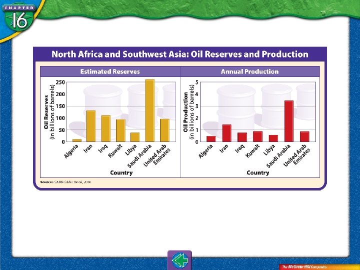
Natural Resources (cont. ) • Oil is common in the Persian Gulf because the land is made up of sedimentary rock, or rock created when layers of material are hardened by the intense weight of more materials piled above.
Natural Resources (cont. ) • Over millions of years, heat and pressure below the Earth’s surface helped turn the remains of sea animals and plants into oil. • Some of the region’s countries have used the wealth gained from selling oil to develop new industries and provide benefits to the region’s people. North Africa and Southwest Asia: Oil Reserves and Production
Natural Resources (cont. ) • Television and the Internet have exposed the cultures of the oil-rich countries to ideas from other parts of the world. • Sometimes this results in conflicts between people who support new ways and people who favor traditional customs and values.
Natural Resources (cont. ) • Coal, iron ore, and fish are also important resources in the region, as are phosphates, mineral salts used to make fertilizer. • Only Lebanon has enough timber to support a lumber industry.
Natural Resources (cont. ) • Poaching—or illegal fishing or hunting—of sturgeon, the fish whose eggs are used to make caviar, has harmed the Caspian Sea and hurt the region’s fishing industry.
Natural Resources (cont. ) • The Aral Sea was damaged during the 1960 s when irrigation projects drained water from the two main rivers that feed the sea. • The water in the Aral Sea also became saltier—unfit for drinking and harmful to the sea’s fish populations.
Natural Resources (cont. ) • Farmland is both helped and harmed by irrigation. • Because the climate is dry, when irrigation water evaporates, it leaves behind a deposit of salt on the land that makes it less fertile or even worthless for farming.
Natural Resources (cont. ) • The Aswan High Dam on Egypt’s upper Nile River controls the river’s floodwaters and enables farmers to grow and harvest food throughout the year. • A disadvantage of the dam is that it has blocked the flow of silt down the river, forcing farmers to turn to chemical fertilizers, which can pollute the Nile.
Natural Resources (cont. ) • The Aswan High Dam also causes less freshwater to flow downriver. • This allows saltwater to back up into the Nile, ruining some farmlands.
Natural Resources (cont. ) • Air pollution is a growing problem in the region. • A large number of cars in the region are older, and they release more pollutants. • Chemicals released by refineries, the facilities that turn petroleum into gasoline and other products, also pollute the air.
Building dams and dikes in the Aral Sea have resulted in: A. Water levels rising B. A reduction of salt levels C. Fish stocks growing D. All of the above A. B. C. D. A B C D
Places reflect the relationship between humans and the physical environment.
Content Vocabulary • wadi • dry farming • erg • aquifer • oasis • rationing • steppe • desalinization • nomad Academic Vocabulary • sparse • adequate
How have water shortages affected your life? A. A great deal B. Very little C. A moderate amount D. Not at all A. B. C. D. A B C D
Although the Sahara region has the world’s hottest temperatures and very little rainfall, scientists believe aquifers underneath the desert might hold as much as 4 billion gallons of water!
A Dry Region Large areas of desert greatly affect life in the region.
A Dry Region (cont. ) • Dry continental air masses warmed by the sun blow over much of North Africa, Southwest Asia, and Central Asia, creating mostly desert land with a dry, hot climate.
A Dry Region (cont. ) • The Sahara, the world’s largest desert, covers much of North Africa. Summer temperatures can climb as high as 136°F (58°C), but winter temperatures are cooler, averaging about 55°F (13°C). • Only about 3 inches (8 cm) of rain fall each year in the Sahara. Dry riverbeds called wadis fill with water when it rains.
A Dry Region (cont. ) • Most of the Sahara is dry land covered with rock or gravel. • About 20 percent of the desert is covered by ergs, or large sand dunes. • The Sahara also contains oases where the land is fertile as a result of water from a spring or well.
A Dry Region (cont. ) • In the south of the Arabian Peninsula lies the Rub’ al Khali, or Empty Quarter, desert, which averages only about 4 inches (10 cm) of rainfall per year.
A Dry Region (cont. ) • In Central Asia, rain shadow areas created by high peaks along with dry continental winds have formed large deserts—the Kara-Kum and the Kyzyl Kum. • Both deserts have hot summers but very cold winters because they are in the middle latitudes.
A Dry Region (cont. ) • Bordering the region’s deserts are dry, treeless, but grassy plains called steppes. • Steppes are found in areas north of the Sahara, in Turkey, and to the east in Central Asia. • Steppe areas receive more rainfall— between 4 and 16 inches (10 and 41 cm) per year—than do deserts.
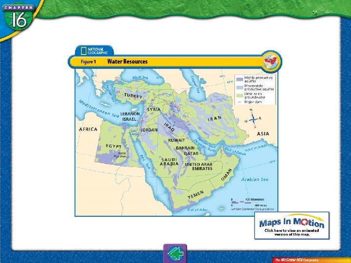
A Dry Region (cont. ) • Some people on the steppe live as nomads, moving across the steppes to find food and water for their herds. • Others in the steppes practice dry farming, a method in which land is left unplanted every few years so that it can store moisture. Water Resources
Which region has the highest concentration of population? A. Highlands of Central Asia B. Coastal areas in North Africa C. Steppes of Turkey D. The Arabian Peninsula A. B. C. D. A B C D
The Need for Water The lack of water is a growing problem in this region.
The Need for Water (cont. ) • Rainfall is sparse over much of the region, so the growing population does not have adequate water to meet its needs. • A large amount of water is used to irrigate dry farmland.
The Need for Water (cont. ) • Some countries, such as Libya, now draw water from aquifers, or underground rock layers though which water flows. • Governments, such as those of Jordan and Syria, are dealing with water shortages by rationing, or making a resource available to people in limited amounts.
The Need for Water (cont. ) • Another approach to managing water is desalinization, a process for making seawater drinkable.
Why is there a shortage of water in these regions? A. Rainfall is sparse. B. Poor countries cannot afford desalinization technology. C. High temperatures cause surface water to evaporate rapidly. D. All of the above A. B. C. D. A B C D
Landforms • The seas bordering the region provide trade routes that connect Europe, Asia, and Africa. • Physical features include mountains, low-lying plains and plateaus, and coastal plains. • Early civilizations based on agriculture developed along several of the region’s rivers. • Tectonic plate movements can cause earthquakes in some parts of the region.
Natural Resources • The region holds much of the world’s oil and natural gas reserves. • Coal, iron ore, and phosphates are among the other valuable mineral resources found in the region.
Environment • Human activities have damaged the Caspian and Aral Seas in recent decades. • Dams and too much irrigation have made areas of land less useful for farming. • Air pollution is a growing problem.
Climates • Vast deserts with dry climates cover much of the region. • The Sahara, the world’s largest desert, covers almost all of North Africa. • Most people live in steppe areas and coastal plains that receive adequate rainfall. • The region’s generally dry climate and a growing population have led to a water shortage.
silt small particles of rich soil
alluvial plain area built up by rich fertile soil left by river floods
sedimentary rock type of rock formed when layers of sediment, or dirt from the ocean floor, are compressed together and harden
phosphate chemical salt used to make fertilizer
poaching illegal fishing or hunting
refinery facility that turns petroleum into gasoline and other products
intense existing in an extreme degree
expose to put on display; to leave without shelter or protection
wadi dry riverbed that fills with water when rare rains fall in a desert
erg large areas of soft sands and dunes in the Sahara
oasis fertile area that rises in a desert wherever water is regularly available
steppe partly dry grassland often found on the edges of a desert
nomad person who lives by moving from place to follow herds of migrating animals to hunt or to lead herds of grazing animals to fresh pasture
dry farming agriculture that conserves water and uses crops and growing methods suited to semiarid environments
aquifer underground layer of rock through which water flows
rationing making a resource available in limited amounts
desalinization process of treating seawater to remove salts and minerals and make it drinkable
sparse few or scattered
adequate enough to satisfy a particular requirement
To use this Presentation Plus! product: Click the Forward button to go to the next slide. Click the Previous button to return to the previous slide. Click the Home button to return to the Chapter Menu. Click the Transparency button from the Chapter Menu, Chapter Introduction, or Visual Summary slides to access the transparencies that are relevant to this chapter. From within a section, click on this button to access the relevant Daily Focus Skills Transparency. Click the Return button in a feature to return to the main presentation. Click the Geography Online button to access online textbook features. Click the Reference Atlas button to access the Interactive Reference Atlas. Click the Exit button or press the Escape key [Esc] to end the chapter slide show. Click the Help button to access this screen. Links to Presentation Plus! features such as Graphs in Motion, Charts in Motion, and figures from your textbook are located at the bottom of relevant screens.
This slide is intentionally blank.