Human Geography Cartography Chapter 1 Thinking Geographically Two


 ADVANTAGE: minimizes shape distortions DISADVANTAGE: interruptions eliminate actual sea areas")


 GIS is very efficient in mapmaking (compared to hand-made maps) -GIS information")

 -initially created for military and commercial aviation -now commonly used")
- Slides: 21
Human Geography & Cartography Chapter 1: Thinking Geographically Two Basic Questions of Geography: 1. WHERE are people and activities found on Earth 2. WHY are they found there After 9/11: WHERE is Afghanistan and WHY were individuals in that country responsible for the attacks? WHERE is Iraq and WHY did U. S. officials find connections between Iraq and U. S. Security?
Two Major Divisions of Geography: 1. Physical Geography—studies where and why natural forces occur as they do 1. -climates, landforms, vegetation… 2. -Topics include Rainforest issues, Desertification, melting ice caps… 2. Human Geography—studies where human activities occur and why they take place at these locations 3. -religions, businesses, cities 4. Important to remember that even when studying human geography, one should not forget how human actions can be influenced by Earth’s physical features 5. -atmosphere, land, water, vegetation, other living
For Example: -when looking at hunger in Somalia, must look at relations between HG: population growth, political unrest, farming practices and PG: drought and climate, environmental degradation -when looking at unrest in the Middle East: HG: distribution of religions, diverse economic strategies PG: energy resources
This Chapter Will Focus on Three Main Issues as a Basic Introduction to This Course: 1. How Do Geographers Describe Where Things Are? 2. 2. Why Is Each Point on Earth Unique? 3. 3. Why Are Different Places Similar?
How Do Geographers Address Where Things Are? Map: geography’s most important tool for thinking spatially about the distribution of features across Earth -a map is a scale model of the real world, made small enough to work with on a desk or a computer Cartography: the science of mapmaking Two Main Purposes of Maps: 1. A tool for storing reference material (atlases, roadmaps) 2. A tool for communicating geographic information 3. -depict the distribution of human activities on physical features
Map Scale -cartographers must decide how much of the Earth’s surface to show on a map -the more area shown on a map, the less detail can be provided Scale: the relationship of a feature’s size on a map Three Ways to Present Scale: 1. Fraction—(1/24, 000) or ratio (1: 24, 000) 1. -one unit on map represents 24, 000 of the same units on Earth 2. Written statement— “one inch equals one mile” 3. A graphic bar scale--
US Census Bureau can create maps showing great neighborhood details
US Census Bureau can also show maps at city-scale levels
Larger regions can be mapped as well
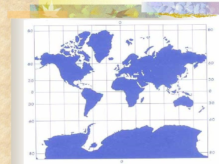
The more area that is mapped, the less detail can go onto the map Map Projection Globe: the most accurate way to display the Earth -but, a very large globe is needed to show many details -globes make it difficult to show a smaller area -globes are bulky and cumbersome Projection: the scientific method of transferring locations on Earth’s surface to a flat map -when taking Earth’s locations and transferring them onto a flat surface, distortion can result
Four Types of Distortion 1. Shape can be distorted (may appear more elongated or squat) 2. Distance can be distorted 3. Relative size can be distorted (one area may appear larger, but may actually be smaller) 4. Direction between places can be distorted
Types of Projections: Mercator Projection -distortions near the poles as they are extended -ADVANTAGE: shape and direction -DISADVANTAGE: areas are distorted especially nearer the poles
Equal-Area Projection (Goode's Homolosine) ADVANTAGE: minimizes shape distortions DISADVANTAGE: interruptions eliminate actual sea areas
Robinson Projection: ADVANTAGE: uninterrupted, useful to show information across oceans DISADVANTAGE: land areas are much smaller
U. S. Land Ordinance of 1785: -divided much of the United States into a system of townships and ranges -this was done to help in the sale of western lands Township: a square 6 miles on each side -each township has an identification number based on its location -each township is divided into 36 sections -each section is divided into 4 quarter sections -160 acres, ½ mile by ½ mile Locations can be described within a township
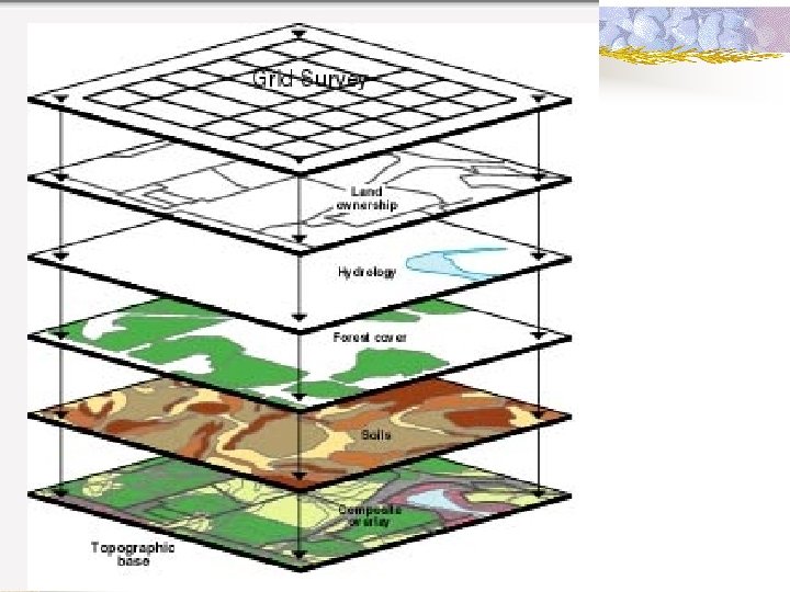
Contemporary Geography Tools: -accurately mapping Earth’s surface has taken several centuries -now, new tools are being used to learn more about the characteristics of places GIS (Geographic Information Systems) -a computer system that can capture, store, query, analyze, and display geographic data Geocoding: the key to GIS -any object on Earth can be measured and recorded with mathematical precision, then stored onto a computer -map is created when the computer retrieves a number of stored objects and combines them into an image
GIS (continued) GIS is very efficient in mapmaking (compared to hand-made maps) -GIS information is stored in layers -you can turn layers on and off in GIS systems -layers can be compared with each other to show relationships among different types of information i. e. : a relationship to cancer rates combined with location of people with various incomes and ethnicities, location of factories, locations of winds
Remote Sensing: the acquisition of data about Earth’s surface from a satellite or from other long-distance methods -images are transmitted from the satellite to a receiving station -remote sensing is used primarily for environmental applications -identifying crops, vegetation, and other surface cover The smallest feature on Earth’s surface that can be detected by a sensor is the resolution of the sensor
GPS (Global Positioning System) -initially created for military and commercial aviation -now commonly used by individuals for recreation -GPS also found on many automobiles -can help determine the location of an emergency -accurately determines the precise position of something on Earth