How well can we model air pollution meteorology

- Slides: 22

How well can we model air pollution meteorology in the Houston area? Wayne Angevine CIRES / NOAA ESRL Mark Zagar Met. Office of Slovenia Jerome Brioude, Robert Banta, Christoph Senff, Hyun. Cheol Kim, Daewon Byun

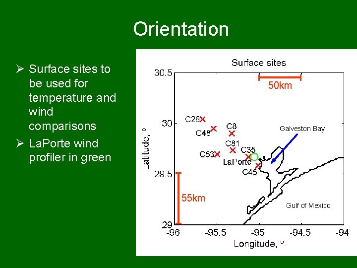
Orientation Ø Surface sites to be used for temperature and wind comparisons Ø La. Porte wind profiler in green 50 km Galveston Bay 55 km Gulf of Mexico

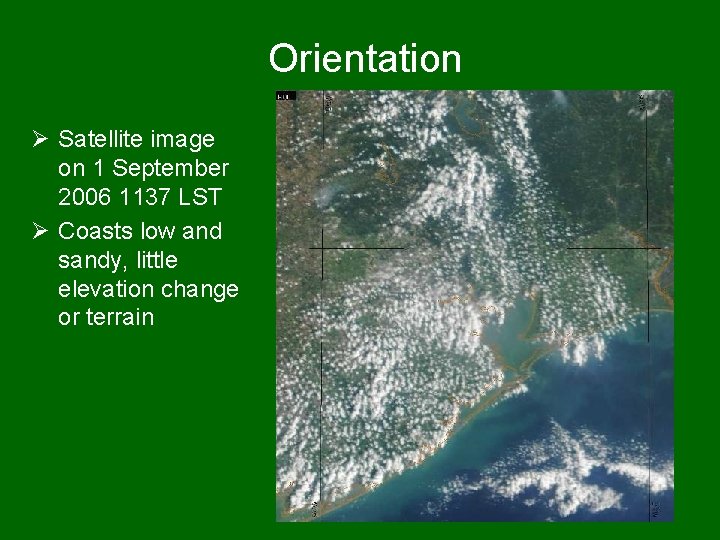
Orientation Ø Satellite image on 1 September 2006 1137 LST Ø Coasts low and sandy, little elevation change or terrain

Measurements and simulations Ø Texas Air Quality Study II (August. October 2006) Ø Surface meteorological and pollution monitoring sites Ø Mixing heights and winds from a radar wind profiler at La. Porte (on land) Ø WRF simulations

How can we tell if one model run is better than another? Ø Need metrics that clearly show improved performance Ø Several approaches: – Traditional bulk statistics – Case studies – Sea breeze and stagnation frequency – Plume locations

WRF simulations Ø 75 days, 1 August – 14 October 2006 Ø 5 km inner grid spacing Ø Three styles: – FDDA of 3 wind profilers, reduced soil moisture, and hourly SST – FDDA of 3 wind profilers and reduced soil moisture – Reduced soil moisture only Ø All with ECMWF initialization every 24 hours (at 0000 UTC) Ø Retrospective runs, not forecasts

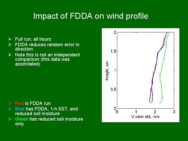
Impact of FDDA on wind profile Ø Full run, all hours Ø FDDA reduces random error in direction Ø Note this is not an independent comparison (this data was assimilated) Ø Red is FDDA run Ø Blue has FDDA, 1 -h SST, and reduced soil moisture Ø Green has reduced soil moisture only

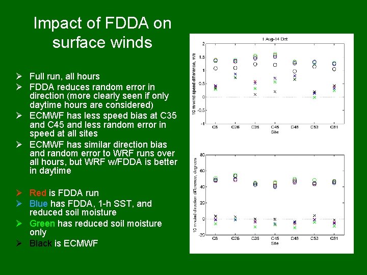
Impact of FDDA on surface winds Ø Full run, all hours Ø FDDA reduces random error in direction (more clearly seen if only daytime hours are considered) Ø ECMWF has less speed bias at C 35 and C 45 and less random error in speed at all sites Ø ECMWF has similar direction bias and random error to WRF runs over all hours, but WRF w/FDDA is better in daytime Ø Red is FDDA run Ø Blue has FDDA, 1 -h SST, and reduced soil moisture Ø Green has reduced soil moisture only Ø Black is ECMWF

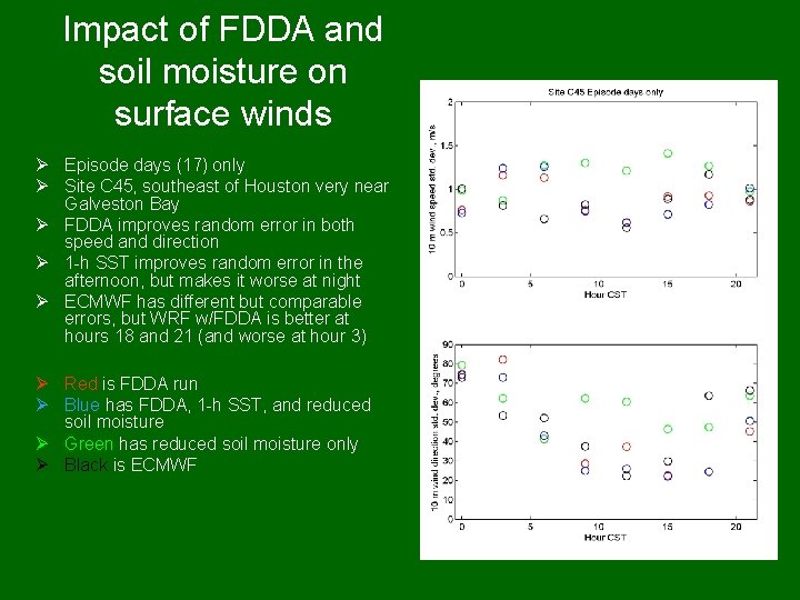
Impact of FDDA and soil moisture on surface winds Ø Episode days (17) only Ø Site C 45, southeast of Houston very near Galveston Bay Ø FDDA improves random error in both speed and direction Ø 1 -h SST improves random error in the afternoon, but makes it worse at night Ø ECMWF has different but comparable errors, but WRF w/FDDA is better at hours 18 and 21 (and worse at hour 3) Ø Red is FDDA run Ø Blue has FDDA, 1 -h SST, and reduced soil moisture Ø Green has reduced soil moisture only Ø Black is ECMWF

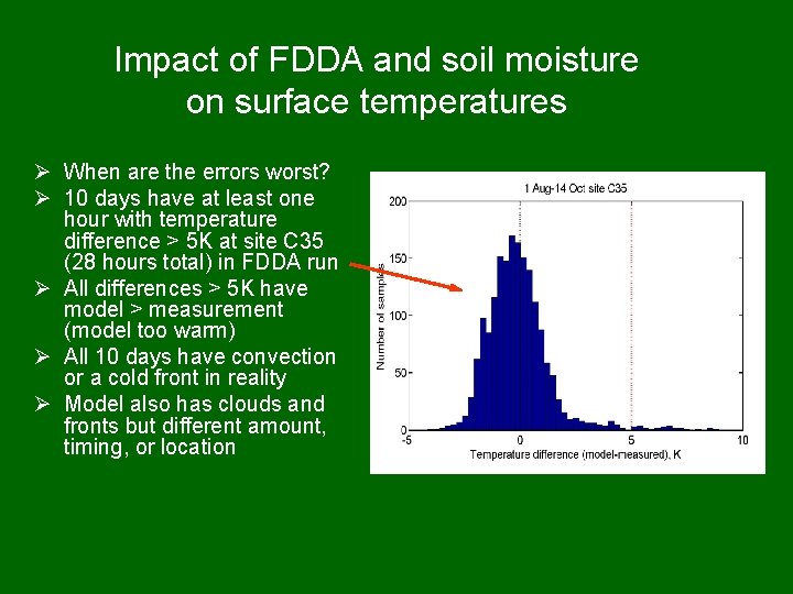
Impact of FDDA and soil moisture on surface temperatures Ø When are the errors worst? Ø 10 days have at least one hour with temperature difference > 5 K at site C 35 (28 hours total) in FDDA run Ø All differences > 5 K have model > measurement (model too warm) Ø All 10 days have convection or a cold front in reality Ø Model also has clouds and fronts but different amount, timing, or location

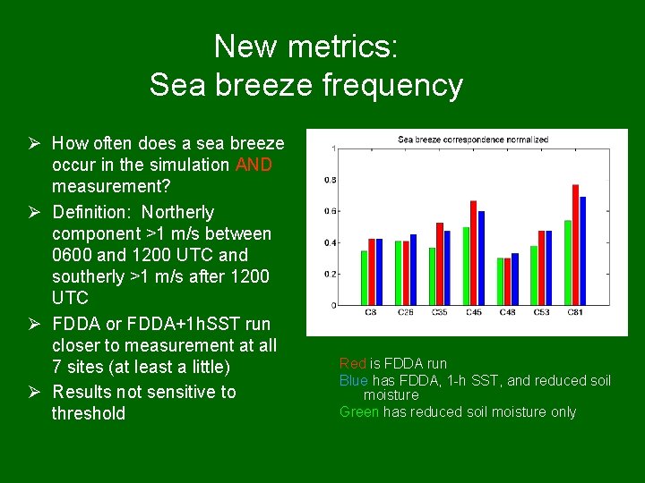
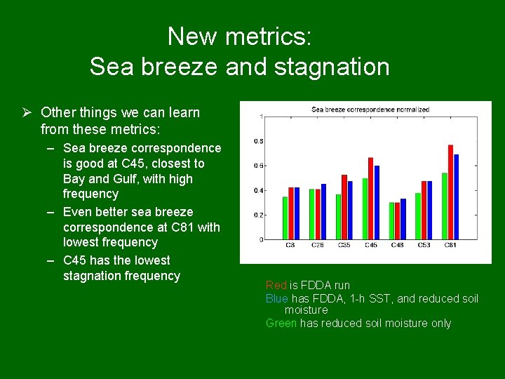
New metrics: Sea breeze frequency Ø How often does a sea breeze occur in the simulation AND measurement? Ø Definition: Northerly component >1 m/s between 0600 and 1200 UTC and southerly >1 m/s after 1200 UTC Ø FDDA or FDDA+1 h. SST run closer to measurement at all 7 sites (at least a little) Ø Results not sensitive to threshold Red is FDDA run Blue has FDDA, 1 -h SST, and reduced soil moisture Green has reduced soil moisture only

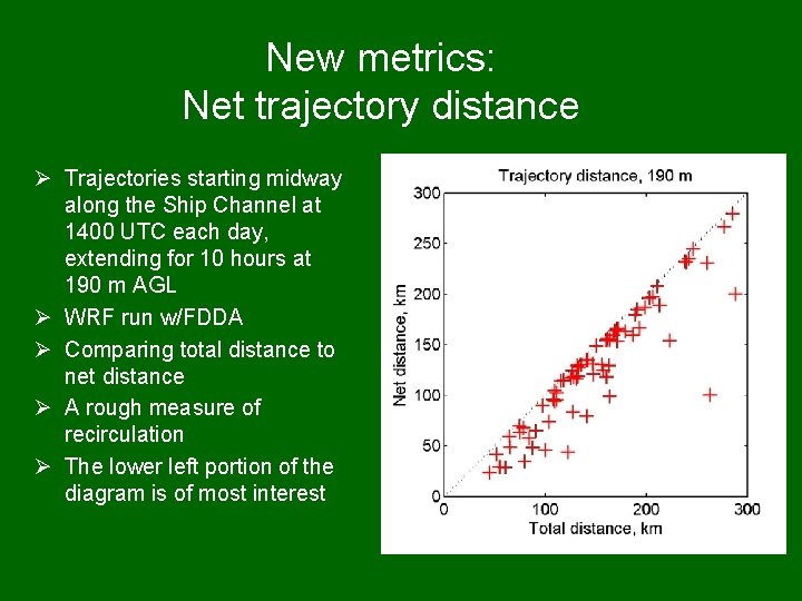
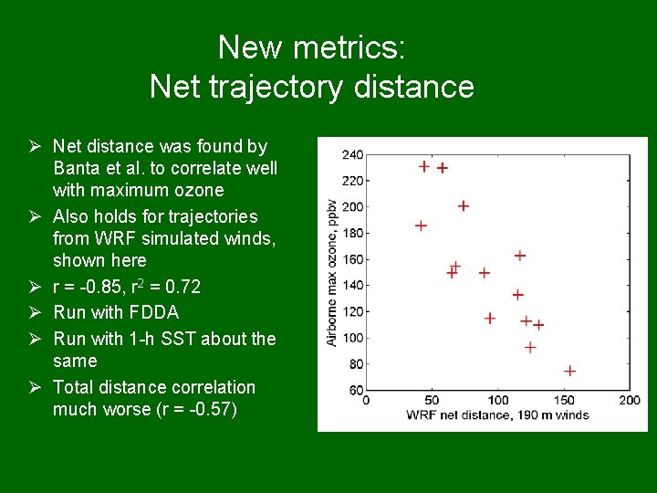
New metrics: Net trajectory distance Ø Trajectories starting midway along the Ship Channel at 1400 UTC each day, extending for 10 hours at 190 m AGL Ø WRF run w/FDDA Ø Comparing total distance to net distance Ø A rough measure of recirculation Ø The lower left portion of the diagram is of most interest

New metrics: Net trajectory distance Ø Net distance was found by Banta et al. to correlate well with maximum ozone Ø Also holds for trajectories from WRF simulated winds, shown here Ø r = -0. 85, r 2 = 0. 72 Ø Run with FDDA Ø Run with 1 -h SST about the same Ø Total distance correlation much worse (r = -0. 57)

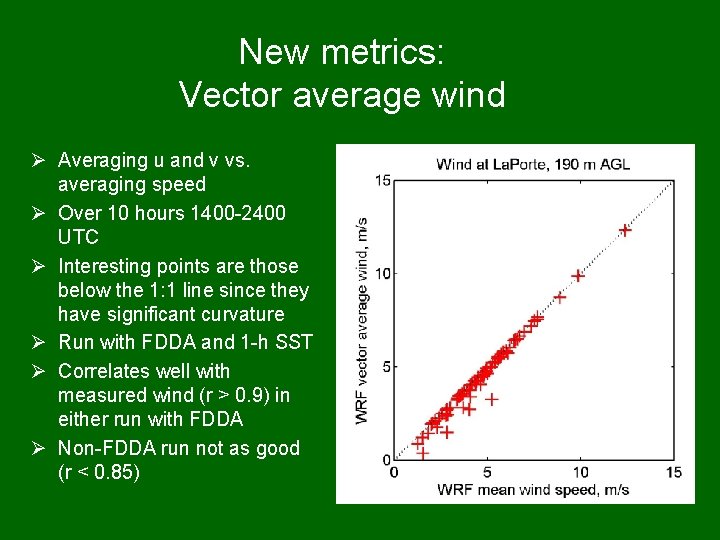
New metrics: Vector average wind Ø Averaging u and v vs. averaging speed Ø Over 10 hours 1400 -2400 UTC Ø Interesting points are those below the 1: 1 line since they have significant curvature Ø Run with FDDA and 1 -h SST Ø Correlates well with measured wind (r > 0. 9) in either run with FDDA Ø Non-FDDA run not as good (r < 0. 85)

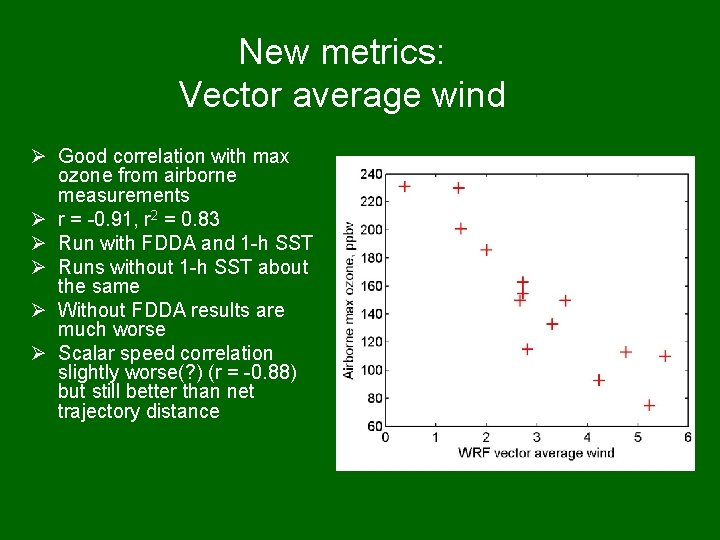
New metrics: Vector average wind Ø Good correlation with max ozone from airborne measurements Ø r = -0. 91, r 2 = 0. 83 Ø Run with FDDA and 1 -h SST Ø Runs without 1 -h SST about the same Ø Without FDDA results are much worse Ø Scalar speed correlation slightly worse(? ) (r = -0. 88) but still better than net trajectory distance

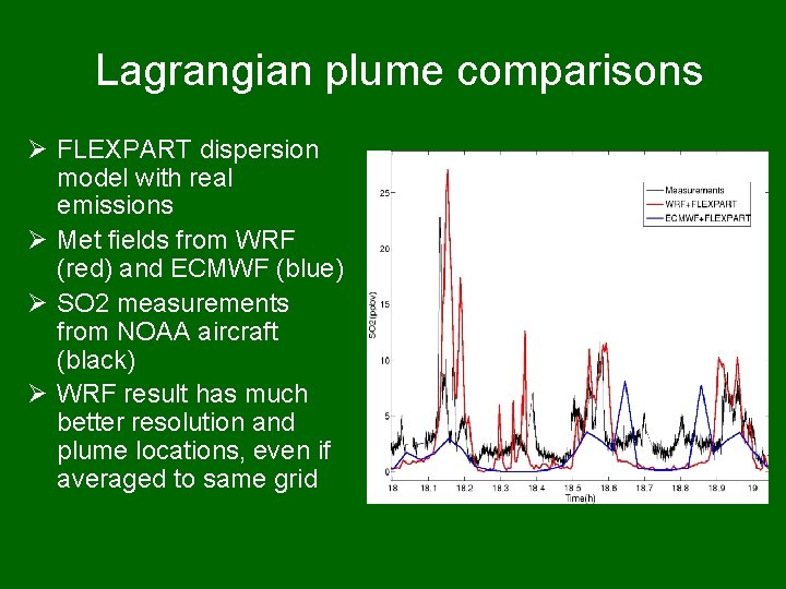
Lagrangian plume comparisons Ø FLEXPART dispersion model with real emissions Ø Met fields from WRF (red) and ECMWF (blue) Ø SO 2 measurements from NOAA aircraft (black) Ø WRF result has much better resolution and plume locations, even if averaged to same grid

Conclusions Ø ECMWF model used for initialization is already quite good, making it difficult to demonstrate improvement with high-resolution simulations Ø Traditional statistics (bias and std. dev. ) don’t crisply display differences between runs, although they generally indicate improvement with FDDA – Different sites show different results Ø Looking at distribution of errors is useful – Large errors in temperature (>5 K) occur when moist convection is present Ø New metric of sea breeze correspondence shows improvement at all 7 surface sites with FDDA Ø Net trajectory distance correlates better with ozone than total distance Ø Vector average wind correlates still better with ozone, scalar average wind speed almost as good Ø Average wind (vector or scalar) shows clearly that FDDA makes an important improvement under high-ozone conditions Ø Improvement above the surface is easy to demonstrate (eg. by comparison with wind profiler data) Ø Lagrangian plume model provides clear information about directly relevant performance of the model, but how to encapsulate? Ø Uncertainty analysis is needed Ø How good is good enough? Ø What if we know we have improved the model, but can’t show that we have improved the results?

Thanks to: Ø Bryan Lambeth, Texas Commission on Environmental Quality Ø NOAA P 3 scientists Ø Richard Pyle and Vaisala, Inc. for funding Ø and many others

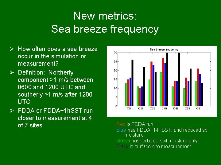
New metrics: Sea breeze frequency Ø How often does a sea breeze occur in the simulation or measurement? Ø Definition: Northerly component >1 m/s between 0600 and 1200 UTC and southerly >1 m/s after 1200 UTC Ø FDDA or FDDA+1 h. SST run closer to measurement at 4 of 7 sites Red is FDDA run Blue has FDDA, 1 -h SST, and reduced soil moisture Green has reduced soil moisture only Black is surface site measurement

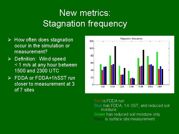
New metrics: Stagnation frequency Ø How often does stagnation occur in the simulation or measurement? Ø Definition: Wind speed < 1 m/s at any hour between 1500 and 2300 UTC Ø FDDA or FDDA+1 h. SST run closer to measurement at 3 of 7 sites Red is FDDA run Blue has FDDA, 1 -h SST, and reduced soil moisture Green has reduced soil moisture only Black is surface site measurement

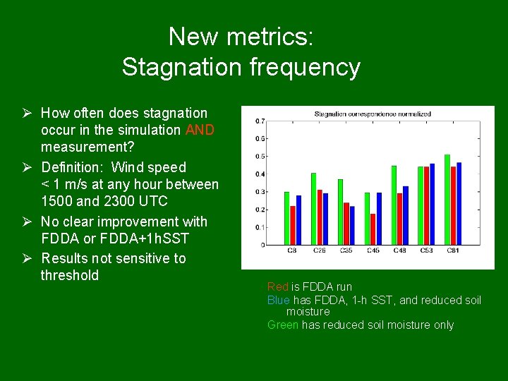
New metrics: Stagnation frequency Ø How often does stagnation occur in the simulation AND measurement? Ø Definition: Wind speed < 1 m/s at any hour between 1500 and 2300 UTC Ø No clear improvement with FDDA or FDDA+1 h. SST Ø Results not sensitive to threshold Red is FDDA run Blue has FDDA, 1 -h SST, and reduced soil moisture Green has reduced soil moisture only

New metrics: Sea breeze and stagnation Ø Other things we can learn from these metrics: – Sea breeze correspondence is good at C 45, closest to Bay and Gulf, with high frequency – Even better sea breeze correspondence at C 81 with lowest frequency – C 45 has the lowest stagnation frequency Red is FDDA run Blue has FDDA, 1 -h SST, and reduced soil moisture Green has reduced soil moisture only