How The Last Ice Age Shaped Canada What


 At the base of the glacier, large amounts")
 The glacier picks up or “plucks” rocks and")


- Slides: 22
How The Last Ice Age Shaped Canada
What Were The Ice Ages? • The Ice Ages began 2. 4 million years ago and lasted until 12, 500 years ago. • Glacials: cold periods during which glaciers covered large parts of the world • Interglacials: very warm periods during which many of the glaciers melted.
Ice Ages Cycle
Why were there Ice Ages? • Many causes have been suggested for the ice ages including: – changes in solar flux – changes in the shape of Earth’s orbit & the tilt of its axis Probably it was a combination of several such influences.
The Pleistocene Epoch • The Pleistocene Epoch is the actual name for the time period • This period is the first in which Homo sapiens evolved, and by the end of the epoch humans could be found in nearly every part of the planet.
The Last Ice Age • The world's most recent glacial period began about 110, 000 years ago and ended around 12, 500 years ago.
Laurentide Ice Sheet • A massive ice sheet that covered most of Canada and a large portion of the northern US • It covered most of northern North America between 95, 000 and 20, 000 years ago. • It created much of the surface geology of the area, leaving behind many glacial landforms
Retreat of the Laurentide Ice Sheet • As the ice sheet retreated, it left behind many large glacial lakes
How Do Glaciers Form Landscapes? 1) At the base of the glacier, large amounts of loose rock and sediment are stuck to the moving ice • Then the ice sheet acts like sandpaper and scours the land underneath • Scouring can cause scratch marks on the rock (striations) • It can polish the rock smooth (glacial polish) • It can also wear off a fine sediment transported away from the glacier by meltwater
How Do Glaciers Form Landscapes 2) The glacier picks up or “plucks” rocks and objects as it moves. • All glacial deposits are by and large known as glacial drift.
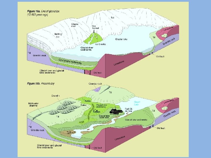
Glacial Landforms Till: the sediments in a glacier, they can be deposited around the edge of a glacier Moraine: the hill created from the deposit of till from a glacier (similar to an esker, a drumlin) Erratic: a boulder transported a long distance by a glacier Kettle Hole: the hole or lake created from a leftover chunk of glacial ice
Land Formations Caused by Retreating Glaciers
Toronto’s Ice Age • When ice sheets are thick they pick up material, but when they finally melt, they drop a mixture of sediment that geologists call till.
Great Lakes and Lowlands • Most of the Great Lakes’ basins were carved out by the moving ice. • Soil and rocks were scooped off the Canadian Shield and deposited over southern parts such as Toronto.
Formation of the Great Lakes
Toronto Drumlins • Toronto has several drumlins, ridges created by glaciers.
Don Valley • The deep wide lower Don valley was formed after the draining of Lake Iroquois (a huge glacial lake) • Many streams, including The Don, cut deep U-shapes ravines through the previously V-shaped valley
Toronto’s Lakeshore • Modern Lake Ontario is within the bed of ancient Lake Iroquois, a meltwater lake that rose while Ice Age glaciers blocked the outlet of the Saint Lawrence River to the sea. • Today Lake Ontario's shoreline landform varies considerably over the length of metropolitan Toronto.
Oak Ridges Moraine • North of the city, the hills and valleys of the Oak Ridges Moraine rise 820 feet above lake level. • The moraine's spongy wetlands and soil were deposited 12, 000 years ago from the retreating Wisconsin Glacier, and are now the headlands of 65 streams, of which 35 pass through the Greater Toronto Area.
The Toronto Islands • The Scarborough Bluffs, for instance, are a section of the Lake Iroquois shoreline. • Toronto Islands were created from sand deposits near the mouth of the Don River, forming a long, sandy spit that would eventually be the Toronto Islands.
Ice Age Videos • http: //www. youtube. com/watch? v=d. J 5 GYQrkvx. I • 2: 08 “What is an Ice Age? ” • http: //www. youtube. com/watch? v=x 12 KS 936_f. M – 44: 04 “North American Ice Age”