Horizontal Datums in the United States NAD 27
,")


 • • • Took place from 1974 to 1986 Digitized observations")
 DOPPLER STATIONS")
 • There were no GPS observations in NAD 83")


 • Network Accuracy - 1 Meter • Local Accuracy")
 Not “GPSABLE” POOR STATION ACCESSIBILITY IRREGULARLY SPACED POSITIONAL ACCURACY")


 Readjustment • • Multiple epoch dates Inconsistencies between states")


 New NGS airborne meter (R) Portable absolute meter (A 10)")
 READJUSTMENT ONLY GPS DATA WAS USED CORS (started in 1994)")


 • • •")


/DF • A is")
 < 5 cm. in the horizontal component with an average shift")

 from 1994 to")
")
 v NAD 83 (CORS 96) • “… approximates but is")


- Slides: 64
Horizontal Datums in the United States: NAD 27 and flavors of NAD 83 (1986), NAD 83(HARN) and NAD 83 (NSRS 2007) GISC 3325 10 March 2008
Class Update • Exam Wednesday during class and lab periods. • Covers all labs, required readings, lectures and Chapters 5 -7 of text. • Computations like those demonstrated in class will be part of the test.
www. ngs. noaa. gov Gravity For the American Vertical Datum
What did NAD 83 replace?
NAD 27 • 1927 – NAD 27 becomes the 2 nd continuous, continental scale datum of the United States – Terrestrial measurements – Distances measured manually – Origin point in Kansas Meades Ranch
Problems with NAD 27 • First-order surveys designed with an accuracy goal of 1: 25, 000 • Network was adjusted piecewise rather than simultaneously. • Underlying measurements used were of relatively poor precision. • It was not geocentric • Reference ellipsoid used (Clarke 1866) was not appropriate for space-based positioning.
NAD 83 (1986) • • • Took place from 1974 to 1986 Digitized observations from 1800’s to 1980’s 300 persons worked on the project $37 M (in 1974 dollars) 1 million simultaneous equations – Helmert blocking • Doppler and VLBI used but mostly terrestrial observations. NO GPS!!!! • NAD 83 datum moved to Center-Of-Mass of Earth
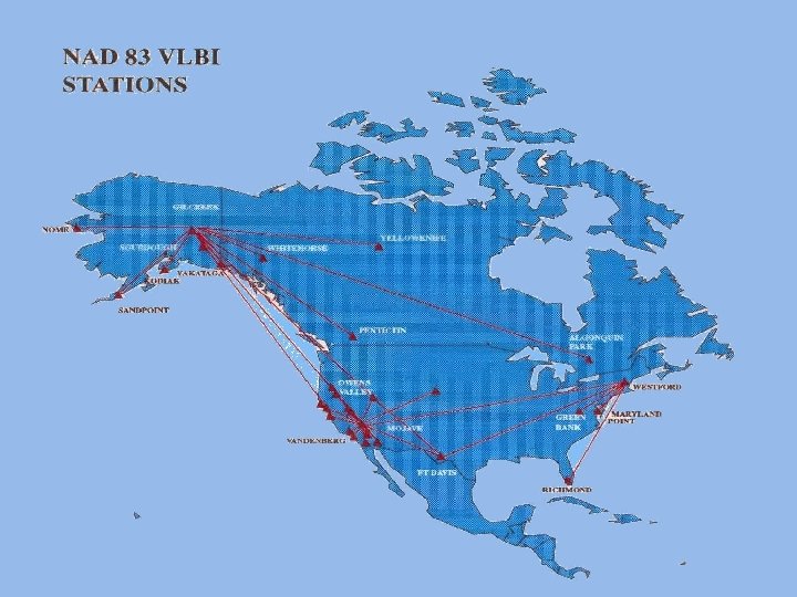
NAD 83(86) DOPPLER STATIONS
GPS with NAD 83 (1986) • There were no GPS observations in NAD 83 (1986) • With GPS we see: – Accuracy greatly exceeds EDM – Allows connection between points that are not intervisible – Provides ellipsoid heights • Required creation of geoid models (first: Geoid 90) to link ellipsoid to NAVD 88
COMPARISON OF DATUM ELEMENTS NAD 27 NAD 83 ELLIPSOID CLARKE 1866 a=6, 378, 206. 4 m 1/f = 294. 9786982 GRS 80 a=6, 378, 137 m 1/f = 298. 257222101 DATUM POINT Triangulation Station Meades Ranch, Kansas NONE Earth Mass Center ADJUSTMENT 25 k Stations few hundred Base lines few hundred Astro Az 250 k Stations 30 k EDMI base lines 5 k Astro Azimuths Doppler and VLBI
NAD 27 and NAD 83
Results of NAD 83 (1986) • Network Accuracy - 1 Meter • Local Accuracy – First-Order (1 part in 100, 000)
PROBLEMS with NAD 83 (1986) Not “GPSABLE” POOR STATION ACCESSIBILITY IRREGULARLY SPACED POSITIONAL ACCURACY inadequate for GPS observations
HIGH PRECISION GPS NETWORKS “GPSABLE” Clear Horizons for use with Satellites EASY ACCESSIBILITY Few Special Vehicle or Property Access Requirements REGULARLY SPACED Always within 20 -100 Km HIGH HORIZONTAL ACCURACY A-Order (5 mm + 1: 10, 000) B-Order (8 mm + 1: 1, 000)
HARN/HPGN ADJUSTMENT A-Order Adjusted to VLBI-Existing FBNCORS B-Order Adjusted to A-Order Existing Horizontal (Conventional & GPS) Readjusted to A/B-Order Adopted Adjustment Date Tags e. g. NAD 83(1991)
HIGH ACCURACY REFERENCE NETWORK
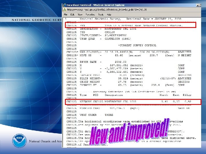
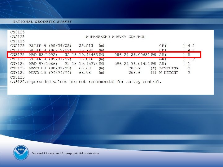
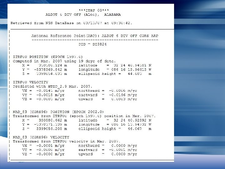
Old Datasheet format
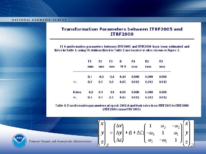
DX = 0. 5378 DY = -1. 4980 DZ = 0. 1726 - or DN = -0. 6743 DE = 0. 4393 DU = 1. 3840
IMPROVING POSITIONAL ACCURACY NETWORK TIME SPAN NETWORK ACCURACY LOCAL ACCURACY NAD 27 1927 -1986 10 METERS (1 part in 100, 000) NAD 83(1986) 1986 -1990 1 METER (1 part in 100, 000) HARN 1990 -1997 0. 1 METER B-order (1. 0 ppm) A-order (0. 1 ppm) CORS 1996 - 0. 01 meter
New Adjustment Network Accuracies • Median horizontal network accuracy: 1 cm • Median vertical network accuracy: 2 cm
Reasons for NAD 83 (2007) Readjustment • • Multiple epoch dates Inconsistencies between states Need to be Consistent with CORS Compute Network and Local accuracies September 24, 2003 NGS Executive Steering Committee approved a plan for the readjustment of the horizontal positions and ellipsoid heights for GPS stations in the contiguous United States. Orthometric Height adjustment will not be attempted
What about Orthometric Heights? Ø Decision was made not to perform a National Readjustment of orthometric heights at this time Ø Control would be NAVD 88 not the CORS Ø No analysis of NAVD 88 control
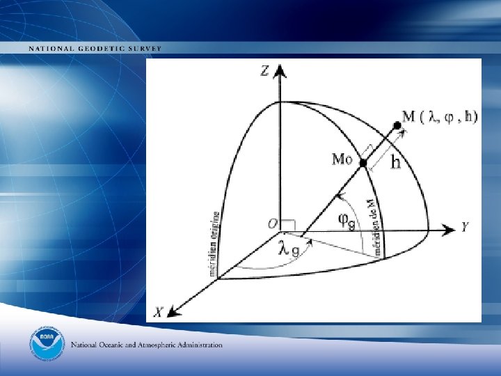
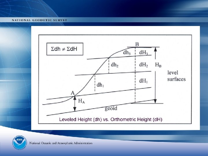
Heights h – H – N = 0 + errors in components
GPS on Benchmark data for GEOID 2003 h – H – N = 0 + errors in components
“Perfect” CORS
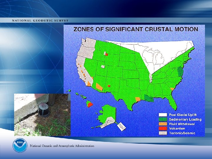
Tectonic Plates NUVEL-1 A
Geoid Modeling Issues • The new ellipsoid heights will be used in the next hybrid Geoid model. • Future efforts will center on improvements to our gravity data. • NGS has acquired an airborne gravity meter. • We plan a comprehensive set of observations to capture gravity throughout the United States and our possessions. • Airborne gravity data supplements terrestrial and satellite based gravity.
(L) New NGS airborne meter (R) Portable absolute meter (A 10)
NAD 83 (NSRS 2007) READJUSTMENT ONLY GPS DATA WAS USED CORS (started in 1994) FEDERAL BASE NETWORK (A & B) COOPERATIVE BASE NETWORK (B) USER DENSIFICATION NETWORK (First) AIRPORT SURVEYS (B & First) A simultaneous rather than layered adjustment strategy was adopted using Helmert blocking.
Readjustment General Comments Ø The CORS/CGPS were the control Ø Only GPS projects participated Ø The FBN/CBN Surveys are a key element Ø Tied to the CORS Ø Provide more accurate ellipsoid heights
More Comments Ø Computation and database loading of scale factors for each project. Ø Projects re-weighted in both horizontal and vertical (ellipsoid). Ø Statewide GPS Readjustments provided extra information about the network on a state-by-state basis. Ø Work in NAD 83 Ø Transform to ITRF later
Network Accuracy Ø Network accuracy of a control point Ø A value that represents the uncertainty of its coordinates with respect to the geodetic datum at the 95 -percent confidence level Ø Datum is considered to be best expressed by the Continuous Operating Reference Stations (CORS) Ø Local and Network accuracy values at CORS sites are considered to be infinitesimal (approach zero) Ø These accuracies were implemented with the National Readjustment
Local Accuracy Ø Local Accuracy of a control point: Ø A value that represents the uncertainty of its coordinates relative to other directly connected, adjacent control points at the 95 -percent confidence level Ø An approximate average of the individual local accuracy values between this control point and other observed control points used to establish its coordinates
NEW STANDARDS FOR GEODETIC CONTROL (http: //fgdc. er. usgs. gov/standards/status/swgstat. html) • • • local accuracy ------- adjacent points network accuracy ----- relative to CORS Numeric quantities, units in cm (or mm) Both are relative accuracy measures Will not use distance dependent expression Order/Class codes will no longer be used
N HEIGHT is precisely determined but only tied to one published benchmark
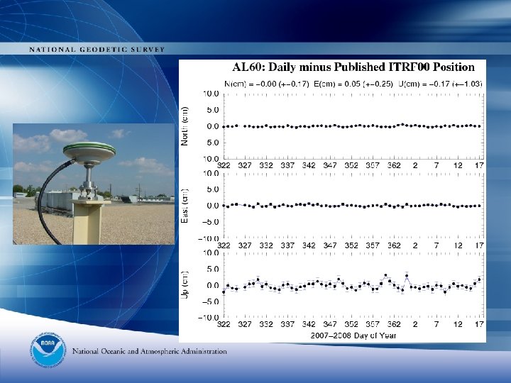
Computations of accuracies This is an extract from an OPUS extended solution.
Annoying details X = ATWA-1*ATWL V = A*X-L σ2 = (VTWV)/DF • A is the design matrix • L is a matrix of observations • W is a weight matrix • X is the vector of unknowns • Q is the variancecovariance matrix (ATA)-1 Accuracy of a quantity is determined by multiplying standard deviation of variances by diagonal element of the Q matrix.
SHIFTS (National results) < 5 cm. in the horizontal component with an average shift of 2. 2 cm. < 10 cm. in the vertical component with an average shift of 4. 6 cm.
ISSUES New realization of the CORS coordinates are not available -we recommend using the 2002 coordinates as published. The new Policy statement is posted on the NSRS Readjustment webpage. Another adjustment MAY be run after the next CORS realization (2005) is released and new CORS coordinates published.
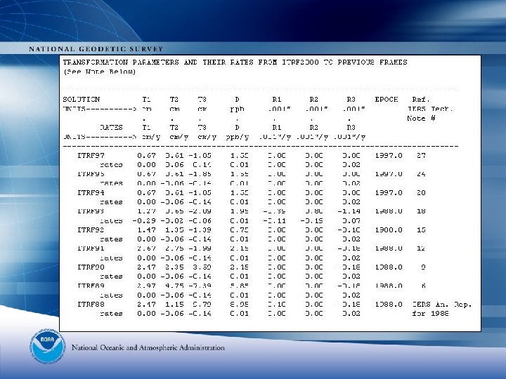
ITRF and WGS 84 from 1987 to 1994, WGS 84(G 730) from 1994 to 1996, WGS 84(G 873) from 1997 to 2002 and WGS 84(G 1150) from 2002 to present.
ITRF to NAD 83 (? ? )
NAD 83 (NSRS 2007) v NAD 83 (CORS 96) • “… approximates but is not equivalent to the more rigorously defined NAD 83 (CORS 96) realization in which CORS coordinates are distributed. ” • “ …should be consistent with corresponding NAD 83 (CORS 96) positional coordinates to within the accuracy of GPS data used and the accuracy of the corrections applied…” • NAD 83 (NSRS 2007) coordinates do not account for vertical crustal motion. • NGS did not compute velocities for any of the passive monuments involved in the adjustment.
NSRS 2007 adjustment Ø Ø 3, 411 projects 67, 693 points 283, 691 vectors 673 CORS fixed No. of constrained parameters = 2055 No. of unknown parameters = 203, 076 Degrees 0 f Freedom = 650, 049 Ø Constraints in adjustment: 471 National CORS, 3 Canadian CACS, 1 Mexican CORS and 213 California CGPS sites
Overall NAD 83 NSRS 2007 results • Median horizontal network accuracy: 1 cm – Median hz. adj vector residual: 0. 52 cm • Median vertical network accuracy: 2 cm – Median vt. adj vector residual: 0. 54 cm
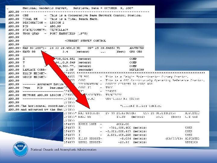
Same data in datasheet format
Time-line for National Readjustment Positions and Ellipsoid Heights All projects loaded in the NGS database prior to November 15, 2005 were included in the National Readjustment Projects submitted after 11/15/2005 were accepted and loaded into the database but were not included in the readjustment Completed adjustment by February 10, 2007 deadline. New Datasheets including new positions and network accuracies are available NOW. Project Report (pending)