Horizontal and vertical angles Vertical angles A vertical


- Slides: 20
Horizontal and vertical angles Vertical angles: A vertical angles is measured in a vertical plane in two ways depending on the reference from which the angle is measured: 1 - Elevation or depression angle: using the horizontal plane as a reference ( the value of the angle is between -90º to 90º ) a- when the point being sighted on is above the horizontal plane, the angle is called an angle of elevation with positive value. b- when the point being sighted on is below the horizontal plane, the angle is called an angle of depression with negative value. 2 - Zenith angle : using the overhead extension of the plumb line as a reference line, its value ranges from 0º to 180º.
Horizontal Angles In the horizontal plane, direction of all lines of a survey are referenced to the meridian ( true or magnetic ). True meridian (at any point): the great circle that passes through that point and the geographic north and south poles of the earth. Magnetic meridian : a direction that the magnetic needle takes when allowed to come to rest in the earth’s magnetic needle. There two ways to determine the direction in surveying: Azimuth and Bearing. 1 - Azimuth : is the clockwise horizontal angle that the line makes with the north end of the reference meridian, and its value ranges from 0º to 360º. And called true azimuth if the true meridian is used as the reference and called magnetic azimuth if the magnetic meridian is used
2 - Bearing : is the acute angle that the line makes with the meridian, it expressed as north or south and how many degrees to the east or west and its value ranges from 0º to 90º and called true bearing if the true meridian is used and magnetic bearing if the magnetic meridian is used. Declination : The angle between the magnetic and true meridian is called the magnetic declination and expressed as the angular distance east or west of the true meridian , and its value is about 3º. Back Bearing and Back Azimuth: Back bearing or Back azimuth of a line going from A to B is the azimuth or Bearing of the same line going from B to A.
Coordinate Geometry: 1 - The Inverse Problem: If the X and Y coordinate of two points are known , the horizontal distance and the azimuth of the line joining them can be computed as following: d i j = √ (x j – x i )² + ( y j – y i )² α i j = tan -1 (( x j – x I ) / ( y j – y i )) + c C = 0º if ∆x is positive and ∆y is positive ( 1 st quadrant). C = 180º if ∆x is positive and ∆y is negative ( 2 nd quadrant). C = 180º if ∆x is negative and ∆y is negative ( 3 rd quadrant). C = 360º if ∆x is negative and ∆y is positive ( 4 th quadrant). y j( x j , y j ) αij 4 th quadrant i( x i , y i ) 1 st quadrant 3 rd quadrant 2 nd quadrant x
Example: Given the following horizontal coordinates for points 1 & 2 X 1 = 1437. 21 m. Y 1 = 2681. 46 m. X 2 = 1169. 72 m. Y 2 = 2004. 53 m. Compute the horizontal distance (d 12) and azimuth ( α 12 ) Solution x 2 – x 1 = 1169. 72 – 1437. 21 = -267. 49 m y 2 – y 1 = 2004. 53 – 2681. 46 = -676. 93 m d 12 = √ (-267. 49)² + (-676. 93)² = 727. 86 m. α 12 = tan -1 (-267. 49 / -676. 93 ) = 21º 33' 42" + 180º = 201º 33' 42" ( third quadrant ) 2 - Location BY angle and distance: y j αik β i k dik i & j are two points of known coordinates, the horizontal coordinate of a new point such As k can be determined by measuring the horizontal Angle β and the distance dik αik=αij + β (if it is larger than 360º then subtract 360º) xk = xi + dik sinαik x yk = yi + dik cosik
Example Given The following information: X i = 3632. 11 m. Yi = 1469. 27 m X j = 4987. 22 m. Yj = 2073. 91 m β = 141º 27' 33" dik = 1423. 55 m compute the horizontal coordinates of point k solution αij = tan -1 (4987. 22 – 3632. 11) / (2073. 91 – 1469. 27) = 65º 57' 14" αik = αij + β = 65º 57' 14" + 141º 27' 33" = 207º 24' 47“ Xk = 3632. 11 + 1423. 55 sin ( 207º 24' 47" ) Yk = 1469. 27 + 1423. 55 cos ( 207º 24' 47" ) 3 - Intersection By Angles: The coordinate of a new point (k) can be determine y by measuring horizontal angles ( β & Ø) from two points of known coordinates ( i & j ) j αjk ( d ik / sin Ø ) = ( d jk / sinβ ) = (d ij / sin (180 -Ø-β)) Ø djk Xk = Xi + dik sin α ik αij αik Yk = Yi + dik cos α ik β k Or : i dik Xk = Xj + djk sin α jk x Yk = Yj+ djk sin α jk
Example In the previous figure: Xi = 5329. 41 ft Yi=4672. 66 ft Xj = 6321. 75 ft Yj= 5188. 24 ft β = 31º 26' 30" Ø = 42º 33 ' 41" Compute the horizontal coordinates X k & Yk Solution X j - Xi = 6321. 75 – 5329. 41 = 992. 34 ft Y j – Yi = 5188. 24 – 4672. 66 = 515. 58 ft d ij = √ (922. 34)² + (515. 58)² = 1118. 29 ft α ij = tan -1 ( 992. 34 / 515. 58 ) = 62º 32' 44" α ik = α ij + β = 62º 32' 44" + 31º 26' 30" = 93º 59' 14" 180 - β – Ø = 180 – 31º 26' 30" – 42º 33' 41" = 105º 59' 49" d ik = 1118. 29 sin ( 42º 33' 41" )/ sin (105º 59' 49" ) = 786. 86 ft X k = 5329. 41 + 786. 86 sin (93º 59' 14" ) = 6114. 37 ft Y k = 4672. 66 + 786. 86 cos (93º 59' 14" ) = 4617. 95 ft
4 - Intersection By distance: y j Ø αij αik i β dik αjk djk k x The coordinate of a new point k can be determined by measuring distances (dik & djk) from two points of known coordinates i & j d jk² = d ij² + d ik ² - 2 dij dik cos β β = cos -1 ( d ij² + d ik ² - d jk² ) / 2 dij dik
5 - location by distance and offset: x p αij n o 1 m j o 2 k i y If the point lie to the left of line ij, then the coordinates of point p calculated from the following equations: Xp = Xi + dim sin αij + o 1 sin (αij – 90º ) = Xi + dim sin αij - o 1 cos αij Yp = Yi + dim cos αij + o 1 cos (αij – 90º ) = Yi + dim cos αij + o 1 sin αij If the point lie to the rigth of line ij, then the coordinates of point k calculated from the following equations: Xk = Xi + din sin αij + o 2 sin (αij + 90º ) = Xi + din sin αij + o 2 cos αij Yp = Yi + din cos αij + o 2 cos (αij + 90º ) =Yi + din cos αij - o 2 sin αij
Resection: As in the following figure, the horizontal position of a new point like P can be Determined by measuring the horizontal angles to three points of known coordinates like: A & B & C Let J = β + Ф then J = 360º – ( M+ N+ R ) & Let H = sin β / sin Ф A c B b R Ө β M N P Ф C 1 - compute αAB & αAC & b & c & R from the known coordinates of points: A , B , C. 2 - compute J = 360º – ( M+ N+ R ) 3 - compute H = b sin M / c sin N 4 - compute Ф ( tan Ф = sin J / (H + cos J )) 5 - compute Ө = 180º - N – Ф 6 - compute αAP = αAC + Ө 7 - compute AP = b sin Ф / sin N 8 - compute Xp & Yp Xp = XA + AP sin αAP Yp = YA + AP cos αAP
Traverse Surveying: Def: Traverse is one of the most commonly used methods for determining the relative positions of a number of survey points. Purpose of the Traverse: 1 - property survey to establish boundaries. 2 - Location and construction layout surveys for highways, railways and other works. 3 - Ground control surveys for photogrammetric mapping. Types of Traverse: a- open Traverse: b- closed Traverse:
Computations and correction of errors: A- Azimuth of a line: 1 - when ( α 1 + Ө ) > 180º α 2 = Ө - ( 180º – α 1) = Ө + α 1 - 180º 2 - when ( α 1 + Ө ) < 180º α 2 = Ө + 180º + α 1 = Ө + α 1 + 180º
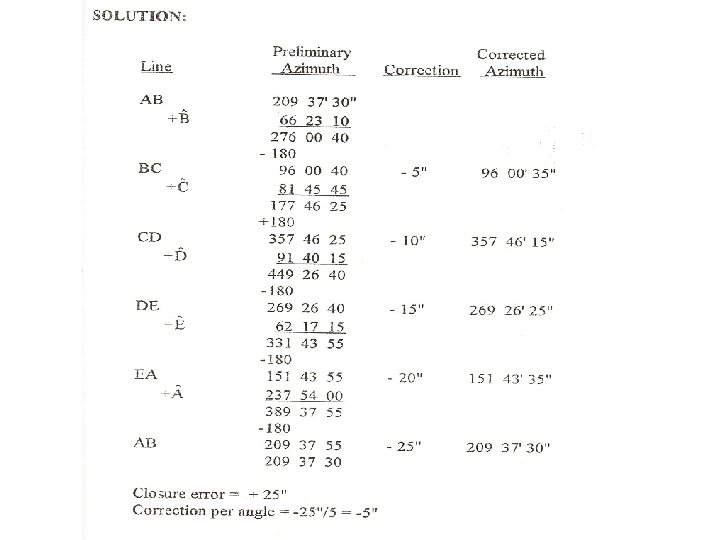
B- Checks and correction of errors: X last point – X first point = ∑ ∆ X all lines Y last point – Y first point = ∑ ∆ y all lines In order to meet the previous two conditions, the following corrections are performed: 1 - Angle correction: a- Closed loop traverse: For a closed traverse of n sides, sum of internal angles = (n – 2 ) × 180 º error = sum of measured angles – ((n – 2 ) × 180 º) correction = - error / no of internal angles b- For both loop and connecting closed traverse: If the azimuth of the last line in the traverse is known, then the error εα = αc (calculated azimuth) - αn (known azimuth) correction / angle = - εα / n the corrected azimuth αi = α’i ( initially computed azimuth)– i(εα / n)
2 - Position correction: IF the calculated and known coordinates of last point are: ( X c , Y c ) & ( X n , Y n )respectively, then Closure error in x-direction(ε x ) = X c – X n Closure error in y-direction(ε y ) = Y c – Y n Closure error in the position of the last points = √ ε x² + ε y ² Compass ( Bowditch ) Rule : used for position correction as follow: Correction to departure of side ij( ∆x) = -(length of side ij / total length of traverse)( ε x ) Correction to departure of side ij( ∆y) = -(length of side ij / total length of traverse)( ε y ) Correction can be done directly to coordinates: Cxi = - (Li / D) (ε x ) & Cyi = - (Li / D) (ε y ) Where: Li=the cumulative traverse distance up to station i &D=total length of the traverse The corrected coordinates of station i ( x'i , y'i ) are: X'i = Xi + Cxi & Y'i = Yi + Cyi Allowable error in Traverse surveying
the following figure:
Preliminary coordinates x x y y X Y
Corrected coordinates X-coordinate Final results Y-coordinate
X Y X Y
X X Y Y