Highresolution Nonhydrostatic Numerical Weather Prediction of Mediterranean torrential


- Slides: 17

High-resolution Non-hydrostatic Numerical Weather Prediction of Mediterranean torrential rain events Véronique DUCROCQ, Cindy LEBEAUPIN, Olivier NUISSIER, Didier RICARD, Hervé GIORDANI CNRM/GAME Météo-France & CNRS World Weather Research Program Symposium on Nowcasting and Very Short Range Forecasting, Toulouse, 5 -9 Sept. 2005

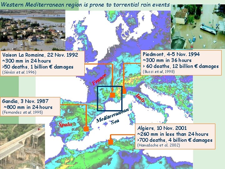
Western Mediterranean region is prone to torrential rain events Piedmont, 4 -5 Nov. 1994 ~300 mm in 36 hours > 60 deaths, 12 billion € damages Vaison La Romaine, 22 Nov. 1992 ~300 mm in 24 hours >50 deaths, 1 billion € damages (Sénési et al, 1996) n a Fr (Buzzi et al, 1998) ce Ita ly Gandia, 3 Nov. 1987 ~800 mm in 24 hours (Fernandez et al, 1995) Spain © Midi. Libre ean n a iterr d e M Sea Algiers, 10 Nov. 2001 ~260 mm in less than 24 hours >700 deaths, 4 billion € damages (Hamadache et al, 2002)

Western Mediterranean region is prone to torrential rain events Piedmont, 4 -5 Nov. 1994 ~300 mm in 36 hours > 60 deaths, 12 billion € damages Vaison La Romaine, 22 Nov. 1992 ~300 mm in 24 hours >50 deaths, 1 billion € damages (Sénési et al, 1996) n a Fr (Buzzi et al, 1998) ce Ita ly Gandia, 3 Nov. 1987 ~800 mm in 24 hours (Fernandez et al, 1995) Spain © Midi. Libre ean n a iterr d e M Sea Algiers, 10 Nov. 2001 ~260 mm in less than 24 hours >700 deaths, 4 billion € damages (Hamadache et al, 2002)

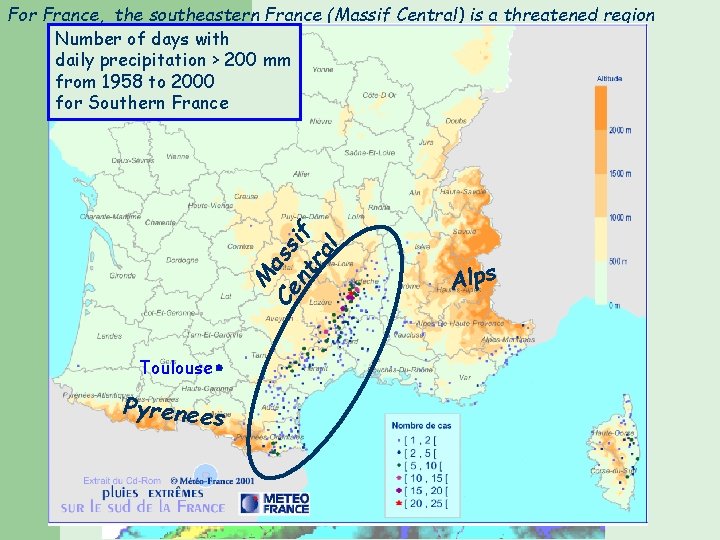
For France, the southeastern France (Massif Central) is a threatened region Number of days with daily precipitation > 200 mm from 1958 to 2000 for Southern France Piedmont, 4 -5 Nov. 1994 ~300 mm in 36 hours > 60 deaths, 12 billion € (Buzzi et al, 1998) M Ce ass nt if ra l e c an Fr Toulouse Spain Pyrenees an e n erra t i d Me Sea Ita Alps ly

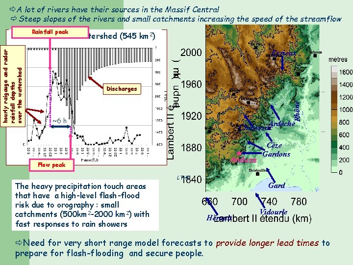
A lot of rivers have their sources in the Massif Central Steep slopes of the rivers and small catchments increasing the speed of the streamflow Rainfall peak Eyrieux Discharges Rhône hourly raigauge and radar rainfall depths over the watershed Gardon d’Anduze Watershed (545 km 2) ~6 h Ardèche Chassezac * Anduze Flow peak The heavy precipitation touch areas that have a high-level flash-flood risk due to orography : small catchments (500 km 2 -2000 km 2) with fast responses to rain showers LTHE Cèze Gardons Gard Hérault Vidourle Need for very short range model forecasts to provide longer lead times to prepare for flash-flooding and secure people.

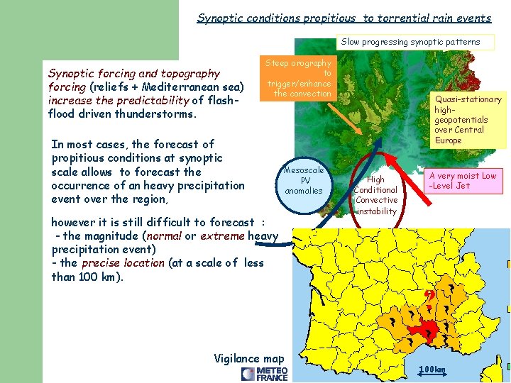
Synoptic conditions propitious to torrential rain events Slow progressing synoptic patterns Synoptic forcing and topography forcing (reliefs + Mediterranean sea) increase the predictability of flashflood driven thunderstorms. Steep orography to trigger/enhance the convection In most cases, the forecast of propitious conditions at synoptic scale allows to forecast the occurrence of an heavy precipitation event over the region, Mesoscale PV anomalies however it is still difficult to forecast : - the magnitude (normal or extreme heavy precipitation event) - the precise location (at a scale of less than 100 km). Quasi-stationary highgeopotentials over Central Europe High Conditional Convective instability A very moist Low -Level Jet ? Vigilance map 100 km

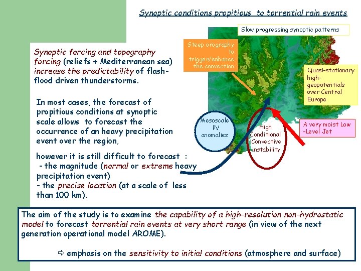
Synoptic conditions propitious to torrential rain events Slow progressing synoptic patterns Synoptic forcing and topography forcing (reliefs + Mediterranean sea) increase the predictability of flashflood driven thunderstorms. Steep orography to trigger/enhance the convection In most cases, the forecast of propitious conditions at synoptic scale allows to forecast the occurrence of an heavy precipitation event over the region, however it is still difficult to forecast : - the magnitude (normal or extreme heavy precipitation event) - the precise location (at a scale of less than 100 km). Mesoscale PV anomalies Quasi-stationary highgeopotentials over Central Europe High Conditional Convective instability A very moist Low -Level Jet The aim of the study is to examine the capability of a high-resolution non-hydrostatic model to forecast torrential rain events at very short range (in view of the next generation operational model AROME). emphasis on the sensitivity to initial conditions (atmosphere and surface)

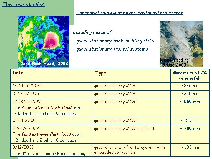
The case studies Torrential rain events over Southeastern France including cases of - quasi-stationary back-building MCS - quasi-stationary frontal systems Rhône flooding 3 Dec. 2003 Gard flash-flood, 2002 Date Type Maximum of 24 -h rainfall 13 -14/10/1995 quasi-stationary MCS ~ 250 mm 3 -4 /10/1995 quasi-stationary MCS ~ 200 mm 12 -13/11/1999 The Aude extreme flash-flood event ~30 deaths, 3 millions € damages quasi-stationary MCS ~ 550 mm 6 -7/10/2001 quasi-stationary MCS ~350 mm 8 -9/09/2002 The Gard extreme flash-flood event ~20 deaths, 1. 2 billion € damages quasi-stationary MCS and front ~ 700 mm 3/12/2003 The 3 rd day of a major Rhône flooding quasi-stationary frontal system with embedded convection ~ 180 mm

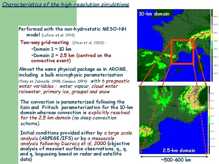
Characteristics of the high-resolution simulations 10 -km domain Performed with the non-hydrostatic MESO-NH model (Lafore et al, 1998) Two-way grid-nesting (Stein et al, 2000) : • Domain 1 ~ 10 km • Domain 2 ~ 2. 5 km (centred on the convective event) Almost the same physical package as in AROME, including a bulk microphysic parameterization (Pinty et Jabouille, 1998, Caniaux, 1994) with 6 prognostic water variables : water vapour, cloud water rainwater, primary ice, graupel and snow The convection is parameterized following the Kain and Fritsch parameterization for the 10 -km domain whereas convection is explicitly resolved for the 2. 5 km domain (no deep convection scheme). Initial conditions provided either by a large scale analysis (ARPEGE/IFS) or by a mesoscale analysis following Ducrocq et al, 2000 (objective analysis of mesonet surface observations, qv, qr and qs bogussing based on radar and satellite data) 2. 5 -km domain ~500 -600 km

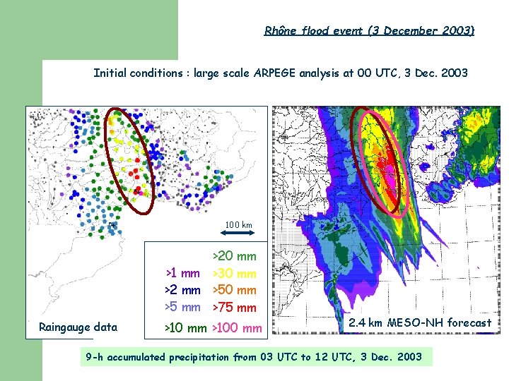
Rhône flood event (3 December 2003) Initial conditions : large scale ARPEGE analysis at 00 UTC, 3 Dec. 2003 100 km >20 mm >1 mm >30 mm >2 mm >50 mm >5 mm >75 mm Raingauge data >10 mm >100 mm 2. 4 km MESO-NH forecast 9 -h accumulated precipitation from 03 UTC to 12 UTC, 3 Dec. 2003

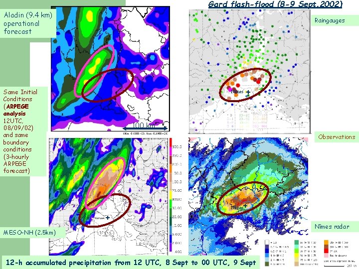
Gard flash-flood (8 -9 Sept. 2002) Aladin (9. 4 km) operational forecast Raingauges Same Initial Conditions (ARPEGE analysis 12 UTC, 08/09/02) and same boundary conditions (3 -hourly ARPEGE forecast) Nîmes + 100 km Observations + Nîmes + MESO-NH (2. 5 km) 12 -h accumulated precipitation from 12 UTC, 8 Sept to 00 UTC, 9 Sept 2002 Nîmes radar

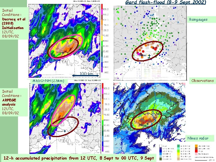
Gard flash-flood (8 -9 Sept. 2002) Initial Conditions : Ducrocq et al (2000) Initialisation 12 UTC, 08/09/02 Raingauges + Nîmes + 100 km MESO-NH (2. 5 km) Observations Initial Conditions : ARPEGE analysis 12 UTC, 08/09/02 + Nîmes radar 12 -h accumulated precipitation from 12 UTC, 8 Sept to 00 UTC, 9 Sept 2002

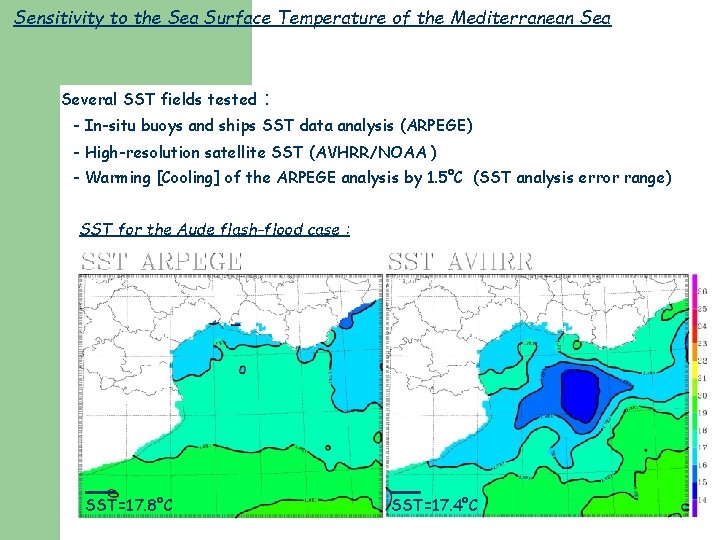
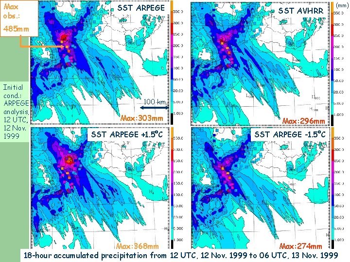
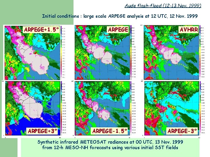
Sensitivity to the Sea Surface Temperature of the Mediterranean Sea Several SST fields tested : - In-situ buoys and ships SST data analysis (ARPEGE) - High-resolution satellite SST (AVHRR/NOAA ) - Warming [Cooling] of the ARPEGE analysis by 1. 5°C (SST analysis error range) SST for the Aude flash-flood case : SST=17. 8°C SST=17. 4°C

Max obs. : SST ARPEGE SST AVHRR (mm) 485 mm Initial cond. : ARPEGE analysis, 12 UTC, 12 Nov. 1999 100 km Max: 303 mm Max: 296 mm SST ARPEGE +1. 5°C SST ARPEGE -1. 5°C Max: 368 mm Max: 274 mm 18 -hour accumulated precipitation from 12 UTC, 12 Nov. 1999 to 06 UTC, 13 Nov. 1999

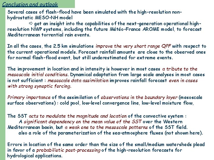
Conclusion and outlook Several cases of flash-flood have been simulated with the high-resolution nonhydrostatic MESO-NH model get an insight into the capabilities of the next-generation operational highresolution NWP systems, including the future Météo-France AROME model, to forecast Mediterranean torrential rain events. In all the cases, the 2. 5 km simulations improve the very short range QPF with respect to the current operational models. Forecast rainfall amounts are close to the observed ones for normal flash-flood event, but still underestimated for extreme events. The improvement in location and in intensity is however in most cases a tribute to the mesoscale initial conditions. Dynamical adaptation from large scale analyses in most cases is not sufficient : mesoscale data assimilation improves rainfall forecast even in cases with strong synoptic forcing. Primary importance of the assimilation of observations in the boundary layer (mesoscale surface observations) : cold pool, low-level convergence line, low-level moisture flow, The SST acts to modulate the magnitude and location of the convective system : A significant dependency on the mean value of the SST over the Western Mediterranean basin, but a weak one to the mesoscale patterns of the SST field. also a role of the parameterization of the sea-atmosphere fluxes (not shown here). Errors in location of the same order than the size of the small/medium watersheds plead in favor of a probabilistic post-processing of the high-resolution forecasts for hydrological applications.

Thank you for your attention

Aude flash-flood (12 -13 Nov. 1999) Initial conditions : large scale ARPEGE analysis at 12 UTC, 12 Nov. 1999 ARPEGE+1. 5° ARPEGE+3° ARPEGE AVHRR ARPEGE-1. 5° ARPEGE-3° Synthetic infrared METEOSAT radiances at 00 UTC, 13 Nov. 1999 from 12 -h MESO-NH forecasts using various initial SST fields