Hays Trinity Groundwater Conservation District HTGCD Mission Statement


 + (science) = groundwater availability desired future conditions managed available groundwater")

 DFC Modeling Results 3411 ac-ft Exempt Wells • Residential")

- Slides: 29
Hays Trinity Groundwater Conservation District
HTGCD Mission Statement “Given the critical importance of water to life and of that part of the water cycle called groundwater to local families, agriculture, commerce, stream flows and wildlife habitat, the Hays Trinity Groundwater Conservation District works to conserve, preserve, recharge and prevent waste of groundwater within western Hays County. To help accomplish these goals the District is charged to gather information needed for sound decisions, to provide that information to citizens and local agencies, and to insure that groundwater is used efficiently and at sustainable rates. ”
Texas Priority Groundwater Management Areas n n n 1991 - Hays Trinity became part of Hill County PGMA 2001 – HTGCD created by 77 th Legislature (S. B. 2) 2003 – HTGCD confirmed 2: 1 in popular election
Water Administration: Texas Water Code n Chapter 36. 0015 says: “Groundwater Conservation Districts created as provided by this chapter are the state’s preferred method of groundwater management. ”
Some Function of GCDs n n Provide for local control of GW resources in lieu of Rule of Capture (the right to pump all the GW you can with no consideration for the impact to other property owners or the eco-systems); Establish GW resource management policy for jurisdiction; Establish GW rights and issue production permits GCDs are accountable to electorate;
Single Member Districts w/in HTGCD
Summary of What the District Does Not Regulate n n Single Household Wells- must register but not permitted or metered by the District; No inspection of single household wells without permission; Wells used for conventional farming and ranching activities including such intensive operations as aquiculture, feedlots or poultry operations; Wells used for the dewatering and monitoring of lignite production and oil & gas
There are over 6, 650 wells in the District; District regulates less than 2%. (Exempt single family residential wells and agricultural wells may be drilled on any spacing and take water from permitted well owners and other exempt well owners)
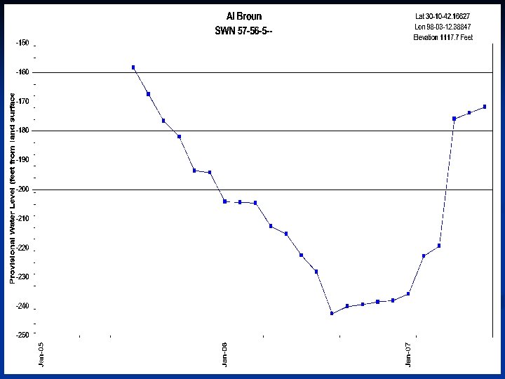
Al Broun, P. G. District Geologist
Management Plan Goal: Maximize Development of the Trinity Aquifer and Maintain Sufficient Water in the Aquifer to Maintain 90% of Stream Leakage During A Repeat of Drought of Record.
Stratigraphy
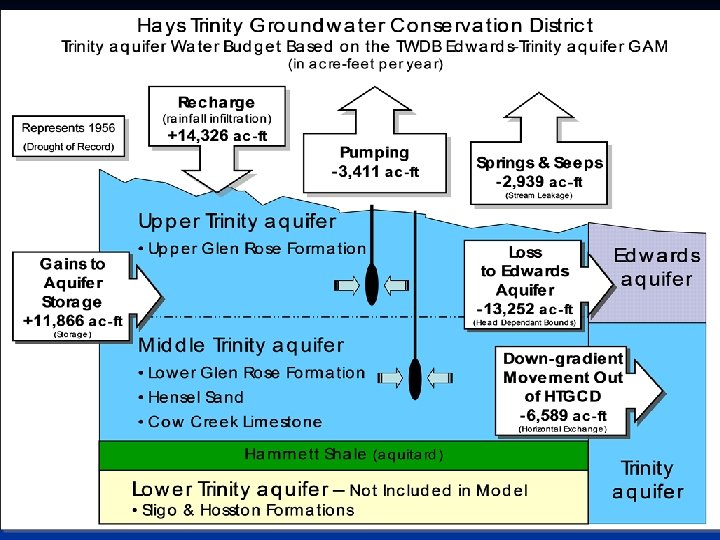
Hays Trinity Groundwater Conservation District Trinity aquifer Water Budget Based on the TWDB Edwards-Trinity aquifer GAM (in acre-feet per year) Recharge (rainfall infiltration) Pumping Springs & Seeps (Stream Leakage) Upper Trinity aquifer • Upper Glen Rose Formation Gains to Aquifer Storage Loss to Edwards Aquifer Edwards aquifer (Head Dependant Bounds) (Storage) Middle Trinity aquifer • Lower Glen Rose Formation • Hensel Sand • Cow Creek Limestone Hammett Shale (aquitard) Lower Trinity aquifer – Not Included in Model n. Sligo & Hosston Formations Down-gradient Movement Out of HTGCD (Horizontal Exchange) Trinity aquifer
TWDB Estimate of Useable Groundwater Total = 3, 411 ac-ft per year Region K: 2, 500 ac-ft per year Region L: 911 ac-ft per year Basis of Estimates: § TWDB Hill Country Trinity Aquifer GAM, 2000 § TWDB State Water Plans for Region K & L [The GAM’s do not include the resources of the Lower Trinity (Sligo / Hoston)]
Geologi c Map & Control Points
Lower Glen Rose, Woodcreek
Groundwater Usage 2003 -2004 HTGCD 2003 HTGCD 2004 Region L 2003 Region K 2003 Region L 2004 Region K 2004 25. 45” 52. 68” Dripping Springs Water Supply Corporation 253 51 Wimberley Water Supply Corporation 664 564 Aqua. Texas/Woodcreek 591 558 Woodcreek Golf Course 192 72 Agricultural Usage 152 59 93 Other Water Supply Corporations 538 210 328 Residential, (5000 Exempt Wells) 1, 850 721 1, 129 4, 240 3, 785 2, 437 1, 803 2, 184 1, 601 283 110 173 Total less Lower Trinity 3, 957 3, 502 2, 327 1, 630 2, 074 1, 428 Available Water 3, 713 1, 213 2, 500 1213 2, 500 Surplus/Deficit (244) 211 (1114) 870 (861) 1, 072 Annual Rainfall (Austin)- Total (acre-feet) Lower Trinity n n n 253 51
Groundwater Usage 2003 -2006 Production in Acre-Feet HTGCD 2003 HTGCD 2004 HTGCD 2005 HTGCD 2006 Annual Rainfall (Austin)- 25. 45” 52. 68” 22. 33” 34. 70” Dripping Springs Water Supply Corporation (253) (51) (71) (193) Wimberley Water Supply Corporation (664) (564) (653) (693) Aqua. Texas/Woodcreek (591) (558) (666) (649) Woodcreek Golf Course (192) (72) (87) (113) Agricultural Usage (152) Other Water Supply Cos ‘ 03&’ 04 were estimated based on connections (538) (226) (376) (1, 850) (2, 032) [5, 500] (2, 139) [5, 787] (4, 240) (3, 785) (3, 986) (4, 315) 283 283 285 (3, 957) (3, 502) (3, 703) (4, 030) Available Water in Upper and Middle Trinity 3, 713 Surplus/Deficit in Upper and Middle Trinity (244) 211 10 (317) Residential (~5, 000 Exempt Wells) Total (acre-feet) Estimated Lower Trinity Usage n n n Total less Lower Trinity
groundwater management areas
What House Bill 1763 says n Regionalizes decisions n Districts over regions n Permitting target
(policy) + (science) = groundwater availability desired future conditions managed available groundwater
Districts in GMAs decide Desired Future Conditions and deliver to TWDB provides estimates of Managed Available Groundwater to districts and regions Districts and regions include Managed Available Groundwater in plans
Example MAG Allocation Scenario (2006) DFC Modeling Results 3411 ac-ft Exempt Wells • Residential (6650) 2560 • Agricultural 152 MAG for Permitting 699 Non-exempt Usage 2125 (1425 ac-ft) Wimberley Valley Non-exempt Usage 1500 ac-ft Requested Non-exempt Irrigation Usage 600 ac-ft
Hays Trinity Groundwater Conservation District