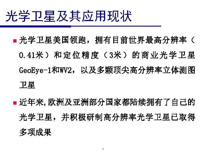
guozhangwhu edu cn zgsasmac cn 2 p m


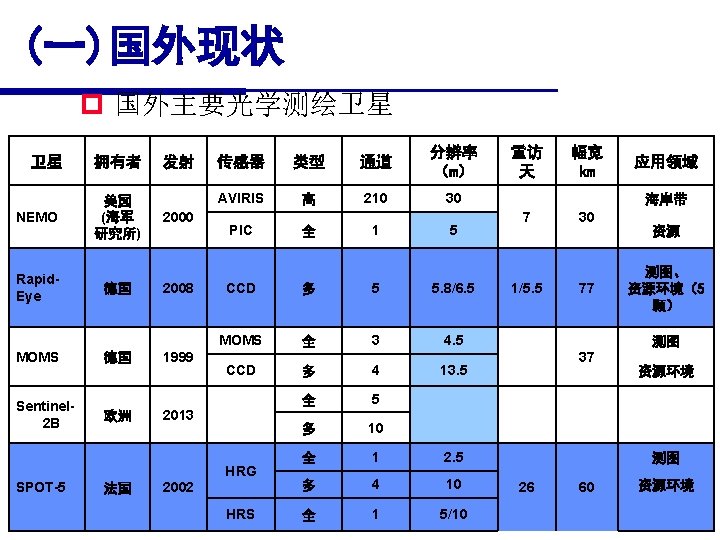
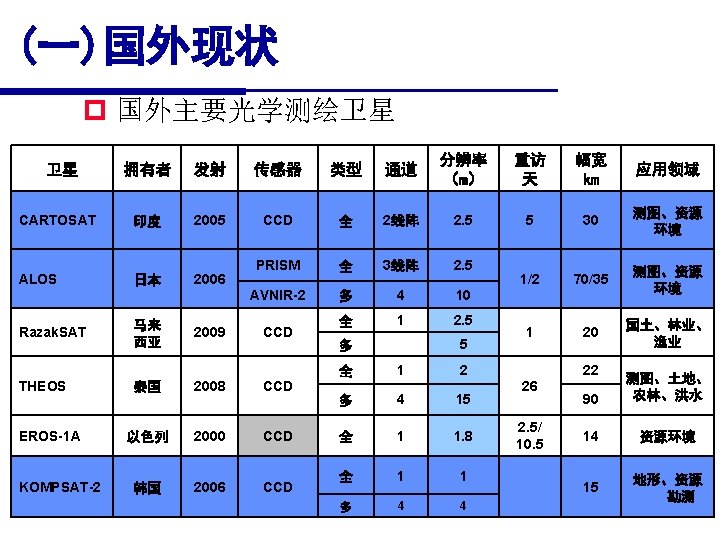
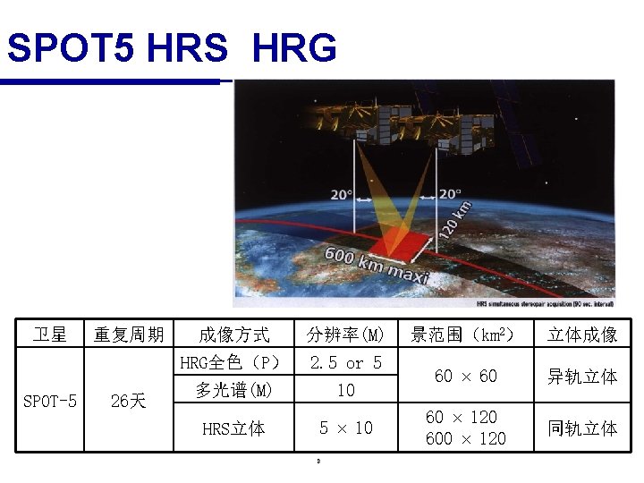
国外现状 p 国外主要光学测绘卫星 卫星 拥有者 发射 传感器 类型 通道 分辨率 (m) 重访 天 幅宽")


 and signal to noise ratio")


- Slides: 53
星载传感器国内外发展现状 张 过 guozhang@whu. edu. cn zg@sasmac. cn
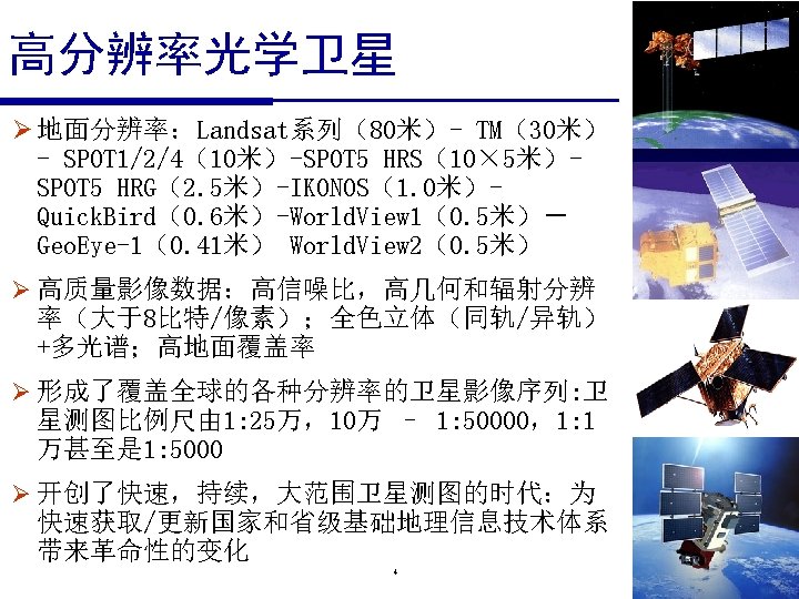
2
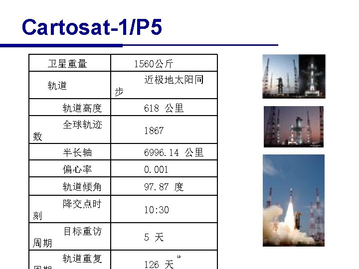
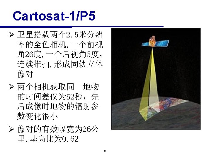
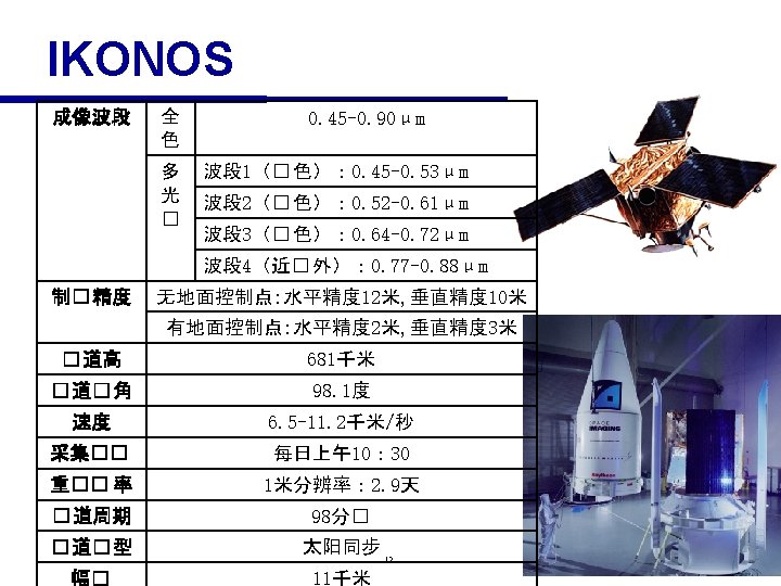
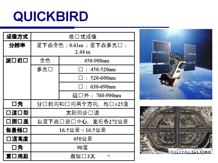
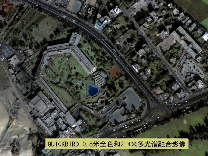
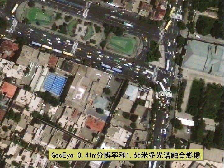
(一)国外现状 p 国外主要光学测绘卫星 卫星 拥有者 发射 传感器 类型 通道 分辨率 (m) 重访 天 幅宽 km 应用领域 全 1 1 2. 9 11 测图 多 4 4 1. 6 全 1 1 多 4 4 全 1 0. 61 多 4 2. 44 全 1 0. 46 美国 IKONOS-2 1999 IKONOS 2 2003 Orb. View-3 Geo. Eye Orb. View-3 美国 Geo. Eye Quick. Bird-2 美国 Digital Globe World. View 2 美国 Digital Globe 2008 美国 Geo. Eye 2008 Geo. Eye-1 Pleiades HR -1 A 1 B 2001 2010 法国 2011 Quick. Bird 2 World. View-2 多 8 1. 84 全 1 0. 41 多 CCD 7 4 1. 65 全 1 0. 7 多 4 2. 8 3 资源 环境 8 测图、资 源环境 测图 <6 16. 5 1. 1 /3. 7 16. 4 测图、海 洋、考古 3 15. 2 测图、资 源环境等 13 双星 20 资源环境 测图、 资源环境
北京SPOT 5 融合影像 2. 5 m. Pan+10 m. MS 9
World. View-1/2 n Highest resolution available commercially • 46 cm panchromatic at nadir • 52 cm out to 20° off-nadir n The most spectral diversity commercially available • 184 cm resolution at nadir • 4 standard colors: red, blue, green, near-IR • 4 additional colors: red edge, coastal, yellow, near-IR 2 n High geolocation accuracy • Ultra-stable platform, high-precision attitude sensors and GPS • Specification of 6. 5 m CE 90, with predicted performance in the range of 4. 6 to 10. 7 meters (15 to 35 feet) CE 90, excluding terrain and off-nadir effects • With registration to GCPs in image : 2. 0 meters (6. 6 feet) 15
World. View-1/2 n World-class telescope • High contrast (MTF) and signal to noise ratio • Selectable Time Delay Integration (TDI) levels, both panchromatic and mutlispectral bands • 11 -bit dynamic range n ORBIT • Altitude: 770 kilometers • Type: Sun synchronous, 10: 30 am descending node • Period: 100 minutes n Swath Width • 16. 4 kilometers at nadir 16
Worldview-1 0. 5米全色影像 17
World. View-1/2 All collections < 45 degrees off-nadir 18 4/12/10
19 1919
20 2020
21 2121
22 2222
23 2323
24 2424
25 2525
26 2626
27 2727
28 2828
29 2929
30 3030
31 3131
32 3232
33 3333
34 3434
35 3535
36 3636
37 3737
38 3838
39 3939
Geo. Eye n Spatial Resolution • Panchromatic Sensor 0. 41 meters x 0. 41 meters • Multispectral Sensor 1. 65 meters x 1. 65 meters n Spectral Range 450– 800 nm • • n n n 450– 510 nm (blue) 510– 580 nm (green) 655– 690 nm (red) 780– 920 nm (near IR) Swath Width 15. 2 km Dynamic Range 11 bits per pixel 无控制点定位精度 • 立体 CE 90: 4 m;LE 90: 6 m • 单片 CE 90: 5 m 40
SPOT 6 43
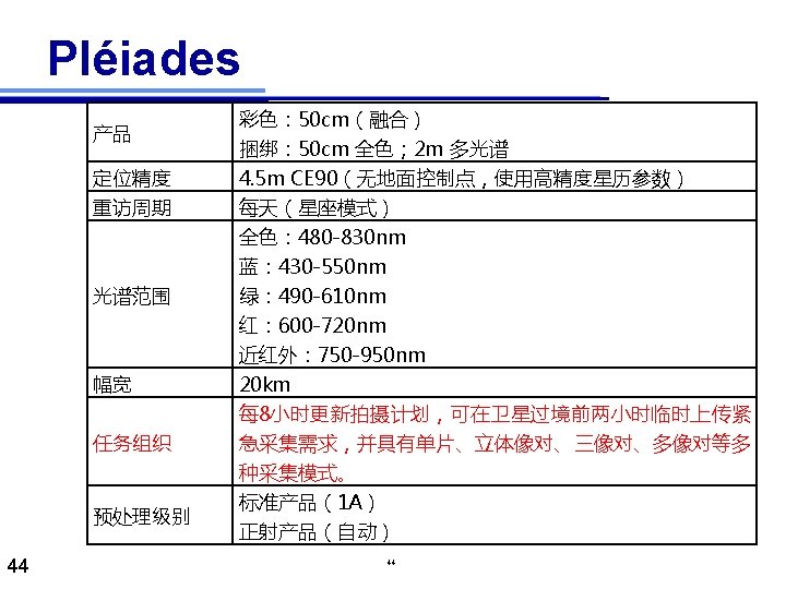
Pléiades 45
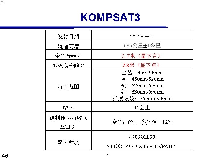
KOMPSAT 3 KOMPSAT-2、KOMPSAT-3影像对比 47 47
World. View-3 Launch Date Orbit August 13, 2014 Altitude: 617 km Type: Sun. Sync, 1: 30 pm descending Node Period: 97 min. Life Spec Mission Life; 7. 25 years Estimated Service Life: 10 to 12 years Spacecraft Size, Mass and Size: 5. 7 m (18. 7 feet) tall x 2. 5 m (8 feet) across, 7. 1 m (23 feet) across the deployed solar Power arrays Mass: 2800 kilograms (6200 pounds) Power: 3. 1 k. W solar array, 100 Ahr battery Sensor Bands Panchromatic: 450 -800 nm 8 Multispectral: (red, red edge, coastal, blue, green, yellow, near-IR 1 and near-IR 2) 400 nm - 1040 nm 8 SWIR: 1195 nm - 2365 nm 12 CAVIS Bands: (desert clouds, aerosol-1, aerosol-2, aerosol-3, green, water-1, water- 2, water-3, NDVI-SWIR, cirrus, snow) 405 nm - 2245 nm Sensor Resolution ( or GSD, Panchromatic Nadir: 0. 31 m GSD at Nadir 0. 34 m at 20° Off-Nadir Ground Sample Distance; off- Multispectral Nadir: 1. 24 m at Nadir, 1. 38 m at 20° Off-Nadir nadir is geometric mean) SWIR Nadir: 3. 70 m at Nadir, 4. 10 m at 20° Off-Nadir CAVIS Nadir: 30. 00 m Dynamic Range 11 -bits per pixel Pan and MS; 14 -bits per pixel SWIR Swath Width At nadir: 13. 1 km Attitude Determination and Type: 3 -axis stabilized Control Actuators: Control Moment Gyros (CMGs) Sensors: Star trackers, precision, IRU, GPS 48
World. View-3 Pointing Accuracy and Knowledge Accuracy: <500 m at image start and stop Knowledge: Supports geolocation accuracy below Retargeting Agility Time to slew 200 km: 12 seconds Onboard Storage 2199 Gb solid state with EDAC Communications Image & Ancillary: 800 & 1200 Mbps X-band Housekeeping: 4, 16, 32 or 64 kbps real-time, 524 kbps stored, X-band Command: 2 0 r 64 kbps S-band Max Contiguous Area Collected in a Single Pass (30° off-nadir Mono: 66. 5 km x 112 km (5 strips) angle) Stereo: 26. 6 km x 112 km (2 pairs) Revisit Frequency(at 40°N Latitude) 1 m GSD: <1. 0 day 4. 5 days at 20° off-nadir or less Geolocation Accuracy(CE 90) Predicted Performance: <3. 5 m CE 90 without ground control Capacity 680, 000 km 2 per day 49
worldview 3 50