Groundwater n Groundwater water that occupies pore spaces


 that")


 v Geologic • work of groundwater Groundwater is often")
 v Geologic • work of groundwater Caverns n Features")

 v Geologic • work of groundwater Karst topography n")


- Slides: 30
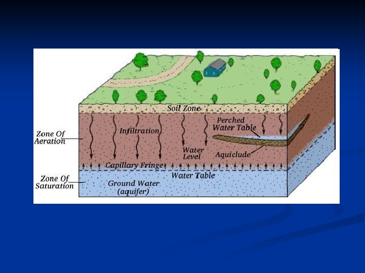
Groundwater n Groundwater: water that occupies pore spaces in sediment and rock in a zone beneath the Earth’s surface n n n Largest reservoir of fresh water available Produces caves and sinkholes Gravity is primary driving force Zone of Saturation: region where all the open spaces in sediment and rock are completely filled with water Water Table: upper limit of the zone of saturation Zone of Aeration: region above the water table
Groundwater Storage n Amount of water that can be stored depends on the porosity (the volume of open spaces) of a material. Well sorted alluvial deposits have high porosity. n Poorly sorted alluvial deposits have low porosity – the small particles take up the spaces between the large. n
Well-sorted = high porosity Poorly-sorted = low porosity
Groundwater Movement n Movement of groundwater depends on the permeability (ability to transmit fluid through interconnected pores). n n Fine texture = low permeability, slow movement Coarse texture = high permeability, fast movement http: //www. dmtcalaska. org/exploration/ISU/unit 5/u 5 lesson 1. html
Groundwater Movement Aquitards: regions of materials with very small pore spaces (like clay) that hinder groundwater movement n Aquifers: regions of materials with large pore spaces (like sand) that are highly permeable. A layer or zone under the surface capable of producing water to a well n
Groundwater Flow n Groundwater flows due to the force of gravity Hydraulic gradient defines the water table slope n Hydraulic head is the elevation of the water table at a given point n
Discharge n Groundwater are linked n Discharge and surface water occurs: lakes, streams, wetlands, springs n Artificial discharge=wells
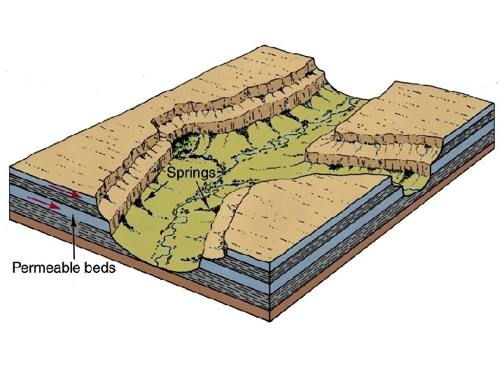
Springs: Natural Discharge n Springs=natural flow of water from the ground surface n n Intersection of water table-ground surface Springs caused by: Aquitards intersecting the ground surface n Faults cutting through aquifer n Fractures in volcanic rock n Road cuts n
Springs n Springs occur when the ground surface is below the water table – groundwater then flows on the surface. n Example: Thousand Springs in Idaho
Thermal Springs & Geysers n Hot and hot springs require: rock bodies to heat groundwater n Fractures system to transmit water n Large supply of groundwater n Geysers such as Old Faithful are the results of this process
Hot Springs and Geysers v Features • associated with groundwater Springs n Hot • springs Water is 6 -9ºC warmer than the mean air temperature of the locality Heated by cooling of igneous rock • 95% of US hot springs in the West • n Geysers • • Intermittent hot springs Water turns to steam and erupts Occur where extensive underground chambers exist within hot igneous rocks Ex. Old Faithful
Rachel Spring-Rotoura, New Zealand Temperature: 212°F
Old Faithful-Yellowstone National Park http: //www. youtube. com/watch? v=LWrkl. Fu. Ynb 0&feature=related
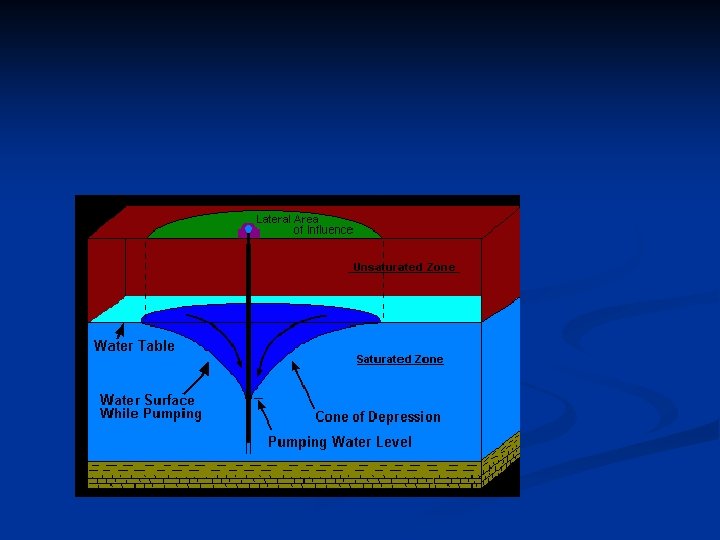
Wells n n Wells are drilled openings into the zone of saturation. Important freshwater source – 65% of wellwater is used for irrigation. Drawdown: lowering of the water table as water is taken from a well. Drawdown creates a cone of depression around the well (a local depression of the water table). n n Not noticeable around domestic wells. Problematic around industrial or irrigation wells – nearby shallow wells can dry up.
Wells
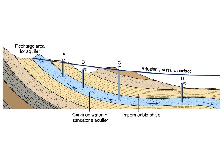
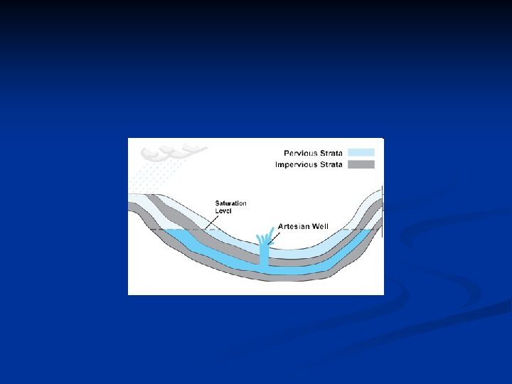
Artesian Wells Artesian Well: water rises above the level where it was tapped. n Can only occur when there is/are n An inclined aquifer where the higher side is exposed at the surface to receive water n Confining layers both above and below the aquifer keep it from moving anywhere except into the well. n
Water beneath the surface (groundwater) v Geologic • work of groundwater Groundwater is often mildly acidic n Contains weak carbonic acid n Dissolves calcite in limestone n Travertine is a form of limestone that is deposited by hot springs or as a cave deposit. • Caverns n Formed by dissolving rock beneath Earth's surface n Formed in the zone of saturation
Water beneath the surface (groundwater) v Geologic • work of groundwater Caverns n Features • • found within caverns Form in the zone of aeration Composed of dripstone Calcite deposited as dripping water evaporates Common features include stalactites (hanging from the ceiling) and stalagmites (growing upward from the floor)
Dripstone formations in Carlsbad Caverns National Park
Water beneath the surface (groundwater) v Geologic • work of groundwater Karst topography n Formed by dissolving rock at, or near, Earth's surface n Common features • Sinkholes – surface depressions • Sinkholes form by dissolving bedrock and cavern collapse • Caves and caverns n Area lacks good surface drainage
Formation of a Sinkhole
Development of karst topography
Environmental Problems with Groundwater n n n Overuse can threaten supply. Land subsidence: Groundwater removal can cause ground to sink (example: San Joaquin Valley dropped almost 9 meters between 1925 and 1975). Groundwater contamination from: n n Sewage Other sources
Groundwater Pollution n Types of groundwater pollution: Septic tank drainage n Agricultural chemicals n Industrial chemicals n Petroleum products n Landfills n
n Lets look at what’s happening with New Mexico Groundwater http: //www. earthworksaction. org/NM_GW_Contamination. cfm