GROUNDWATER Groundwater is water stored inside the Earths


, but others are very")

; the water in such")


- Slides: 30
GROUNDWATER Groundwater is water stored inside the Earth's soil and rock layers.
Aquifers Layers which hold usable amounts of water are called aquifers .
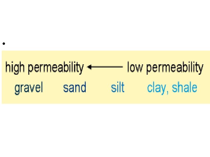
Porosity and Permeability Two important factors help determine how good an aquifer is: • 1. Porosity The percentage of the volume of a rock layer which is empty space (called pore space) and thus can hold water. Some rock layers are highly porous, with up to 40% of their volume made of pore space; others have low porosities of less than 1%. However, even in the least porous rock, there can be water. .
Porosity http: //www. dpiwe. tas. gov. au/inter. nsf/Images/LBUN-4 YJ 7 UA/$File/water_sedimentarylarge. jpg
Permeability • 2. Permeability More or less, how easy it is for water to flow through a rock layer. Permeability is partially controlled by porosity and partially by how the pores are connected and such. Essentially, the higher the porosity, the more water the rock layer can hold, and the higher the permeability, the easier it is to extract that water. Good aquifers will have high porosity and permeability.
Permeability http: //www. mhhe. com/earthsci/geology/mcconnell/images/anim_permeability. gif
Unsaturated VS Saturated • Typically, the pore space in the shallow soil beneath our feet is not full of water, but contains some air. This shallow part is called the unsaturated zone. Beneath the unsaturated zone, the pore space is full of water, and this zone is called the saturated zone.
• Groundwater begins as precipitation that is absorbed into the ground. A lot of it is taken up by plant roots and evapotranspired. What makes it beyond to root zone is pulled down by gravity until it reaches the water table. Below the water table all the pore space in the soil is filled with water. This is the saturated zone.
Groundwater Table • The boundary between the unsaturated and saturated zones is called the groundwater table or water table. Clearly, if you are going to drill a well for water, you want to get well below the water table into the saturated zone. • http: //geology. er. usgs. gov/eespteam/brass/ground/art/fig 10_6. gif
• Some layers are highly porous and permeable (aquifers), but others are very impermeable - water does not penetrate or flow through these layers, which are often made of clay or shale. These layers are called aquicludes or aquitards. http: //www. mme. state. va. us/Dmr/GALLERY/HISTORIC/clay/bwclay 20_2 a. html White residual clay pit southeast of Cold Spring, Augusta County.
Unconfined Aquifers • Some aquifers have an aquiclude beneath them but not above them; these are called unconfined aquifers and are easily filled with infiltrating rainwater.
Confined Aquifers • Other aquifers are sandwiched between aquicludes (confined); the water in such aquifers is often pressurized, and if a well is drilled into one, the well will flow freely with no pumping. Such wells are called artesian.
Recharge/Discharge • Recharge is adding water to an aquifer and discharge is removing water from an aquifer. If recharge exceeds discharge, the aquifer will slowly fill with water. If discharge exceeds recharge, the aquifer will slowly drain of water. http: //www. umaine. edu/Water. Research/outreach/images/gw 3_for_web. gif
Cone of Depression. • If you pump water from an aquifer at a rate which exceeds the rate of recharge, you will lower the water table near your well; this region of lowered water table is called a cone of depression. • If you pump water too quickly for too long, your well's cone of depression may deepen to the bottom of the well, and your well will run dry. You will either have to stop pumping and wait for recharge or drill a deeper well.
Cone of Depression http: //www. epa. state. il. us/water/groundwater/images/cone-of-depression. gif
SUBSIDENCE • Overpumping can cause • problems at the surface, as well. If you drain the water from an aquifer, the pore space may collapse, causing the material to shrink and the surface to become depressed. This surface depression is called subsidence, and is a major problem for some parts of the world.
SUBSIDENCE • In many areas of the arid Southwest, earth fissures are associated with land subsidence. Earth fissures can be more than 100 feet deep and several hundred feet in length. One extraordinary fissure in central Arizona is 10 miles long. These features start out as narrow cracks, an inch or less in width. They intercept surface drainage and can erode to widths of tens of feet at the surface.
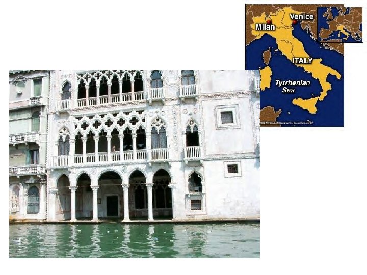
Sinking Venice • Venice is slowly subsiding into the northern Adriatic Sea because of over pumping of groundwater; Mexico City is sinking into the former lake bed on which it is built. In some areas of the world, the Earth's surface is subsiding at a rate of one foot per year as a result of over pumping.
Groundwater Contamination Clearly, if groundwater flows that slowly, anything which contaminates the water will be there for a long time. Among the sources for groundwater contamination are: • Leaking gasoline storage tanks A new law was recently put into effect requiring gas stations to upgrade from single-walled underground storage tanks to doublewalled tanks, to try to reduce gas leakage into groundwater. (This is why many gas stations have been either torn down or temporarily closed recently. ) http: //bcn. boulder. co. us/basin/waterworks/lust-anat 2. htm • Poorly-maintained septic tanks Oh, the stench of it all!
Groundwater Contamination • Unlined landfills If you dump trash and toxic materials into a landfill, gunk will eventually make its way into groundwater. However, if you build a clay or rubber liner under your landfill, you can slow or stop this process. • Agriculture Pesticides and other agricultural contaminants can enter groundwater over time.
Groundwater Contamination • Mining waste Often as mines were dug (and still are in some places), big piles of leftover rock and debris were left behind. Lots of heavy metals are present in these tailings, and rainwater can also leach acids out of them. Neither heavy metals nor acids are stuff I want in my drinking water.
Water and tin mining waste - a noxious mixture http: //news. bbc. co. uk/olmedia/320000/images/_322107_mine. jpg
Industrial Waste Superfund Sites / Toxic Waste Virginia’s 30 Superfund cleanup sites increase . the risk of soil, groundwater, and surface water contamination, especially in areas with multiple listings such as York County and the city of Portsmouth
Virginia • Water Quality Pollution and development have compromised the Old Dominion’s water sources: Virginia ranks sixth highest in the nation for amount of developmental toxins released into the state’s waters. The problems affect people as well as natural ecosystems: 81 percent of Virginia’s coastal waters and 30 percent of rivers, streams, and creeks are under fish consumption advisories due to chemical contamination, and half of the state’s 55 watersheds are at high risk for loss of wetland aquatic species.
Radioactive Waste • Radioactive waste We generate lots of high-level nuclear waste in bomb-making and reactors. While nuclear power is a good way to generate electricity, the waste must be dealt with. One proposal is to drill a series of giant tunnels and caverns into Yucca Mountain in the south/central Nevada desert and entomb the waste for 10, 000 years. Of course, you have to worry about the water table and contamination, and billions of dollars have been spent on this project. What will ultimately happen is still not clear.
Radioactive Waste • In USA high-level civil wastes all remain as spent fuel stored at the reactor sites. It is planned to encapsulate these fuel assemblies and dispose of them in an underground engineered repository about 2010, at Yucca Mountain, Nevada.
Summary • What you need to know: 1. What is an aquifer? 2. Define Porosity and Permeability. 3. What is the an unsaturated zone verses a saturated zone? 4. What is a groundwater table? 5. What is an aquicludes or aquitards? 6. Explain the differences between a confined aquifer and an unconfined aquifer. 7. What does recharge and discharge mean? 8. What is the Cone of Depression? 9. What is subsidence? And how does it occur? 10. Understand how contaminates can affect our water supply?
CITED • • • http: //pasadena. wr. usgs. gov/office/ganderson/es 10/lectures/lnotes. html http: //www. internationalwaterlaw. org/Articles/IGW-Models/Aquifers. jpg http: //www. dpiwe. tas. gov. au/inter. nsf/Images/LBUN 4 YJ 7 UA/$File/water_sedimentarylarge. jpg http: //geochange. er. usgs. gov/sw/changes/anthropogenic/subside/ http: //kylereed. com/Pictures/Foreign. Travel/Europe 2/Venice. Sinking. jpg http: //www. orcbs. msu. edu/environ/programs_guidelines/wellhead/glossary_faq /where_groundwater_comes_from. htm • http: //www. mhhe. com/earthsci/geology/mcconnell/images/anim_permeability. gif • • http: //www. mhhe. com/earthsci/geology/mcconnell/demo/prop. htm http: //geology. er. usgs. gov/eespteam/brass/ground/art/fig 10_6. gif http: //www. mme. state. va. us/Dmr/GALLERY/HISTORIC/clay/bwclay 20_2 a. html http: //www. sepa. org. uk/groundwater/images/confined-unconfined-aquifer. gif http: //www. umaine. edu/Water. Research/outreach/images/gw 3_for_web. gif http: //www. epa. state. il. us/water/groundwater/images/cone-of-depression. gif http: //www. nicholas. duke. edu/crossroads/virginia. html http: //news. bbc. co. uk/olmedia/320000/images/_322107_mine. jpg