Groundwater and Karst Topography Chapter 9 Section 2

")


- Slides: 63
Groundwater and Karst Topography Chapter 9, Section 2
The Hydrologic Cycle (WATER CYCLE)
Condensation Evaporation Precipitation Runoff
Groundwater Ø Soil is made up of many small rock and mineral fragments. Ø Holes, cracks, and crevices exist in the rock underlying the soil. Ø Water that soaks into the ground and collects in these pores and empty spaces become part of groundwater.
Ø Water is recharged to the ground-water system by percolation of water from precipitation and then flows to the stream through the ground-water system.
Ø 14 % of all freshwater on Earth exists as groundwater, 30 times more water than is contained in all of Earth’s lakes and rivers. Ø Water that soaks into the ground becomes a part of the groundwater system.
Ø A groundwater system is similar to a river system. Ø Instead of having channels that connect different parts of a drainage basin, the groundwater system has connecting pores.
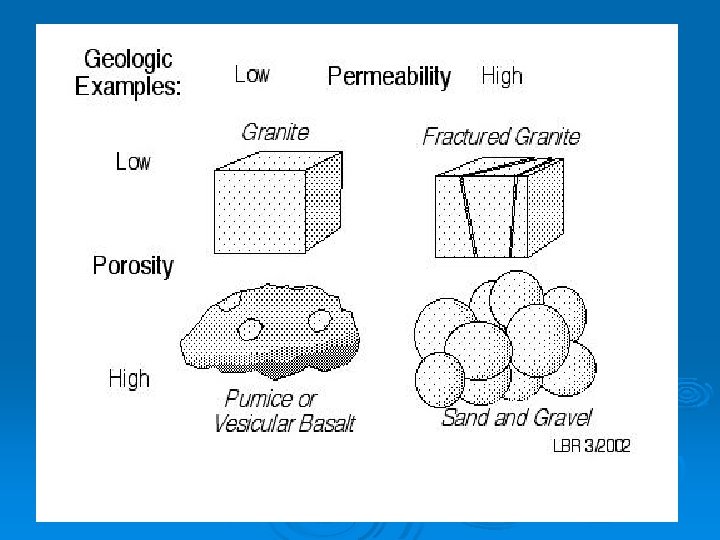
Ø Soil and rock are permeable if the pore spaces are connected and water can pass through them easily. Ø If a rock or sediment has few pore spaces, or they are not well connected, then the flow of groundwater is blocked. l These materials are impermeable, which means that water cannot pass through them. Ø Granite and clay are impermeable; sandstone is permeable.
Permeability
Ø Groundwater keeps going deeper into the Earth’s crust until it reaches a layer of impermeable rock. l l At this point, the water stops moving down. Water begins filling up the pores in the rocks above. The layer of permeable rock that lets water move freely is an aquifer.
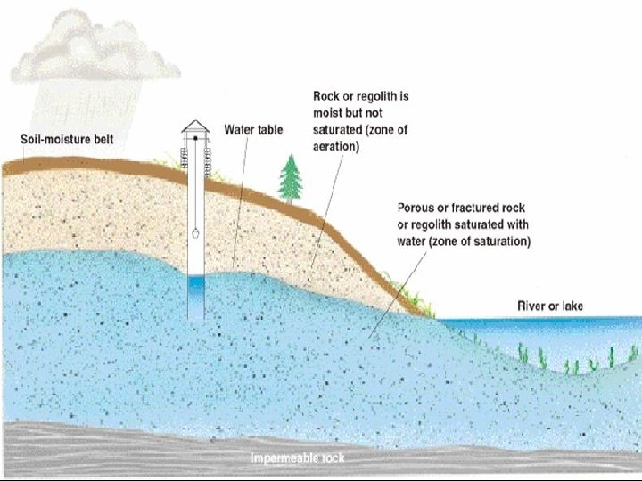
Ø The zone of aeration is the first layer of soil that is permeable. Water and air pass through this layer easily.
Ø The area where all of the rocks are filled with water is called the zone of saturation. Ø The upper surface of this zone is called the water table.
GROUNDWATER FEATURES
Groundwater Zones Zone of Saturation Ø Zone of Aeration Ø Precipitation Ø Body of water Ø Earth’s Surface Ø Water Table Ø
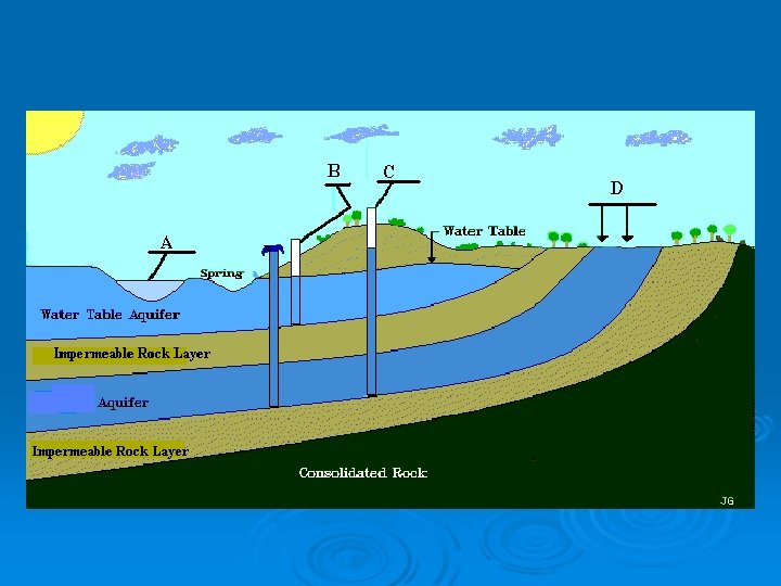
Ø Many people get their water from groundwater through wells that have been drilled into the zone of saturation. Ø The supply of groundwater is limited. During a drought the water table drops, which is why you should conserve water.
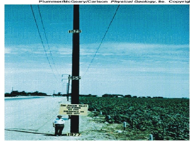
Ø People get the majority of their water from wells. A good well extends deep into the zone of saturation, where groundwater flows into the well and a pump brings it to the surface. If too much water is pumped out, then wells can go dry. l The land level can sink from the weight of the sediments above the now-empty pore spaces. l
What does a normal household well look like? Water flows into a well and then a pump brings the water to the surface. Ø Wells can go dry if too many are located in one area, or if a drought takes place. Ø
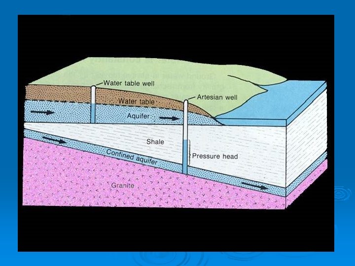
ARTESIAN WELL
Ø Water pumped from the ground-water system causes the water table to lower and alters the direction of ground-water movement. Some water that flowed to the stream no longer does so and some water may be drawn in from the stream into the ground-water system, thereby reducing the amount of streamflow.
CONES OF DEPRESSION
Shallow wells go dry due to excessive pumping
Ø In some places, the water table is so close to Earth’s surface that water flows out and forms a spring. l Springs are found on hillsides or other places where the water table meets a sloping surface.
SPRING FORMATION
HOT SPRINGS
Hot Spring
Ø A geyser is a hot spring that erupts periodically, shooting water and steam into the air. l Groundwater is heated to high temperatures from magma under the Earth’s surface. As the water heats, it expands, forcing water out of the ground along with steam, as the remaining water boils. Ø Old Faithful in Yellowstone National Park is a famous geyser.
GEYSERS: OLD FAITHFUL http: //www. yellowstone. net/russfinley/tour/video/oldfaith 2. rm
Picture of a geyser in action!
Geyser
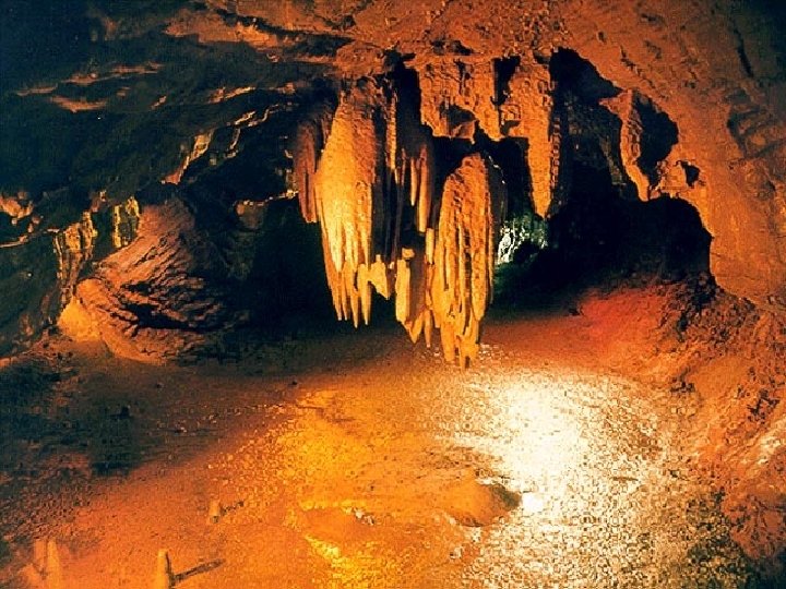
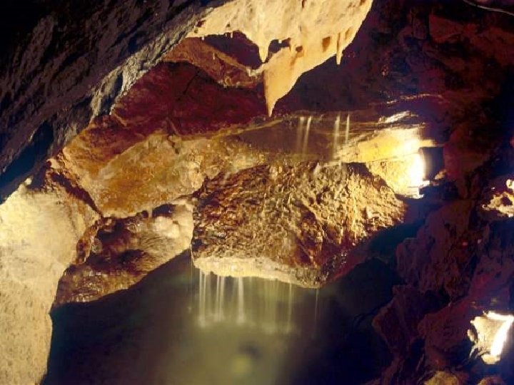
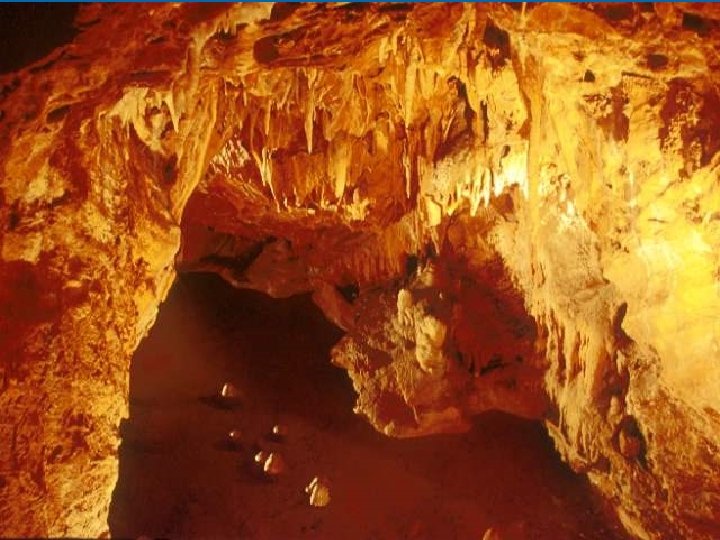
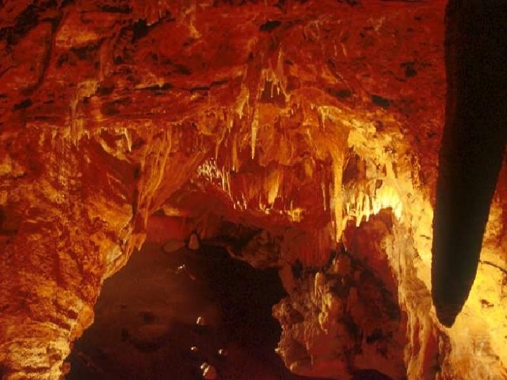
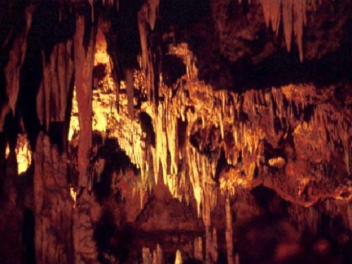
Ø Groundwater mixes with carbon dioxide to form carbonic acid. Ø Limestone is a rock that is easily dissolved by carbonic acid. Ø As the acidic groundwater moves through pores in limestone, the rock dissolves, enlarging cracks until an underground opening called a cave is formed.
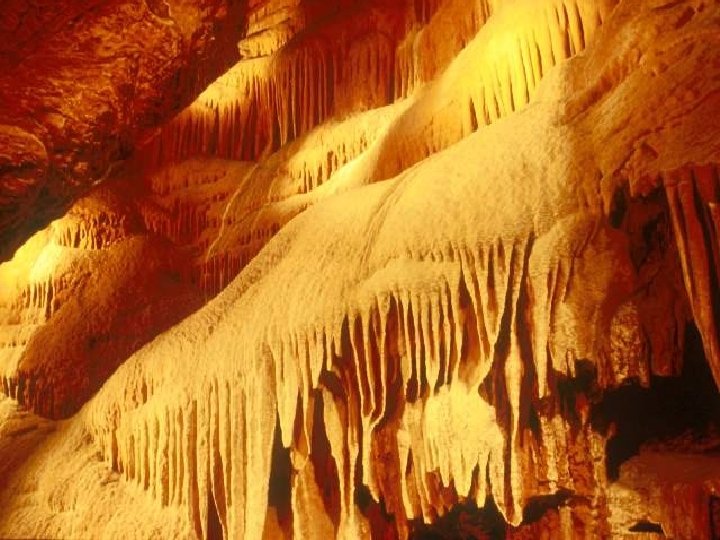
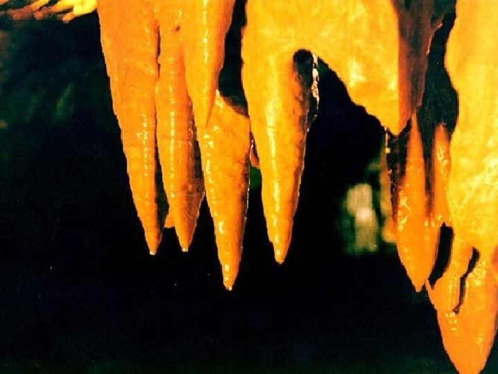
Ø Groundwater not only dissolves limestone to make caves, but it also can make deposits on the insides of caves. l l Water dripping from the cave walls contains calcium ions dissolved from the limestone. If the water evaporates while hanging from the ceiling, the calcium carbonate is left behind and builds up to form a stalactite. Where water drops fall to the floor, a stalagmite forms.
Cave Development
CAVE ENTRANCE
Disappearing Stream
NATURAL CHIMNEYS
NATURAL BRIDGE
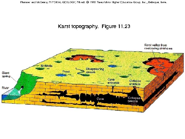
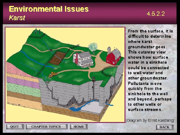
Ø If underground rock is dissolved near the surface a sinkhole may form. l l A sinkhole is a depression on the surface of the ground that forms when the roof of a cave collapses, or when rock near the surface dissolves. These are common in areas that have lots of limestone and enough rain water to keep the groundwater system supplied with water.
Sinkhole
SINKHOLE
Ø Karst topography is common in the Valley and Ridge Province of Virginia, where limestone is abundant.
KARST TOPOGRAPHY FEATURES
Human Impact on Groundwater accounts for 20% of all water used in the U. S. Ø Unwise use of this valuable resource can damage or deplete groundwater reservoirs Ø Some of the problems related to groundwater use include: Ø overpumping-lowering the water table Ø subsidence Ø contamination Ø
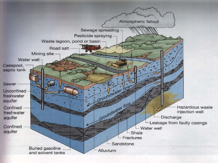
Pollutants Ø Contaminants introduced at the land surface may infiltrate to the water table and flow towards a point of discharge, either the well or the stream.
A SOURCE OF GROUNDWATER CONTAMINATION: SEPTIC TANKS
Contamination results in a decline in water quality.
ANOTHER SOURCE OF POLLUTION: STORAGE TANKS
YET ANOTHER SOURCE OF POLLUTION: LANDFILLS
Groundwater Moves – Usually Slowly