Green City Clean Waters Green Streets Complete Streets


- Slides: 32
Green City, Clean Waters Green Streets, Complete Streets Delaware Direct Partnership March 31, 2010
• $290 million to Restore and Preserve Stream Corridors • $320 million to Upgrade Water Pollution Control Plants • $1. 01 billion to ‘Green’ 34% of the combined sewer area by managing stormwater at the source For more information, visit www. phillywatersheds. org.
8 Green Programs Public Lands – Streets Saylor Grove Stormwater Wetland Philadelphia, PA – Schools – Public Facilities – Open Spaces Friends Center Green Roof Philadelphia, PA Springside School “Water Wall” and Rain Garden Philadelphia, PA Private Lands – Industrial/Commercial/Institutional – Homes – Parking – Alleys, Driveways and Walkways
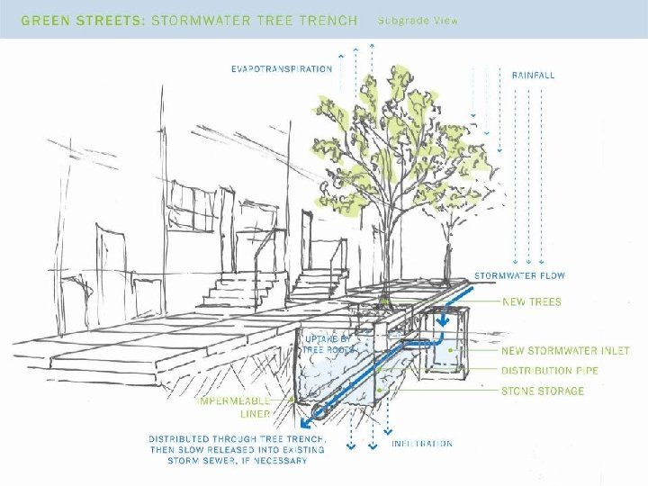
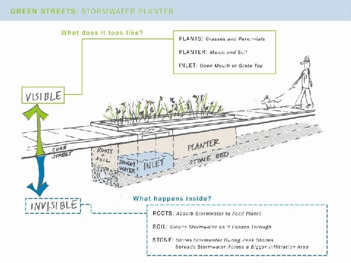
Green Stormwater Infrastructure § A range of soil-water-plant systems that intercept stormwater, infiltrate a portion of it into the ground, evaporate a portion of it into the air, and in some cases slowly release a portion of it back into the sewer system § Acknowledges the symbiotic relationship between land use and water resources
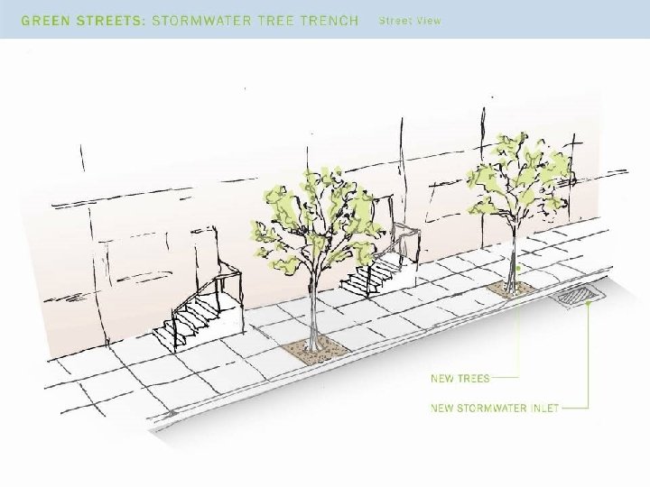
Green Stormwater Infrastructure Tools
What is a good green street? • • Minimal utility conflicts Few to no obstructions upslope of inlets No existing street trees upslope of inlets Wide sidewalks Building setback Relatively flat street Large drainage areas
Fewer Design / Implementation Challenges
More Design / Implementation Challenges
Site Selection Process • Identification • Investigation • Selection based upon: – Feasibility and cost-effectiveness – Neighborhood planning – Concurrent projects
Complete Streets Policy directive that streets and roads should provide for all transportation mode users. True Complete Streets require multiple partners and funding sources
Rhawn / Pennypack Princeton Unruh Levick Comly Bridge Buckius Orthodox Castor Allegheny / Delaware
Rhawn Street / Pennypack Street Cartway: 36 feet ROW: 50 -60 feet Rhawn Street looking east from rail station Pros: • Link Holmesburg Junction Station to Pennypack Park & East Coast Greenway Cons: • Some steep slopes • Limited ROW Intersection of Rhawn & State Rd.
Levick Street Cartway: 64 feet ROW: 80 feet Levick Street looking east from Tulip St. Pros: • Provide link to Lardner Point Park & East Coast Greenway • Right lane striped for no travel Cons: • Slopes • Traffic patterns create conflicts with pedestrians and bicyclists Levick at entrance to Tacony-Palmyra Bridge
Buckius Street Buckius looking east toward river at Bridesburg Rec Center Pros: • Adjacent to Bridesburg Rec Center Cons: • Riverside trail / park not yet created • Some separate / non-contributing areas Cartway: 32 feet ROW: 44 feet
E. Allegheny Ave. / N. Delaware Ave. Cartway: 60 -75 feet ROW: varies, max 122 feet Allegheny Ave. looking east from I-95 Pros: • Link Monkiewicz Playground, Pulaski Park, & East Coast Greenway • Project awarded TIGER funding Cons: • Potential conflicts with industrial uses • Some separate / non-contributing areas Corner of Allegheny & Delaware at Pulaski Park
Are we missing any priority connector streets? All of these streets present unique design and implementation challenges. Which should be our highest priority to move forward? · Rhawn / Pennypack · Levick · Buckius · Allegheny / Delaware
Ann Lehigh Cumberland Columbia Marlborough Shackamaxon Frankford Germantown / Laurel Brown Fairmount Spring Garden Callowhill
E. Columbia Avenue Cartway: 26 feet ROW: 50 feet Columbia looking east from Girard Pros: • Link Palmer Park, Hetzell Playground & Penn Treaty Park • Some projects already in design Cons: • Very limited ROW • Tree-lined in certain blocks Columbia looking east from I-95
Frankford Avenue Cartway: 36 feet ROW: 58 feet Frankford looking east from Girard Pros: • NKCDC streetscape project Cons: • Limited ROW • Some drainage areas are small Columbia looking east to intersection with Delaware Ave.
Germantown Avenue / Laurel Street Cartway: 30 -32 feet ROW: 50 -60 feet Germantown Ave. looking east Pros: • PWD Storm Flood Relief project in design Cons: • Limited ROW Laurel St. looking east toward Delaware Ave.
Spring Garden Street Cartway: 88 feet ROW: 120 feet Spring Garden St. looking east from 2 nd St. Pros: • Vision for Delaware to Schuylkill greenway connector Cons: • Many utility conflicts have been identified Spring Garden St. looking east from I-95
Are we missing any priority connector streets? All of these streets present unique design and implementation challenges. Which should be our highest priority to move forward? · Columbia · Frankford · Germantown / Laurel · Spring Garden
Race Washington Reed Tasker Snyder
Race Street Cartway: varies from 26 -46 ft ROW: varies, approx. 74 ft Race St. looking east from 2 nd St. Pros: • Connection to Race Street Pier Cons: • Traffic patterns create conflicts with pedestrians and bicyclists • Some separate / non-contributing areas Race St. at Columbus Blvd.
Washington Avenue Cartway: 120 -144 feet ROW: 142 -176 feet Washington Ave. looking east from 2 nd St. Pros: • Connection to Pier 53 • PWD Storm Flood Relief project in design Cons: • Some existing trees Washington Ave. at Columbus Blvd.
Tasker Street Cartway: 26 feet ROW: 52 feet Tasker St. looking east to Front St. Pros: • Direct connection from Pennsport to riverfront Cons: • Limited ROW • Small drainage areas Tasker St. at Columbus Blvd.
Snyder Avenue Cartway: 44 feet ROW: 74 feet Snyder Ave. looking east from 2 nd St. Pros: • Already striped for bike lanes • PWD Storm Flood Relief project in design Cons: • Multiple ownership / residential blocks • Some small drainage areas Snyder Ave. looking east from I-95
Are we missing any priority connector streets? All of these streets present unique design and implementation challenges. Which should be our highest priority to move forward? · Race · Washington · Tasker · Snyder
Green City Clean Waters