Gravity Geoid and Height Systems Lecture 08 Gravity


")


 of levelling")


")
 Ethiopia Geodetic Survey (1957 - 1961).")


 All lines are double")


 960 leveling bench marks 365 triangulation stations tied to 30 th")
- Slides: 30
Gravity, Geoid and Height Systems Lecture 08
Gravity, Geoid and Height Systems Problem of geometrical levelling GPS vs levelling Gravity, gravity potential, equipotential surface Theoretical misclosure of geometrical levelling Height systems Orthometric, normal vs dynamic heights Computational procedures of precise levelling Normal gravity field of the reference ellipsoid Definition. Normal gravity formula. Mean normal gravity Height reference systems and height networks Ethiopian Leveling
Height differences from levelling
GPS versus levelling
Gravitation of a point mass (M)
Gravitation of the earth’s masses
Gravitation, rotation and gravity
Equipotential surfaces and the geoid
Distance between two close equipotential surfaces
Theoretical misclosure (ε) of levelling
Height vs geopotential
Precise levelling
Height Systems
Concepts of Height Systems
Principle of Precise levelling
Principle of Precise levelling
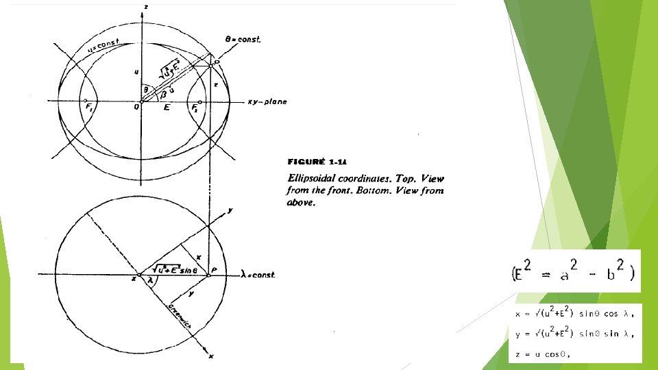
Normal Gravity Field of Reference Ellipsoid
Defining Constants of GRS 1930 and GRS 1980
Derived Constants of GRS 80
Normal Gravity Field of A Reference Ellipsoid
Vertical Datum in Ethiopia The height system in Ethiopia was established by the US Geodetic Survey starting from 1957 to 1961 for the Blue Nile River watershed project. The project covers west-central Ethiopia Further densification of control points was made from 1963 – 1971 to cover the whole Ethiopia
1957 -1961 Level Net (Blackwell, 1962)
Level net (1957 -1961) Ethiopia Geodetic Survey (1957 - 1961).
Vertical Datum in Ethiopia The Ethiopian vertical datum refers the mean sea level at Alexandria, Egypt. (Blackwell, 1962) The leveling work starts from a control point in Sudan (Gedarif) comes from Alexandria, Egypt carried through about 2800 km A level line run from Gedarif station to the Red Sea with closure error of 18 cm. (1282. 3 km) The mean sea level at Assab derived from a 12 -year series of tidal observation by the Italian Government
Vertical Datum in Ethiopia There is a large loops for the leveling work (Addis Zemen Kombolcha Addis Ababa Addis Zemen) The closure error of the large loop was 40 cm in 2112. 7 km The maximum rate of correction for long link (between Addis Zemen and Kombolcha) was 0. 26 mm/km
Leveling procedure Bench marks well established (Rock, metal, brass disk) All lines are double run Apply correction for the level data Systematic error Orthometric corrections based on theoretical values of gravity (due to non-parallelism of level surface) A least square adjustment of the level net
A kind of cross check A level run to Red Sea The Level data also compared with previous survey made along railway from Djibouti – Addis Ababa from 1912 to 1935.
Accuracy of the level work The final elevations obtained as the result of the least square adjustment are probably good within 3 meters except those station above 13 latitude. The elevation of these stations are good only 10 meters (Blackwell, 1962)
Result (1957 -1961) 960 leveling bench marks 365 triangulation stations tied to 30 th Meridian African Datum