Grade 12 GEOGRAPHY Examination preparation STRUCTURE OF PAPER


 What")


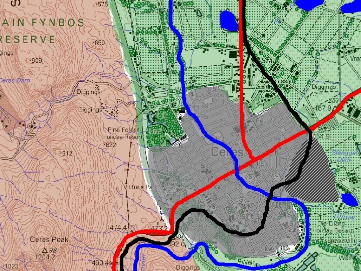

 in block H 7 is situated close to the CBD")


- Slides: 31
Grade 12 GEOGRAPHY Examination preparation
STRUCTURE OF PAPER 1 SECTION A Climate/Geomorphology QUESTION 1 QUESTION 2 SECTION B Settlement/ RSA Econ QUESTION 3 QUESTION 4 1. 1 Clim(7/8) 2. 1 Clim(7/8) 3. 1 Sett(7/8) 4. 1 Sett(7/8) 1. 2 Geo(7/8) 2. 2 Geo(7/8) 3. 2 Econ(7/8) 4. 2 Econ(7/8) 1. 3 Clim (15) 2. 3 Clim (15) 3. 3 Sett (15) 4. 3 Sett (15) 1. 4 Clim (15) 2. 4 Clim (15) 3. 4 Sett (15) 4. 4 Sett (15) 1. 5 Geo (15) 2. 5 Geo (15) 3. 5 Econ (15) 4. 5 Econ (15) 1. 6 Geo (15) 2. 6 Geo (15) 3. 6 Econ (15) 4. 6 Econ (15) • Answer THREE questions • Two paragraph-type questions in each of the four questions
Weighting of cognitive levels LOWER ORDER MIDDLE ORDER HIGHER ORDER Knowledge & Remembering 25% (75) • Name • Give • Define • Identify • Describe • Find • Match • List • Label Understanding & Applying 50% (150) • Discuss • Explain • Choose • Summarise • Show • Illustrate • Use • Describe • Apply Analysing, Evaluating Creating 25% (75) • Evaluate • Justify • Predict • Assess • Construct • Compose • Integrate • Rewrite • Argue
EXAMPLE OF A QUESTION 1. 6 Figure 1. 6 shows river erosion 1. 6. 1 What type of erosion is associated with rejuvenation? 1. 6. 2 What evidence indicates that rejuvenation has taken place? (1 x 1) (1) 1. 6. 3 Identify the force of upliftment associated with rejuvenation. (1 x 1) (1) 1. 6. 4 Why is rejuvenated land not suitable for human activity? (2 x 2) (4) 1. 6. 5 In a paragraph of approximately EIGHT lines, explain how rejuvenation could change the fluvial features downstream of the point of rejuvenation. `(4 x 2) (8) Questions become more difficult! (1 x 1) (1)
Two - Four mark questions: Short/one word These data- response type questions: Candidates questions where a discussion performed satisfactory in and detailed reference were the shorter questions. required, were often poorly answered. REPORT NB Command words PAPER 1 Paragraph-type Concepts: Most questions: These questions candidates do not have a sound were mostly of a mediumknowledge of the basic and higher order and had concepts. Not used well when been in most cases, answering questions competently to very poorly answered.
Short questions Study the 2018 question paper and write down the type of short questions found in the question paper • • • Choose correct answer in brackets Refer to diagram and choose Matching columns Choose one term from the list Multiple short questions Direct short questions
DATA RESPONSE QUESTIONS How can it be managed? What is it? What is the impact on the environment? Where Is it? What does it look like? Why is it there?
1. 2. 3. 4. 5. 6. EXAMINATION QUESTION Tropical cyclones Identify the type of cyclone at A. WHAT IS IT? Give the location of the cyclone, as shown on the map. WHERE IS IT? Why is the cyclone found there? WHY IS IT THERE? Draw a diagram to show the mature stage of the cyclone. WHAT DOES IT LOOK LIKE? Explain how the cyclone causes destruction. WHAT IS THE IMPACT ON THE ENVIRONMENT? (*NB PARAGRAPH) What can be done to limit the destruction caused by tropical cyclones to the minimum? HOW CAN IT BE MANAGED? (*NB PARAGRAPH)
EXAMINATION QUESTION Urban Settlement 1. 2. 3. 4. 5. Identify the land-use zone at A. WHAT IS IT? Is the zone of decay found at B or C ? Give TWO reasons for your answer. WHERE IS IT? Discuss the factors that influenced the location of the industries at D. WHY IS IT THERE? Discuss the characteristics of the buildings and types of functions found in the zone of decay. WHAT DOES IT LOOK LIKE? Identify the types and sources of pollution found in the city on the diagram. WHAT IS THE IMPACT ON THE ENVIRONMENT? (*NB PARAGRAPH) 6. What can be done to manage traffic jams in the city on the diagram? HOW CAN IT BE MANAGED? (*NB PARAGRAPH)
You have to study with these questions in mind LANDUSE ZONES - CBD What is it? Where is it? Why is it there? What does it look like? Impact on the environment? How can it be managed?
You have to study with these questions in mind RIVER CAPTURE (STREAM PIRACY) What is it? Where is it? Why is it there? What does it look like? Impact on the environment? How can it be managed?
PLEASE NB THE FOLLOWING QUESTIONS Discuss the HUMAN factors. . . Discuss the PHYSICAL factors…. . Discuss the ECONOMIC factors…. . Explain the HUMAN and PHYSICAL factors …. .
DATA HANDLING: • • Statistics Graphs Tables Infographics
CASE STUDIES, REPORTS, ETC • Read at least twice. • When part of infographic, integrate with other information. • Do not regard as comprehension test. • In many cases used to set the scene on which questions are based. • Do not quote form passage if not asked to. • Refer to facts in passage as basis for your answers.
Paragraph-type questions 2018 90 0 6 25 8 13 13 22 22 16 37 31 25 6 34 9 23 8 6 Q 3. 5. 4 Factors beef export Q 3. 3. 4 Protests service delivery Q 2. 5. 5 Changes rejuvenation Q 2. 4. 4 Dome cost of aintenanc e Q 1. 5. 4 Human Act Drainage Dens Q 1. 3. 5 9 18 53 13 2 9 8 17 19 12 Weather CF 0 4 5 18 30 10 10 11 8 50 20 18 8 Q 4. 4. 5 Q 4. 5. 4 Energy & labour copper 20 4 6 17 6 Water access rural areas 70 40 4 2 6 80 60 2
PARAGRAPH-PYPE QUESTIONS • Requires critical and analytical thinking Cannot merely reproduce knowledge gained in the classroom. • Responses should be well thought through and adapted to the source given. • Answer these questions in full sentences and to the point. • Limit your answers to the prescribed eight lines. • Many paragraph questions contain two components that must be referred to. • Underline the following: Ø the main topic of the question Ø the action word Ø the focus areas of the question.
INTERPRETING A PARAGRAPH-TYPE QUESTION A paragraph is made up of full sentences NB Length List and account the main characteristics Part 1 of your response Write a paragraph of approximately EIGHT lines to describe the human and environmental impacts of the mid latitude cyclone on agricultural activities. Part 2 of your response Negative or positive not stated could include both Specific to farming. (Crop and stock)
Write a paragraph of approximately EIGHT lines to describe the human and environmental impacts of the mid latitude cyclone on agricultural activities. RESPONSE Impact on Human activities Positive: - Provides rain for agriculture - Increases yield and income - Snow can be a tourist attraction Negative: NB Must mention at least ONE of both Human and Environment - Cold conditions and flooding can cause loss of life - Stock losses and damage to crops - Costly repairs and aid projects Impact on the environment Positive: - Rain sustains natural vegetation and animals Negative: - Flooding causes erosion and loss of topsoil - Eroded material slit up rivers and dams - Cold conditions can lead to vegetation damage (4 x 2) (8)
PRESCRIBED SUBJECT CONTENT For 2019 the following core industrial areas must be studied: • PWV/ Gauteng • Port Elizabeth-Uitenhage/Nelson Mandela Metropole. For 2019 the Saldanha Bay IDZ and case studies of the Platinum SDI and the Richards Bay SDI must be studied.
SECOND QUESTION PAPER Question 2 stio MCS n 1 Calculate Q Skills 4 n o i t s e Qu GIS 3 N O I T ES ATIO U Q C I L APP AND N ERINT TION A T E PR
QUESTION 1 – MULTIPLE CHOICE The general direction of flow of the Buffels River in Block J 5 is … A B C D Northeast Southwest • Attempt to answer ALL questions • Elimination • Guess
Calculations Distance QUESTION 2 Distance Area Gradient Map distance x Scale 100 000 Lxb VI (Height) HE (Distance) Answer in km² No units (1: 23) Answer in km Magnetic declination Mag N True N Magnetic Bearing Magnetic declination 3’ 5 23° + Bearing Vertical exaggeration Vertical scale Horizontal scale Answer = X Times
QUESTION 2 VI INT SI E B R IL IT Y 33° 22’ 18” S 18° 34’ 42” E GHT CO RD INA TES OO S HEI MAP SKILLS C SE RO C S TI S O N E W N IO CT NG RE RI DI EA B ON I T EC ER R I D RIV F O W FLO N P CE A M EN ER F RE Contours Trig. Stations Spot heights Bench marks
QUESTION 3 - INTERPRETATION elief BROWN rainage BLUE Contours far – Gradual Contours close - Steep Types of rivers Dams Sea RED BLACK nfra struct. Main roads Railway lines ettlements GREY Labour Market con. act GREEN BLACK Farms Industries
Parys is a popular holiday resort. Give ONE reason why Parys become a popular holiday destination Mountain? Flat? Close to sea, river? Accessibility Roads Railway What in and around settlement Farms wine tasting
Although West End (W) in block H 7 is situated close to the CBD it experiences much lower average temperatures than expected. Give and explain ONE reason for the statement above. Contours higher or lower? Close to sea, river? Building density Green belt? Farms cooler Industrial areas warmer
QUESTION 4 - GIS • • • CONCEPTS What is GIS? Remote sensing Spatial data Attribute data Buffering Resolution Data layers Data integration Vector data Raster data Data layers How to use GIS? (Scenario) Shops • • Available plots Costs of plots Distance to other shops Client base Client buying habits Central place Influence sphere Crime • • • Type Location Time Frequency Risk zones Neighbourhood characteristics
for your attention Good luck for the Geography examination