Gradation changes surface features of the land It


- Slides: 44
• Gradation changes surface features of the land. • It involves erosion, transportation and deposition. • It involves process like degradation, aggradations and weathering.
Agents of gradation
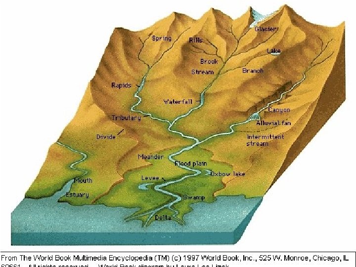
• Rivers originate from hills or mountains. • They have different amount of water In different seasons. • Some rivers water through out the year and some don’t.
• They are known as perennial and nonperennial rivers. • They are the most powerful agent of gradation. • The work of the running water is also called as fluvial process.
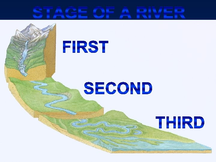
Rivers • It consists of three stages namely -
First stage • In the first stage the river has it maximum speed so most of the erosion is done in this course. • In the upper course of a river valley the land is highest, steepest and most exposed. • The weather in this part of the valley is colder, wetter, windier and more humid than the parts lower down
Niagara falls
Water falls • Waterfalls are caused by differences in rock hardness. • Waterfalls occur where the bed of a river becomes suddenly steepened.
waterfalls
Waterfalls
Victoria falls
Rapids
Rapids • A rapid is a section of a river where the river bed has a relatively steep gradient causing an increase in water velocity and turbulence. • Rapids occur where the bed material is highly resistant to the erosive power of the stream in comparison with the bed downstream of the rapids
Some examples for Rapids
Grand Canyon
Gorges
Gorges ØSome valleys have very steep sides and are both narrow and deep. ØA gorge often forms when waterfalls retreat up stream. Ø A gorge will also form when a river maintains its course across a belt of country which is being uplifted.
Swan gorges
Interlocking spurs • An interlocking spur is a natural geographical feature which occurs in a river's upper course • the interlocking spurs are foreshortened as the tips are sheared off. These are referred to as truncated spurs.
Interlocking spurs
Second stage • In the middle course the river's speed becomes slow that it was in the upper course. • The river deposits, erodes and as well as transports the eroded material. • The volume of water in the middle course is more that it was in the upper course.
Meanders
Meanders ØMeander is a loop-like bent in a river. ØAs a river nears the sea it winds up, forming regular horseshoe shape bends, these bends are called Meanders
Meanders
Meanders
Flood plains • Flood plain is a broad flat river valley in the lower reaches of a river. • A river often flows over wide plains of sediments or alluvium.
Flood plains
Ox-bow lake • Oxbow lake is a crescent - shaped lake on a river floodplain. • As the river wears away on the outside bend of the meander, the neck of the meander gets continually narrower.
Ox-bow lake
Third stage q. In the lower course of a river, the valley floor is extremely gently sloped. q. In this course the river generally deposits and very less erosion and transportation work takes place.
Distributaries
Distributaries • The distributaries branches off from the main river take the water away from the river. • They are a common feature of river deltas.
Distributaries
Delta ü Delta is a fan shaped low-lying area at a mouth. ü As a river enters the sea it suddenly slows down ü The word 'delta' has come from the Greek letter
Delta
Nile delta
Estuaries
Estuary v. Estuary is a river mouth broadening into the sea. v. Very fertile inlets called estuaries. v. E. g. , Klamath river.
Estuaries