GPS BASICS The Global Positioning System GPS is

GPS BASICS
 is a satellite-based navigation system made up of a")
The Global Positioning System (GPS) is a satellite-based navigation system made up of a network of 24 satellites placed into orbit by the U. S. department of Defense. Ø GPS was originally intended for military applications, but in the 1980 s, the government made the system available for civilian use. Ø GPS works in any weather conditions, anywhere in the world, 24 hours a day. ØThere are no subscription fees or setup charges to use GPS.
 u Developed by")
GPS Global Positioning System u Network of 24 satellites (with spares) u Developed by Department of Defense u Operational 24 hours/day u Available worldwide u Land, sea and air u Works in all weather conditions u It is FREE!! u

Satellite Constellation

Navigation Tools of the Past Sextant Chronometer

Beginnings TRANSIT developed by Navy in 1960 s u Used to track nuclear submarines u Air Force created own system u Used to locate vehicles on land or in air u

NAVSTAR u Combined Navy and Air Force systems in 1973 u NAVigation Satellite Timing And Ranging (NAVSTAR) u First used in combat during Operation Desert Storm – 1991 u Full Operational Capability – April 27, 1995

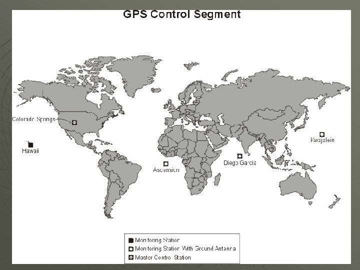
GPS System u u u Space Segment – Satellite Constellation Control Segment– Monitoring Stations and Ground Antennas User Segment – Receivers

GPS Satellite

Satellite Information u Weighs approximately 2, 000 lbs u Travels 7, 000 mph u 17 feet across with solar panels extended u Last 10 years u Orbit 12, 500 miles above Earth u Circle the Earth twice daily

In the next lesson we will learn: u How GPS works u Coordinates – Latitude and Longitude u Creating and Finding Waypoints using a GPS receiver

How Does GPS Work?

How it works u u Satellite circles the Earth and transmits signal Signal contains time it was sent and its location All satellites send their signal at the same time Difference in time to reach receivers is used to determine location

u u u Formula: Distance = Speed x Time Signal travels at the speed of light – 186, 282. 3976 miles per second Speed and Time are known, use to calculate Distance
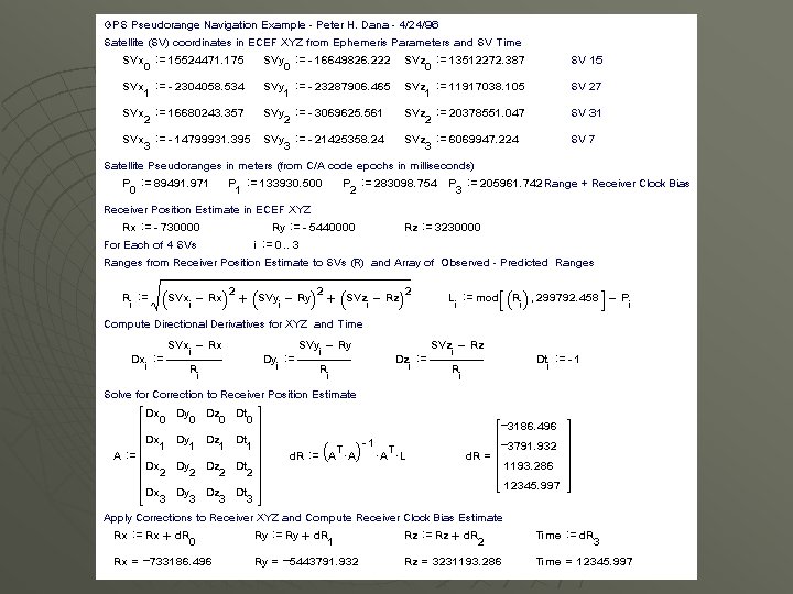

Trilateration u u u Process of measuring the distance from at least three satellites Three satellites calculate 2 D position (Latitude and Longitude) Four or more satellites calculate 3 D position (Latitude, Longitude, and Altitude)

Trilateration

One satellite can locate a receiver’s position somewhere on a sphere Two satellites can locate a receiver’s position to a circle representing the intersection of two spheres Three satellites can locate a receiver’s position to one of two points represented by the intersection of three spheres.

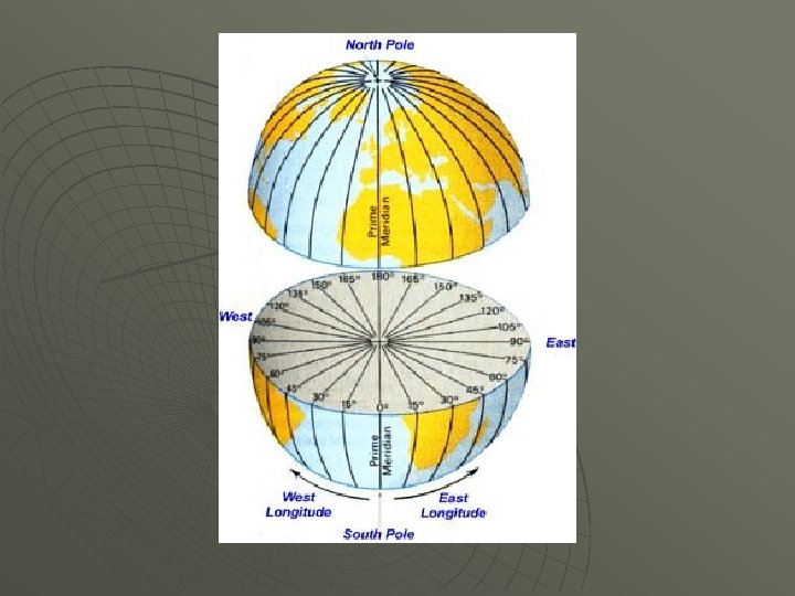
Latitude lines run horizontal u Equator is 0° u North and South Poles are 90° u

Lines of Latitude

Longitude Also known as meridians, run vertical u The Prime Meridian in Greenwich, England is 0° u Lines range from 0° to 180° u International Date Line is 180° u
 error (horizontal)")
Instantaneous positioning with GPS Accuracy of u +/- 10 m (30 ft) error (horizontal) u +/- 15 m (45 ft) error (vertical) Your location is: 37 o 23. 323’ N 122 o 02. 162’ W

Uses of GPS Locating Tracking Navigating Mapping Timing

Using GPS u What are uses you can think of? Boating Fishing Hunting Camping Hiking Biking Rafting

Using GPS continued u u Scouting from land or air, Horseback riding, Hot air ballooning, Aviation, Snowmobiling, Skiing, Search and Rescue, Four wheeling, Emergency Vehicle Tracking, Highway Driving Geocaching, Surveying, Military, Precision Agriculture

Using GPS continued u u u Survey disaster areas, Map movement of environmental disasters (Oil spills, wild fires, floods, etc) Mapping fallout shelters, sidewalks, streets, trees, trails, etc. Measuring the growth or decline of mountains

u How does GPS improve these activities? • Makes the location more precise • User Friendly • Mapping is easier • Universal system • Fun!

Multipath ‘echoes’ What can cause inaccurate measurements? u u Natural & Man-made barriers or reflectors can distort measurements If we were outside right now, what would cause potential multipath errors?
- Slides: 30