GPM Radar Observations and Simulations with the Local

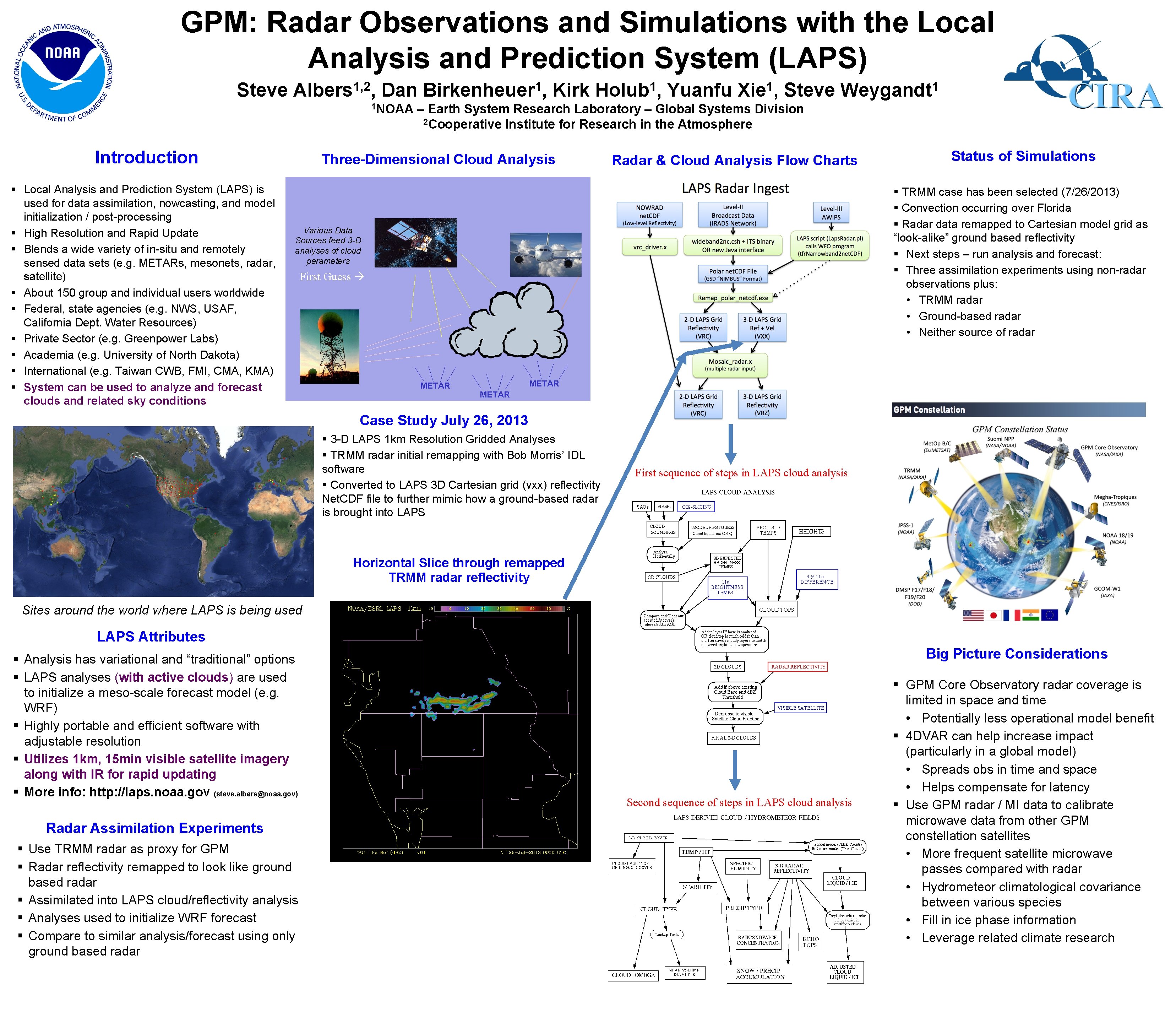
GPM: Radar Observations and Simulations with the Local Analysis and Prediction System (LAPS) Steve 1, 2 Albers , Dan 1 NOAA Introduction Local Analysis and Prediction System (LAPS) is used for data assimilation, nowcasting, and model initialization / post-processing High Resolution and Rapid Update Blends a wide variety of in-situ and remotely sensed data sets (e. g. METARs, mesonets, radar, satellite) About 150 group and individual users worldwide Federal, state agencies (e. g. NWS, USAF, California Dept. Water Resources) Private Sector (e. g. Greenpower Labs) Academia (e. g. University of North Dakota) International (e. g. Taiwan CWB, FMI, CMA, KMA) System can be used to analyze and forecast clouds and related sky conditions 1 Birkenheuer , Kirk 1 Holub , Yuanfu 1 Xie , Steve 1 Weygandt – Earth System Research Laboratory – Global Systems Division 2 Cooperative Institute for Research in the Atmosphere Three-Dimensional Cloud Analysis Radar & Cloud Analysis Flow Charts Status of Simulations TRMM case has been selected (7/26/2013) Convection occurring over Florida Radar data remapped to Cartesian model grid as “look-alike” ground based reflectivity Next steps – run analysis and forecast: Three assimilation experiments using non-radar observations plus: • TRMM radar • Ground-based radar • Neither source of radar Various Data Sources feed 3 -D analyses of cloud parameters First Guess METAR Case Study July 26, 2013 MADIS Global Solar Obs (<= 15 min, Defined in Metadata) 3 -D LAPS 1 km Resolution Gridded Analyses TRMM radar initial remapping with Bob Morris’ IDL software Converted to LAPS 3 D Cartesian grid (vxx) reflectivity Net. CDF file to further mimic how a ground-based radar is brought into LAPS First sequence of steps in LAPS cloud analysis Horizontal Slice through remapped TRMM radar reflectivity Sites around the world where LAPS is being used LAPS Attributes Analysis has variational and “traditional” options LAPS analyses (with active clouds) are used to initialize a meso-scale forecast model (e. g. WRF) Highly portable and efficient software with adjustable resolution Utilizes 1 km, 15 min visible satellite imagery along with IR for rapid updating More info: http: //laps. noaa. gov (steve. albers@noaa. gov) Big Picture Considerations Second sequence of steps in LAPS cloud analysis Radar Assimilation Experiments Use TRMM radar as proxy for GPM Radar reflectivity remapped to look like ground based radar Assimilated into LAPS cloud/reflectivity analysis Analyses used to initialize WRF forecast Compare to similar analysis/forecast using only ground based radarfor a little more Steve…Room text in this column Cloud Cover Analysis GPM Core Observatory radar coverage is limited in space and time • Potentially less operational model benefit 4 DVAR can help increase impact (particularly in a global model) • Spreads obs in time and space • Helps compensate for latency Use GPM radar / MI data to calibrate microwave data from other GPM constellation satellites • More frequent satellite microwave passes compared with radar • Hydrometeor climatological covariance between various species • Fill in ice phase information • Leverage related climate research
- Slides: 1