GOESR AWG Cloud Team Cloud and Moisture Imagery


- Slides: 25

GOES-R AWG Cloud Team: Cloud and Moisture Imagery June 8, 2010 Presented By: Tim Schmit 1 1 NOAA/NESDIS/STAR 1

Outline · · · · Executive Summary (1 slide) Algorithm Description (2 -4 slides) ADEB and IV&V Response Summary (1 -2 slides) Requirements Specification Evolution (2 slides) Validation Strategy (3 -5 slides) Validation Results (3 -5 slides) Summary (1 -2 slides) 2

Executive Summary · The purpose of the imagery team is two-fold: » Demonstrate how to convert from GRB scaled integers to other physical units, such as radiance, brightness temperatures and brightness values. » Build files that can be used for processing most all of the ABI products, such as clouds, soundings, etc. · Imagery is the key product for GOES-R. · The team has met the schedules (draft ATBD, CDR, TRR), mostly using simulated ABI data. · The products appear to be within spec. · Visualization examples progressing.

Algorithm Description 4

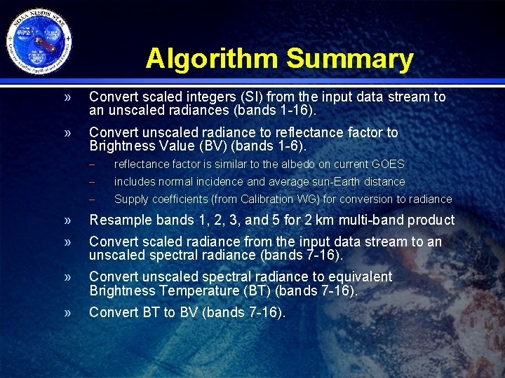
Algorithm Summary » Convert scaled integers (SI) from the input data stream to an unscaled radiances (bands 1 -16). » Convert unscaled radiance to reflectance factor to Brightness Value (BV) (bands 1 -6). – reflectance factor is similar to the albedo on current GOES – includes normal incidence and average sun-Earth distance – Supply coefficients (from Calibration WG) for conversion to radiance » Resample bands 1, 2, 3, and 5 for 2 km multi-band product » Convert scaled radiance from the input data stream to an unscaled spectral radiance (bands 7 -16). » Convert unscaled spectral radiance to equivalent Brightness Temperature (BT) (bands 7 -16). » Convert BT to BV (bands 7 -16).

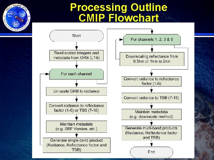
Processing Outline CMIP Flowchart

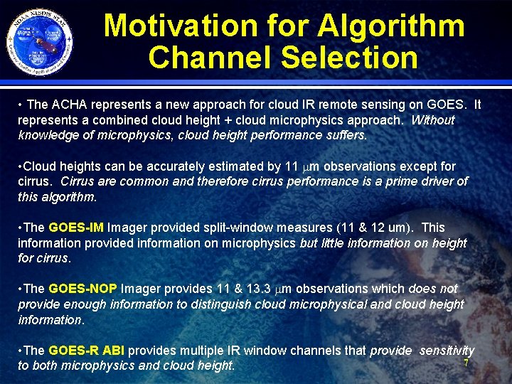
Motivation for Algorithm Channel Selection • The ACHA represents a new approach for cloud IR remote sensing on GOES. It represents a combined cloud height + cloud microphysics approach. Without knowledge of microphysics, cloud height performance suffers. • Cloud heights can be accurately estimated by 11 mm observations except for cirrus. Cirrus are common and therefore cirrus performance is a prime driver of this algorithm. • The GOES-IM Imager provided split-window measures (11 & 12 um). This information provided information on microphysics but little information on height for cirrus. • The GOES-NOP Imager provides 11 & 13. 3 mm observations which does not provide enough information to distinguish cloud microphysical and cloud height information. • The GOES-R ABI provides multiple IR window channels that provide sensitivity 7 to both microphysics and cloud height.

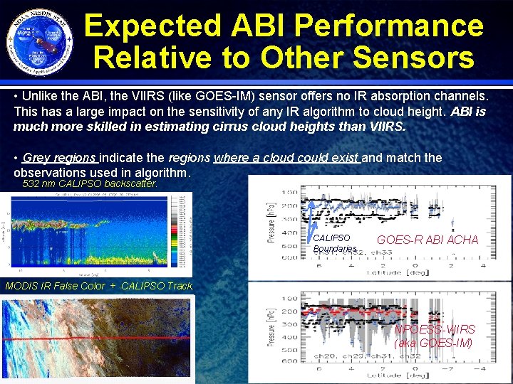
Expected ABI Performance Relative to Other Sensors • Unlike the ABI, the VIIRS (like GOES-IM) sensor offers no IR absorption channels. This has a large impact on the sensitivity of any IR algorithm to cloud height. ABI is much more skilled in estimating cirrus cloud heights than VIIRS. • Grey regions indicate the regions where a cloud could exist and match the observations used in algorithm. 532 nm CALIPSO backscatter. CALIPSO Boundaries GOES-R ABI ACHA MODIS IR False Color + CALIPSO Track. NPOESS-VIIRS (aka GOES-IM) 8

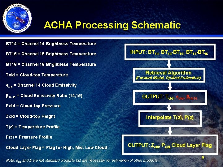
ACHA Processing Schematic BT 14 = Channel 14 Brightness Temperature BT 15 = Channel 15 Brightness Temperature INPUT: BT 14, BT 14 -BT 15, BT 14 -BT 16 = Channel 16 Brightness Temperature Tcld = Cloud-top Temperature Retrieval Algorithm (Forward Model, Optimal Estimation) ecld = Channel 14 Cloud Emissivity b 14, 15 = Cloud Emissivity Ratio (14, 15) OUTPUT: Tcld, ecld, b 14, 15 Pcld = Cloud-top Pressure Zcld = Cloud-top Height Interpolate T(z), P(z) T(z) = Temperature Profile P(z) = Pressure Profile Cloud Layer Flag = Flag for High, Mid, Low Cloud OUTPUT: Zcld, Pcld, Cloud Layer Flag Note, ecld and are not standard products but are necessary for estimation of other products. 9

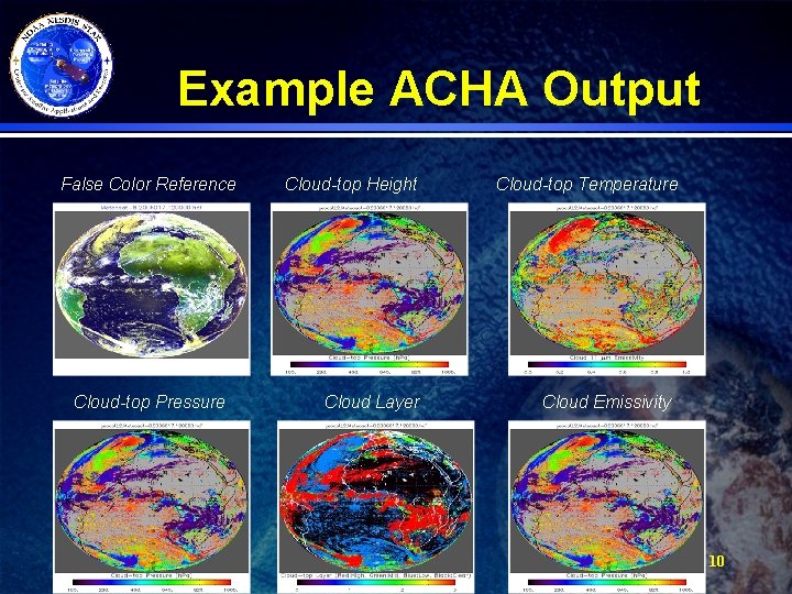
Example ACHA Output False Color Reference Cloud-top Pressure Cloud-top Height Cloud Layer Cloud-top Temperature Cloud Emissivity 10

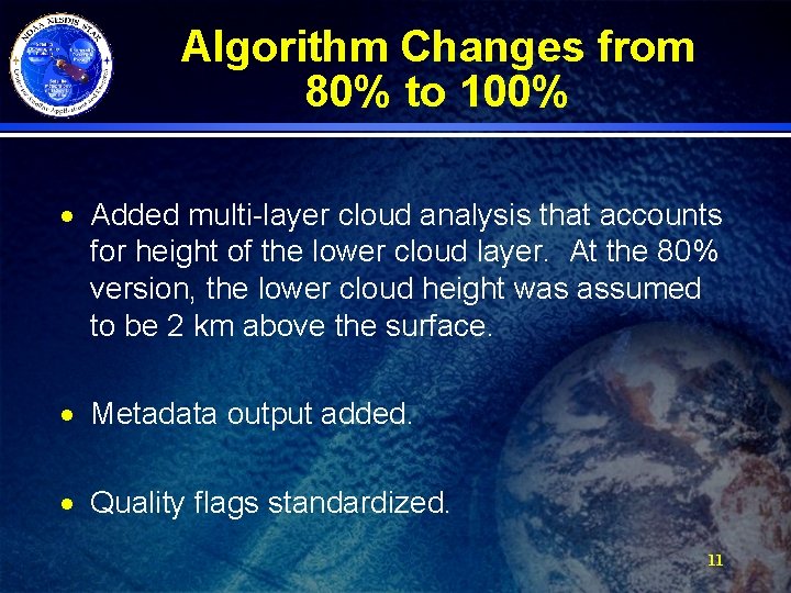
Algorithm Changes from 80% to 100% · Added multi-layer cloud analysis that accounts for height of the lower cloud layer. At the 80% version, the lower cloud height was assumed to be 2 km above the surface. · Metadata output added. · Quality flags standardized. 11

ADEB and IV&V Response Summary · All ATBD errors and clarification requests have been addressed. · No feedback required substantive modifications to the approach. 12

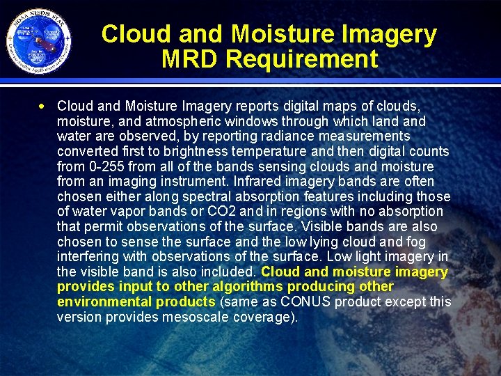
Cloud and Moisture Imagery MRD Requirement · Cloud and Moisture Imagery reports digital maps of clouds, moisture, and atmospheric windows through which land water are observed, by reporting radiance measurements converted first to brightness temperature and then digital counts from 0 -255 from all of the bands sensing clouds and moisture from an imaging instrument. Infrared imagery bands are often chosen either along spectral absorption features including those of water vapor bands or CO 2 and in regions with no absorption that permit observations of the surface. Visible bands are also chosen to sense the surface and the low lying cloud and fog interfering with observations of the surface. Low light imagery in the visible band is also included. Cloud and moisture imagery provides input to other algorithms producing other environmental products (same as CONUS product except this version provides mesoscale coverage).

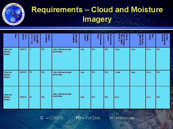
Requirements – Cloud and Moisture Imagery Product Measurement Precision Data Latency Refresh Rate Option (Mode 4) Refresh Rate/Coverage Time Option (Mode 3) Measurement Accuracy Measurement Range Mapping Accuracy Horizontal Resolution Vertical Resolution Geographic Coverage (G, H, C, M) User & Priority Name Cloud and Moisture Imagery GOES-R C N/A 2 km, with finer daytime observations 1 km N/A 5 min 50 sec N/A Cloud and Moisture Imagery GOES-R FD N/A 2 km, with finer daytime observations 1 km N/A 15 min 50 sec N/A 1 km N/A 30 sec 23 sec N/A Cloud and Moisture Imagery GOES-R M N/A 2 km, with finer daytime observations C – CONUS FD – Full Disk M - Mesoscale

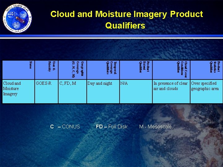
Cloud and Moisture Imagery Product Qualifiers FD – Full Disk Product Statistics Qualifier N/A Cloud Cover Conditions Qualifier C – CONUS Day and night Product Extent Qualifier C, FD, M Temporal Coverage Qualifiers GOES-R Geographic Coverage (G, H, C, M) User & Priority Name Cloud and Moisture Imagery In presence of clear Over specified air and clouds geographic area M - Mesoscale

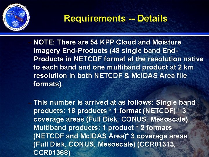
Requirements -- Details – NOTE: There are 54 KPP Cloud and Moisture Imagery End-Products (48 single band End. Products in NETCDF format at the resolution native to each band one multiband product at 2 km resolution in both NETCDF & Mc. IDAS Area file formats). – This number is arrived at as follows: Single band products: 16 products * 1 format (NETCDF) * 3 coverage areas (Full Disk, CONUS, Mesoscale) Multiband products: 1 product * 2 formats (NETCDF and Mc. IDAS Area)* 3 coverage areas (Full Disk, CONUS, Mesoscale) (CCR 01313, CCR 01368)

Validation Approach 17

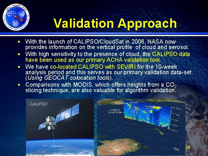
Validation Approach · With the launch of CALIPSO/Cloud. Sat in 2006, NASA now provides information on the vertical profile of cloud and aerosol. · With high sensitivity to the presence of cloud, the CALIPSO data have been used as our primary ACHA validation tool. · We have co-located CALIPSO with SEVIRI for the 10 -week analysis period and this serves as our primary validation data-set. (Using GEOCAT colocation tools). · Comparisons with MODIS, which offers heights from a CO 2 slicing technique, are also valuable for algorithm validation. CALIPSO 18

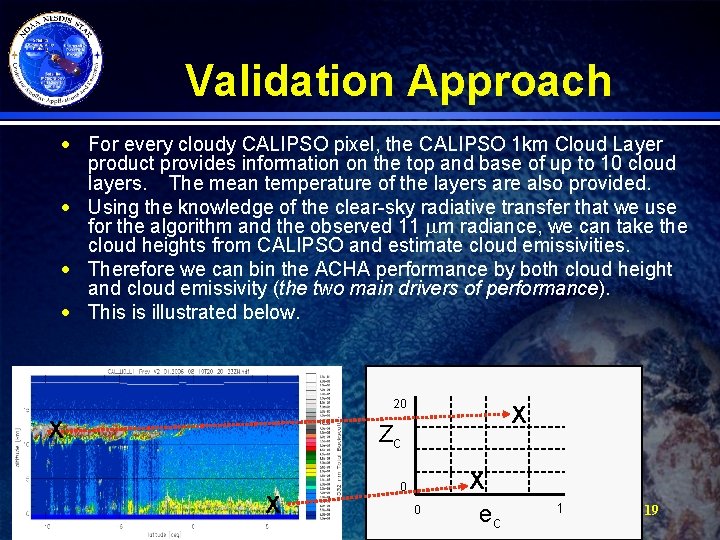
Validation Approach · For every cloudy CALIPSO pixel, the CALIPSO 1 km Cloud Layer product provides information on the top and base of up to 10 cloud layers. The mean temperature of the layers are also provided. · Using the knowledge of the clear-sky radiative transfer that we use for the algorithm and the observed 11 mm radiance, we can take the cloud heights from CALIPSO and estimate cloud emissivities. · Therefore we can bin the ACHA performance by both cloud height and cloud emissivity (the two main drivers of performance). · This is illustrated below. 20 X X Zc X 0 0 X ec 1 19

Validation Results 20

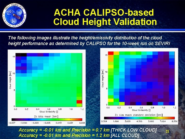
ACHA CALIPSO-based Cloud Height Validation The following images illustrate the height/emissivity distribution of the cloud height performance as determined by CALIPSO for the 10 -week run on SEVIRI Accuracy = -0. 01 km and Precision = 0. 7 km [THICK LOW CLOUD] Accuracy = -0. 01 km and Precision = 1. 2 km [ALL CLOUD] 21

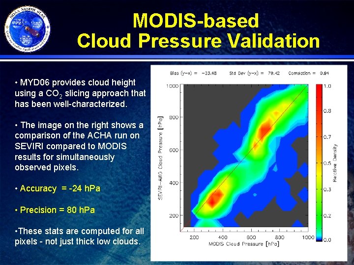
MODIS-based Cloud Pressure Validation • MYD 06 provides cloud height using a CO 2 slicing approach that has been well-characterized. • The image on the right shows a comparison of the ACHA run on SEVIRI compared to MODIS results for simultaneously observed pixels. • Accuracy = -24 h. Pa • Precision = 80 h. Pa • These stats are computed for all pixels - not just thick low clouds. 22

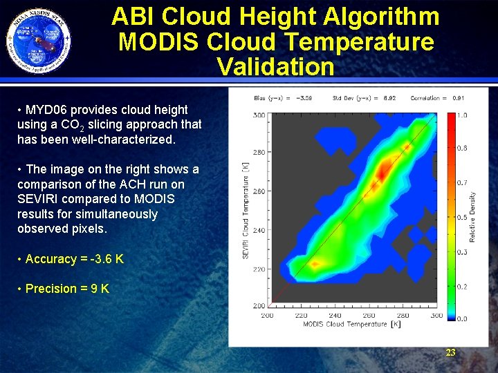
ABI Cloud Height Algorithm MODIS Cloud Temperature Validation • MYD 06 provides cloud height using a CO 2 slicing approach that has been well-characterized. • The image on the right shows a comparison of the ACH run on SEVIRI compared to MODIS results for simultaneously observed pixels. • Accuracy = -3. 6 K • Precision = 9 K 23

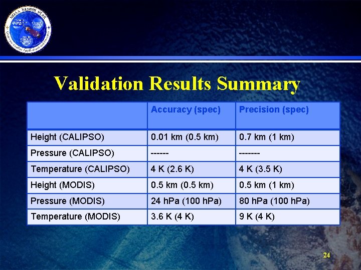
Validation Results Summary Accuracy (spec) Precision (spec) Height (CALIPSO) 0. 01 km (0. 5 km) 0. 7 km (1 km) Pressure (CALIPSO) ------- Temperature (CALIPSO) 4 K (2. 6 K) 4 K (3. 5 K) Height (MODIS) 0. 5 km (0. 5 km) 0. 5 km (1 km) Pressure (MODIS) 24 h. Pa (100 h. Pa) 80 h. Pa (100 h. Pa) Temperature (MODIS) 3. 6 K (4 K) 9 K (4 K) 24

Summary · The ABI Cloud Height Algorithm provides a unique IR-only solution that utilizes the new capabilities offered by the ABI · Version 5 is delivered and the 100% ATBD is coming. · These products meet the specifications and are proving useful to downstream applications (AMV) 25