Global Processes Determine Weather and Climate Weather represents

Global Processes Determine Weather and Climate • Weather represents short-term, local change in temperature, humidity and precipitation. – It can only be predicted a few days in advance • Climate is a long-term pattern of average weather that occurs in a region. General predictions can be made. – Regional differences in climate determines which organisms can survive in a given region.

Reasons for the Unequal Heating of Earth • Angle of insolation varies the amount of energy that strikes the surface of the Earth. – The Sun strikes the tropics at a perpendicular angle. Mid -latitude and polar regions receive solar energy at more oblique angles. • Solar energy is lost as it passes through the atmosphere. Solar energy travels shorter distances through the atmosphere at the tropic regions.

Reasons for the Unequal Heating of Earth • Variation in the amount of surface area receiving solar energy – Near the poles the light is concentrated over a small surface area. – Light at the mid-latitude and polar regions is distributed over a large surface area, giving each square meter of surface less energy.

Reasons for the Unequal Heating of Earth • Different surfaces have different albedo values based on how much light they absorb or reflect. – A white surface has a higher albedo than a black surface. – Earth has an average albedo value of 30%. • The tropics have albedo values that range from 10 -20% • The snow covered polar regions have albedo values that range from 80%-95%

How can humans cause an increase or decrease in albedo? How does it affect global warming? What’s Earth’s average albedo? What types of locations have higher albedos?

Atmospheric Convection Currents • Properties of air that determine how it circulates: Density, water vapor, adiabatic heating/cooling and latent heat release. – Less dense air rises – Warmer air is less dense than colder air – Warmer air can hold more water vapor than cooler air. • The saturation point is the maximum amount of water vapor that air can hold at a given temperature.

Adiabatic Heating and Cooling • In addition to temperature, air responds to changes in pressure. – Air under lower pressure expands and this expansion causes the temperature to decrease. This is adiabatic cooling. – Adiabatic heating happens when cool air sinks, the pressure increases and this causes the temperature of the air mass to increase.

Remember…

Latent Heat Release • It takes solar energy to convert liquid water to gaseous water vapor. • When water vapor condenses back to a liquid this heat is released from the water into the atmosphere. This remind you of your freshman physical science class?

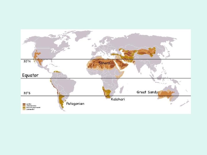
How Convection Currents Form • Global patterns of air movement are initiated by unequal heating of Earth. – moist air is warmed and rises at the equator – Air reaches saturation – Condensation forms clouds – This cold dry air is displaced horizontally to the North and South as warm air continues to rise from the equator – This displaced air eventually sinks at 3 N/S, air is hot and dry (leads to deserts) – This air moves horizontally to replace the rising air at the equator- completing the cycle. – These are called Hadley Cells

Polar Cells & Ferrel Cells • Polar cells form by similar processes as Hadley Cells. • Air rises at a latitude of 6 N/S & sinks at a latitude of 9 N/S. • Ferrel Cells are between the Hadley Cells and Polar Cells – Where Hadley and Ferrel Cells both sink are called Horse Latitudes, an area of generally high pressure – Allows a wide range of cold and warm air to circulate between 3 N/S and 6 N/S – Wind direction can be quite variable in this region

What type of cell effects the USA?
 • The area of Earth that receives the most intense")
Inter-tropical Convergence Zone (ITCZ) • The area of Earth that receives the most intense sunlight. • Found between the two ascending branches of the Hadley Cells. • Typified by dense cloud cover • Not fixed in position. Over the course of a year it moves north and south of the equator (23. N/S) • Accounts for seasonal patterns of precipitation found in the tropics.

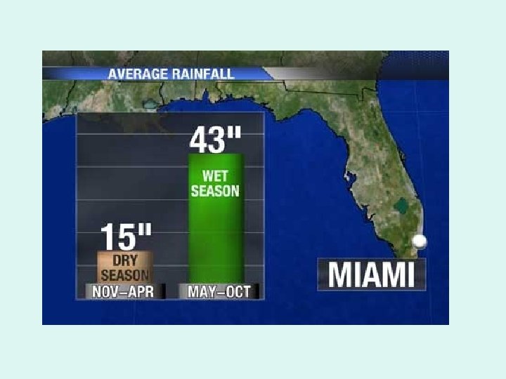
Does the United States experience ‘wet’ and ‘dry’ seasons?

Earth’s Tilt and Seasons • The Earth’s axis of rotation is tilted 23. • This causes seasonal changes at the Earth orbits around the Sun

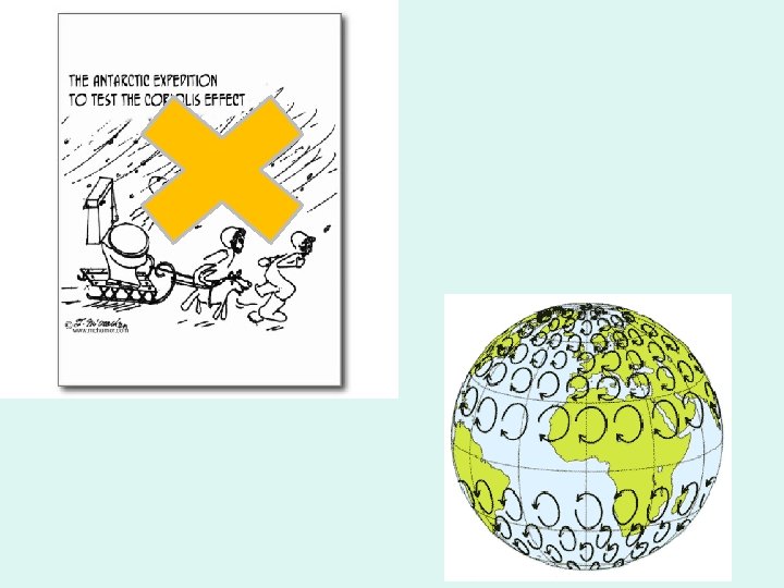
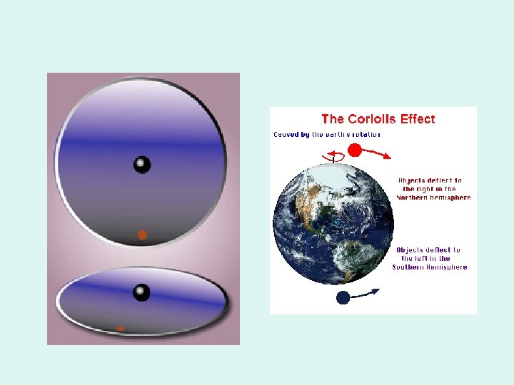
The Coriolis Effect • Earth’s rotation influences the directions of prevailing winds. • As the Earth rotates, its surface moves much faster at the equator than in mid-latitude and polar regions. • This difference in rotation speeds causes a deflection of objects that are moving directly north or south

Travelling… • A flight from Hartford, CT to Seattle, WA takes about 6 hours. The return trip takes about 5 hours. The reason for this is related to the concepts you are learning about. Why does this happen?

Global Winds • The combination of convection cells and the coriolis effect create distinct wind patterns

Rain Shadow Effect • These are created when global winds carry warm moist air onto the coast and the air mass encounters a mountain range – Windward side: Here warm air rises and adiabatic cooling leads to cloud formation and precipitation. – Leeward side: Here cold dry air descends and adiabatic heating creates hot dry conditions.

Ocean Currents Influence Climate • Currents are driven by a combination of temperature differences, gravity, prevailing winds, the Coriolis effect, and locations of continents. – Warm water at the equator rises, while water at mid-latitudes remains at lower elevations. This gradient causes water to flow away from the equator • Gyres: Circulation patterns that redistribute heat in the ocean. – Flow is clockwise in Northern Hemisphere – Flow is counterclockwise in Southern Hemisphere. Watch this video to better understand how ocean currents affect climate

What’s in Sea water?

• Upwelling: deep waters rise to the surface and circulate nutrients and oxygen. – This happens along the western coasts of continents where surface currents diverge. – Leads to increased productivity in the ocean. • Thermo-haline Circulation: circulation is driven density differences based on temperature and salinity – This creates a great ocean conveyor belt that takes hundreds of years to complete. – One concern about global warming is that increased ice melt could make the North Atlantic less salty, and less likely to sink. This might shut down thermo-haline circulation. Vertical Circulation

What connection between temperature & salinity? Why?

Ocean Currents Transport Heat • The Gulf Stream originates in the tropics near the Gulf of Mexico. • It flows Northeast and across the Atlantic Ocean towards Europe. • It brings heat to higher latitudes that would otherwise be much cooler.

El Niño- Southern Oscillation - ENSO • Approximately every 3 -7 years surface currents in the tropical Pacific Ocean reverse. • Movement of warm water and air toward South America suppresses upwelling and decreases productivity. • Globally this causes cooler and wetter conditions in the southeast U. S. & dry weather in southern Africa and southeast Asia.

Various Biomes are Identified by the Unique Adaptations in the Dominant Flora & Fauna • Plants that grow in a desert biome need to be adapted for hot & dry weather conditions. Plants need to be able to store water and resist evapotranspiration. – Organ pipe cactus are found in Arizona. – Euphorbia grow in Namibia. They have similar growth pattern as the cactus, but they possess distinctly different flowers and spines. Only members of the Euphorbia family produce a milky sap.

Climate Diagrams • Visualize annual temperature and precipitation of a given area or biome. • We can look for seasonal patterns. – Rainy times of the year – Growing season – How humans might use different biomes: farming or lumber. Complete Parts 3 A & 3 B of the “Normal Climate Patterns” Lab

Terrestrial Biomes • Fall into 3 major categories – Tundra & Boreal Forest – Temperate – Tropical • There a total of 9 Biomes – – – – – Tundra Boreal Forest (Taiga) Temperate Rainforest Temperate Seasonal Forest Woodland/ Shrub land (Chaparral) Temperate Grassland/ Cold Desert Tropical Rainforest Tropical Seasonal Forest/ Savanna Subtropical Desert

Aquatic Biomes • Categorized by Salinity, Depth & Water flow – – – – Streams & Rivers Lakes & Ponds Freshwater Wetlands Salt Marshes Mangrove Swamps Intertidal Zone Coral Reefs The Open Ocean

Biomes Project • Working independently create a presentation for an assigned terrestrial or aquatic biome. Describe all the different aspects to show that there's more to any particular biome than just plants, animals and climate. (keep the presentation brief) – Provide examples of how the biome is used by humans and the overall ecological value of the biome. – Current conflicts or environmental issues that are occurring in that particular Biome.

What to Include • A portion of your presentation must define the assigned biome in terms of climate and dominant flora & fauna. – What adaptations do the plants & animals have in order to survive in this Biome? – Why would they live in this biome? • A map of the world where this Biome exists. Zoom in on your biome. • Describe the ecological value of your assigned biome. • Information on an environmental issue that is occurring in your biome. – Substantiate this information with either a newspaper article, journal article or a reputable website.

Coffee Farming • Coffee beans come from shrubs that typically grow in the shade of a tropical rain forest canopy. • With a growing demand for coffee, breeders developed sunlight tolerant strains that could be grown in the intense sunlight of open fields. – This method of cultivation attracted pests and disease. – The heavy use of pesticides needed increased the cost of growing coffee, poisoned workers and polluted the environment.

Shade Grown Coffee- Consumer Choices • Some coffee farmers solved these problems by growing their crops in a more natural setting. • They planted coffee bushes within intact forests or planted bushes alongside fields that produce other marketable products. – This attracts fewer pests and reduces the need for pesticides – It also lowers crop yield which leads to more expensive coffee. • The Smithsonian Migratory Bird Center developed a program to offer a bird friendly seal of approval to coffee farmers using these methods because they support a greater biodiversity of bird species than open field farms.
- Slides: 37