
Global Positioning System GPS Trenton Computer Festival 2005
Global Positioning System (GPS) Trenton Computer Festival 2005 1
GPS Haiku • In ultimate cold through solar wind you orbit, to warmth you guide me • Wife says pull over, no clear view of satellites, ask for directions • Batteries are toast, map compass reading not learned, I await searchers TCF Presentation April 2005 Cass Lewart © 2000 - 2005 2
Basic GPS Design • GPS (Do. D) with 24 active satellites, Glonass (Russian Federation) with only 11 active satellites, European Galileo (planning stage) • GPS: Three segments - Space, Control, and User Space Segment: 24 satellites + 4 spares in 12 hour, 20, 100 km, 55º orbits, four satellites in each of the six orbital planes Control Segment: Ground stations adjust satellite clocks, provide orbital parameters (almanac, ephemeris) for each satellite User Segment: GPS receivers provide navigational and time information to users. Strength of the received signal is only 1 billionth of a TV signal TCF Presentation April 2005 Cass Lewart © 2000 - 2005 3
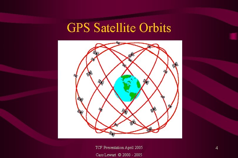
GPS Satellite Orbits TCF Presentation April 2005 Cass Lewart © 2000 - 2005 4
Operating Modes • Precise Positioning System (PPS) - US and allied military, authorized government agencies - 22 m horizontal, 27. 7 m vertical, 100 ns accuracy (95% of time). Resistant to jamming (L 1/L 2) • Standard Positioning System (SPS) - civilian use 100 m horizontal, 156 m vertical, 340 ns accuracy with S/A, improved to nearly PPS values after May 1 2000 (L 1 only) TCF Presentation April 2005 Cass Lewart © 2000 - 2005 5
Operating Modes (cont. ) • Differential Carrier Phase for surveying with postprocessing - at least two receivers - sub cm accuracy • Differential GPS (DGPS) - ground signal required - 1 to 5 m horizontal accuracy • Wide Area Augmentation System (WAAS) - as of February 2004 implemented only in US with 25 ground stations and 2 geosynchronous satellites. Accuracy - 7 m vertical/horizontal TCF Presentation April 2005 Cass Lewart © 2000 - 2005 6
Determining Position on the Globe • Almanac (status and clock information), ephemeris (orbital information) are broadcast to GPS receivers at same frequencies for each satellite (1. 2 and 1. 5 GHz, 20 - 25 cm) • . Different ID codes used by each satellite - Timing information is based on satellite clocks • Cesium/rubidium clocks - 1 sec in 300 years • Triangulation by adjusting receiver clock: 1 ms = 300 meters. TCF Presentation April 2005 Cass Lewart © 2000 - 2005 7
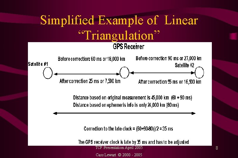
Simplified Example of Linear “Triangulation” TCF Presentation April 2005 Cass Lewart © 2000 - 2005 8
Simplified Example of Linear “Triangulation” • Example: Distance between 2 satellites (from ephemeris information): 24, 000 km or 80 ms (c = 300, 000 km/sec) • Time difference: GPS to Satellite #1 (from almanac information) - 60 ms • Time difference: GPS to Satellite #2 - 90 ms • Conclusion: l clock in the GPS receiver is late by (90+60 -80)/2= 35 ms • Corrected time to Satellite #1: 60 -35 = 25 ms or 7, 500 km • Corrected time to Satellite #2: 90 -35 = 55 ms or 16, 500 km • 4 satellites required for 3 D triangulation TCF Presentation April 2005 Cass Lewart © 2000 - 2005 9
Sources of Error • • • Code noise, receiver noise, satellite clock - 1 m each Ephemeris data error, troposphere delay - 1 m each Unmodeled ionosphere delay - 10 m , multipath - 1 m Satellite constellation geometry - 10 m S/A (RIP) reduced horizontal accuracy from 22 to 100 m (95% of time). S/A was introduced in 1980 and discontinued at midnight on May 1, 2000 by order of president Bill Clinton • Human and software errors can make GPS useless TCF Presentation April 2005 Cass Lewart © 2000 - 2005 10
GPS and Relativity Theory • Special Relativity (SR): Clocks affected by satellite speed relative to earth frame of reference • General Relativity (GR): Clocks affected by differences in gravitational field between satellites and receivers • SR effects compensated by adjusting satellite clock divider ratios - different ratio for rubidium/cesium clocks on satellites and on earth • A 48 page paper describing effects of relativity: http: //arxiv. org/PS_cache/gr-qc/pdf/0306076. pdf TCF Presentation April 2005 Cass Lewart © 2000 - 2005 11
Derived Navigational Information • Lat/Lon in degrees, UTM, and in other units • Local time, UTC, elapsed time, ETA, ETE, altitude • Speed, heading, bearing (true or magnetic) all in land or marine terms (SPD/SOG, HDG/COG, VMG, Landmarks/Waypoints, etc. ) • Distance to destination, distance traveled • “Bread crumb” trail TCF Presentation April 2005 Cass Lewart © 2000 - 2005 12
Types and Cost of GPS Receivers • Hand-held, “watch”, car and boat mounted, PDA attachments ($100 - $1, 000) • Built into cars (OEM) with voice guidance, maps, street and address software with road lock, inertial navigation and DGPS ($1, 000 - $3, 000) • For land surveys with Carrier Phase Comparison and post processing ($5, 000 - $20, 000) • Military with PPS and S/A decryption ($? ? ? ) TCF Presentation April 2005 Cass Lewart © 2000 - 2005 13
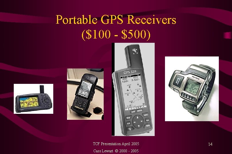
Portable GPS Receivers ($100 - $500) TCF Presentation April 2005 Cass Lewart © 2000 - 2005 14
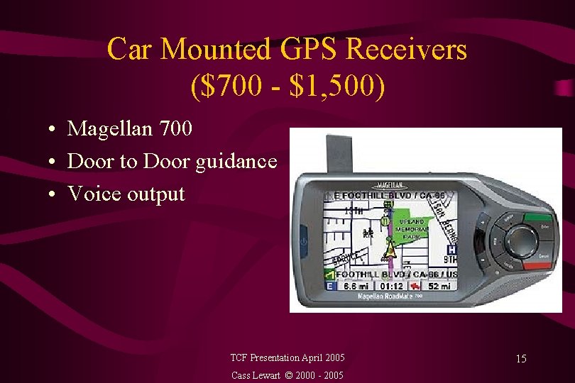
Car Mounted GPS Receivers ($700 - $1, 500) • Magellan 700 • Door to Door guidance • Voice output TCF Presentation April 2005 Cass Lewart © 2000 - 2005 15
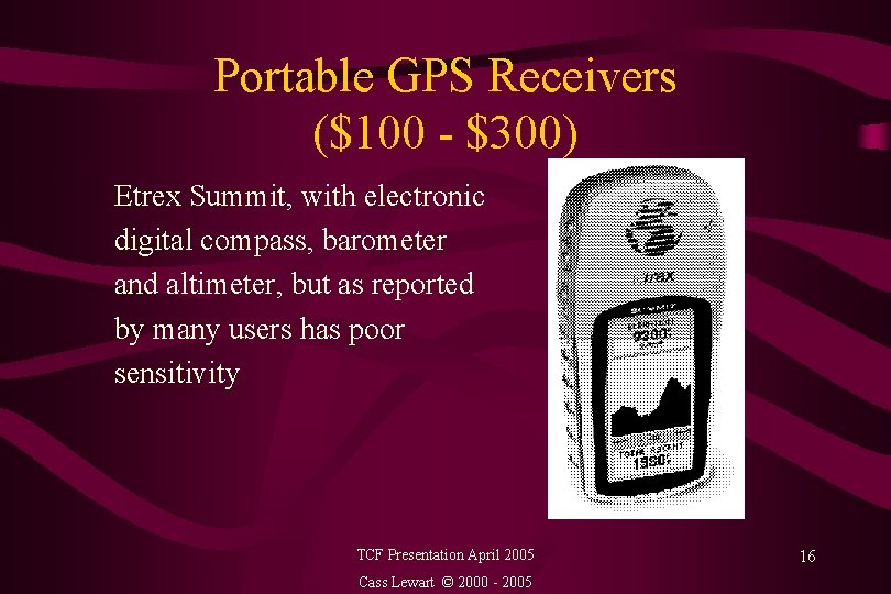
Portable GPS Receivers ($100 - $300) Etrex Summit, with electronic digital compass, barometer and altimeter, but as reported by many users has poor sensitivity TCF Presentation April 2005 Cass Lewart © 2000 - 2005 16
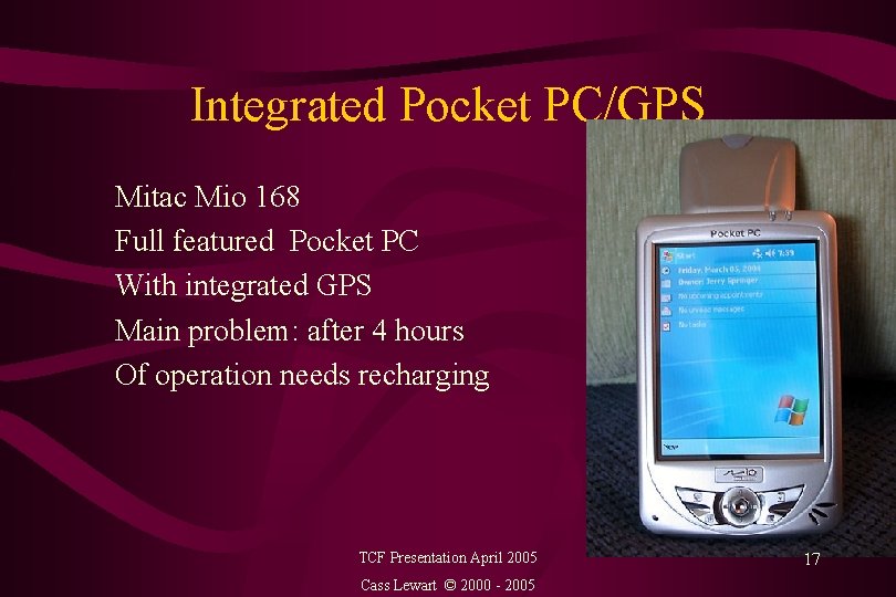
Integrated Pocket PC/GPS Mitac Mio 168 Full featured Pocket PC With integrated GPS Main problem: after 4 hours Of operation needs recharging TCF Presentation April 2005 Cass Lewart © 2000 - 2005 17
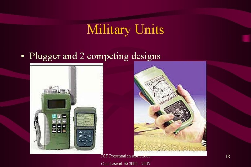
Military Units • Plugger and 2 competing designs TCF Presentation April 2005 Cass Lewart © 2000 - 2005 18
Features in $100 - $1, 000 Price Range • Small manufacturers - Garmin, Magellan, Lawrence • Marketing decides on feature sets and models • Not much advertising - little awareness, except by boat owners and hikers • Storing of waypoints, routes and tracks • 8 - 15 display screens with context sensitive menus • Color display, back light • Depending on price range - user waypoints, city waypoints, fixed maps, maps on cartridges, maps downloadable from CDs, door-to-door voice directions TCF Presentation April 2005 Cass Lewart © 2000 - 2005 19
Additional Features in $100 - $1, 000 Price Range • • Parallel input for up to 18 satellites vs. multiplexed input Selection of map datums, coordinate systems Simulation mode 100 - 1000 waypoints 10 - 50 routes with back tracking, MOB Sun/Moon rise and set, moon phase, dynamic display Wide range of scales on map display (0. 1 - 1, 000 mi) Proximity and other alarms TCF Presentation April 2005 Cass Lewart © 2000 - 2005 20
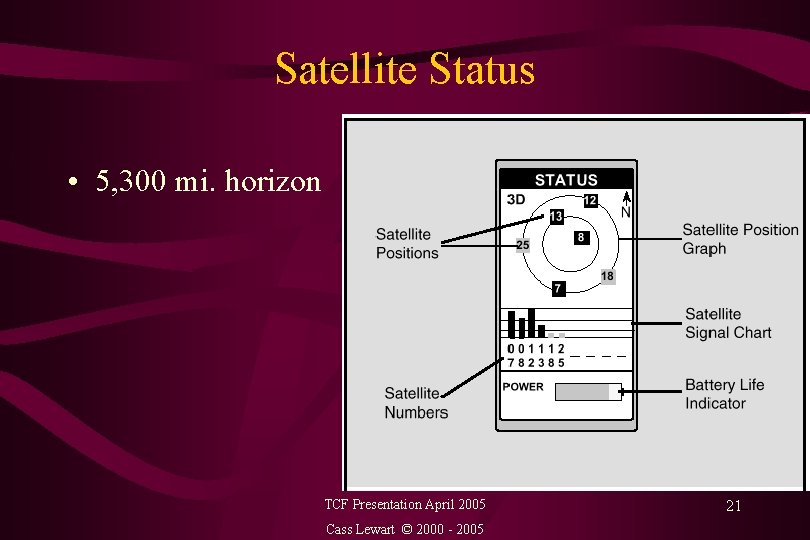
Satellite Status • 5, 300 mi. horizon TCF Presentation April 2005 Cass Lewart © 2000 - 2005 21
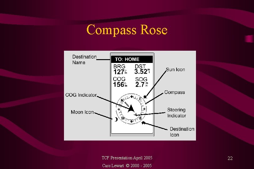
Compass Rose TCF Presentation April 2005 Cass Lewart © 2000 - 2005 22
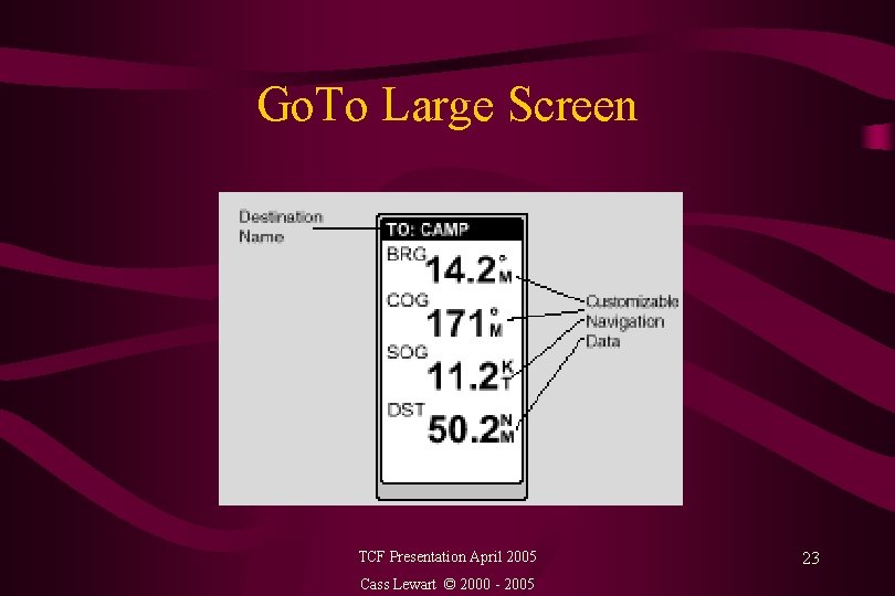
Go. To Large Screen TCF Presentation April 2005 Cass Lewart © 2000 - 2005 23
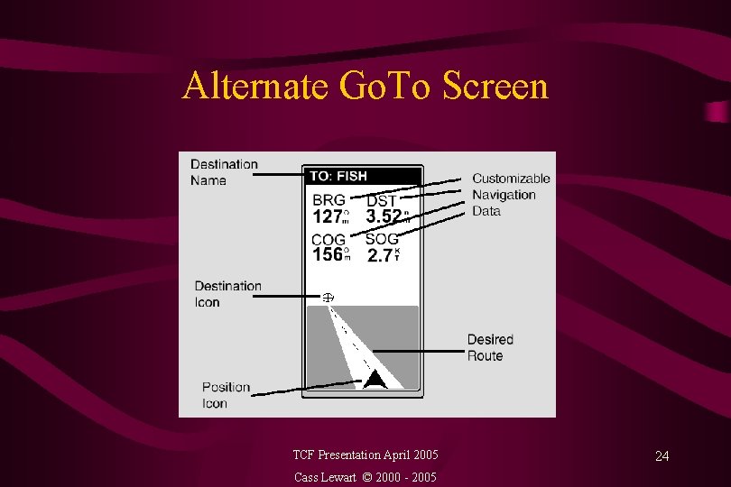
Alternate Go. To Screen TCF Presentation April 2005 Cass Lewart © 2000 - 2005 24
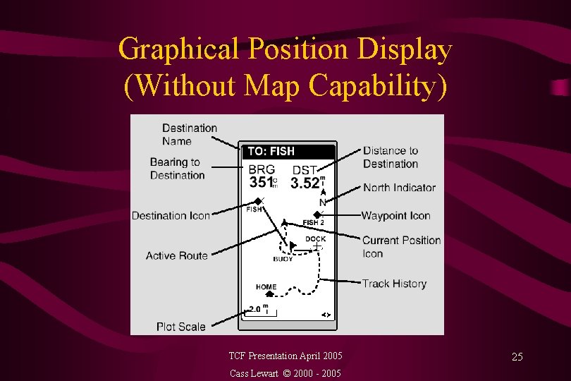
Graphical Position Display (Without Map Capability) TCF Presentation April 2005 Cass Lewart © 2000 - 2005 25
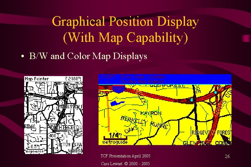
Graphical Position Display (With Map Capability) • B/W and Color Map Displays TCF Presentation April 2005 Cass Lewart © 2000 - 2005 26
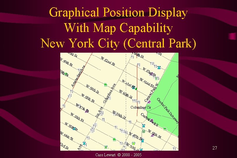
Graphical Position Display With Map Capability New York City (Central Park) TCF Presentation April 2005 Cass Lewart © 2000 - 2005 27
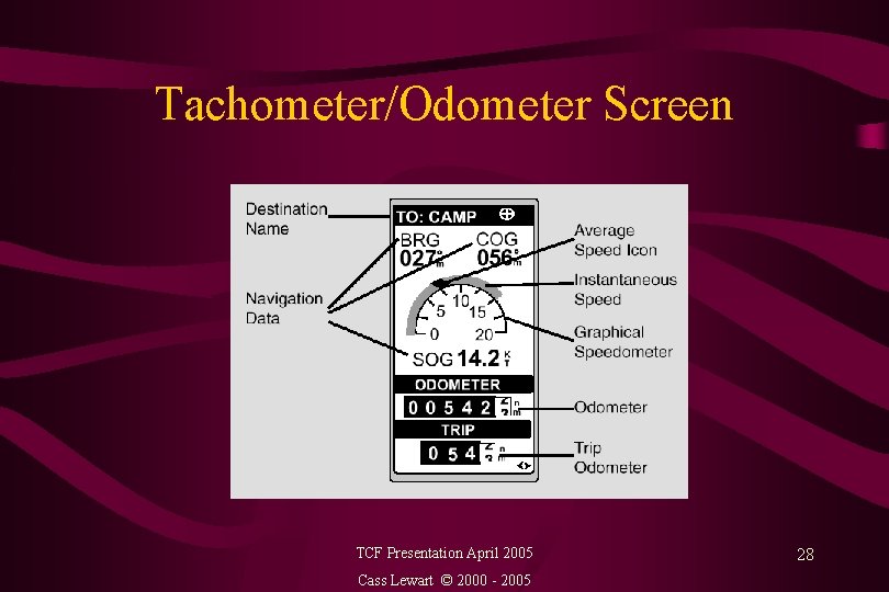
Tachometer/Odometer Screen TCF Presentation April 2005 Cass Lewart © 2000 - 2005 28
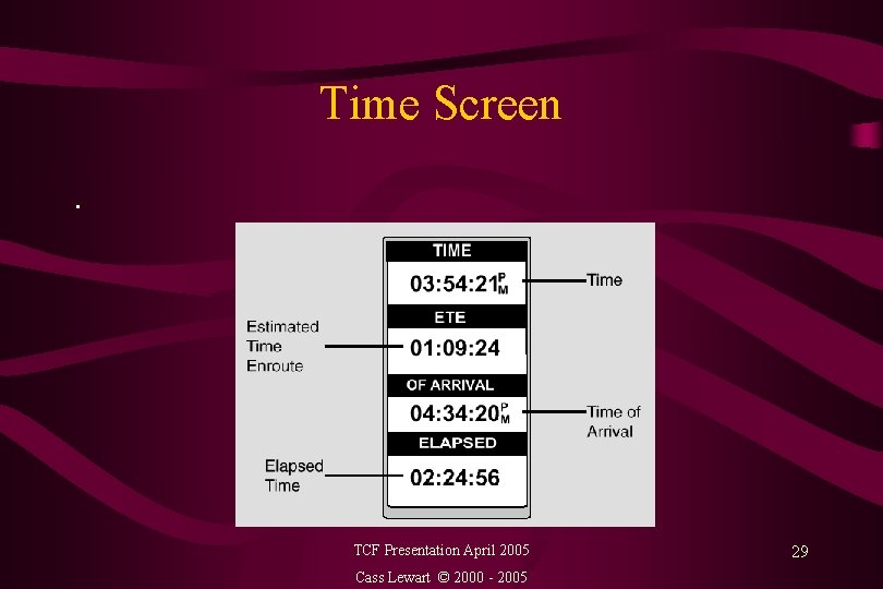
Time Screen. TCF Presentation April 2005 Cass Lewart © 2000 - 2005 29
Flash Memory Usage • Example - Magellan Spor. Trak Pro - 32 Mbytes reserved for base and detailed maps, waypoints, routes and tracks • Installation of detailed maps only possible with proprietary protocols and specific (and expensive) manufacturer’s software, though there are some “hacks” • Basemaps are factory installed but there are ways for uploading and downloading them on some units • Access to user data (waypoints, routes, tracks, current position) available with most commercial software TCF Presentation April 2005 Cass Lewart © 2000 - 2005 30
Hiking and Driving with a GPS • Heading - direction of travel, Bearing - direction to a waypoint • Using a compass, compass rose on GPS (>5 mi/h speed required for accurate heading indication), dynamic Sun/Moon display • Making turns when Bearing and Heading differ by, e. g. , 90 deg or TURN = 90 deg • Marking trail head and trail crossings • Horizontal accuracy - 100 ft or better (after 05/01/00). TCF Presentation April 2005 Cass Lewart © 2000 - 2005 31
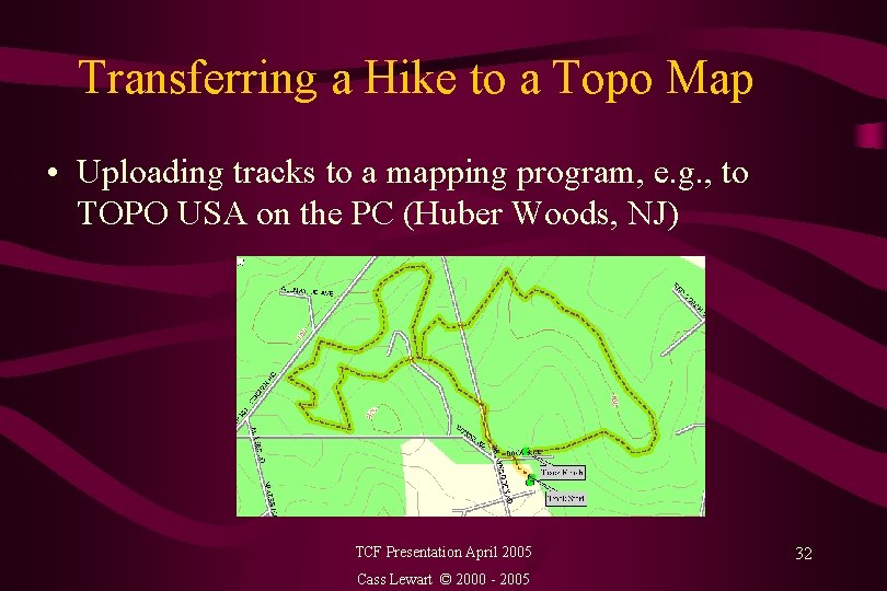
Transferring a Hike to a Topo Map • Uploading tracks to a mapping program, e. g. , to TOPO USA on the PC (Huber Woods, NJ) TCF Presentation April 2005 Cass Lewart © 2000 - 2005 32
GPS On A Commercial Flight • • Hold against window - a great sensitivity test Know where you are, also speed, altitude Flight attendant: “Please put it away” Captain: “You can use it, provided you tell us if we are going off-course. ” • Check if allowed by airline (subject to pilot discretion): http: //gpsinformation. net/airgps. htm TCF Presentation April 2005 Cass Lewart © 2000 - 2005 33
GPS/PC/PDA Connection • RS-232 serial port 1, 200 - 115, 200 bps, also USB • NMEA and proprietary protocols • Software for the moving map display, waypoint, track and route saving, locating streets, addresses • Operating system upgrades distributed via Internet • Commercial software (Street Atlas, Solus, Topo USA), shareware (Ozi Explorer) and free (Mag. Way, Easy. GPS, Track. Maker) • Topo, street maps on CDs and on cartridges TCF Presentation April 2005 Cass Lewart © 2000 - 2005 34
GPS on the Web • General links - http: //gpsinformation. net • Do. D specs: http: //www. navcen. uscg. gov/gps/geninfo/ 2001 SPSPerformance. Standard. FINAL. pdf • Usenet - sci. geo. satellite-nav • Yahoo news groups for specific models • US address search - http: //www. mapsonus. com (don’t forget to convert to your current format, e. g. , dddd to ddd. mm. ss or vice versa!). Also programs such as MS Streets &Trips or De. Lorme Street Atlas • Manufacturer and vendor web pages TCF Presentation April 2005 Cass Lewart © 2000 - 2005 35
Power Sources • 2 - 6 mostly AA batteries, 100 - 200 m. A drain • Primary - Alkaline (2, 000 m. Ah), Lithium (2, 500 m. Ah) • Rechargeable - Ni. Cad (450 - 800 m. Ah), Ni. MH (1, 000 2, 200 m. Ah). Manufacturer specs not reliable • Factors for selection - battery capacity, charging memory, temperature dependence, weight and price • Cigarette lighter cable with voltage regulator (10 -14 V converted to a specific GPS voltage) TCF Presentation April 2005 Cass Lewart © 2000 - 2005 36
Where Do We Go From Here • New generation Block 3 satellites. Higher power (2, 000 W instead of current 500 W) with additional frequencies L 3 through L 5 will replace current Block 2 satellites - 18 out of 24 are past their design limits • Use in civil aviation • Expanded use by emergency services in conjunction with cellular networks (911, On. Star) • Privacy concerns (1984) • Expanded military use (cruise missiles, precision munitions, drones) TCF Presentation April 2005 Cass Lewart © 2000 - 2005 37
Brookdale Computer User Group (BCUG) • Group of 300+ volunteers interested in computers • BCUG is is an independent non-profit organization not associated with Brookdale Community College • Monthly general meetings at Brookdale Community College campus in Lincroft, NJ, monthly newsletter • Currently 18 special interest groups meet monthly at various locations • Dues are $25/year, $20 for non-working retirees • For more information: www. bcug. com TCF Presentation April 2005 Cass Lewart © 2000 - 2005 38
- Slides: 38