GLACIAL AND POST GLACIAL HISTORY ICE LAKES ISOSTATIC


 Summit (block) Mt. Washington Long-standing Dogma All of New")
 Cathedral Ridge Knife Edge and South Peak (2 bedrock)")


, m = 12. 3 ± 0. 9 ky 13. 9")


- Slides: 31
GLACIAL AND POST GLACIAL HISTORY • • • ICE LAKES ISOSTATIC REBOUND TYPICAL STRATIGRAPHY POLLEN AND CLIMATE
WORLD ICE COVER
WATCH ICE RETREAT as well as SEA and LAND LEVEL RISE
GLOBAL SEA LEVEL HISTORY
Ice Extent +Thickness = Ice Volume = D Sea Level Radiocarbon Ages Ridge et al. , 1999 Dyke & Prest, 1987
Mt. Mansfield History Erratic Ludlow, VT Striae Geology of Vermont, Edward Hitchcock, 1861
Unweathered erratics and weak soils suggest overrunning by LGM ice. Mt. Washington Erratics Mt. Katahdin Soil
“Common COSMOGENIC Nuclides”. . .
How are csi’s made? Muons? < 3% Target Atoms 10 Be: O, Mg, Si, Fe 26 Al: Si, Al, Fe Spallation n 4 p t 1/2 = 700 ky 5 to 40 at g-1 yr-1 t 1/2 = 1500 ky 3 n
For long-lived or stable nuclides N = P*t + Inheritance
Goofer Point (block, bedrock, boulder) Summit (block) Mt. Washington Long-standing Dogma All of New England overrun and rock surfaces eroded by continental ice Tuckerman (block)
Baxter Peak (bedrock & block) Cathedral Ridge Knife Edge and South Peak (2 bedrock) Mt. Katahdin North Basin (3 boulders) Basin Ponds Moraine (6 boulders)
Summit Block, Baxter Peak 25. 6± 0. 5 ky 1 st indication something is not as expected
Polished Bedrock, Knife Edge 11. 2 ± 0. 4 ky
North Basin Boulders (n=3), m = 12. 3 ± 0. 9 ky 13. 9 ± 0. 4 ky 10. 9 ± 0. 4 ky On lip 11. 6 ± 0. 4 ky
Pineo Ridge Calibrated 14 C Age 13. 2 to 14. 0 ky Average 10 Be: 26 Al Age 13. 5 ± 0. 6 ky
21. 6, 13. 4, 13. 6 ky 120± 3 ky Mt. Washington 2 nd indication something is not as expected 9. 8± 0. 3 ky
Mt. Washington and Mt. Katahdin, nunataks during late Wisconsinan? Recession. . younging Not likely! 1. fresh erratics 2. weak soils
Sub-summit erosion Was continental ice so thin/cold that it eroded little, leaving nuclides from prior exposure on thecone summits?
9. 3± 0. 5 ky ERRATIC >500 ky total history BEDROCK BAFFIN ISLAND UPLAND
Late Glacial Limit Cactus Rock Bush, Baraboo, Observatory Waterloo
Cold non-erosive upland ice, warm erosive valley ice New England is not unique; there is an Arctic analog. Pangnirtung Fjord, Baffin Island
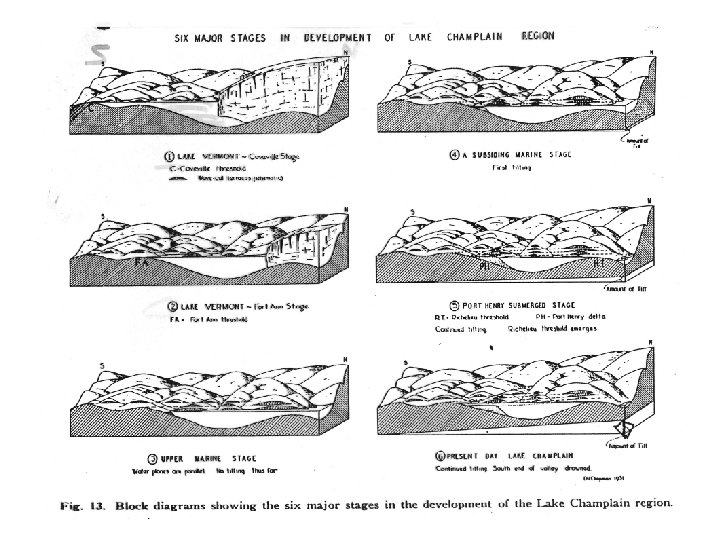
MEAN WHILE, BACK IN VERMONT PREDICTABLE SEQUENCE
= STOWE GULLY EARLY LATER
OBSERVATION: LAKE SHORE FEATURES ARE TILTED SOUTH NORTH Rising to the north
LAKE SHORELINES CAN BE FOUND AT PREDICTABLE ELEVATIONS
WHAT IS IT? ALNUS or ALDER
WATCH PINE MOVE NORTH
VIEW TOGETHER
Eastern N. America 0 White Mtns. Adirondack Mtns. Pollen, Foraminifera Pollen, Macrofossils COOL, WET? meridional flow 2 COOL, WET? spruce increase 6 8 10 12 WARMING, MOIST meridional flow COLD Delcourt and Delcourt, 1984 COOLING? WARM, DRY? pine and birch expand WARMING Spruce Minimum WARM AND DRY strong westerlies Spruce Minimum 4 Max. Seasonality 14 C year BP COOLING? WARM AND STORMY pine and birch expand WARM AND DRY COLD WARMING Jackson and Whitehead, 1991 Spear et al. , 1994