GIS Project Field Data Collection PROJECT MOTIVATION 1

 2. Collaborative success")


- Slides: 30
GIS Project: Field Data Collection
PROJECT MOTIVATION 1. End-of-Life-Cycle workflows in place (Trimbles with Arc. Pad) 2. Collaborative success demonstrated by NHDOT SADES using Arc. GIS Online and Collector apps 3. Potential to use and expand on SADES methodology to benefit natural resource groups and other state agencies
OBJECTIVES 1. Introduce data collection phase to the current “Agency Map Viewers Pilot Project” 2. Adhere to and augment best practices from the map viewer project 3. Demonstrate transferability of NHDOT SADES model to natural resource agencies = collaborative workflow: NHFG, DNCR-Div. of Forests & Lands and NHB, OSI-CLSP state lands infrastructure and natural resource features
STEPS 1. Use ESRI WEBGIS Launch. Kit to jumpstart Arc. GIS Online content and workflows 2. Continue data collection workflow development using ESRI recommendations 3. Deploy final products: o Field data applications for Arc. GIS Online o Public and private facing data viewers
Esri Launch. Kit Overview Participants *Katie Callahan, GIS Coordinator Do. IT-NH Fish & Game Department catherine. callahan@doit. nh. gov (603) 271 -3014 New Hampshire Fish and Game Department Wildlife Division *Jillian Kilborn, Wildlife Biologist *Denyce Gagne, Habitat Management Technician Jim Oehler, State Lands Habitat Biologist Lindsay Webb, Landowner Relations Coordinator Betsey Mc. Naughten, Land Agent Great Bay National Estuarine Research Reserve Rachel Stevens, Stewardship Coordinator/Wildlife Ecologist Inland Fisheries Division Dianne Timmins, Coldwater Fisheries Biologist John Magee, Fish Habitat Biologist *Matt Carpenter, Fisheries Biologist Aquatic Education *Judy Tumosa, Aquatic Ed Specialist *Lisa Scott, GIS Analyst DNCR Division of Forests and Lands lisa. scott@dncr. nh. gov (603) 271 -2679 NH Dept. of Natural and Cultural Resources (DNCR) Division of Forests and Lands Jonathan Horton, Forest Resource Analyst *Cory Keeffe, Community Forester Shaun Bresnahan, Regional Forester Natural Heritage Bureau *Chris Fontenot, Data Manager Bill Nichols, Ecologist/Botanist Pete Bowman, Wildlife Specialist NH OSI – Conservation Land Stewardship Program Amanda Hollenbeck, Stewardship Specialist NH Department of Environmental Services *Dongmei Wang, Do. IT-ASD DES GIS Coordinator *Kristen Svendsen, GIS Coordinator * Asterisk indicates attendance at March 4 -7 training
Esri Launch. Kit Overview Knowledge Transfer Accomplished during the 4 -day Launch Kit Arc. GIS Organization Configuration and Administrative Best Practices • Organizational Components • Homepage and site settings • Creating Groups *Inviting members of other organizations to collaborate • Review User Types, Roles, and Privileges • Users, Groups, and Identity Management Authoring, Registering, and Sharing Content • Gathering Available Data • Publishing Services o Used Forest Inventory data as an example Re-Structuring Existing Data to Suit Multiple Agencies Updated existing Forest Inventory data schema to include a related child table that will be used to store surveys for historical archiving, and republished from Arc. GIS Pro
Esri Launch. Kit Overview Product Development Accomplished during the 4 -day Launch Kit. . . continued First Iteration Products Created with Forest Inventory Feature Service: 1. Collector App 2. Survey form (Survey 123) 3. Link from Collector to Survey 123
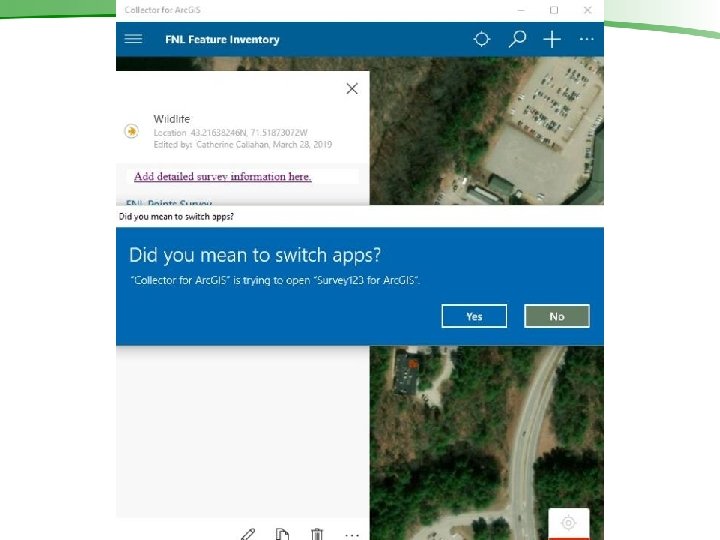
Esri Launch. Kit Overview Product Development Accomplished during the 4 -day Launch Kit. . . continued Additional Products and Topics: • Tile Map Packages and Tile Layers to be used as Basemaps in Collector • Offline data collection workflows in Collector and Survey 123 o Important: Submit new features in Collector for Arc. GIS first before submitting Survey 123 information • Initiated Forest Inventory data viewers: o Operations Dashboard (internal viewers) o Web. App Builder (public-facing external viewers)
METHODS Data Organization | AGOL Set-Up | Field Apps
METHODS Data Organization | AGOL Set-Up | Field Apps
METHODS Data Organization | AGOL Set-Up | Field Apps Hosted Feature Service Online Check settings online Publish Web Layer to AGOL Organize Data Layers in TOC
METHODS Data Organization | AGOL Set-Up | Field Apps 1. Create Web Map with Feature Service
METHODS Data Organization | AGOL Set-Up | Field Apps Survey Title
METHODS Data Organization | AGOL Set-Up | Field Apps
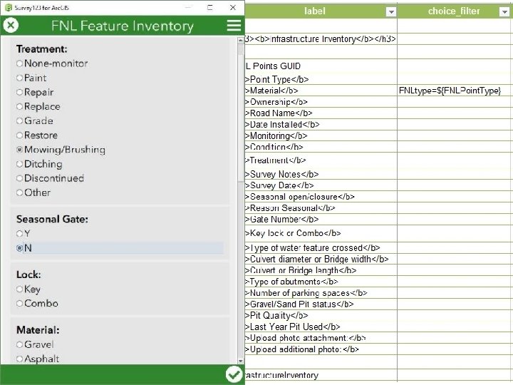
METHODS Data Organization | AGOL Set-Up | Field Apps Copy Child Table Name Paste into form_id
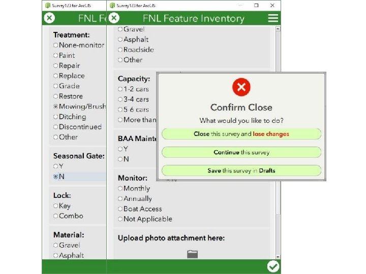
METHODS Data Organization | AGOL Set-Up | Field Apps Link from Collector to Survey 123
METHODS Data Organization | AGOL Set-Up | Field Apps Link from Collector to Survey 123
METHODS Data Organization | AGOL Set-Up | Field Apps
Final Product Overview 1. Organized AGOL Content 2. Shared Groups and Content Between Agencies 3. AGOL Mobile Field Data Collection Apps (Collector & Survey 123) 4. Data Viewers (Operations Dashboard, Web. App. Builder)
Final Product Overview Homepage 1. Organized AGOL Content 2. Shared Groups and Content Between Agencies Thumbnails 3. AGOL Mobile Field Data Collection Apps (Collector & Survey 123) 4. Data Viewers (Operations Dashboard, Web. App. Builder) Content/Group Information
Final Product Overview NHFG and DFL Members 1. Organized AGOL Content 2. Shared Groups and Content Between Agencies 3. AGOL Mobile Field Data Collection Apps (Collector & Survey 123) 4. Data Viewers (Operations Dashboard, Web. App. Builder) Data Collection Group
Final Product Overview 1. Collector App 1. Organized AGOL Content 2. Shared Groups and Content Between Agencies 3. AGOL Mobile Field Data Collection Apps (Collector & Survey 123) 4. Data Viewers (Operations Dashboard, Web. App. Builder) 2. Survey form (Survey 123) 3. Link from Collector to Survey 123
Final Product Overview 1. Organized AGOL Content 2. Shared Groups and Content Between Agencies 3. AGOL Mobile Field Data Collection Apps (Collector & Survey 123) 4. Data Viewers (Operations Dashboard, Web. App. Builder) 1. Web. App Builder and Operations Dashboard (in progress)
Conclusions and Transferability 1. Detailed guide provided by ESRI WEBGIS Launch. Kit to organize AGOL site and configure mobile apps 2. Additional Field Guide created by NHFG for using Collector app and jumping to Survey 123 out in the field 3. Documentation can be used by other groups/agencies to jumpstart similar workflows
Take web maps offline Ensure all layers are enabled for offline use. Under Map Areas, click Manage Areas Create Area and navigate to a part of the map Type a descriptive name for the map area Level of Detail Slider Update packages for download: set interval and time map area packages will be refreshed (re: changes to feature layer data) can select “Never” Refresh does Not apply to tile layers. Web map can have up to 16 map areas.
Advanced offline settings Ensure all layers are enabled Control feature and attachment delivery: 1. ) Editable features, choose deliver both features and attachments, features only, or neither. 2. ) Read-only features, choose deliver both features and attachments or features only. Use a tile package for the offline basemap, choose: 1. ) Device will use the basemap defined by the web map 2. ) Device will use a tile package it already has—if choosing this option, ensure the tile package covers the area or areas you plan to work with offline. Click Save to save your changes. If you modify these settings after you create preplanned map areas, you will need to re-create the map areas.
Web. GIS Launch Kit March 4 -7, 2019 THANK YOU to Jennifer Laws Technical Advisor / Consultant / Project Manager / Platform Engineer Esri Professional Services - Redlands, CA