GIS LECTURE 1 Introduction to GIS Outline u


 are computerized systems designed for")


 15")
 16")
 17")


 u Aerial photography")


 Main menu Table of contents Tools toolbar Standard toolbar Map")
 extension “Points” to layers Saves layer colors,")
 § USStates")


- Slides: 65
GIS LECTURE 1 Introduction to GIS
Outline u GIS overview u GIS data and layers u GIS applications and examples u Software overview u GIS 20 chapter 1 overview 2
Lecture 1 GIS OVERVIEW
What is GIS? u u Geographic Information Systems (GIS) are computerized systems designed for the storage, retrieval and analysis of geographically referenced data GIS uses advanced analytical tools to explore at a scientific level the spatial relationships, patterns, and processes of cultural, biological, demographic, economic, geographic, and physical phenomena Got that? 4
Tools for GIS u Hardware § § u Software § § § u Computer Scanner GPS Printer/Plotter Desktop GIS Web GIS Mobile GIS CAD Software Database Software Multimedia (photos, videos, 3 D models) 5
Unique capabilities of GIS u u GIS stores related geographic features in separate collections of files called map layers Map layers can be reused easily and assembled into any number of map compositions and overlaid for analysis 6
GIS answers the following u Location: What is at. . . ? Where is it? u Condition: Status of features? u Trends: What has changed since. . . ? u Patterns: What spatial patterns exist? u Modeling: What if…? 7
Scale of GIS data Global to local 8
Vector data u Map features § Points, lines, polygons u Feature attributes § Every feature has attributes (e. g. name, area, population) Shape Name Class Pop 2000 State Point New York City 8, 008, 278 NY Point Los Angeles City 3, 694, 820 CA Point Chicago City 2, 896, 016 IL 9
Raster Data Stored electronic image or picture taken as an aerial photograph or satellite image Composed of a rectangular array of square cells, called pixels, with a number in each cell representing the solid color fill of that cell 10
Lecture 1 GIS DATA AND LAYERS
GIS example u u Identify polluting companies and their proximity to populations in poverty, water features, or schools. Start with § Databases § Map layers 12
Databases Not easy to interpret 13
Data shown as GIS layers 14
Additional layers Political features (municipalities) 15
Additional layers Physical features (lakes, rivers, etc. ) 16
Additional layers Administrative data (schools) 17
Maps and tables are interactive Identify features 18
Maps and tables are interactive Select features 19
Advanced GIS functions Proximity selections 20
Advanced GIS functions u Buffers § Select top polluting companies and show the number of schools within 2 miles of these companies. 21
Lecture 1 GIS APPLICATIONS AND EXAMPLES
GIS applications A/E/C Civil engineering, surveying. Business Site location, delivery systems, marketing, media and press, real estate. Defense/intelligence Military operations, geospatial intelligence Government Federal, state, local, economic development, elections, urban and regional planning. Health Public health, health and human services, hospitals, managed care, research. Natural resources Agriculture, archaeology, climate change, conservation, environmental management, forestry, marine and coast, mining, petroleum, water resources. Public safety Computer-Aided Dispatch, emergency/disaster management, EMS, homeland security, law enforcement, fire protection, wildfire management Transportation Aviation, highways, logistics, railways, ports and maritime, public transit Utilities/communications Electric, gas, pipeline, telecommunications, water/wastewater 23
GIS examples u u Instructor should add examples specific to their industry or teaching here What an excellent idea. I think I have just a few examples here… 24
Analysis
What Should Be Anticipated for a Katrina-Magnitude Disaster?
Responding to Citizen Requests in Torrance—Using GIS to Focus Field Investigations City of Torrance
School Facility Needs Analysis
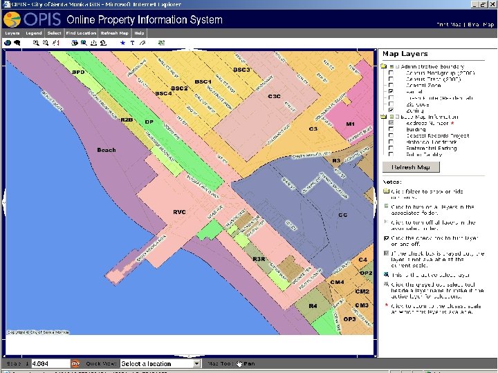
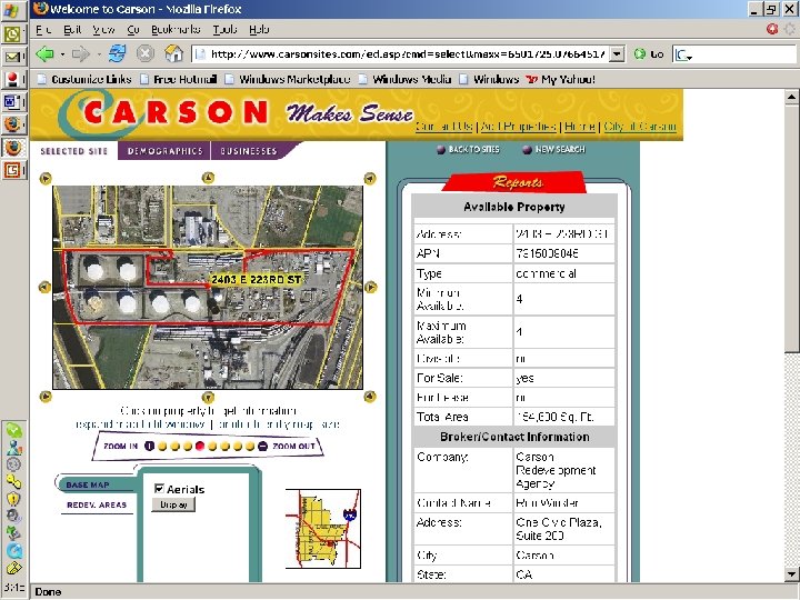
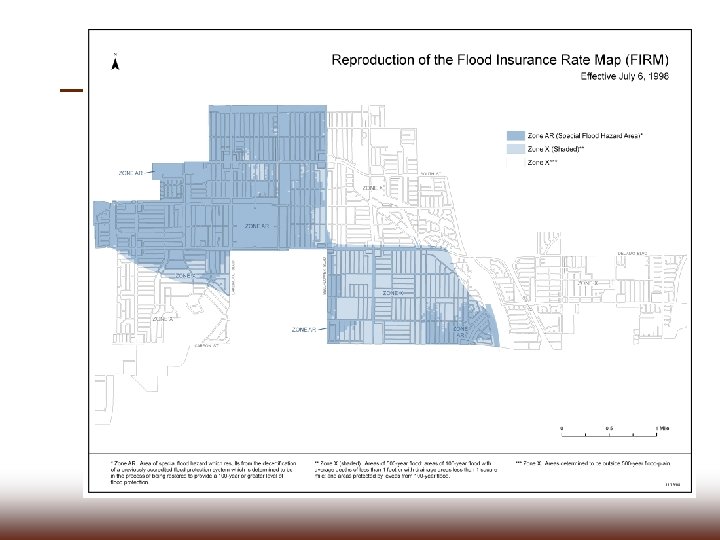
Zoning and Property Information
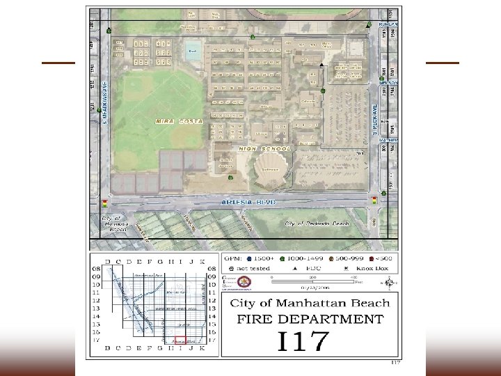
Fire Station Siting
Operations & Special Event Planning Hometown Fair & 10 K Arts Festival Grand Prix Robinson Fun Run Grandview Gator 5 K Earth Day Fireworks Festival
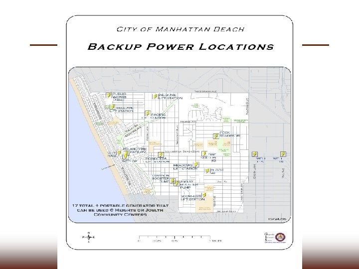
City of Lomita Response to Los Angeles Co. Office of Emergency Mgmt. Information Request
Tabular Data
Compared to a picture
Traffic Accident Analysis
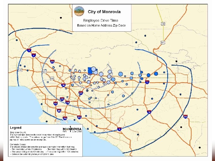
Transportation • Route planning • Route locater • Identification of funding
Economic Development u u u u Sales tax provides 40% of the city’s revenue Licenses and permits make up another 11% Other revenue sources are eroding Good jobs make for a stable community Retaining existing businesses saves jobs New businesses and development can replace blight Economic development is proactive
Tabular Data
Maps u u u Use maps to enhance text based marketing Use vicinity maps to contrast with other communities Demonstrate the unique strengths of your community u Show target areas u Demographics!
Analysis u u u u Know thyself! Identify under-served markets Find potential development sites Identify areas in need of redevelopment Overlay projects with other activities to avoid conflicts Make better informed decisions Cluster projects Identify labor pool
Business Analyst Online Demo
arcgis. com
Redistricting
Related technologies u Global Positioning System (GPS) u Aerial photography
Data Gathering with GPS
What can’t GIS do? u u u u Make decisions -- it is a tool Solve problems alone Replace legal documents (parcels) Generate money by selling data Can’t make a silk purse from a sow’s ear (GIGO) Make your data more accurate Update itself Work by itself -- needs data and trained staff
Lecture 1 SOFTWARE OVERVIEW
Arc. Map (Desktop GIS) Main menu Table of contents Tools toolbar Standard toolbar Map document window Identify results window 57
Map documents u u u (. mxd) extension “Points” to layers Saves layer colors, symbology, etc. 58
Layers u Two layers § USCities (red points, restricted to major cities) § USStates (yellow polygons) 59
Adding map layers Separate files added to a map document 60
Geodatabases The geodatabase is a "container" used to hold a collection of datasets (GIS features, tables, raster images, etc). Country layer World. gdb Graticule layer 61
Arc. Catalog Arranges and manages geographic information in workspace folders and geodatabases. 62
Tutorial Tips u No spaces in file names! u Check that files/folders are not Read-Only u Some results you’ll need to save for use in later labs u Send the result from the end of the chapter
Tips u Just try u It’s so easy, even a manager can do it u Ask for help and be willing to help your colleagues 64
You’re going too fast/slow! u u u Some tutorials will be in class to have help available Some tutorials will be on your own because class time is limited We will not do tutorials together or you would go crazy 65
READ!!! u Don’t just be a button clicker u Read the text, not just the instructions u Don’t skip steps u Don’t freak out if something goes wrong u Learn from each other 66
Summary u GIS overview u GIS data and layers u GIS applications and examples u Software overview u GIS 20 Chapter 1 overview 67