GIS Analysis Function Contents Integrated Analysis of Spatial


- Slides: 26
GIS Analysis Function
Contents Integrated Analysis of Spatial and Attribute Data n Retrieval, Classification and Measurement Functions n Neighborhood Operations n Connectivity or Network Functions n
Integrated Analysis of Spatial and Attribute Data n The power of GIS lies in its ability to analyze spatial and attribute data together. n The range of analysis procedures in this group is very large
Categories Retrieval, Classification and Measurement Functions n Overlay Operations n Neighborhood Operations n Connectivity or Network Functions n
Retrieval, Classification and Measurement Functions In this, spatial and attribute data are retrieved n Only the attribute data are modified or created n No changes are made in the location of spatial elements and no new spatial elements are created n
Retrieval Functions q Retrieval operation can perform on both spatial and attribute data q It involves: n n q No Search Output of data need to modify the geographic location of features q No need to create new spatial features
Classification Functions n Classification n n The procedure of identifying a set of features as belonging to a group. Classification can be n n Vector Based GIS Raster Based GIS
Measurement Functions n Spatial measurement functions include: Distance between features n Length of line n Area of polygon n
NEIGHBOURHOOD OPERATIONS Evaluate the characteristics of the area surrounding a specified location. n Every neighbourhood function requires at least three basic parameters: n n One or more target location. Specification of the neighbourhood around each target. A function to be performed on the elements within the neighbourhood
Example n Counting the number of houses within a 5 Km radius of a fire station. n Target is the fire station n The specified neighbourhood is the area within a 5 Km radius. n The function is to count the number of elements that are houses.
Types of Neighbourhood functions n The most common types of neighbourhood functions are n n n Search function Topographic function Interpolation
Search function can perform on one or more data layers n There can be two categories of search functions n n n Predefined search functions User defined search functions
Predefined search functions n In this, user just selects one of those offered in the GIS softwares. n n Selection By attribute Selection By Location Selection By Graphic Both type of search functions can work on numerical and thematic data
User defined search functions In this, operator is able to enter an equation. n Select houses that have more then 500 bedrooms and are less then 5 years old n
Line in polygon and Point in polygon Operations n Identification of points and lines contained within a polygon area n It is simply an overlay operation with the polygons in one data layer and point or lines in second data layer
Topographic Functions n Topography n n Refers to the surface characteristics of an area Example: n n Topography of Land area Hills, Valley and Plains
Topographic Functions Topography can be defined by elevation of each location n In GIS, topography can be represented by the DEM n DEM build up with the help of Digital Elevation Data. n
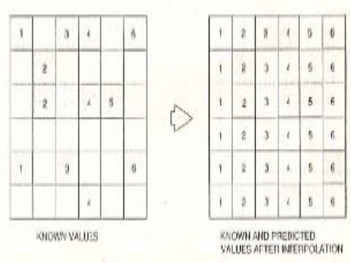
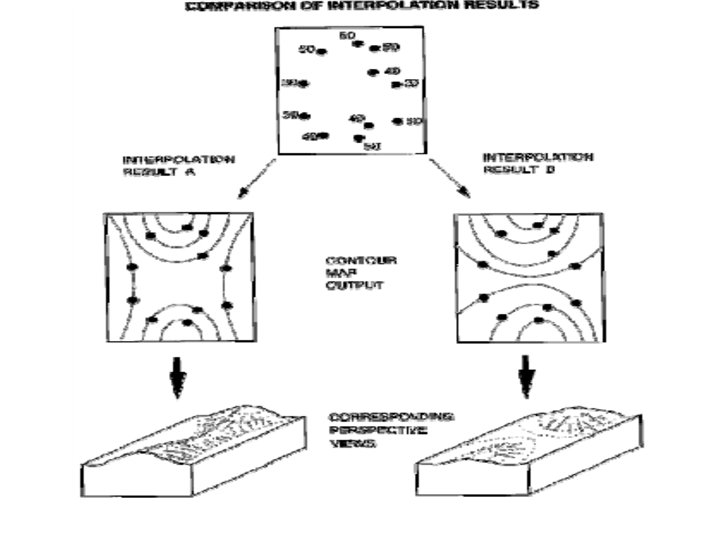
Interpolation n The procedure of predicting the unknown values using the known values at neighbouring location
Contour Generation n Contour lines connect points with same elevation value.
CONNECTIVITY FUNCTIONS Every connectivity function include the following: n How interconnect the spatial elements (such as streets). n A set of rules for movement. n A unit of measurement n
Example n n n A connectivity function for travelling along city streets. First interconnect the streets using street map. The rules for movement on streets might be: n n n One way street or Two way street Speed limit The measurement unit might be distance n e. g find the travel distance between the two points along the street network.
Network functions n A network is a set of interconnected linear features n Examples n n A city’s streets A grid of power transmission lines etc
Network functions n A GIS is used to perform various types of network analysis. n n Route optimization Resource allocation etc
Resource Material Chapter 7 Aoronoff S. “Geographical Information System-A Management Perspective” n Handouts Geographic Analysis n