GFA Icing Turbulence and Freezing Level The GFA

GFA Icing, Turbulence and Freezing Level

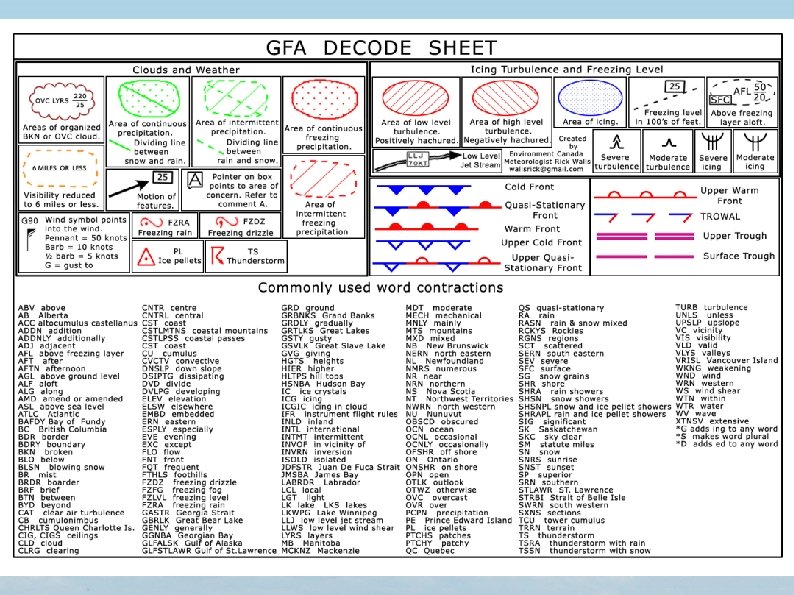
The GFA only forecasts non-convective turbulence and icing. It is to be understood that there is significant icing above the freezing level in convective cloud and significant turbulence in and around convective cloud. Convective cloud will be mentioned if forecast. The convective clouds are CU, TCU, CB, and ACC.

CU

TCU

CB

ACC

Types of Icing ● ● ● Rime - White and opaque. Looks like the frost in your refrigerator Clear (CLR) - Transparent like the ice on a pond after a cold night. Mixed (MXD) - A combination of rime and clear.

Types of Turbulence ● ● ● Mechanical - Strong surface wind creating eddies in the low levels. CAT - Clear Air Turbulence in the high levels that may or may not be associated with cloud. Lee Wave - Turbulence on the downwind side of mountains. Convective turbulence is not forecast but the cloud type is, which indicates turbulence. Wake turbulence is not forecast. Low Level Wind Shear (LLWS) is mentioned when significant.
 symbols")
Icing and Turbulence Symbols These are the standard ICAO (International Civil Aviation Organization) symbols that appear on a GFA.
 In increments of 2500 feet starting at SFC")
FZLVL Lines (Freezing Level) In increments of 2500 feet starting at SFC

Depictions on Icing Turbulence and Freezing Level Chart Features such as Highs, Lows, and Fronts along with their motion arrows are plotted on the Icing Turbulence and Freezing Level chart the same as on the Clouds and Weather chart. In addition the depictions shown to the left describe the icing and turbulence only if it is forecast to be moderate or severe.

GFA Only Forecasts Moderate or Severe Icing and Turbulence Blanket statement indicates possibility of light icing and turbulence.
 Blue = ICG (Icing) Type and intensity of icing and")
Red = TURB (Turbulence) Blue = ICG (Icing) Type and intensity of icing and turbulence written in each area.
 Low level turbulence positively hatchured and high level")
Low and High Level TURB (Turbulence) Low level turbulence positively hatchured and high level turbulence negatively hatchured.

Low and High Level TURB Low level turbulence positively hatchured and high level turbulence negatively hatchured.

SVR TURB Severe turbulence heavily hatchured

If it’s Blue it’s Icing A description of icing type and intensity is written within the area.

SVR ICG Severe Icing heavily stippled. Severe Icing usually associated with an above freezing layer aloft (AFL) and FZRA or FZDZ.
 LLJ only shown if winds between 1000 and 5000")
LLJ (Low Level Jet Stream) LLJ only shown if winds between 1000 and 5000 feet are forecast to be 40 knots or greater.

Practise

END
- Slides: 23