Geospatial ImageMapping Terrestrial Intelligence on Command AN AIRBORNE

Geospatial Image-Mapping & Terrestrial Intelligence on Command AN AIRBORNE HIGH RESOLUTION Thermal-Infrared and Multi-Spectral MAPPING SYSTEM. . . Trials in the Suwannee River Basin, FL (November 2002)

Turtle Bay FL - November 2002 Fresh Water Spring Seep Mapping

Possible fresh water spring

200 image Three band CIR geo. TIF mosaic G 550 nm R 650 nm IR 805 nm

Thermal Imagery is used on aircraft flying at 3000 ft AGL to locate natural springs and warm water seeps during winter months. Temperature scale is approx. . 15 C degrees between intensity of black (cooler) and white (warmer) Thermal imagery spatial resolution 60 cm

Detail of Sub-Surface Structure

Image re-sample Contrast Compression is used to enable detailed analysis of sub-surface Structure more clearly.

300 image mosaic Spring Creek FL 30 cm CIR

Spring Source 250 image mosaic Spring Creek FL 30 cm CIR

Spring Source note the difference in temperature of warmer stream than one to west

Elbow River Weaslehead Glenmore Reservoir, Calgary AB Aug 22, 2002 Hidden Channel mapping 30 cm CIR 150 image mosaic

USGS 1 m DEM Weeks Bay Magnolia River Fish River Gulf Shores Alabama Aug 04, 2004

USGS 1 m DEM & Thermal Weeks Bay Magnolia River Fish River Gulf Shores Alabama Aug 04, 2004

Thermal Profile of Magnolia River

Thermal Profile with temperature measurement

Thermal re-sample to look at thermal differential in more detail Scale 250 ft

29. 1 28. 6 C Source of Magnolia River Scale 2500 ft

Scale 2500 ft

Scale 1000 ft

Fish River

Scale 1000 ft

Tributary course mapping - Thermal Infrared

Moisture and Stream mapping - 150 image mosaic

Thermal Map - 900 image mosaic

Moisture Distribution Analysis

Industrial Intelligence – An Airborne View Industries everywhere, require intelligent information to manage assets and conduct efficient mission operations. “Smart-Data” requires “Smart-Systems” that “combine” a number of technologies that are operated from a unique vantage-point (airborne). We use Fully digital configurations, with fast & sophisticated processing that provide rapid response and wireless delivery of imagery where and when it is needed.

Image Mapping Intelligence – Target Markets Our Airborne Image-Mapping Services was designed for. . . – Fire-Mapping & Fire-Suppression Mission-Critical Initiatives The system was seen as a natural fit for. . . – Agriculture & Environmental Management Crop Control (Maximizing/Minimizing/Eradication) Water, Fertilizer & Augment Programs – Environmental Herd, Livestock & Wildlife Migration & Management Vegetation Waterways Terrain, Space & Territory Planning Emergency Response & Logistics (Earthquake, Flooding, etc. )

Start of Lost Creek Fire, Alberta Canada Our system was designed for rapid delivery of mapping imagery

Fire Mapping & Fire Suppression Hundreds of millions of dollars are spent fighting fires in North America every year. Intelligent-Mapping realizes huge savings of valuable resources, by deploying them mostaccurately where the action is needed most.

Mission Critical Operations – Fire Suppression Accurate, and to the “minute” intelligent mapping and pinpoint 3 D visual information provides 100% effectiveness applied to fire-fighting operations.

Aerial attack plans, 3 D visualization assists Mop-Up Fire Suppression Fire Mapping We have designed a 3 D system. That is, produce an ortho-rectified thermal mosaic and place it onto the 3 D Terrain Model or DEM.

Aerial Infrared-Imaging Today, Mop-Up Fire Detection 2004 What you Can’t see, Can Hurt you!!

Fire. Map 24 hrs later

Fire Mapping Navigate to the spot with simple hand held devices. The 3 D maps are put back in the field with ruggedized pen tablet or hand-held with GPS to navigate to the area of interest in real-time

…for that matter, to go one step further, technology is available today in broadband wireless systems to email the image mosaics back to the field or suppression aircraft. Ground personnel will have the very accurate thermal hot spot map with GPS to virtually stand on the hot spot if it’s hard to find. . .

Image-Maps are geo. TIF files and are used on Laptops and PDA devices with GPS immediately, as moving map displays to navigate.
")
The Technology - GPS Track Over Image (2 m accuracy)

Raymond MS Airport 60 image thermal mosaic

The Technology Sub-pixel Fire Detection

Image Mapping Intelligence – Target Markets As well as. . . – Terrestrial Based Assets (Energy & Utilities) Oil & Gas, Pipeline Transport Electrical & Powerline Roads, and Surface Transport Facilities Dams & Holding Structures Commercial/Industrial Buildings and Structures

Pipeline Location Mapping

Asset Management Pipeline Mapping Electrical Grid Mapping Railway, Road, Transport Bridges, Terrestrial Assets Buildings, Commercial Property
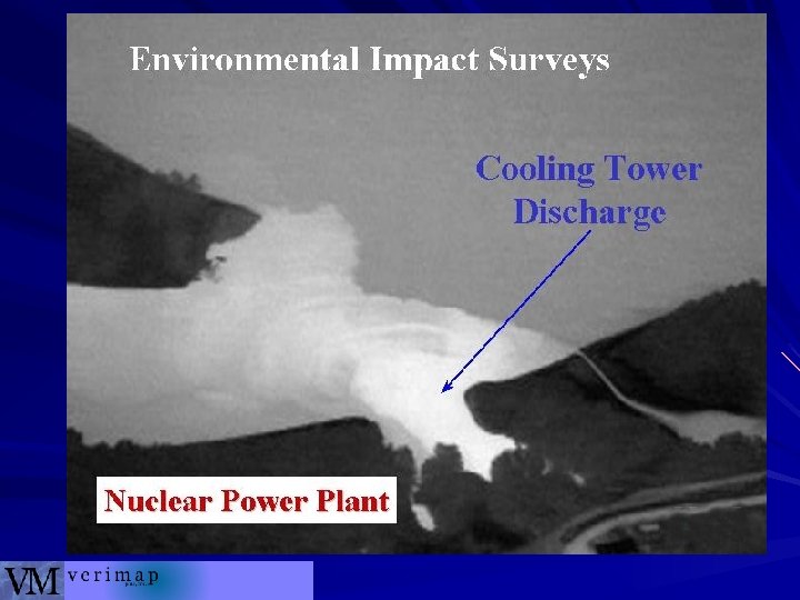

Thermal plume discharge. . .

How to read a Thermogram White is warmer Black is cooler

Note the warm discharge thermal pattern in area. . . Veri. Map PLUS

The Technology A quick tour …

Airborne MK IV installed Jan 2000 Pilot digital navigation electronic flight display keeps driver online Twin Engine Cessna 337 E Sky. Master Laser Camera

. . . corridors or many strips together, to mosaic the big image-map Moving Map Display for pilot Navigation

Direction of Laser Flight 5000 to 75, 000 pulses per second Laser Pulse Laser Spot Size Scan Line 15 - 20 cm GPS Reference Base Station The Principle of Scanning Li. DAR

Ft Mc. Murray, AB …approximately 700 50 cm images total

Veri. Map Ft Mc. Murray, AB

State of the Art Processing

To initialize our automated rectification and mosaic routines, we require… • digital imagery (. tiff) with event marker tags • the DGPS flight trajectory • the detailed Li. DAR DEM • INS orientation tags

Quality Control verifies we have complete coverage over the area of interest (no imagery gaps allowed). We then create intermediate file sets of • imagery orientation from the INS/trajectory • a DEM. geotif at the final image resolution Rectification of each image is completed. Then a mosaic is run to create the tiles of desired size and datum

Conclusion … …over the past 7 years we have developed the Rapid Mapping System. Prices have dropped from $3. 00 per acre to $0. 50 per acre in some applications 3 m Imagery can be available for $0. 10 per acre in some Agriculture applications Our latest advancement is to move the mapping system into a high altitude aircraft to achieve mapping production rates of 1, 000 to 3, 000 acres per session… …and deliver that imagery in 24 hrs
- Slides: 56